Here's something you might be interested in.
Ask a Hipster — Advice you didn't know you needed
Big Screen — Movie commentary
Blurt — Music's inside track
Booze News — San Diego spirits
Classical Music — Immortal beauty
Classifieds — Free and easy
Close to Home — What it’s like on the street where you live
Cover Stories — Front-page features
Drinks All Around — Bartenders' drink recipes
Excerpts — Literary and spiritual excerpts
Feast! — Food & drink reviews
Feature Stories — Local news & stories
Fishing Report — What’s getting hooked from ship and shore
From the Archives — Spotlight on the past
Golden Dreams — Talk of the town
The Gonzo Report — Making the musical scene, or at least reporting from it
Letters — Our inbox
Movies@Home — Local movie buffs share favorites
Movie Reviews — Our critics' picks and pans
Musician Interviews — Up close with local artists
Neighborhood News from Stringers — Hyperlocal news
News Ticker — News & politics
Obermeyer — San Diego politics illustrated
Outdoors — Weekly changes in flora and fauna
Overheard in San Diego — Eavesdropping illustrated
Poetry — The old and the new
Reader Travel — Travel section built by travelers
Reading — The hunt for intellectuals
Roam-O-Rama — SoCal's best hiking/biking trails
San Diego Beer — Inside San Diego suds
SD on the QT — Almost factual news
Sheep and Goats — Places of worship
Special Issues — The best of
Street Style — San Diego streets have style
Surf Diego — Real stories from those braving the waves
Theater — On stage in San Diego this week
Tin Fork — Silver spoon alternative
Under the Radar — Matt Potter's undercover work
Unforgettable — Long-ago San Diego
Unreal Estate — San Diego's priciest pads
Your Week — Daily event picks
Many delights found on Grapevine Mountain, but no grapes
Views abound on this lofty desert peak

Looking down at the parking area near Scissors Crossing.
While no grapes are found on Grapevine Mountain, hikers will surely reap the fruits of their labor from the rewarding views atop this prominent desert peak. Boasting a plethora of views, including Shelter and San Felipe valleys, Granite Mountain, and Whale Peak, as well as many other significant features of Anza-Borrego Desert State Park, this hike has something for everyone. And for those who prefer the journey over the destination, the route described below ensures the hiker will pass by a variety of interesting plants, many of which will be blooming in the spring, as well as a chance to test out one’s scrambling skills, as the off-trail portion includes a couple of dry waterfalls before ascending a steep brush-and-cacti-covered slope.
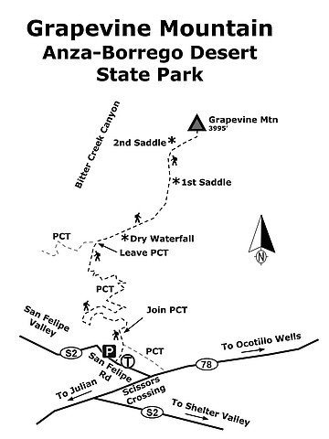
From the parking area, look up the slope to the north/northeast and spot the line traversing across—this is the Pacific Crest Trail (PCT). A faint use trail can be picked up from the parking lot, intersecting the PCT a short distance later. Once on the PCT, turn left (north) to follow the trail as it snakes its way in and out of drainages, steadily climbing in elevation. Dominant plants here include cacti species such as cholla, hedgehog, prickly pear, and barrel cactus. California barrel cactus (Ferocactus cylindraceus) seems to be particularly fond of open, sunny southern slopes. These columnar-shaped cacti can grow up to five feet tall; have long, stiff, and somewhat curved spines; and produce a crown of yellow flowers in the spring. After significant rainfall, the plant expands to store water for drier times to come, an important adaptation for any desert species.
Continuing on, other common plants are encountered, including desert agave, which was a valuable resource to Native Americans due to its multitude of uses as food, fiber, and medicine. There are other thorny flora as well, such as the tall spindly ocotillo and the shrubby catclaw acacia, the latter of which has small hooked spines that quickly latch onto clothing and skin at the slightest touch. More innocuous plants are mixed in as well, such as creosote bush (renowned for becoming especially fragrant after a rain) and brittlebush, a rounded shrub abundantly covering many a desert slope below 4,000 feet and identified by its grey-green leaves and showy yellow flowers in spring.
At around 1.8 miles from the start, the PCT swings inward to a major ravine, and a light-colored swath of rock is visible on the left side of this wash. Leave the trail here and climb up the wash, which trends in a northeast direction. From here, it is all bushwhacking to the top. Soon, you will encounter a couple of dry waterfalls, including one about 20 feet tall but split into two sections, making it passable with only minor scrambling required. Once above it, the remaining dry falls are much shorter and easier to surmount. Continue following the wash up, noticing California junipers (Juniperus californica) beginning to sparsely dot the landscape, indicating the Desert Transition Zone, identified by their densely layered, scaly leaves, and equipped with small pollen cones as well as bluish, berry-like seed cones. If you’re hiking on a warmer day, the shade provided by tese trees of the cypress family can be a welcome relief in otherwise shadeless terrain.
At just over 2 miles, the wash opens up and a steeper slope beckons from above. Climb through brush and rock, following the steepening valley as it makes a slight curve left (north), reaching a ridge just left of the saddle at the 3600-foot contour line, and just right of a false summit. At this point you have traveled about 2.6 miles from the start, though it may feel like more. Here is where Grapevine Mountain comes into view, a half mile further and over 300 feet higher.
Traverse below the high point on your left to reach the saddle just southwest of Grapevine’s summit. This area experienced a fire in 2012, and vegetation has been slow to recover. Take extra care to avoid trampling any plants trying to reestablish themselves in this particularly sensitive environment. Once at the saddle, follow the spine of the ridge up until it flattens out and reaches the summit at 3.1 miles from the start, at an elevation of 3955 feet. A summit register can be found nestled among the rocks for those wishing to add their names to the log of successful ascents of the peak. Views abound, most notably of the looming Granite Mountain to the southwest, as well as the long, gray-colored Whale Peak to the southeast. Also spy smaller summits such as Lizard Peak to the east and, further east still, Sunset Mountain. A look to the north reveals Pinyon Ridge and the San Ysidro Mountains beyond, which lie just west of the town of Borrego Springs. To the west is the high ridge that contains Volcan Mountain. Soak up the views and the solitude, and gather some energy for the trek down.
For the descent, retrace your steps across the summit plateau and pick up the ridge leading down to the saddle. To the right is a steep drop to Bitter Creek Canyon far below, but take care to keep a southwesterly direction and then curve slightly left to traverse under the lower/false summit once again. Pass between this hill and the next saddle to the left to pick up the top of the wash, then begin a cautious descent of the steep slope, as footing is uneven and can be slippery. Soon the canyon walls narrow and the going gets easier, save for the 20-foot dry fall ahead. Once beyond that, the PCT is a short distance away, at which point turn left (south) and enjoy the views down to San Felipe Valley, where fall colors in the trees can create a yellow ribbon at certain times of year. Soon, the large dirt parking lot comes into view, and as you get near, keep a close eye out for the use-trail leading down to it. Arrive at your vehicle about 6.3 miles from the start.
Grapevine Mountain map
Grapevine Mountain (Anza-Borrego Desert State Park)
Views abound on this lofty desert peak.
Directions: (Scissors Crossing) From Julian, go east on CA-78 11.9 miles to Scissors Crossing, and turn left (northwest) onto San Felipe Road. Drive 0.3 mile to a large, raised dirt parking area on the right, which easily has room for a couple dozen vehicles. No facilities. Hiking length: 6.3 miles round trip. Allow 6 hours hiking time. Difficulty: strenuous, with areas of rock scrambling. Elevation gain/loss up to 1,700 feet. The best time to visit this area is November through April as summer months can be quite hot, and there is little shade. Cross-country navigation skills are required for reaching the peak.
Here's something you might be interested in.
Many delights found on Grapevine Mountain, but no grapes
Views abound on this lofty desert peak
Many delights found on Grapevine Mountain, but no grapes
Views abound on this lofty desert peak
Looking down at the parking area near Scissors Crossing.
While no grapes are found on Grapevine Mountain, hikers will surely reap the fruits of their labor from the rewarding views atop this prominent desert peak. Boasting a plethora of views, including Shelter and San Felipe valleys, Granite Mountain, and Whale Peak, as well as many other significant features of Anza-Borrego Desert State Park, this hike has something for everyone. And for those who prefer the journey over the destination, the route described below ensures the hiker will pass by a variety of interesting plants, many of which will be blooming in the spring, as well as a chance to test out one’s scrambling skills, as the off-trail portion includes a couple of dry waterfalls before ascending a steep brush-and-cacti-covered slope.
From the parking area, look up the slope to the north/northeast and spot the line traversing across—this is the Pacific Crest Trail (PCT). A faint use trail can be picked up from the parking lot, intersecting the PCT a short distance later. Once on the PCT, turn left (north) to follow the trail as it snakes its way in and out of drainages, steadily climbing in elevation. Dominant plants here include cacti species such as cholla, hedgehog, prickly pear, and barrel cactus. California barrel cactus (Ferocactus cylindraceus) seems to be particularly fond of open, sunny southern slopes. These columnar-shaped cacti can grow up to five feet tall; have long, stiff, and somewhat curved spines; and produce a crown of yellow flowers in the spring. After significant rainfall, the plant expands to store water for drier times to come, an important adaptation for any desert species.
Continuing on, other common plants are encountered, including desert agave, which was a valuable resource to Native Americans due to its multitude of uses as food, fiber, and medicine. There are other thorny flora as well, such as the tall spindly ocotillo and the shrubby catclaw acacia, the latter of which has small hooked spines that quickly latch onto clothing and skin at the slightest touch. More innocuous plants are mixed in as well, such as creosote bush (renowned for becoming especially fragrant after a rain) and brittlebush, a rounded shrub abundantly covering many a desert slope below 4,000 feet and identified by its grey-green leaves and showy yellow flowers in spring.
At around 1.8 miles from the start, the PCT swings inward to a major ravine, and a light-colored swath of rock is visible on the left side of this wash. Leave the trail here and climb up the wash, which trends in a northeast direction. From here, it is all bushwhacking to the top. Soon, you will encounter a couple of dry waterfalls, including one about 20 feet tall but split into two sections, making it passable with only minor scrambling required. Once above it, the remaining dry falls are much shorter and easier to surmount. Continue following the wash up, noticing California junipers (Juniperus californica) beginning to sparsely dot the landscape, indicating the Desert Transition Zone, identified by their densely layered, scaly leaves, and equipped with small pollen cones as well as bluish, berry-like seed cones. If you’re hiking on a warmer day, the shade provided by tese trees of the cypress family can be a welcome relief in otherwise shadeless terrain.
At just over 2 miles, the wash opens up and a steeper slope beckons from above. Climb through brush and rock, following the steepening valley as it makes a slight curve left (north), reaching a ridge just left of the saddle at the 3600-foot contour line, and just right of a false summit. At this point you have traveled about 2.6 miles from the start, though it may feel like more. Here is where Grapevine Mountain comes into view, a half mile further and over 300 feet higher.
Traverse below the high point on your left to reach the saddle just southwest of Grapevine’s summit. This area experienced a fire in 2012, and vegetation has been slow to recover. Take extra care to avoid trampling any plants trying to reestablish themselves in this particularly sensitive environment. Once at the saddle, follow the spine of the ridge up until it flattens out and reaches the summit at 3.1 miles from the start, at an elevation of 3955 feet. A summit register can be found nestled among the rocks for those wishing to add their names to the log of successful ascents of the peak. Views abound, most notably of the looming Granite Mountain to the southwest, as well as the long, gray-colored Whale Peak to the southeast. Also spy smaller summits such as Lizard Peak to the east and, further east still, Sunset Mountain. A look to the north reveals Pinyon Ridge and the San Ysidro Mountains beyond, which lie just west of the town of Borrego Springs. To the west is the high ridge that contains Volcan Mountain. Soak up the views and the solitude, and gather some energy for the trek down.
For the descent, retrace your steps across the summit plateau and pick up the ridge leading down to the saddle. To the right is a steep drop to Bitter Creek Canyon far below, but take care to keep a southwesterly direction and then curve slightly left to traverse under the lower/false summit once again. Pass between this hill and the next saddle to the left to pick up the top of the wash, then begin a cautious descent of the steep slope, as footing is uneven and can be slippery. Soon the canyon walls narrow and the going gets easier, save for the 20-foot dry fall ahead. Once beyond that, the PCT is a short distance away, at which point turn left (south) and enjoy the views down to San Felipe Valley, where fall colors in the trees can create a yellow ribbon at certain times of year. Soon, the large dirt parking lot comes into view, and as you get near, keep a close eye out for the use-trail leading down to it. Arrive at your vehicle about 6.3 miles from the start.
Grapevine Mountain map
Grapevine Mountain (Anza-Borrego Desert State Park)
Views abound on this lofty desert peak.
Directions: (Scissors Crossing) From Julian, go east on CA-78 11.9 miles to Scissors Crossing, and turn left (northwest) onto San Felipe Road. Drive 0.3 mile to a large, raised dirt parking area on the right, which easily has room for a couple dozen vehicles. No facilities. Hiking length: 6.3 miles round trip. Allow 6 hours hiking time. Difficulty: strenuous, with areas of rock scrambling. Elevation gain/loss up to 1,700 feet. The best time to visit this area is November through April as summer months can be quite hot, and there is little shade. Cross-country navigation skills are required for reaching the peak.
Comments