Here's something you might be interested in.
Ask a Hipster — Advice you didn't know you needed
Big Screen — Movie commentary
Blurt — Music's inside track
Booze News — San Diego spirits
Classical Music — Immortal beauty
Classifieds — Free and easy
Close to Home — What it’s like on the street where you live
Cover Stories — Front-page features
Drinks All Around — Bartenders' drink recipes
Excerpts — Literary and spiritual excerpts
Feast! — Food & drink reviews
Feature Stories — Local news & stories
Fishing Report — What’s getting hooked from ship and shore
From the Archives — Spotlight on the past
Golden Dreams — Talk of the town
The Gonzo Report — Making the musical scene, or at least reporting from it
Letters — Our inbox
Movies@Home — Local movie buffs share favorites
Movie Reviews — Our critics' picks and pans
Musician Interviews — Up close with local artists
Neighborhood News from Stringers — Hyperlocal news
News Ticker — News & politics
Obermeyer — San Diego politics illustrated
Outdoors — Weekly changes in flora and fauna
Overheard in San Diego — Eavesdropping illustrated
Poetry — The old and the new
Reader Travel — Travel section built by travelers
Reading — The hunt for intellectuals
Roam-O-Rama — SoCal's best hiking/biking trails
San Diego Beer — Inside San Diego suds
SD on the QT — Almost factual news
Sheep and Goats — Places of worship
Special Issues — The best of
Street Style — San Diego streets have style
Surf Diego — Real stories from those braving the waves
Theater — On stage in San Diego this week
Tin Fork — Silver spoon alternative
Under the Radar — Matt Potter's undercover work
Unforgettable — Long-ago San Diego
Unreal Estate — San Diego's priciest pads
Your Week — Daily event picks
Bitter Creek Canyon: rich with desert cacti and multiple dry waterfalls
Find sweet solitude in the shadow of Grapevine Mountain
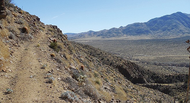
Hiking south on the PCT
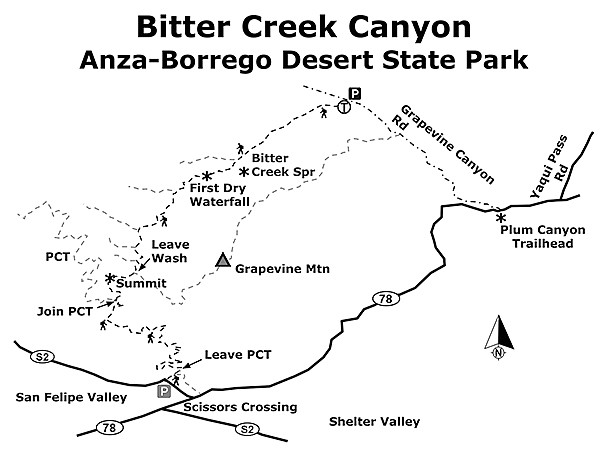
At the western fringes of Anza-Borrego Desert State Park below the San Felipe Hills, you will find solitude in a broad canyon rich with a variety of desert cacti and shrubs, as well as multiple dry waterfalls and a nearby spring that is a draw for wildlife. The one-way, point-to-point hike described below begins in Grapevine Canyon and travels southwesterly along the gently inclining Bitter Creek Wash to a high point overlooking San Felipe and Earthquake Valleys. The remainder of the trip follows the Pacific Crest Trail (PCT) as it lazily winds its way around the southern flanks of Grapevine Mountain to the exit point near Scissors Crossing. This hike requires leaving a vehicle at each end of the hike or arranging for a drop off/pick up.
From the parking area in Grapevine Canyon, turn west to enter the wide valley, hugging the southern edge for the easiest path. This lower end of Bitter Creek Canyon is plentiful with ocotillo (the tall, spindly shrub with many branches adorned with short spines and brilliant red tubular flowers often visited by hummingbirds), and chuparosa (a shrub with red tubular blooms similar to the ocotillo’s but with dense pale green stems and reaching usually no more than about two feet in height). Another common native shrub in this area is ephedra, or Mormon tea, identifiable by its slender grey-green jointed stems equipped with tiny cones, a key characteristic of gymnosperms. As the name suggests, this plant contains ephedrine and was used as a stimulant by the Mormons when made into a tea, and native Americans enjoyed ephedra as a general tonic. You will also pass by Gander’s cholla, a cactus armed with many spiny segments and displaying yellowish-green flowers, as well as desert agave, a hearty plant that shoots up a tall, sugar-rich stalk resembling a giant asparagus before culminating in panicles of yellow flowers.
At just under 1.3 miles, you’ll reach the first of several forks in the wash. Keep left here as the canyon narrows and clamber up and around boulders soon afterward. Look up to the left on the lower slope of Grapevine Mountain and spot a patch of green vegetation about 150 feet up the hill—this is Bitter Creek Spring, so named for its alkaline-rich water with a bitter taste. Historically, this spring was used by ranchers to water cattle, and today it is utilized regularly by wildlife as an important water source. If you have time for a side trip, check out the spring and see what animal tracks you can identify.
Continuing on, notice the creosote bushes with their fragrant small green leaves, especially aromatic after rain. Catclaw acacia comes and goes, a thorny shrub whose curved, claw-like spines easily grab on to skin and clothing, tearing all but the toughest of fabric. Brittlebush may be in bloom, a common springtime delight in the park with its signature large sunny yellow flowers atop a rounded grey-green shrub. A variety of cacti inhabit this area as well, including hedgehog, beavertail, and barrel cactus.
At 1.75 miles, you will reach the first of many dry waterfalls. Climb above it and continue on, passing by dudleya clinging to the rocky edges of the wash (a small rosette of fleshy green leaves that sends out tentacle-like arms with pinkish-red flowers) and a patch of the invasive tamarisk (or salt cedar) tree, commonly found in moist areas.
At just over 2.1 miles, reach another fork and go left. Brushy thickets containing mesquite trees may impede progress—bypass on the left to avoid getting hung up in the mess, keeping on course in the main wash. At 2.7 miles, the wash forks again—turn left. A short distance later, at just over 2.9 miles, is another split—go left and cross a fence shortly thereafter. At just over 3.1 miles comes the last fork, at which point you’ll once again turn left. Soon after there is an odd sight: a large, seemingly out-of-place boulder in the middle of the wash, composed of many layers of varying color and texture. Pause here for a moment to marvel at the mystery of its origin and take a look around to see if you can find any similar rocks nearby.
As you climb to the upper reaches of the wash, you may come across the occasional indigo bush, a member of the pea family with striking bluish-purple flowers against a complicated array of whitish-grey branches. Flat-top buckwheat is a common sight, and small juniper trees sparsely dot the landscape and may provide welcome shade on a warm day.
At just under 3.6 miles, find a good place to leave the wash and climb to a viewpoint overlooking the San Felipe Valley, just on the other side of the ridge above. Veer right uphill, climbing the steep slope to the high point, marked 3,350 feet in elevation on some topographical maps. You should now be approximately 3.8 miles from the start and a little more than halfway through the hike. A large patch of prickly-pear cacti is found at the summit, but there is adequate space around it to take a seat and enjoy the views. Directly below to the west is the San Felipe Valley, with the Volcan Mountains looming behind. To the south stretches Earthquake or Shelter Valley. The big peak to the near east is Grapevine Mountain, a worthy trip on its own for those seeking a more challenging climb.
After enjoying your break at the summit, note the well-maintained trail visible on the slopes just below you to the south. This is the PCT and will be your route for the remainder of the hike. To reach it, locate a small drainage to your left (south) and carefully make your way down the somewhat slippery terrain of rocks, low bushes, and cacti until the drainage meets the trail at just over 4.1 miles. Turn left (south) on the PCT and follow it as it makes numerous turns around the ridges coming down from Grapevine Mountain. This stretch of trail is sparsely vegetated and can be quite hot, so patience and an adequate water supply are necessary. Various types of cacti are still prevalent, as well as the occasional desert tobacco (a leafy green surprise with small white flowers) and desert trumpet (a perennial with long stems sporting a characteristic bulge just below a spread of tiny yellow flowers).
Soon the parking area will be visible in the distance; however, it is further away than it appears due to the circuitous nature of the trail. Eventually, at 7.2 miles, leave the PCT and turn right down a wash, reaching the parking lot and your vehicle at just over 7.3 miles. All that remains now is the short drive back to the Grapevine Canyon trailhead to retrieve the other vehicle.
BITTER CREEK CANYON
Find sweet solitude in the shadow of Grapevine Mountain.
Bitter Creek Canyon map
Driving directions: (Scissors Crossing) EAST END (high clearance vehicle recommended): From CA-78 turn north onto Grapevine Canyon Road (look for a small brown sign across the road from the Plum Canyon trailhead) and drive 2 miles until you reach a wide valley on the left. Park in one of the pullouts off the road, being careful to leave enough space for any vehicles that may come through during the day. No facilities. WEST END: From CA-78 turn north on S-2 (San Felipe Road) and go 0.3 mile to a large dirt parking lot on the right, an access point to the PCT is on the slope above. No facilities. Hiking length: 7.4 miles one-way. Allow 5.5 hours hiking time. Difficulty: Moderately strenuous, with areas of rock scrambling and cross-country travel. Elevation gain/loss: Up to 1,350 feet. Navigational skills required; GPS use recommended. The best time to visit this area is November through April, as summer months can be quite hot and there is little shade.
Here's something you might be interested in.
Bitter Creek Canyon: rich with desert cacti and multiple dry waterfalls
Find sweet solitude in the shadow of Grapevine Mountain
Bitter Creek Canyon: rich with desert cacti and multiple dry waterfalls
Find sweet solitude in the shadow of Grapevine Mountain
Hiking south on the PCT
At the western fringes of Anza-Borrego Desert State Park below the San Felipe Hills, you will find solitude in a broad canyon rich with a variety of desert cacti and shrubs, as well as multiple dry waterfalls and a nearby spring that is a draw for wildlife. The one-way, point-to-point hike described below begins in Grapevine Canyon and travels southwesterly along the gently inclining Bitter Creek Wash to a high point overlooking San Felipe and Earthquake Valleys. The remainder of the trip follows the Pacific Crest Trail (PCT) as it lazily winds its way around the southern flanks of Grapevine Mountain to the exit point near Scissors Crossing. This hike requires leaving a vehicle at each end of the hike or arranging for a drop off/pick up.
From the parking area in Grapevine Canyon, turn west to enter the wide valley, hugging the southern edge for the easiest path. This lower end of Bitter Creek Canyon is plentiful with ocotillo (the tall, spindly shrub with many branches adorned with short spines and brilliant red tubular flowers often visited by hummingbirds), and chuparosa (a shrub with red tubular blooms similar to the ocotillo’s but with dense pale green stems and reaching usually no more than about two feet in height). Another common native shrub in this area is ephedra, or Mormon tea, identifiable by its slender grey-green jointed stems equipped with tiny cones, a key characteristic of gymnosperms. As the name suggests, this plant contains ephedrine and was used as a stimulant by the Mormons when made into a tea, and native Americans enjoyed ephedra as a general tonic. You will also pass by Gander’s cholla, a cactus armed with many spiny segments and displaying yellowish-green flowers, as well as desert agave, a hearty plant that shoots up a tall, sugar-rich stalk resembling a giant asparagus before culminating in panicles of yellow flowers.
At just under 1.3 miles, you’ll reach the first of several forks in the wash. Keep left here as the canyon narrows and clamber up and around boulders soon afterward. Look up to the left on the lower slope of Grapevine Mountain and spot a patch of green vegetation about 150 feet up the hill—this is Bitter Creek Spring, so named for its alkaline-rich water with a bitter taste. Historically, this spring was used by ranchers to water cattle, and today it is utilized regularly by wildlife as an important water source. If you have time for a side trip, check out the spring and see what animal tracks you can identify.
Continuing on, notice the creosote bushes with their fragrant small green leaves, especially aromatic after rain. Catclaw acacia comes and goes, a thorny shrub whose curved, claw-like spines easily grab on to skin and clothing, tearing all but the toughest of fabric. Brittlebush may be in bloom, a common springtime delight in the park with its signature large sunny yellow flowers atop a rounded grey-green shrub. A variety of cacti inhabit this area as well, including hedgehog, beavertail, and barrel cactus.
At 1.75 miles, you will reach the first of many dry waterfalls. Climb above it and continue on, passing by dudleya clinging to the rocky edges of the wash (a small rosette of fleshy green leaves that sends out tentacle-like arms with pinkish-red flowers) and a patch of the invasive tamarisk (or salt cedar) tree, commonly found in moist areas.
At just over 2.1 miles, reach another fork and go left. Brushy thickets containing mesquite trees may impede progress—bypass on the left to avoid getting hung up in the mess, keeping on course in the main wash. At 2.7 miles, the wash forks again—turn left. A short distance later, at just over 2.9 miles, is another split—go left and cross a fence shortly thereafter. At just over 3.1 miles comes the last fork, at which point you’ll once again turn left. Soon after there is an odd sight: a large, seemingly out-of-place boulder in the middle of the wash, composed of many layers of varying color and texture. Pause here for a moment to marvel at the mystery of its origin and take a look around to see if you can find any similar rocks nearby.
As you climb to the upper reaches of the wash, you may come across the occasional indigo bush, a member of the pea family with striking bluish-purple flowers against a complicated array of whitish-grey branches. Flat-top buckwheat is a common sight, and small juniper trees sparsely dot the landscape and may provide welcome shade on a warm day.
At just under 3.6 miles, find a good place to leave the wash and climb to a viewpoint overlooking the San Felipe Valley, just on the other side of the ridge above. Veer right uphill, climbing the steep slope to the high point, marked 3,350 feet in elevation on some topographical maps. You should now be approximately 3.8 miles from the start and a little more than halfway through the hike. A large patch of prickly-pear cacti is found at the summit, but there is adequate space around it to take a seat and enjoy the views. Directly below to the west is the San Felipe Valley, with the Volcan Mountains looming behind. To the south stretches Earthquake or Shelter Valley. The big peak to the near east is Grapevine Mountain, a worthy trip on its own for those seeking a more challenging climb.
After enjoying your break at the summit, note the well-maintained trail visible on the slopes just below you to the south. This is the PCT and will be your route for the remainder of the hike. To reach it, locate a small drainage to your left (south) and carefully make your way down the somewhat slippery terrain of rocks, low bushes, and cacti until the drainage meets the trail at just over 4.1 miles. Turn left (south) on the PCT and follow it as it makes numerous turns around the ridges coming down from Grapevine Mountain. This stretch of trail is sparsely vegetated and can be quite hot, so patience and an adequate water supply are necessary. Various types of cacti are still prevalent, as well as the occasional desert tobacco (a leafy green surprise with small white flowers) and desert trumpet (a perennial with long stems sporting a characteristic bulge just below a spread of tiny yellow flowers).
Soon the parking area will be visible in the distance; however, it is further away than it appears due to the circuitous nature of the trail. Eventually, at 7.2 miles, leave the PCT and turn right down a wash, reaching the parking lot and your vehicle at just over 7.3 miles. All that remains now is the short drive back to the Grapevine Canyon trailhead to retrieve the other vehicle.
BITTER CREEK CANYON
Find sweet solitude in the shadow of Grapevine Mountain.
Bitter Creek Canyon map
Driving directions: (Scissors Crossing) EAST END (high clearance vehicle recommended): From CA-78 turn north onto Grapevine Canyon Road (look for a small brown sign across the road from the Plum Canyon trailhead) and drive 2 miles until you reach a wide valley on the left. Park in one of the pullouts off the road, being careful to leave enough space for any vehicles that may come through during the day. No facilities. WEST END: From CA-78 turn north on S-2 (San Felipe Road) and go 0.3 mile to a large dirt parking lot on the right, an access point to the PCT is on the slope above. No facilities. Hiking length: 7.4 miles one-way. Allow 5.5 hours hiking time. Difficulty: Moderately strenuous, with areas of rock scrambling and cross-country travel. Elevation gain/loss: Up to 1,350 feet. Navigational skills required; GPS use recommended. The best time to visit this area is November through April, as summer months can be quite hot and there is little shade.
Comments