Here's something you might be interested in.
Ask a Hipster — Advice you didn't know you needed
Big Screen — Movie commentary
Blurt — Music's inside track
Booze News — San Diego spirits
Classical Music — Immortal beauty
Classifieds — Free and easy
Close to Home — What it’s like on the street where you live
Cover Stories — Front-page features
Drinks All Around — Bartenders' drink recipes
Excerpts — Literary and spiritual excerpts
Feast! — Food & drink reviews
Feature Stories — Local news & stories
Fishing Report — What’s getting hooked from ship and shore
From the Archives — Spotlight on the past
Golden Dreams — Talk of the town
The Gonzo Report — Making the musical scene, or at least reporting from it
Letters — Our inbox
Movies@Home — Local movie buffs share favorites
Movie Reviews — Our critics' picks and pans
Musician Interviews — Up close with local artists
Neighborhood News from Stringers — Hyperlocal news
News Ticker — News & politics
Obermeyer — San Diego politics illustrated
Outdoors — Weekly changes in flora and fauna
Overheard in San Diego — Eavesdropping illustrated
Poetry — The old and the new
Reader Travel — Travel section built by travelers
Reading — The hunt for intellectuals
Roam-O-Rama — SoCal's best hiking/biking trails
San Diego Beer — Inside San Diego suds
SD on the QT — Almost factual news
Sheep and Goats — Places of worship
Special Issues — The best of
Street Style — San Diego streets have style
Surf Diego — Real stories from those braving the waves
Theater — On stage in San Diego this week
Tin Fork — Silver spoon alternative
Under the Radar — Matt Potter's undercover work
Unforgettable — Long-ago San Diego
Unreal Estate — San Diego's priciest pads
Your Week — Daily event picks
Anza Borrego's Diablo — a triple divide peak
It confounds logic
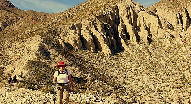
Ridgeline north of Diablo saddle
It was the view from Diablo Peak’s north saddle that Anza-Borrego Desert State Park rangers first discovered Fish Creek’s popular Sandstone Canyon in the 1950s. The view of Sandstone Canyon continues to impress those who look down upon this twisting canyon that eventually melts into Fish Creek.
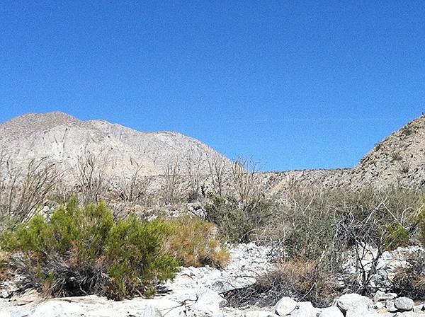
Ridgeline separating Sandstone Canyon from June Wash
The saddle and ridgeline, which is the goal of this hike, is at the headwaters of the Sandstone Canyon/Fish Creek drainage system and the June Wash/Vallecito drainage system. It is the divide between the San Felipe watershed of the northern Anza-Borrego region and the Carrizo watershed of the southern region. It confounds logic to have such a divide on the south side of the mile-high barrier of the Vallecito Mountains. The explanation is that Fish Creek cuts through the Vallecito Mountains at Split Mountain to join the San Felipe Wash system to the north. Fish Creek, as an antecedent or pre-existing stream, has been able to maintain its course by downward erosion faster than tectonic forces are uplifting the Vallecitos.
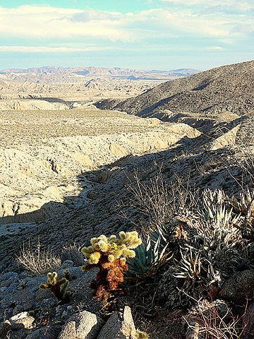
View from saddle
Begin the hike from June Wash, 2 miles from the road entrance. Head northwest a half mile, following a wash that passes through two low ridges. This is actually June Wash. The road from your parked vehicle continues up the north fork of June Wash, which is misidentified as June Wash on some maps or called “false” June Wash.
June Wash turns north after passing the two low ridges and immediately comes to a split. Stay to the left (west) and continue up-canyon 1.5 miles to where there is another split. Again, stay left (west). In less than a half mile from the second split, the canyon will open up with main June Wash continuing on to the north.
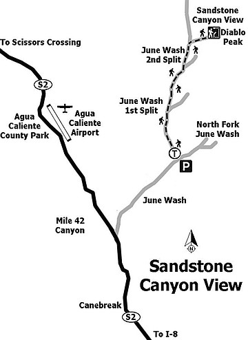
Sandstone Canyon map
Turn right (east), which is due west of survey point “Diablo.” If you are using a topo map, this survey point is on the north boundary of Section 3 on the 7.5-minute Agua Caliente topo map. It is the high peak that you will need to round to reach the viewpoint. Head northeast about 0.4 mile and climb the saddle (elevation 2075 feet) between Diablo Benchmark/Peak and the ridge to the north to get the view down into Sandstone Canyon.
From the viewpoint at the saddle, it is a very steep climb/scramble, slightly more than 300 feet in less than a half mile, to the top of Diablo Benchmark (elevation 2440 feet). The effort is well worth it for the great view of the surrounding watersheds. Diablo is actually a triple divide peak with water entering three watersheds from the peak: Fish Creek, Vallecito/Carrizo, and Arroyo/Tapiado/Arroyo Seco del Diablo, to the southeast. If you climb to the top of Diablo Benchmark, you will add another mile to the trip. After enjoying the view, retrace your steps back to your vehicle.
Distance from downtown San Diego: 114 miles. Allow 2 hours (Anza-Borrego Desert State Park). From SR-163N, take I-8E, exiting on the Imperial Hwy at Ocotillo, after 88 miles. Turn north on SR-2 (Imperial Hwy) and drive 23.4 miles to the turnoff on the right for June Wash (signed), about one-half mile beyond highway mile-marker 42. Drive 2 miles up June Wash and park. This dirt road has some soft sand. If concerned about the sand, park at the entrance to June Wash and walk up the wash 2 miles. No facilities. Hiking length: 6.25 or 10.25 miles out-and-back, depending on where the vehicle is parked. If you climb to the top of Diablo Peak, it will add another mile to the trip; 5–8 hours, depending on start point and whether or not you climb Diablo Peak. Difficulty: Moderately strenuous to strenuous. Elevation gain/loss 825–1190 feet. Carry extra water.
Here's something you might be interested in.
Anza Borrego's Diablo — a triple divide peak
It confounds logic
Anza Borrego's Diablo — a triple divide peak
It confounds logic
Ridgeline north of Diablo saddle
It was the view from Diablo Peak’s north saddle that Anza-Borrego Desert State Park rangers first discovered Fish Creek’s popular Sandstone Canyon in the 1950s. The view of Sandstone Canyon continues to impress those who look down upon this twisting canyon that eventually melts into Fish Creek.
Ridgeline separating Sandstone Canyon from June Wash
The saddle and ridgeline, which is the goal of this hike, is at the headwaters of the Sandstone Canyon/Fish Creek drainage system and the June Wash/Vallecito drainage system. It is the divide between the San Felipe watershed of the northern Anza-Borrego region and the Carrizo watershed of the southern region. It confounds logic to have such a divide on the south side of the mile-high barrier of the Vallecito Mountains. The explanation is that Fish Creek cuts through the Vallecito Mountains at Split Mountain to join the San Felipe Wash system to the north. Fish Creek, as an antecedent or pre-existing stream, has been able to maintain its course by downward erosion faster than tectonic forces are uplifting the Vallecitos.
View from saddle
Begin the hike from June Wash, 2 miles from the road entrance. Head northwest a half mile, following a wash that passes through two low ridges. This is actually June Wash. The road from your parked vehicle continues up the north fork of June Wash, which is misidentified as June Wash on some maps or called “false” June Wash.
June Wash turns north after passing the two low ridges and immediately comes to a split. Stay to the left (west) and continue up-canyon 1.5 miles to where there is another split. Again, stay left (west). In less than a half mile from the second split, the canyon will open up with main June Wash continuing on to the north.
Sandstone Canyon map
Turn right (east), which is due west of survey point “Diablo.” If you are using a topo map, this survey point is on the north boundary of Section 3 on the 7.5-minute Agua Caliente topo map. It is the high peak that you will need to round to reach the viewpoint. Head northeast about 0.4 mile and climb the saddle (elevation 2075 feet) between Diablo Benchmark/Peak and the ridge to the north to get the view down into Sandstone Canyon.
From the viewpoint at the saddle, it is a very steep climb/scramble, slightly more than 300 feet in less than a half mile, to the top of Diablo Benchmark (elevation 2440 feet). The effort is well worth it for the great view of the surrounding watersheds. Diablo is actually a triple divide peak with water entering three watersheds from the peak: Fish Creek, Vallecito/Carrizo, and Arroyo/Tapiado/Arroyo Seco del Diablo, to the southeast. If you climb to the top of Diablo Benchmark, you will add another mile to the trip. After enjoying the view, retrace your steps back to your vehicle.
Distance from downtown San Diego: 114 miles. Allow 2 hours (Anza-Borrego Desert State Park). From SR-163N, take I-8E, exiting on the Imperial Hwy at Ocotillo, after 88 miles. Turn north on SR-2 (Imperial Hwy) and drive 23.4 miles to the turnoff on the right for June Wash (signed), about one-half mile beyond highway mile-marker 42. Drive 2 miles up June Wash and park. This dirt road has some soft sand. If concerned about the sand, park at the entrance to June Wash and walk up the wash 2 miles. No facilities. Hiking length: 6.25 or 10.25 miles out-and-back, depending on where the vehicle is parked. If you climb to the top of Diablo Peak, it will add another mile to the trip; 5–8 hours, depending on start point and whether or not you climb Diablo Peak. Difficulty: Moderately strenuous to strenuous. Elevation gain/loss 825–1190 feet. Carry extra water.
Comments