Here's something you might be interested in.
Ask a Hipster — Advice you didn't know you needed
Big Screen — Movie commentary
Blurt — Music's inside track
Booze News — San Diego spirits
Classical Music — Immortal beauty
Classifieds — Free and easy
Close to Home — What it’s like on the street where you live
Cover Stories — Front-page features
Drinks All Around — Bartenders' drink recipes
Excerpts — Literary and spiritual excerpts
Feast! — Food & drink reviews
Feature Stories — Local news & stories
Fishing Report — What’s getting hooked from ship and shore
From the Archives — Spotlight on the past
Golden Dreams — Talk of the town
The Gonzo Report — Making the musical scene, or at least reporting from it
Letters — Our inbox
Movies@Home — Local movie buffs share favorites
Movie Reviews — Our critics' picks and pans
Musician Interviews — Up close with local artists
Neighborhood News from Stringers — Hyperlocal news
News Ticker — News & politics
Obermeyer — San Diego politics illustrated
Outdoors — Weekly changes in flora and fauna
Overheard in San Diego — Eavesdropping illustrated
Poetry — The old and the new
Reader Travel — Travel section built by travelers
Reading — The hunt for intellectuals
Roam-O-Rama — SoCal's best hiking/biking trails
San Diego Beer — Inside San Diego suds
SD on the QT — Almost factual news
Sheep and Goats — Places of worship
Special Issues — The best of
Street Style — San Diego streets have style
Surf Diego — Real stories from those braving the waves
Theater — On stage in San Diego this week
Tin Fork — Silver spoon alternative
Under the Radar — Matt Potter's undercover work
Unforgettable — Long-ago San Diego
Unreal Estate — San Diego's priciest pads
Your Week — Daily event picks
Park in the hard-packed sand when visiting Bedrock
Let your imagination run wild among the bizarre shapes of wind-carved caves.
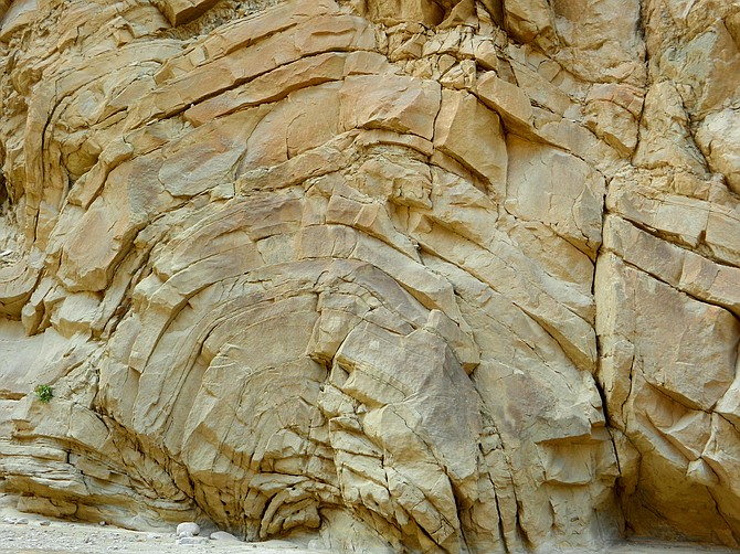
A large anticline in Split Mountain
On the eastern edge of Anza-Borrego Desert State Park lies Split Mountain, the Carrizo Badlands, and a feature known as the Wind Caves. Here, the exposed sandstone of the marine beds from the five-million-year-old Imperial Formation have been slowly eroded by wind into fantastic shapes that evoke whimsical images of boats with portholes, spaceships, and even the fictional town of Bedrock, hometown of the prehistoric Flintstone family.
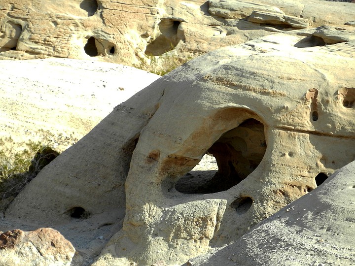
Wind-carved sandstone formations
The journey to the Wind Caves starts by driving off-road up Fish Creek Wash toward Split Mountain Gorge. At 1.4 miles, Fish Creek Primitive Campground is to the left (east). If unsure of clearance or driving in loose sand further into the wash, this is a good place to park your vehicle and continue on foot. This adds another 5.5 miles (round trip) to the hike.
Continuing on, you will soon enter the realm of Split Mountain Gorge, with sheer vertical walls towering hundreds of feet. The road winds through the gorge that is the dividing line between the Vallecito Mountains on the west and the Fish Creek Mountains on the east. Split Mountain Gorge was cut by an ancient stream that ran through a fault between the two ranges a million years ago. As the mountains continued to rise, the stream held its course and slowly eroded the gorge that we see today.
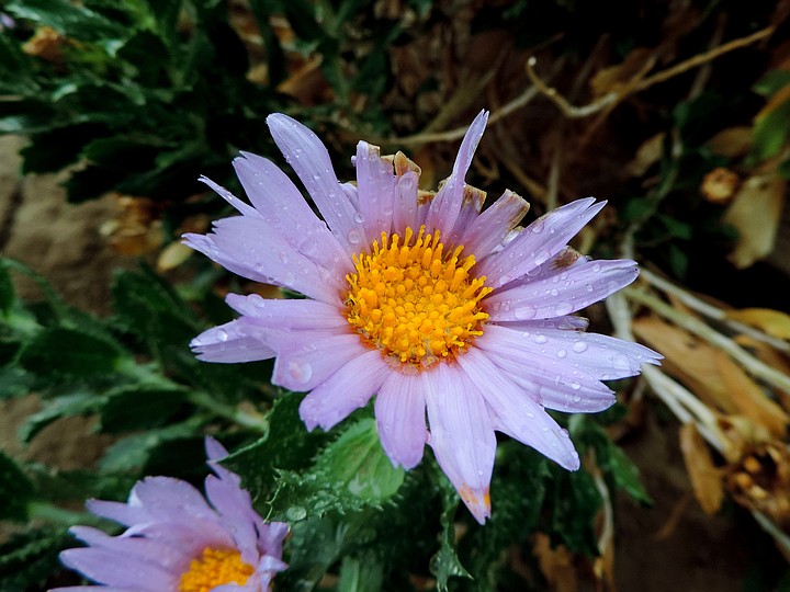
Aster clings precariously to the walls of Split Mountain Gorge
At 2.5 miles, there is an arch-like formation on the west wall (right side) of the gorge known as the “anticline.” It was formed five million years ago, when an earthquake caused a massive landslide that deposited hundreds of millions of cubic yards of rock into the shallow sea that once covered this area. The force and speed of the slide warped the sand of the seafloor into the semi-circular layers seen here, much like carpeting being pushed against a wall. Also, be on the lookout for the green leaves and purple flowers of Orcutt’s aster (Xylorhiza orcuttii) clinging to the rock walls of the gorge. While fairly common in Fish Creek, it is rare in most other areas of the desert park. Among other bloomers, the yellow-tassel-topped flowers of trixis and the purple flower stock of Arizona lupine may be found in the shade along the sides of the wash.
The gorge suddenly opens at about 4 miles, and in another 0.2 mile, there is a sign for the Wind Caves Trail on the left. Be sure to park in hard-packed sand, otherwise your vehicle may need to be towed or pushed upon return.
The hike begins with a climb up the east side of Split Mountain Wash on a series of rocky steps. As the trail ascends, there are soon outstanding views of the Carrizo Badlands, looking like huge frozen waves on a rough ocean. The Elephant Knees Formation is the prominent feature to the south. The fluted hills, while resembling the knees of giant elephants, are the remnants of a fossil reef formed 20 million years ago when the Gulf of California covered the region. After walking 0.2 mile, go straight and continue to climb at the first fork in the trail. The trail to the right will be the return route. In a few hundred feet, go to the right and on to the Wind Caves — the left fork continues for 1 mile to the 1700-foot summit of Split Mountain East. After turning right at the fork and continuing about 0.7 mile, the Wind Caves will come into view. Explore the rooms, alcoves, and tunnels to be found here. See if you can identify the formations known as “The Phantom” and “The Ghost.” There is evidence that Native Americans used the caves for shelter. Remember: there is no collecting of any kind allowed in the park, so return to the same spot anything you find.
When finished exploring, find a route down to the trail immediately below the caves. Take this less-used single track west as it descends to another small collection of sandstone caves. This track rejoins the main trail not far above the wash and makes for a nice loop hike. Descend to the wash and your vehicle to retrace your drive through Split Mountain Gorge and to the road.
Wind caves trail map
WIND CAVES
Distance from downtown San Diego: 110 miles. Allow 2.5 hours driving time (Ocotillo Wells). From Julian, drive east on SR-78 for 33.5 miles to Split Mountain Rd. and turn right (south). Continue 8.1 miles and turn right (southwest) at Fish Creek Wash. Drive off- road, following the unpaved road as it turns south 4.2 miles to the signed trailhead for the Wind Caves. High-clearance or 4WD recommended to drive up Fish Creek Wash, which can be very sandy and have sizable rocks in some places. For current conditions, contact Anza-Borrego Desert State Park Visitor Center 760-767-4205.
Hiking Length: 2 miles (or longer, if not driving up the wash). Allow at least one hour.
Difficulty: Moderate with about 250 feet of elevation gain/loss. Dogs and mountain bikes not allowed. Facilities at Fish Creek Primitive Campground.
Here's something you might be interested in.
Park in the hard-packed sand when visiting Bedrock
Let your imagination run wild among the bizarre shapes of wind-carved caves.
Park in the hard-packed sand when visiting Bedrock
Let your imagination run wild among the bizarre shapes of wind-carved caves.
A large anticline in Split Mountain
On the eastern edge of Anza-Borrego Desert State Park lies Split Mountain, the Carrizo Badlands, and a feature known as the Wind Caves. Here, the exposed sandstone of the marine beds from the five-million-year-old Imperial Formation have been slowly eroded by wind into fantastic shapes that evoke whimsical images of boats with portholes, spaceships, and even the fictional town of Bedrock, hometown of the prehistoric Flintstone family.
Wind-carved sandstone formations
The journey to the Wind Caves starts by driving off-road up Fish Creek Wash toward Split Mountain Gorge. At 1.4 miles, Fish Creek Primitive Campground is to the left (east). If unsure of clearance or driving in loose sand further into the wash, this is a good place to park your vehicle and continue on foot. This adds another 5.5 miles (round trip) to the hike.
Continuing on, you will soon enter the realm of Split Mountain Gorge, with sheer vertical walls towering hundreds of feet. The road winds through the gorge that is the dividing line between the Vallecito Mountains on the west and the Fish Creek Mountains on the east. Split Mountain Gorge was cut by an ancient stream that ran through a fault between the two ranges a million years ago. As the mountains continued to rise, the stream held its course and slowly eroded the gorge that we see today.
Aster clings precariously to the walls of Split Mountain Gorge
At 2.5 miles, there is an arch-like formation on the west wall (right side) of the gorge known as the “anticline.” It was formed five million years ago, when an earthquake caused a massive landslide that deposited hundreds of millions of cubic yards of rock into the shallow sea that once covered this area. The force and speed of the slide warped the sand of the seafloor into the semi-circular layers seen here, much like carpeting being pushed against a wall. Also, be on the lookout for the green leaves and purple flowers of Orcutt’s aster (Xylorhiza orcuttii) clinging to the rock walls of the gorge. While fairly common in Fish Creek, it is rare in most other areas of the desert park. Among other bloomers, the yellow-tassel-topped flowers of trixis and the purple flower stock of Arizona lupine may be found in the shade along the sides of the wash.
The gorge suddenly opens at about 4 miles, and in another 0.2 mile, there is a sign for the Wind Caves Trail on the left. Be sure to park in hard-packed sand, otherwise your vehicle may need to be towed or pushed upon return.
The hike begins with a climb up the east side of Split Mountain Wash on a series of rocky steps. As the trail ascends, there are soon outstanding views of the Carrizo Badlands, looking like huge frozen waves on a rough ocean. The Elephant Knees Formation is the prominent feature to the south. The fluted hills, while resembling the knees of giant elephants, are the remnants of a fossil reef formed 20 million years ago when the Gulf of California covered the region. After walking 0.2 mile, go straight and continue to climb at the first fork in the trail. The trail to the right will be the return route. In a few hundred feet, go to the right and on to the Wind Caves — the left fork continues for 1 mile to the 1700-foot summit of Split Mountain East. After turning right at the fork and continuing about 0.7 mile, the Wind Caves will come into view. Explore the rooms, alcoves, and tunnels to be found here. See if you can identify the formations known as “The Phantom” and “The Ghost.” There is evidence that Native Americans used the caves for shelter. Remember: there is no collecting of any kind allowed in the park, so return to the same spot anything you find.
When finished exploring, find a route down to the trail immediately below the caves. Take this less-used single track west as it descends to another small collection of sandstone caves. This track rejoins the main trail not far above the wash and makes for a nice loop hike. Descend to the wash and your vehicle to retrace your drive through Split Mountain Gorge and to the road.
Wind caves trail map
WIND CAVES
Distance from downtown San Diego: 110 miles. Allow 2.5 hours driving time (Ocotillo Wells). From Julian, drive east on SR-78 for 33.5 miles to Split Mountain Rd. and turn right (south). Continue 8.1 miles and turn right (southwest) at Fish Creek Wash. Drive off- road, following the unpaved road as it turns south 4.2 miles to the signed trailhead for the Wind Caves. High-clearance or 4WD recommended to drive up Fish Creek Wash, which can be very sandy and have sizable rocks in some places. For current conditions, contact Anza-Borrego Desert State Park Visitor Center 760-767-4205.
Hiking Length: 2 miles (or longer, if not driving up the wash). Allow at least one hour.
Difficulty: Moderate with about 250 feet of elevation gain/loss. Dogs and mountain bikes not allowed. Facilities at Fish Creek Primitive Campground.
Comments