Here's something you might be interested in.
Ask a Hipster — Advice you didn't know you needed
Big Screen — Movie commentary
Blurt — Music's inside track
Booze News — San Diego spirits
Classical Music — Immortal beauty
Classifieds — Free and easy
Close to Home — What it’s like on the street where you live
Cover Stories — Front-page features
Drinks All Around — Bartenders' drink recipes
Excerpts — Literary and spiritual excerpts
Feast! — Food & drink reviews
Feature Stories — Local news & stories
Fishing Report — What’s getting hooked from ship and shore
From the Archives — Spotlight on the past
Golden Dreams — Talk of the town
The Gonzo Report — Making the musical scene, or at least reporting from it
Letters — Our inbox
Movies@Home — Local movie buffs share favorites
Movie Reviews — Our critics' picks and pans
Musician Interviews — Up close with local artists
Neighborhood News from Stringers — Hyperlocal news
News Ticker — News & politics
Obermeyer — San Diego politics illustrated
Outdoors — Weekly changes in flora and fauna
Overheard in San Diego — Eavesdropping illustrated
Poetry — The old and the new
Reader Travel — Travel section built by travelers
Reading — The hunt for intellectuals
Roam-O-Rama — SoCal's best hiking/biking trails
San Diego Beer — Inside San Diego suds
SD on the QT — Almost factual news
Sheep and Goats — Places of worship
Special Issues — The best of
Street Style — San Diego streets have style
Surf Diego — Real stories from those braving the waves
Theater — On stage in San Diego this week
Tin Fork — Silver spoon alternative
Under the Radar — Matt Potter's undercover work
Unforgettable — Long-ago San Diego
Unreal Estate — San Diego's priciest pads
Your Week — Daily event picks
Hear water bubbling over boulders in Santa Ysabel Creek in Boden Canyon
This beautiful canyon has an abundance of great plant diversity.
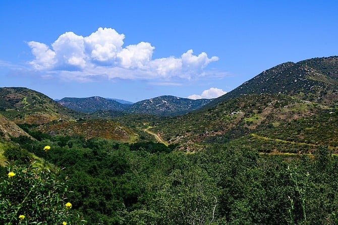
Looking into Boden Canyon and the Boden Canyon Truck Trail
From the staging area, follow the trail leading east. In 0.14 mile, it curves around a ridge and heads south into Clevenger Canyon, parallel to Hwy 78, but well below it. In about half a mile, the trail crosses an intermittent creek under the cover of huge coast live oaks, intermixed with arroyo willows and other riparian species.
After crossing the creek, the trail continues north on the other side of the canyon, gradually leaving the shady oaks behind. At 0.78 mile from the trailhead, you are back looking down into Boden Canyon, where, in winter and spring of years with high rainfall, you can hear water bubbling over boulders in Santa Ysabel Creek down below.
For the next 0.6 mile, the trail follows the contours of the creek, but stays well above it, crossing a hillside facing north to northwest. You can expect an abundance of native wildflowers beside the trail. Yellow and white pincushion, yellow bush penstemon, Chinese houses, blue-eyed grass, peninsular onion, red maids, golden yarrow, California chicory, deerweed, collar lupine, and the Parry larkspur. All are common in years with adequate rainfall. These lend a colorful accent to the many typical flowering chaparral plants: chamise, manzanita, sugar bush, laurel sumac, scrub oak, California sagebrush, buckwheat, black sage, mountain mahogany, and California lilacs.
Santa Ysabel Creek is 1.4 miles from the trailhead. In mid-May of 2019, the flowing water was about 20 meters (65 feet) wide and 10 centimeters (4 inches) deep above a bed of sand of varying depths. Those with low-rise boots will have wet feet, but it is safe to cross here.
Over the next 0.8 mile, the trail climbs a modest hillside, fully exposed to the afternoon sun. As a reward for your hard work in the hot sun, at 2.26 miles from the trailhead, you are back hiking through a cool forest of shady sycamore, coastal live oak, and Engelmann oak, with additional shade provided by blue elderberry trees and large laurel sumac semi-trees.
At 3.01 miles from the trailhead, the Boden Canyon Road (unsigned) joins the trail on the right. Following the road to the right would take you up to the Orosco Ridge. Instead, continue on the trail to the left.
At 3.25 miles, the trail enters an oak grassland, where scattered oaks are interspersed with native and non-native annual grasses, such as cheat grass, ripgut brome, foxtail brome, and wild oat, as well as an abundance of black mustard and filaree. In some places, the trail is overgrown with these annuals and difficult to follow.
Near an opening at 3.4 miles, a short trail leads off to the left, travels on top of an earthen dam, and ends at a concrete spillway. The dam creates a small pond that, even in this wet year, contains very little water. Previous visitors have described the pond as open water ringed with cattails. Currently there are few if any cattails, and the pond basin is choked with dead branches, possibly the former cattails, between which there are small puddles. While it’s not an especially attractive sight, it continues to be visited by waterfowl: winter visitors and wading birds such as the great egret.
At about 3.62 miles, the trail enters a dense oak forest in the creek bed that was flooded during winter storms. The trail is now covered with sand and gravel and is next to impossible to follow. At some place near here, it crosses to the west bank and continues for a short distance to the end of the preserve. According to the map, the trail will continue on into private lands, which must not be entered, making this a good place to turn around and go back the same way to your vehicle.
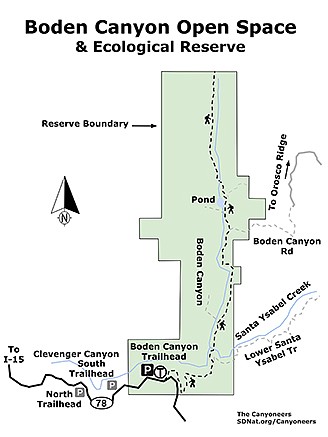
Boden Canyon Ecological Reserve map
BODEN CANYON OPEN SPACE & ECOLOGICAL RESERVE
This beautiful canyon has an abundance of great plant diversity.
Driving directions: From downtown San Diego, take I-15 north to exit 27 in Escondido. Go east on Via Rancho Parkway, which soon becomes Bear Valley Parkway. In less than a mile, make a right turn onto San Pasqual Road and continue for 3 miles to its intersection with Hwy 78. Go right on Hwy 78 and follow it east 7.9 miles to the Boden Canyon Trailhead, on the left. There is room for only about 4 cars at the Highway 78 trailhead. Groups of hikers should meet at one of the nearby Clevenger Canyon trailheads, where there is more parking, and consolidate to one or two vehicles before proceeding to the Boden Canyon Trailhead. The Clevenger Canyon South Trailhead is 5.3 miles, and the Clevenger Canyon North Trailhead is 5.8 miles from the Intersection of Hwy 78 and San Pasqual Road. Both have adequate vehicle parking, but no equestrian access. Hiking length: 7.2 miles out and back. Allow 3 hours. Difficulty: Moderate. 480 feet gain/loss. Open to hikers and leashed dogs. Called Guejito or Orosco on some maps, the Boden Canyon Truck Trail serves as access for emergency and official vehicles; however, it receives almost no motorized traffic on a day-to-day basis and is a very tranquil trail for hiking and observing nature. Best times are November to June. After June it is much warmer, so definitely make sure you have a good water supply. Take at least 2 liters of water per person and apply sunscreen. No facilities.
Here's something you might be interested in.
Hear water bubbling over boulders in Santa Ysabel Creek in Boden Canyon
This beautiful canyon has an abundance of great plant diversity.
Hear water bubbling over boulders in Santa Ysabel Creek in Boden Canyon
This beautiful canyon has an abundance of great plant diversity.
Looking into Boden Canyon and the Boden Canyon Truck Trail
From the staging area, follow the trail leading east. In 0.14 mile, it curves around a ridge and heads south into Clevenger Canyon, parallel to Hwy 78, but well below it. In about half a mile, the trail crosses an intermittent creek under the cover of huge coast live oaks, intermixed with arroyo willows and other riparian species.
After crossing the creek, the trail continues north on the other side of the canyon, gradually leaving the shady oaks behind. At 0.78 mile from the trailhead, you are back looking down into Boden Canyon, where, in winter and spring of years with high rainfall, you can hear water bubbling over boulders in Santa Ysabel Creek down below.
For the next 0.6 mile, the trail follows the contours of the creek, but stays well above it, crossing a hillside facing north to northwest. You can expect an abundance of native wildflowers beside the trail. Yellow and white pincushion, yellow bush penstemon, Chinese houses, blue-eyed grass, peninsular onion, red maids, golden yarrow, California chicory, deerweed, collar lupine, and the Parry larkspur. All are common in years with adequate rainfall. These lend a colorful accent to the many typical flowering chaparral plants: chamise, manzanita, sugar bush, laurel sumac, scrub oak, California sagebrush, buckwheat, black sage, mountain mahogany, and California lilacs.
Santa Ysabel Creek is 1.4 miles from the trailhead. In mid-May of 2019, the flowing water was about 20 meters (65 feet) wide and 10 centimeters (4 inches) deep above a bed of sand of varying depths. Those with low-rise boots will have wet feet, but it is safe to cross here.
Over the next 0.8 mile, the trail climbs a modest hillside, fully exposed to the afternoon sun. As a reward for your hard work in the hot sun, at 2.26 miles from the trailhead, you are back hiking through a cool forest of shady sycamore, coastal live oak, and Engelmann oak, with additional shade provided by blue elderberry trees and large laurel sumac semi-trees.
At 3.01 miles from the trailhead, the Boden Canyon Road (unsigned) joins the trail on the right. Following the road to the right would take you up to the Orosco Ridge. Instead, continue on the trail to the left.
At 3.25 miles, the trail enters an oak grassland, where scattered oaks are interspersed with native and non-native annual grasses, such as cheat grass, ripgut brome, foxtail brome, and wild oat, as well as an abundance of black mustard and filaree. In some places, the trail is overgrown with these annuals and difficult to follow.
Near an opening at 3.4 miles, a short trail leads off to the left, travels on top of an earthen dam, and ends at a concrete spillway. The dam creates a small pond that, even in this wet year, contains very little water. Previous visitors have described the pond as open water ringed with cattails. Currently there are few if any cattails, and the pond basin is choked with dead branches, possibly the former cattails, between which there are small puddles. While it’s not an especially attractive sight, it continues to be visited by waterfowl: winter visitors and wading birds such as the great egret.
At about 3.62 miles, the trail enters a dense oak forest in the creek bed that was flooded during winter storms. The trail is now covered with sand and gravel and is next to impossible to follow. At some place near here, it crosses to the west bank and continues for a short distance to the end of the preserve. According to the map, the trail will continue on into private lands, which must not be entered, making this a good place to turn around and go back the same way to your vehicle.
Boden Canyon Ecological Reserve map
BODEN CANYON OPEN SPACE & ECOLOGICAL RESERVE
This beautiful canyon has an abundance of great plant diversity.
Driving directions: From downtown San Diego, take I-15 north to exit 27 in Escondido. Go east on Via Rancho Parkway, which soon becomes Bear Valley Parkway. In less than a mile, make a right turn onto San Pasqual Road and continue for 3 miles to its intersection with Hwy 78. Go right on Hwy 78 and follow it east 7.9 miles to the Boden Canyon Trailhead, on the left. There is room for only about 4 cars at the Highway 78 trailhead. Groups of hikers should meet at one of the nearby Clevenger Canyon trailheads, where there is more parking, and consolidate to one or two vehicles before proceeding to the Boden Canyon Trailhead. The Clevenger Canyon South Trailhead is 5.3 miles, and the Clevenger Canyon North Trailhead is 5.8 miles from the Intersection of Hwy 78 and San Pasqual Road. Both have adequate vehicle parking, but no equestrian access. Hiking length: 7.2 miles out and back. Allow 3 hours. Difficulty: Moderate. 480 feet gain/loss. Open to hikers and leashed dogs. Called Guejito or Orosco on some maps, the Boden Canyon Truck Trail serves as access for emergency and official vehicles; however, it receives almost no motorized traffic on a day-to-day basis and is a very tranquil trail for hiking and observing nature. Best times are November to June. After June it is much warmer, so definitely make sure you have a good water supply. Take at least 2 liters of water per person and apply sunscreen. No facilities.
Comments