Here's something you might be interested in.
Ask a Hipster — Advice you didn't know you needed
Big Screen — Movie commentary
Blurt — Music's inside track
Booze News — San Diego spirits
Classical Music — Immortal beauty
Classifieds — Free and easy
Close to Home — What it’s like on the street where you live
Cover Stories — Front-page features
Drinks All Around — Bartenders' drink recipes
Excerpts — Literary and spiritual excerpts
Feast! — Food & drink reviews
Feature Stories — Local news & stories
Fishing Report — What’s getting hooked from ship and shore
From the Archives — Spotlight on the past
Golden Dreams — Talk of the town
The Gonzo Report — Making the musical scene, or at least reporting from it
Letters — Our inbox
Movies@Home — Local movie buffs share favorites
Movie Reviews — Our critics' picks and pans
Musician Interviews — Up close with local artists
Neighborhood News from Stringers — Hyperlocal news
News Ticker — News & politics
Obermeyer — San Diego politics illustrated
Outdoors — Weekly changes in flora and fauna
Overheard in San Diego — Eavesdropping illustrated
Poetry — The old and the new
Reader Travel — Travel section built by travelers
Reading — The hunt for intellectuals
Roam-O-Rama — SoCal's best hiking/biking trails
San Diego Beer — Inside San Diego suds
SD on the QT — Almost factual news
Sheep and Goats — Places of worship
Special Issues — The best of
Street Style — San Diego streets have style
Surf Diego — Real stories from those braving the waves
Theater — On stage in San Diego this week
Tin Fork — Silver spoon alternative
Under the Radar — Matt Potter's undercover work
Unforgettable — Long-ago San Diego
Unreal Estate — San Diego's priciest pads
Your Week — Daily event picks
Lower Santa Ysabel Trail: traverse a magnificent forest of large coast live oaks
Hike through shady oak woodlands and enjoy outstanding mountain views
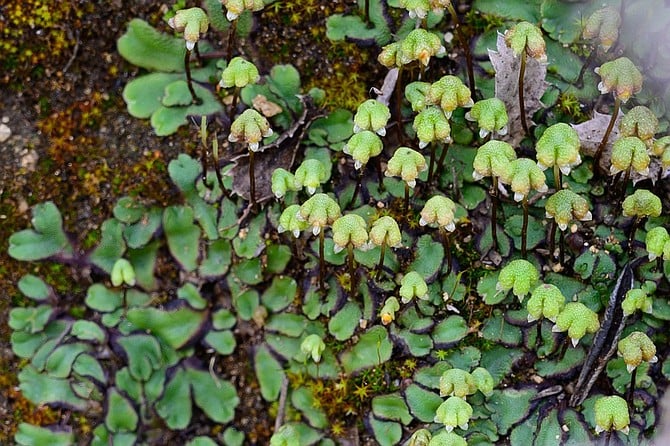
Look for liverworts with archegoniophores--the upright structure with a stem and a cap
This trail offers plenty of shade and interesting things to see and investigate nearly year round. You will find a continuously changing array of wildflowers and blooming shrubs and trees from November to late May — better in some years than others, but always ranging from very interesting to spectacularly beautiful.
The chief hazards are falls, poison oak, and rattlesnakes. Trekking poles are not needed but may be useful at times. Be sure to use sun protection and bring adequate drinking water (at least 2 liters). Although water may be found in springs or streams, the Forest Service leases the adjacent land for cattle grazing and any local surface water, if available, must be treated before drinking.
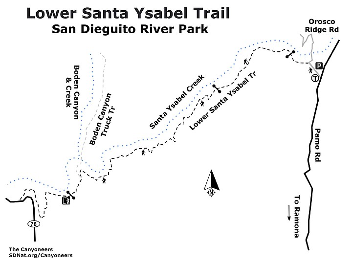
From the staging area, follow the signed trail leading west 0.14-mile to the Lower Santa Ysabel Trail. After passing through the gate near the bottom of the hill (be sure to close the gate to prevent cattle from escaping), the Orosco Ridge Road (currently closed to vehicles) crosses a bridge and leads off to the right, while the Lower Santa Ysabel Trail begins on the left.
Initially, the Lower Santa Ysabel Trail traverses a magnificent forest of large coast live oaks (Quercus agrifolia) and western sycamores (Platanus racemosa). Soon you pass around a locked gate and begin to ascend the former roadbed as it climbs up through the oak woodland with a chaparral-covered mountain rising above it. Keep an eye out and listen for sounds of woodpeckers in dead branches and snags. Both Nuttall’s and Downy Woodpeckers have been seen here.
After reaching an elevation of approximately 150 feet above the Santa Ysabel Creek bed, the trail undulates, then descends into a meadow-like riparian area nearer the creek. The trees in this area, mainly cottonwoods and willows, are often festooned with native grape vines (Vitis girdiana). In March of 2019, there were signs of extensive winter flooding, with piles of sand and debris on the banks and fast flowing water in the creek bed.
At about 1.3 miles from the staging area, you reach a locked metal gate. From this gate to trail’s-end at Boden Canyon, it has the character of a single-track foot path, with no evidence that vehicles have recently passed beyond that gate. Among the flowering shrubs found in this area are coast spice bush or bush-rue (Cneoridium dumosum) and Orcutt’s hairy ceanothus (C. oliganthus). Flowering vines have enraptured many shrubs and even small trees. Look for wild cucumber (Marah macrocarpa) and pipestem virgin’s bower (Clematis lasiantha).
Wildflowers may include yellow ranchers fiddleneck (Amsinckia intermedia), the intense blue Parry’s phacelia (P. parryi), red maids (Calandrinia menziesii), and baby blue eyes (Nemophila menziesii). Mosses and ferns are abundant on and near boulders and in other places with little direct sunlight. There are over 600 different species of moss in California, but you would need a microscope to identify them. Five different fern species are common here and are easier to identify, but it can still be a challenge to find them. Look carefully in shady, wet habitats and you may find not only ferns, but liverworts and horsetails as well.
In the spring, expect to find flowering sages: black (Salvia mellifera) and white (Salvia apiana), as well as fragrant sage (Salvia clevelandii), a pleasure for both the eyes and nose. Look for yuccas in bloom. Both chaparral candle (Hesperoyucca whipplei) and Mojave yucca (Yucca schidigera) are likely to have already initiated their inflorescences as spring flowers appear. These will rapidly shoot up over a few days as the weather warms.
A good place to turn around and go back is the locked gate 3.3 miles from the staging area and your parked vehicle. At this point you are still up on the side of the mountain, looking down into Santa Ysabel creek and Boden Canyon. It is a short hike down to the Boden Canyon truck trail and to the confluence of Boden Canyon and the Santa Ysabel creeks, but crossing the creek, which is necessary to go further up Boden Canyon, could be a problem. In mid-April 2019, the water in Santa Ysabel creek was still flowing deep and briskly over coarse sand of uncertain depth. Later in the season, it should not be a problem.
For information about extended or alternate hikes in this area, see the Roam-O-Rama column on the Lower Santa Ysabel Trail that ran on January 29, 2014: https://www.sandiegoreader.com/news/2014/jan/29/roam-lower-santa-ysabel-trail-boden-canyon/
Lower Santa Ysabel map
- LOWER SANTA YSABEL TRAIL
- Hike through shady oak woodlands and enjoy outstanding mountain views.
- Driving directions: (Ramona) From CA-67, go north on 7th Street for 0.2 mile. Turn right on Elm Street. Go 1.4 miles. Turn right on West Haverford Road. Go 0.1 mile. Turn left on Pamo Road and go 2.4 miles to the Pamo Valley Trail Staging Area on the left. The staging area is managed by the San Dieguito River Park and is now part of their Coast-to-Cactus Trail network, as are the Pamo Valley and the Lower Santa Ysabel Trails. Hiking length: 6.6 miles out and back. 480’ elevation change. Difficulty: Easy to moderate. Allow 3 hours. The hike traverses an old no-longer-used truck trail, designated Forest Route 12S04 (sometimes misidentified on some maps as 12504) by the Cleveland National Forest. Hikers, equestrians, leashed dogs, and non-motorized mountain bikes allowed. However, there are locked gates blocking access to motorized vehicles near the start and at intervals along the trail, so bikers and equestrians may have difficulty maneuvering.
Here's something you might be interested in.
Lower Santa Ysabel Trail: traverse a magnificent forest of large coast live oaks
Hike through shady oak woodlands and enjoy outstanding mountain views
Lower Santa Ysabel Trail: traverse a magnificent forest of large coast live oaks
Hike through shady oak woodlands and enjoy outstanding mountain views
Look for liverworts with archegoniophores--the upright structure with a stem and a cap
This trail offers plenty of shade and interesting things to see and investigate nearly year round. You will find a continuously changing array of wildflowers and blooming shrubs and trees from November to late May — better in some years than others, but always ranging from very interesting to spectacularly beautiful.
The chief hazards are falls, poison oak, and rattlesnakes. Trekking poles are not needed but may be useful at times. Be sure to use sun protection and bring adequate drinking water (at least 2 liters). Although water may be found in springs or streams, the Forest Service leases the adjacent land for cattle grazing and any local surface water, if available, must be treated before drinking.
From the staging area, follow the signed trail leading west 0.14-mile to the Lower Santa Ysabel Trail. After passing through the gate near the bottom of the hill (be sure to close the gate to prevent cattle from escaping), the Orosco Ridge Road (currently closed to vehicles) crosses a bridge and leads off to the right, while the Lower Santa Ysabel Trail begins on the left.
Initially, the Lower Santa Ysabel Trail traverses a magnificent forest of large coast live oaks (Quercus agrifolia) and western sycamores (Platanus racemosa). Soon you pass around a locked gate and begin to ascend the former roadbed as it climbs up through the oak woodland with a chaparral-covered mountain rising above it. Keep an eye out and listen for sounds of woodpeckers in dead branches and snags. Both Nuttall’s and Downy Woodpeckers have been seen here.
After reaching an elevation of approximately 150 feet above the Santa Ysabel Creek bed, the trail undulates, then descends into a meadow-like riparian area nearer the creek. The trees in this area, mainly cottonwoods and willows, are often festooned with native grape vines (Vitis girdiana). In March of 2019, there were signs of extensive winter flooding, with piles of sand and debris on the banks and fast flowing water in the creek bed.
At about 1.3 miles from the staging area, you reach a locked metal gate. From this gate to trail’s-end at Boden Canyon, it has the character of a single-track foot path, with no evidence that vehicles have recently passed beyond that gate. Among the flowering shrubs found in this area are coast spice bush or bush-rue (Cneoridium dumosum) and Orcutt’s hairy ceanothus (C. oliganthus). Flowering vines have enraptured many shrubs and even small trees. Look for wild cucumber (Marah macrocarpa) and pipestem virgin’s bower (Clematis lasiantha).
Wildflowers may include yellow ranchers fiddleneck (Amsinckia intermedia), the intense blue Parry’s phacelia (P. parryi), red maids (Calandrinia menziesii), and baby blue eyes (Nemophila menziesii). Mosses and ferns are abundant on and near boulders and in other places with little direct sunlight. There are over 600 different species of moss in California, but you would need a microscope to identify them. Five different fern species are common here and are easier to identify, but it can still be a challenge to find them. Look carefully in shady, wet habitats and you may find not only ferns, but liverworts and horsetails as well.
In the spring, expect to find flowering sages: black (Salvia mellifera) and white (Salvia apiana), as well as fragrant sage (Salvia clevelandii), a pleasure for both the eyes and nose. Look for yuccas in bloom. Both chaparral candle (Hesperoyucca whipplei) and Mojave yucca (Yucca schidigera) are likely to have already initiated their inflorescences as spring flowers appear. These will rapidly shoot up over a few days as the weather warms.
A good place to turn around and go back is the locked gate 3.3 miles from the staging area and your parked vehicle. At this point you are still up on the side of the mountain, looking down into Santa Ysabel creek and Boden Canyon. It is a short hike down to the Boden Canyon truck trail and to the confluence of Boden Canyon and the Santa Ysabel creeks, but crossing the creek, which is necessary to go further up Boden Canyon, could be a problem. In mid-April 2019, the water in Santa Ysabel creek was still flowing deep and briskly over coarse sand of uncertain depth. Later in the season, it should not be a problem.
For information about extended or alternate hikes in this area, see the Roam-O-Rama column on the Lower Santa Ysabel Trail that ran on January 29, 2014: https://www.sandiegoreader.com/news/2014/jan/29/roam-lower-santa-ysabel-trail-boden-canyon/
Lower Santa Ysabel map
- LOWER SANTA YSABEL TRAIL
- Hike through shady oak woodlands and enjoy outstanding mountain views.
- Driving directions: (Ramona) From CA-67, go north on 7th Street for 0.2 mile. Turn right on Elm Street. Go 1.4 miles. Turn right on West Haverford Road. Go 0.1 mile. Turn left on Pamo Road and go 2.4 miles to the Pamo Valley Trail Staging Area on the left. The staging area is managed by the San Dieguito River Park and is now part of their Coast-to-Cactus Trail network, as are the Pamo Valley and the Lower Santa Ysabel Trails. Hiking length: 6.6 miles out and back. 480’ elevation change. Difficulty: Easy to moderate. Allow 3 hours. The hike traverses an old no-longer-used truck trail, designated Forest Route 12S04 (sometimes misidentified on some maps as 12504) by the Cleveland National Forest. Hikers, equestrians, leashed dogs, and non-motorized mountain bikes allowed. However, there are locked gates blocking access to motorized vehicles near the start and at intervals along the trail, so bikers and equestrians may have difficulty maneuvering.