Here's something you might be interested in.
Ask a Hipster — Advice you didn't know you needed
Big Screen — Movie commentary
Blurt — Music's inside track
Booze News — San Diego spirits
Classical Music — Immortal beauty
Classifieds — Free and easy
Close to Home — What it’s like on the street where you live
Cover Stories — Front-page features
Drinks All Around — Bartenders' drink recipes
Excerpts — Literary and spiritual excerpts
Feast! — Food & drink reviews
Feature Stories — Local news & stories
Fishing Report — What’s getting hooked from ship and shore
From the Archives — Spotlight on the past
Golden Dreams — Talk of the town
The Gonzo Report — Making the musical scene, or at least reporting from it
Letters — Our inbox
Movies@Home — Local movie buffs share favorites
Movie Reviews — Our critics' picks and pans
Musician Interviews — Up close with local artists
Neighborhood News from Stringers — Hyperlocal news
News Ticker — News & politics
Obermeyer — San Diego politics illustrated
Outdoors — Weekly changes in flora and fauna
Overheard in San Diego — Eavesdropping illustrated
Poetry — The old and the new
Reader Travel — Travel section built by travelers
Reading — The hunt for intellectuals
Roam-O-Rama — SoCal's best hiking/biking trails
San Diego Beer — Inside San Diego suds
SD on the QT — Almost factual news
Sheep and Goats — Places of worship
Special Issues — The best of
Street Style — San Diego streets have style
Surf Diego — Real stories from those braving the waves
Theater — On stage in San Diego this week
Tin Fork — Silver spoon alternative
Under the Radar — Matt Potter's undercover work
Unforgettable — Long-ago San Diego
Unreal Estate — San Diego's priciest pads
Your Week — Daily event picks
The Upper Santa Ysabel Truck Trail on foot
Explore a trail that has most of the diverse habitats found in the county
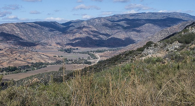
The view of Pamo Valley from the truck trail
Santa Ysabel Creek is a major tributary of the San Dieguito River. As it flows near Ramona, it is separated into upper and lower branches by the Pamo Valley. The Upper Santa Ysabel Truck Trail is a segment of the Coast to Crest Trail that will extend from Volcan Mountain to the ocean in Del Mar. The Upper Santa Ysabel Truck Trail follows Upper Santa Ysabel Creek from Pamo Valley to its intersection with Black Canyon Road near Sutherland Dam. The hike described can be extended from Black Canyon to Sutherland Dam, to complete this part of the Coast to Crest Trail.
This is a great cool season hike with expansive views and a chance to experience most of the diverse habitat types found in San Diego County. The hike can be done as a one-way trip with shuttle arrangement or as a much longer, all day out-and-back journey. It can be done from either end, but the description here assumes a Pamo Valley beginning.
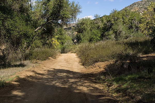
Entering canyon tributary
Try to arrive at the trailhead early in the morning to experience the spectacular descent into Pamo Valley from the Ramona plateau. Shortly after you pass the Ramona landfill, Pamo Valley Road begins a surprisingly sharp descent of more than 600 feet into the valley. The broad oak-forested valley floor extends 6 miles north and sits between Orosco Ridge to the west and Black Mountain to the east. In the 1880s, J.M. Woods bought land here with the idea of constructing a dam to provide water for agriculture. This idea was slow to die. In 1925, the City of San Diego bought property in the valley with the same idea. In 1950, the city obtained a permit to build a 264-foot-high dam that would have converted 4300 acres of Pamo Valley into a reservoir. However, in 1986 the Environmental Protection Agency ruled against the dam. The City of San Diego continues to own the valley, but it is now part of the San Dieguito River Park and is leased to cattle ranchers.
Start the hike where the Upper Santa Ysabel Truck Trail (FR12S07) begins from Pamo Valley Road. Although it is a truck trail, it gets relatively little vehicle traffic. The trail rises steadily about 700 feet up a ridge and through grassland first, then chaparral. At the crest of the ridge, Black Mountain Truck Trail splits off to the left while the Upper Santa Ysabel Truck Trail heads east, but it never reaches Santa Ysabel Creek. From here to Black Canyon the truck trail undulates but remains substantially above the creek. It is easy walking along the road and, if the day isn’t hot, you can enjoy the views down to Pamo Valley. A little further on, the trail passes into a tributary canyon where Engelmann’s oaks and western sycamores provide welcome shade and a good place to rest. At 2.3 miles there is a view down into Santa Ysabel Creek, where western cottonwoods, western sycamores, willows, and oaks line the stream. In the fall, the cottonwoods and sycamores turn a brilliant shade of yellow.
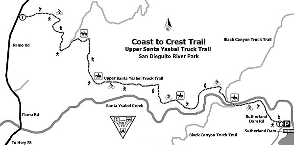
Coast to Crest Trail Map
At five miles is Black Canyon, with its oak forest with lush riparian vegetation. A campground was here until it was destroyed by a flash flood and never rebuilt. From here you can either end your hike or continue up the Sutherland Dam road, adding another 0.7 mile to your hike. You can arrange to be picked up at either place, but if you are doing an out-and-back, you are only halfway. Turn around and go back the way you came.
UPPER SANTA YSABEL TRUCK TRAIL FROM PAMO VALLEY
Distance from downtown San Diego: 50 miles. Allow 1 hour driving time. From CA-78 in Ramona, go west on Haverford Road for 0.8 mile. Continue onto Pamo Road, go 5.4 miles. Trailhead is at Forest Road 12S07, on the right.
Hiking length: 5, 8, 10, or 15 miles out-and-back and one-way options. Plan on 4–8 hours of hiking.
Difficulty: Moderately strenuous with 1000 feet to 1700 feet elevation gain/loss. Leashed dogs and bicycles permitted. High-clearance 4WD vehicles are essential if you plan to drive.
Here's something you might be interested in.
The Upper Santa Ysabel Truck Trail on foot
Explore a trail that has most of the diverse habitats found in the county
The Upper Santa Ysabel Truck Trail on foot
Explore a trail that has most of the diverse habitats found in the county
The view of Pamo Valley from the truck trail
Santa Ysabel Creek is a major tributary of the San Dieguito River. As it flows near Ramona, it is separated into upper and lower branches by the Pamo Valley. The Upper Santa Ysabel Truck Trail is a segment of the Coast to Crest Trail that will extend from Volcan Mountain to the ocean in Del Mar. The Upper Santa Ysabel Truck Trail follows Upper Santa Ysabel Creek from Pamo Valley to its intersection with Black Canyon Road near Sutherland Dam. The hike described can be extended from Black Canyon to Sutherland Dam, to complete this part of the Coast to Crest Trail.
This is a great cool season hike with expansive views and a chance to experience most of the diverse habitat types found in San Diego County. The hike can be done as a one-way trip with shuttle arrangement or as a much longer, all day out-and-back journey. It can be done from either end, but the description here assumes a Pamo Valley beginning.
Entering canyon tributary
Try to arrive at the trailhead early in the morning to experience the spectacular descent into Pamo Valley from the Ramona plateau. Shortly after you pass the Ramona landfill, Pamo Valley Road begins a surprisingly sharp descent of more than 600 feet into the valley. The broad oak-forested valley floor extends 6 miles north and sits between Orosco Ridge to the west and Black Mountain to the east. In the 1880s, J.M. Woods bought land here with the idea of constructing a dam to provide water for agriculture. This idea was slow to die. In 1925, the City of San Diego bought property in the valley with the same idea. In 1950, the city obtained a permit to build a 264-foot-high dam that would have converted 4300 acres of Pamo Valley into a reservoir. However, in 1986 the Environmental Protection Agency ruled against the dam. The City of San Diego continues to own the valley, but it is now part of the San Dieguito River Park and is leased to cattle ranchers.
Start the hike where the Upper Santa Ysabel Truck Trail (FR12S07) begins from Pamo Valley Road. Although it is a truck trail, it gets relatively little vehicle traffic. The trail rises steadily about 700 feet up a ridge and through grassland first, then chaparral. At the crest of the ridge, Black Mountain Truck Trail splits off to the left while the Upper Santa Ysabel Truck Trail heads east, but it never reaches Santa Ysabel Creek. From here to Black Canyon the truck trail undulates but remains substantially above the creek. It is easy walking along the road and, if the day isn’t hot, you can enjoy the views down to Pamo Valley. A little further on, the trail passes into a tributary canyon where Engelmann’s oaks and western sycamores provide welcome shade and a good place to rest. At 2.3 miles there is a view down into Santa Ysabel Creek, where western cottonwoods, western sycamores, willows, and oaks line the stream. In the fall, the cottonwoods and sycamores turn a brilliant shade of yellow.
Coast to Crest Trail Map
At five miles is Black Canyon, with its oak forest with lush riparian vegetation. A campground was here until it was destroyed by a flash flood and never rebuilt. From here you can either end your hike or continue up the Sutherland Dam road, adding another 0.7 mile to your hike. You can arrange to be picked up at either place, but if you are doing an out-and-back, you are only halfway. Turn around and go back the way you came.
UPPER SANTA YSABEL TRUCK TRAIL FROM PAMO VALLEY
Distance from downtown San Diego: 50 miles. Allow 1 hour driving time. From CA-78 in Ramona, go west on Haverford Road for 0.8 mile. Continue onto Pamo Road, go 5.4 miles. Trailhead is at Forest Road 12S07, on the right.
Hiking length: 5, 8, 10, or 15 miles out-and-back and one-way options. Plan on 4–8 hours of hiking.
Difficulty: Moderately strenuous with 1000 feet to 1700 feet elevation gain/loss. Leashed dogs and bicycles permitted. High-clearance 4WD vehicles are essential if you plan to drive.
Comments