Here's something you might be interested in.
Ask a Hipster — Advice you didn't know you needed
Big Screen — Movie commentary
Blurt — Music's inside track
Booze News — San Diego spirits
Classical Music — Immortal beauty
Classifieds — Free and easy
Close to Home — What it’s like on the street where you live
Cover Stories — Front-page features
Drinks All Around — Bartenders' drink recipes
Excerpts — Literary and spiritual excerpts
Feast! — Food & drink reviews
Feature Stories — Local news & stories
Fishing Report — What’s getting hooked from ship and shore
From the Archives — Spotlight on the past
Golden Dreams — Talk of the town
The Gonzo Report — Making the musical scene, or at least reporting from it
Letters — Our inbox
Movies@Home — Local movie buffs share favorites
Movie Reviews — Our critics' picks and pans
Musician Interviews — Up close with local artists
Neighborhood News from Stringers — Hyperlocal news
News Ticker — News & politics
Obermeyer — San Diego politics illustrated
Outdoors — Weekly changes in flora and fauna
Overheard in San Diego — Eavesdropping illustrated
Poetry — The old and the new
Reader Travel — Travel section built by travelers
Reading — The hunt for intellectuals
Roam-O-Rama — SoCal's best hiking/biking trails
San Diego Beer — Inside San Diego suds
SD on the QT — Almost factual news
Sheep and Goats — Places of worship
Special Issues — The best of
Street Style — San Diego streets have style
Surf Diego — Real stories from those braving the waves
Theater — On stage in San Diego this week
Tin Fork — Silver spoon alternative
Under the Radar — Matt Potter's undercover work
Unforgettable — Long-ago San Diego
Unreal Estate — San Diego's priciest pads
Your Week — Daily event picks
Black Canyon to Pamo Valley
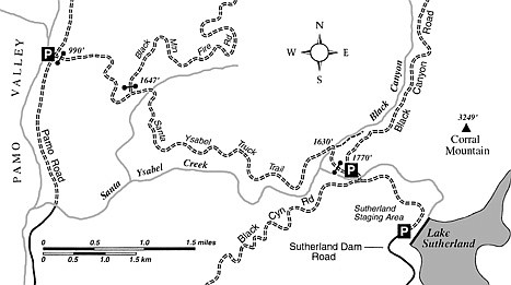
The easy-going, mostly descending (450 feet of elevation gain/1200 feet of elevation loss), east-to-west, one-way walk or mountain-bike ride on the Santa Ysabel Truck Trail near Ramona is fine for a cool day in February, but a potentially hot and sweaty affair later in the spring season. You’ll be following or paralleling a segment of the uncompleted Coast to Crest Trail, the long-distance, multi-use trail slated to link together the disparate natural habitats of the emerging San Dieguito River Park. The park itself stretches from the San Dieguito Lagoon at Del Mar to the crest of Volcan Mountain near Julian.
You’ll meander mostly downhill and sometimes uphill on shadeless south- and west-facing slopes blanketed in chamise and other drought-resistant forms of chaparral. The truck trail might be open to four-wheel-drive traffic, but if it is, you’ll likely see very few vehicles.
A one-way hike on the route would necessitate some kind of drop-off/pick-up arrangement, so here are the driving directions for each end:
EAST END: Drive east from Ramona on Highway 78 and turn north on Magnolia Avenue. Magnolia soon becomes Black Canyon Road and later becomes a narrow, twisting, graded dirt road. At 7.3 miles, you meet the road coming down from Sutherland Dam. Stay left, pass over the bridge spanning Santa Ysabel Creek, and continue 200 yards on Black Canyon Road to a junction with a gated, descending road — the Santa Ysabel Truck Trail. Start hiking at the top of this road.
WEST END: Drive north from Ramona’s town center on Seventh Street; it quickly becomes Elm Street. Continue on Elm to Haverford Road and turn right. A forced leftward bend in just 0.1 mile puts you northbound on Pamo Road. Continue down into the scenic and spacious Pamo Valley, where you cross Santa Ysabel Creek on a narrow concrete ford. Go an additional 1.3 miles north to the foot of the Santa Ysabel Truck Trail, on the right.
From the starting place, descend on Santa Ysabel Truck Trail to a spot where the road crosses Santa Ysabel Creek. Step over or wade across the Black Canyon stream by way of the concrete ford (but not if the water is too deep and dangerously swift, as after a recent downpour!). Gradual ups and downs and many twists and turns on the truck trail take you generally westward and farther and farther away from the bottom of the Santa Ysabel Creek gorge. At 3.3 miles, a live-oak-shaded ravine spreads a dense pool of shade across the trail. Shortly thereafter, on a ridgeline at 3.5 miles, a road comes down-ridge from the right. It leads upward toward Black Mountain, a former fire-lookout site nearly six miles away. Your course, though, continues downhill to Pamo Road, a crooked 1.5 miles away.
This article contains information about a publicly owned recreation or wilderness area. Trails and pathways are not necessarily marked. Conditions can change rapidly. Hikers should be properly equipped and have safety and navigational skills. The Reader and Jerry Schad assume no responsibility for any adverse experience.
Black Canyon to Pamo Valley
Enjoy a cool-weather hike-or-bike along the curling Santa Ysabel Truck Trail near Ramona.
Distance from downtown San Diego: about 40 miles
Hiking/biking length: 5.0 miles
Difficulty: Moderate
Here's something you might be interested in.
Black Canyon to Pamo Valley
Black Canyon to Pamo Valley
The easy-going, mostly descending (450 feet of elevation gain/1200 feet of elevation loss), east-to-west, one-way walk or mountain-bike ride on the Santa Ysabel Truck Trail near Ramona is fine for a cool day in February, but a potentially hot and sweaty affair later in the spring season. You’ll be following or paralleling a segment of the uncompleted Coast to Crest Trail, the long-distance, multi-use trail slated to link together the disparate natural habitats of the emerging San Dieguito River Park. The park itself stretches from the San Dieguito Lagoon at Del Mar to the crest of Volcan Mountain near Julian.
You’ll meander mostly downhill and sometimes uphill on shadeless south- and west-facing slopes blanketed in chamise and other drought-resistant forms of chaparral. The truck trail might be open to four-wheel-drive traffic, but if it is, you’ll likely see very few vehicles.
A one-way hike on the route would necessitate some kind of drop-off/pick-up arrangement, so here are the driving directions for each end:
EAST END: Drive east from Ramona on Highway 78 and turn north on Magnolia Avenue. Magnolia soon becomes Black Canyon Road and later becomes a narrow, twisting, graded dirt road. At 7.3 miles, you meet the road coming down from Sutherland Dam. Stay left, pass over the bridge spanning Santa Ysabel Creek, and continue 200 yards on Black Canyon Road to a junction with a gated, descending road — the Santa Ysabel Truck Trail. Start hiking at the top of this road.
WEST END: Drive north from Ramona’s town center on Seventh Street; it quickly becomes Elm Street. Continue on Elm to Haverford Road and turn right. A forced leftward bend in just 0.1 mile puts you northbound on Pamo Road. Continue down into the scenic and spacious Pamo Valley, where you cross Santa Ysabel Creek on a narrow concrete ford. Go an additional 1.3 miles north to the foot of the Santa Ysabel Truck Trail, on the right.
From the starting place, descend on Santa Ysabel Truck Trail to a spot where the road crosses Santa Ysabel Creek. Step over or wade across the Black Canyon stream by way of the concrete ford (but not if the water is too deep and dangerously swift, as after a recent downpour!). Gradual ups and downs and many twists and turns on the truck trail take you generally westward and farther and farther away from the bottom of the Santa Ysabel Creek gorge. At 3.3 miles, a live-oak-shaded ravine spreads a dense pool of shade across the trail. Shortly thereafter, on a ridgeline at 3.5 miles, a road comes down-ridge from the right. It leads upward toward Black Mountain, a former fire-lookout site nearly six miles away. Your course, though, continues downhill to Pamo Road, a crooked 1.5 miles away.
This article contains information about a publicly owned recreation or wilderness area. Trails and pathways are not necessarily marked. Conditions can change rapidly. Hikers should be properly equipped and have safety and navigational skills. The Reader and Jerry Schad assume no responsibility for any adverse experience.
Black Canyon to Pamo Valley
Enjoy a cool-weather hike-or-bike along the curling Santa Ysabel Truck Trail near Ramona.
Distance from downtown San Diego: about 40 miles
Hiking/biking length: 5.0 miles
Difficulty: Moderate