Here's something you might be interested in.
Ask a Hipster — Advice you didn't know you needed
Big Screen — Movie commentary
Blurt — Music's inside track
Booze News — San Diego spirits
Classical Music — Immortal beauty
Classifieds — Free and easy
Close to Home — What it’s like on the street where you live
Cover Stories — Front-page features
Drinks All Around — Bartenders' drink recipes
Excerpts — Literary and spiritual excerpts
Feast! — Food & drink reviews
Feature Stories — Local news & stories
Fishing Report — What’s getting hooked from ship and shore
From the Archives — Spotlight on the past
Golden Dreams — Talk of the town
The Gonzo Report — Making the musical scene, or at least reporting from it
Letters — Our inbox
Movies@Home — Local movie buffs share favorites
Movie Reviews — Our critics' picks and pans
Musician Interviews — Up close with local artists
Neighborhood News from Stringers — Hyperlocal news
News Ticker — News & politics
Obermeyer — San Diego politics illustrated
Outdoors — Weekly changes in flora and fauna
Overheard in San Diego — Eavesdropping illustrated
Poetry — The old and the new
Reader Travel — Travel section built by travelers
Reading — The hunt for intellectuals
Roam-O-Rama — SoCal's best hiking/biking trails
San Diego Beer — Inside San Diego suds
SD on the QT — Almost factual news
Sheep and Goats — Places of worship
Special Issues — The best of
Street Style — San Diego streets have style
Surf Diego — Real stories from those braving the waves
Theater — On stage in San Diego this week
Tin Fork — Silver spoon alternative
Under the Radar — Matt Potter's undercover work
Unforgettable — Long-ago San Diego
Unreal Estate — San Diego's priciest pads
Your Week — Daily event picks
Adventures above De Anza
There is no official trail up to the peak of Jacumba Mountain
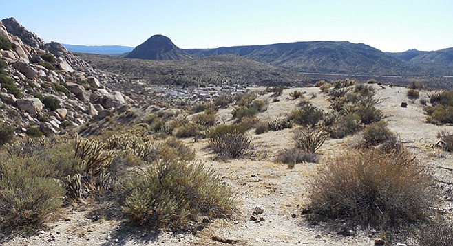
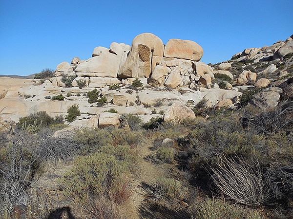
Approaching De Anza Resort
If you are someone who enjoys a little adventure through a bouldery desert landscape with few other people and you’re up for a bit of a navigational challenge, then this hike just may fit the bill. The route described below begins from the private resort of De Anza Springs and meanders through picturesque boulders on a series of trails and jeep roads before striking off cross-country and climbing up the steep rugged slopes of Jacumba Mountain. You will likely have this area to yourself as there is no official trail up to the peak in this somewhat desolate stretch of desert on the southern fringes of Anza-Borrego Desert State Park.
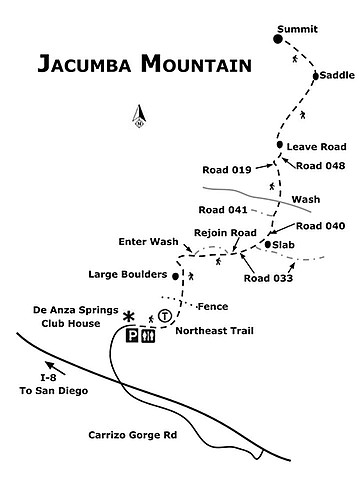
From the parking lot at the resort’s clubhouse, walk 0.2 mile on the dirt roads past residences to the northeast corner of the property and pick up the signed “Northeast Trail.” Follow this trail as it drops into a small wash and heads east, then climbs north out of the drainage and reaches a split at 0.3 mile. A neat row of rocks lines the path to the left, but keep right instead and follow the trail in a generally northward direction through gentle hills above the resort. Desert plants commonly seen here include Gander’s cholla, ephedra, flat-top buckwheat, matchweed, rabbitbrush, jojoba, and brittlebush. At 0.45 mile, cross through a fence marking the edge of the resort’s property and enter into the Jacumba National Cooperative Land and Wildlife Management Area.
Continuing on, keep an eye out for desert transition plants that may be in bloom including chaparral candle, a type of yucca with a tall stalk tipped with white bell-shaped flowers that are pollinated only by the California yucca moth. Look for the fragrant white sage, which had a variety of uses for the Native Americans, including the treatment of respiratory problems and the masking of human scent when the leaves were rubbed onto the skin prior to hunting. You’ll also pass by some thickets of the aptly-named catclaw, a scraggly shrub with short curved prickles that easily catch on clothing and skin. An occasional sugarbush is seen, distinguishable from many other shrubs in the desert as its leaves are a glossy dark green and flowers a pretty cream color in spring.
At 0.75 mile, reach some large boulders on your left, whose broad tops are tempting for taking a rest. At 0.9 mile, the trail passes over a rise and drops down and curves left. At 1 mile, reach another split – turn right (east) here on an old road, which reaches a wash and climbs up the other side, but leave the road and turn right up the wash as it provides an interesting bypass to this section of road and has more gradual elevation gain. While the wash contains a few dry waterfalls, they are relatively short and easy to surmount. Travel up this wash for about 0.25 mile until it curves left to rejoin the road, and then turn right. At about 1.6 miles from the start, reach a signed junction and turn left on Road 033, and shortly thereafter a left onto Road 040, where there is a concrete slab next to the road.
At 1.9 miles, you’ll reach a BLM sign about archaeological resources, where you can pause to read information about the area’s cultural significance. At just over 2 miles, keep right to stay on Road 040 (left is a dead end spur Road 041). Cross a wash at 2.25 miles, then in another 0.25 mile, veer right onto Road 019 followed by a left on Road 048 shortly thereafter. Finally, at just over 3 miles and situated between two small hills, reach a T-intersection and the place at which you will leave the roads behind and venture cross-country toward the rocky Jacumba Mountain looming ahead.
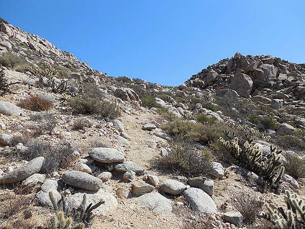
The use trail heads up to the summit ridge
Drop down from the road and pick the best way across the desert valley, generally heading in a north-northeast direction, aiming for the saddle between Jacumba Mountain (4,512’) and Peak 4,224’. There is another saddle southeast of Peak 4,224’, but take care to avoid hiking to this one by mistake as it will cause unnecessary elevation gain, loss, and regain. At 3.75 miles, reach the edge of the valley and begin the steep climb up to the saddle, finding a use trail marked by rock cairns. The route steadily switchbacks up the slope and at just over 4 miles, the trail ends at the saddle and there is a view down the other side of the ridge into the southeast portion of Anza-Borrego Desert State Park. Take a breather here as the crux of the climb is coming next.
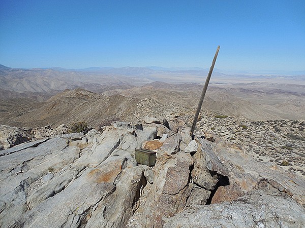
Jacumba Mountain: The summit, with register and view
Turning north, a jumble of boulders is visible above and these must be scrambled up or skirted around; neither option is particularly easy. There are steep drop-offs on both sides, so the exposure may give those with a fear of heights some cause for concern. However, this section is relatively short and once above the rocks, it is smooth sailing across the summit ridge where there is ample space to steer clear of the edges. The final walk across this peaceful, broad ridge affords views to both the east and west, and after bypassing a false summit and scrambling up a last airy section, reach the true high point at just over 4.8 miles from the start. A metal box contains a summit register to sign your name, and the surrounding rocks are comfortable enough for a leisurely break to soak in the views.
Across Carrizo Gorge to the west is Mt. Tule, the dark plateau to the south is Table Mountain, the Salton Sea is the distant strip of blue to the northeast, and to the north you can see far into Anza-Borrego Desert State Park with its many peaks, valleys, and badlands.
Huge boulders on the trail
After enjoying your time on the summit, carefully descend the rocks and head south back across the ridge. Use caution dropping down the steep section just above the saddle, as many of the rocks can be loose and footing may be unstable. Once at the saddle, turn right (southwest) and pick up the trail back to the desert floor. Turn south and make your way back to the road, then take care to choose all the correct turns at the road junctions. Soon the resort will come into view once again, and the navigational decisions are a little easier. Once back to your car there is no need to check out with the office; however, if a soak in a pool or refreshments at the restaurant sound good, these are available at the clubhouse. Inquiries about fees for such facilities and other recreational opportunities can be made at the front desk. Otherwise, once again respect the posted speed limit after your stay as you exit the property.
Driving Directions: (Jacumba Hot Springs) From I-8 east take exit No. 73 for Jacumba Hot Springs. Turn right (south) at the stop sign, and then an immediate right onto the frontage road that parallels the freeway. Follow this well-graded dirt road 2 miles west and then north, passing back under I-8, and reach the entrance gate for De Anza Springs clothing-optional resort. Use the intercom to buzz the office and ask permission to enter the property and hike the trails. Once inside the property, observe the 5 mph speed limit signs and drive to the office where you will leave your car and pay a small registration fee. The parking lot has room for several vehicles and restrooms are available inside the clubhouse. Office hours are from 9 a.m.-4 p.m. Monday-Thursday, and 8 a.m.-5 p.m. Friday-Sunday. Parking lot GPS: N32.65436, W116.18326.
Hiking length: 9.8 miles round trip. Allow 6.5 hours hiking time.
Difficulty: Strenuous, with areas of boulder scrambling. Elevation gain/loss up to 1,750 feet. The best time to visit this area is November through April as summer months can be quite hot and there is little shade. Navigation skills are required for numerous trail and road junctions, and the latter portion of the hike is cross-country travel.
Here's something you might be interested in.
Adventures above De Anza
There is no official trail up to the peak of Jacumba Mountain
Adventures above De Anza
There is no official trail up to the peak of Jacumba Mountain
Approaching De Anza Resort
If you are someone who enjoys a little adventure through a bouldery desert landscape with few other people and you’re up for a bit of a navigational challenge, then this hike just may fit the bill. The route described below begins from the private resort of De Anza Springs and meanders through picturesque boulders on a series of trails and jeep roads before striking off cross-country and climbing up the steep rugged slopes of Jacumba Mountain. You will likely have this area to yourself as there is no official trail up to the peak in this somewhat desolate stretch of desert on the southern fringes of Anza-Borrego Desert State Park.
From the parking lot at the resort’s clubhouse, walk 0.2 mile on the dirt roads past residences to the northeast corner of the property and pick up the signed “Northeast Trail.” Follow this trail as it drops into a small wash and heads east, then climbs north out of the drainage and reaches a split at 0.3 mile. A neat row of rocks lines the path to the left, but keep right instead and follow the trail in a generally northward direction through gentle hills above the resort. Desert plants commonly seen here include Gander’s cholla, ephedra, flat-top buckwheat, matchweed, rabbitbrush, jojoba, and brittlebush. At 0.45 mile, cross through a fence marking the edge of the resort’s property and enter into the Jacumba National Cooperative Land and Wildlife Management Area.
Continuing on, keep an eye out for desert transition plants that may be in bloom including chaparral candle, a type of yucca with a tall stalk tipped with white bell-shaped flowers that are pollinated only by the California yucca moth. Look for the fragrant white sage, which had a variety of uses for the Native Americans, including the treatment of respiratory problems and the masking of human scent when the leaves were rubbed onto the skin prior to hunting. You’ll also pass by some thickets of the aptly-named catclaw, a scraggly shrub with short curved prickles that easily catch on clothing and skin. An occasional sugarbush is seen, distinguishable from many other shrubs in the desert as its leaves are a glossy dark green and flowers a pretty cream color in spring.
At 0.75 mile, reach some large boulders on your left, whose broad tops are tempting for taking a rest. At 0.9 mile, the trail passes over a rise and drops down and curves left. At 1 mile, reach another split – turn right (east) here on an old road, which reaches a wash and climbs up the other side, but leave the road and turn right up the wash as it provides an interesting bypass to this section of road and has more gradual elevation gain. While the wash contains a few dry waterfalls, they are relatively short and easy to surmount. Travel up this wash for about 0.25 mile until it curves left to rejoin the road, and then turn right. At about 1.6 miles from the start, reach a signed junction and turn left on Road 033, and shortly thereafter a left onto Road 040, where there is a concrete slab next to the road.
At 1.9 miles, you’ll reach a BLM sign about archaeological resources, where you can pause to read information about the area’s cultural significance. At just over 2 miles, keep right to stay on Road 040 (left is a dead end spur Road 041). Cross a wash at 2.25 miles, then in another 0.25 mile, veer right onto Road 019 followed by a left on Road 048 shortly thereafter. Finally, at just over 3 miles and situated between two small hills, reach a T-intersection and the place at which you will leave the roads behind and venture cross-country toward the rocky Jacumba Mountain looming ahead.
The use trail heads up to the summit ridge
Drop down from the road and pick the best way across the desert valley, generally heading in a north-northeast direction, aiming for the saddle between Jacumba Mountain (4,512’) and Peak 4,224’. There is another saddle southeast of Peak 4,224’, but take care to avoid hiking to this one by mistake as it will cause unnecessary elevation gain, loss, and regain. At 3.75 miles, reach the edge of the valley and begin the steep climb up to the saddle, finding a use trail marked by rock cairns. The route steadily switchbacks up the slope and at just over 4 miles, the trail ends at the saddle and there is a view down the other side of the ridge into the southeast portion of Anza-Borrego Desert State Park. Take a breather here as the crux of the climb is coming next.
Jacumba Mountain: The summit, with register and view
Turning north, a jumble of boulders is visible above and these must be scrambled up or skirted around; neither option is particularly easy. There are steep drop-offs on both sides, so the exposure may give those with a fear of heights some cause for concern. However, this section is relatively short and once above the rocks, it is smooth sailing across the summit ridge where there is ample space to steer clear of the edges. The final walk across this peaceful, broad ridge affords views to both the east and west, and after bypassing a false summit and scrambling up a last airy section, reach the true high point at just over 4.8 miles from the start. A metal box contains a summit register to sign your name, and the surrounding rocks are comfortable enough for a leisurely break to soak in the views.
Across Carrizo Gorge to the west is Mt. Tule, the dark plateau to the south is Table Mountain, the Salton Sea is the distant strip of blue to the northeast, and to the north you can see far into Anza-Borrego Desert State Park with its many peaks, valleys, and badlands.
Huge boulders on the trail
After enjoying your time on the summit, carefully descend the rocks and head south back across the ridge. Use caution dropping down the steep section just above the saddle, as many of the rocks can be loose and footing may be unstable. Once at the saddle, turn right (southwest) and pick up the trail back to the desert floor. Turn south and make your way back to the road, then take care to choose all the correct turns at the road junctions. Soon the resort will come into view once again, and the navigational decisions are a little easier. Once back to your car there is no need to check out with the office; however, if a soak in a pool or refreshments at the restaurant sound good, these are available at the clubhouse. Inquiries about fees for such facilities and other recreational opportunities can be made at the front desk. Otherwise, once again respect the posted speed limit after your stay as you exit the property.
Driving Directions: (Jacumba Hot Springs) From I-8 east take exit No. 73 for Jacumba Hot Springs. Turn right (south) at the stop sign, and then an immediate right onto the frontage road that parallels the freeway. Follow this well-graded dirt road 2 miles west and then north, passing back under I-8, and reach the entrance gate for De Anza Springs clothing-optional resort. Use the intercom to buzz the office and ask permission to enter the property and hike the trails. Once inside the property, observe the 5 mph speed limit signs and drive to the office where you will leave your car and pay a small registration fee. The parking lot has room for several vehicles and restrooms are available inside the clubhouse. Office hours are from 9 a.m.-4 p.m. Monday-Thursday, and 8 a.m.-5 p.m. Friday-Sunday. Parking lot GPS: N32.65436, W116.18326.
Hiking length: 9.8 miles round trip. Allow 6.5 hours hiking time.
Difficulty: Strenuous, with areas of boulder scrambling. Elevation gain/loss up to 1,750 feet. The best time to visit this area is November through April as summer months can be quite hot and there is little shade. Navigation skills are required for numerous trail and road junctions, and the latter portion of the hike is cross-country travel.
Comments