Here's something you might be interested in.
Ask a Hipster — Advice you didn't know you needed
Big Screen — Movie commentary
Blurt — Music's inside track
Booze News — San Diego spirits
Classical Music — Immortal beauty
Classifieds — Free and easy
Close to Home — What it’s like on the street where you live
Cover Stories — Front-page features
Drinks All Around — Bartenders' drink recipes
Excerpts — Literary and spiritual excerpts
Feast! — Food & drink reviews
Feature Stories — Local news & stories
Fishing Report — What’s getting hooked from ship and shore
From the Archives — Spotlight on the past
Golden Dreams — Talk of the town
The Gonzo Report — Making the musical scene, or at least reporting from it
Letters — Our inbox
Movies@Home — Local movie buffs share favorites
Movie Reviews — Our critics' picks and pans
Musician Interviews — Up close with local artists
Neighborhood News from Stringers — Hyperlocal news
News Ticker — News & politics
Obermeyer — San Diego politics illustrated
Outdoors — Weekly changes in flora and fauna
Overheard in San Diego — Eavesdropping illustrated
Poetry — The old and the new
Reader Travel — Travel section built by travelers
Reading — The hunt for intellectuals
Roam-O-Rama — SoCal's best hiking/biking trails
San Diego Beer — Inside San Diego suds
SD on the QT — Almost factual news
Sheep and Goats — Places of worship
Special Issues — The best of
Street Style — San Diego streets have style
Surf Diego — Real stories from those braving the waves
Theater — On stage in San Diego this week
Tin Fork — Silver spoon alternative
Under the Radar — Matt Potter's undercover work
Unforgettable — Long-ago San Diego
Unreal Estate — San Diego's priciest pads
Your Week — Daily event picks
Trans-County—South Poway Trail
Hike an urban section of the Trans-County Trail
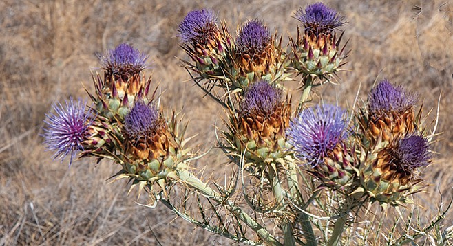
Artichoke thistle
The South Poway Trail is part of San Diego’s 110-mile Trans-County Trail, currently incomplete, that will eventually extend from the Anza Borrego Desert State Park to the Pacific Ocean near Torrey Pines State Natural Reserve. This relatively short segment of the Trans-County Trail will give you a taste of some of the various habitats and scenic vistas the trail provides. It is an easily followed dirt road with a number of hills to successively walk up, then down, but no challenging climbs or obstacles. It takes you through broad grasslands and coastal sage scrub, with some riparian habitats. In wet years, you can expect green fields with an abundance of wildflowers in winter and early spring. There is little shade and midsummer days can be hot. Even so, there is likely to be a cooling ocean breeze, particularly in the morning or late afternoon.
Leaving Community Road Underpass
Begin hiking up the broad, dirt trail leading from the Hill Country Trailhead as it goes up through grassland with abundant non-native annuals. Wild oat (Avena barbata) and cheat grass (Bromus tectorum) are especially common here. If you want to see green grassy fields, come in winter or early spring. By mid-March, these annual species will have completed their life cycles and the slopes will have turned brown. In non-drought years, you find scattered artichoke thistles (aka cardoon, Cynara cardunculus) with large purple inflorescenses. Though moderately invasive, cardoon can be quite attractive, but in the summer of this drought year 2018, many of these are dead. You also will find several large patches of the highly invasive non-native perennial bunch grass, known as fountain grass (Pennisetum setaceum). It has taken over, crowding out even the invasive annuals.
At about 0.25 mile from the trailhead, the trail drops down into an intermittent streambed, just below graffiti-covered check dam. In the wetland behind and in front of the check dam, you will find arroyo willow (Salix lasiolepsis), mule-fat (Baccharis salicifolia), tule (Schoenoplectus sp.) and southern cattail (Typha domingensis), as well as eucalyptus trees and tamarisk (Tamarix ramosissima), another invasive non-native with attractive flowers.
Trail passes through coastal sage habitat
After passing the check dam, the trail continues up the east side of the gully as it makes its way up the hillside. Some single-track trails come in to the main trail from below on the left. Ignore them. Soon the main trail forks, with a wide dirt trail on the left going down to the South Poway Trailhead, which you also should ignore. Continue on the trail to the right as it climbs to the top of the ridge. There you will find signs for both the South Poway Trail and the Trans-County Trail, with arrows pointing both east and west.
The main trail proceeds east along the ridge top, now passing through coastal sage scrub, with an abundance of flat-top buckwheat, laurel sumac, California everlasting, California sagebrush, coastal cholla, prickly-pear, and barrel cactus. The latter, Ferocactus viridescens, is rather rare elsewhere and considered a sensitive species, though common here. Most of the shrubby species were looking rather drought-stressed in July of 2018, but many of the laurel sumacs were in full flower.
As you continue along the ridge top, it gradually turns toward the northeast, pointing almost exactly at Mount Woodson. At the end of the ridge, the trail makes sharp right turn for the first of three switchbacks as it descends toward Community Drive. The vegetation covering this east-facing slope appears less stressed than that on the top of the ridge, but you also encounter more non-natives, particularly an abundance of black mustard.
After the third switchback, the trail is now aimed directly at Community Road. You pass through a short stretch of riparian growth and come to a 100-yard long tunnel under Community Drive. Though this is convenient for hikers, making it safer to cross the busy road on foot, the tunnel is primarily for equestrians, so that horse and rider can cross the road mounted.
The trail on the other side of the tunnel continues south around a riparian area for a few hundred yards, then turns east-northeast and again climbs up the slope, eventually taking you back to the ridge top. As you continue up the trail, you will encounter several single-track use trails leading off to both the left and right, a sign of much mountain biking activity. Once again at the top of the ridge, the main trail continues up then down three knolls, then comes to a sharp drop off at 2.75 miles from the Hill Country Trailhead. It is possible that the trail merely descends to businesses that line Stowe Drive from here. However, it is also possible that this is the current end of the South Poway Trail, which the City of Poway states will be extended to Sycamore Canyon Road at some point in the future. Because of this uncertainty, we recommend this as the turnaround point. Returning the way you came will give you a substantial 5.5-mile hike.
Canyoneers are San Diego Natural History Museum volunteers trained to lead interpretive nature walks that teach appreciation for the great outdoors. For a schedule of free public hikes, refer to the San Diego Natural History Museum website.
TRANS-COUNTY—SOUTH POWAY TRAIL
Hike an urban section of the Trans-County Trail
Driving directions: From I-15, take exit 17 for Scripps Poway Parkway and drive about 4 miles east, making a left turn onto Pomerado Road. Continue north on Pomerado Road for 0.6 mile, then turn right onto Poquito Street. In one short block, make another right onto Buckskin Trail (another city street). Follow it for about 0.3 mile and turn left as it merges with Hill Country Road. Follow Hill Country Road to the Hill Country Trailhead at its end. Parking is limited, but there are places to park along the street. Alternatively, you could park at the South Poway Trailhead, off Metate Lane, and start the hike from there, though it will be shorter by about a mile. The description given here assumes you will start at the Hill Country Trailhead.
Hiking length: 5.5 miles out-and-back. Allow 3 hours hiking time.
Difficulty: Moderate with elevation gain/loss of 800 feet. No facilities or water. Open year-round for hikers, leashed dogs, mountain bikers, and equestrians.
Here's something you might be interested in.
Trans-County—South Poway Trail
Hike an urban section of the Trans-County Trail
Trans-County—South Poway Trail
Hike an urban section of the Trans-County Trail
Artichoke thistle
The South Poway Trail is part of San Diego’s 110-mile Trans-County Trail, currently incomplete, that will eventually extend from the Anza Borrego Desert State Park to the Pacific Ocean near Torrey Pines State Natural Reserve. This relatively short segment of the Trans-County Trail will give you a taste of some of the various habitats and scenic vistas the trail provides. It is an easily followed dirt road with a number of hills to successively walk up, then down, but no challenging climbs or obstacles. It takes you through broad grasslands and coastal sage scrub, with some riparian habitats. In wet years, you can expect green fields with an abundance of wildflowers in winter and early spring. There is little shade and midsummer days can be hot. Even so, there is likely to be a cooling ocean breeze, particularly in the morning or late afternoon.
Leaving Community Road Underpass
Begin hiking up the broad, dirt trail leading from the Hill Country Trailhead as it goes up through grassland with abundant non-native annuals. Wild oat (Avena barbata) and cheat grass (Bromus tectorum) are especially common here. If you want to see green grassy fields, come in winter or early spring. By mid-March, these annual species will have completed their life cycles and the slopes will have turned brown. In non-drought years, you find scattered artichoke thistles (aka cardoon, Cynara cardunculus) with large purple inflorescenses. Though moderately invasive, cardoon can be quite attractive, but in the summer of this drought year 2018, many of these are dead. You also will find several large patches of the highly invasive non-native perennial bunch grass, known as fountain grass (Pennisetum setaceum). It has taken over, crowding out even the invasive annuals.
At about 0.25 mile from the trailhead, the trail drops down into an intermittent streambed, just below graffiti-covered check dam. In the wetland behind and in front of the check dam, you will find arroyo willow (Salix lasiolepsis), mule-fat (Baccharis salicifolia), tule (Schoenoplectus sp.) and southern cattail (Typha domingensis), as well as eucalyptus trees and tamarisk (Tamarix ramosissima), another invasive non-native with attractive flowers.
Trail passes through coastal sage habitat
After passing the check dam, the trail continues up the east side of the gully as it makes its way up the hillside. Some single-track trails come in to the main trail from below on the left. Ignore them. Soon the main trail forks, with a wide dirt trail on the left going down to the South Poway Trailhead, which you also should ignore. Continue on the trail to the right as it climbs to the top of the ridge. There you will find signs for both the South Poway Trail and the Trans-County Trail, with arrows pointing both east and west.
The main trail proceeds east along the ridge top, now passing through coastal sage scrub, with an abundance of flat-top buckwheat, laurel sumac, California everlasting, California sagebrush, coastal cholla, prickly-pear, and barrel cactus. The latter, Ferocactus viridescens, is rather rare elsewhere and considered a sensitive species, though common here. Most of the shrubby species were looking rather drought-stressed in July of 2018, but many of the laurel sumacs were in full flower.
As you continue along the ridge top, it gradually turns toward the northeast, pointing almost exactly at Mount Woodson. At the end of the ridge, the trail makes sharp right turn for the first of three switchbacks as it descends toward Community Drive. The vegetation covering this east-facing slope appears less stressed than that on the top of the ridge, but you also encounter more non-natives, particularly an abundance of black mustard.
After the third switchback, the trail is now aimed directly at Community Road. You pass through a short stretch of riparian growth and come to a 100-yard long tunnel under Community Drive. Though this is convenient for hikers, making it safer to cross the busy road on foot, the tunnel is primarily for equestrians, so that horse and rider can cross the road mounted.
The trail on the other side of the tunnel continues south around a riparian area for a few hundred yards, then turns east-northeast and again climbs up the slope, eventually taking you back to the ridge top. As you continue up the trail, you will encounter several single-track use trails leading off to both the left and right, a sign of much mountain biking activity. Once again at the top of the ridge, the main trail continues up then down three knolls, then comes to a sharp drop off at 2.75 miles from the Hill Country Trailhead. It is possible that the trail merely descends to businesses that line Stowe Drive from here. However, it is also possible that this is the current end of the South Poway Trail, which the City of Poway states will be extended to Sycamore Canyon Road at some point in the future. Because of this uncertainty, we recommend this as the turnaround point. Returning the way you came will give you a substantial 5.5-mile hike.
Canyoneers are San Diego Natural History Museum volunteers trained to lead interpretive nature walks that teach appreciation for the great outdoors. For a schedule of free public hikes, refer to the San Diego Natural History Museum website.
TRANS-COUNTY—SOUTH POWAY TRAIL
Hike an urban section of the Trans-County Trail
Driving directions: From I-15, take exit 17 for Scripps Poway Parkway and drive about 4 miles east, making a left turn onto Pomerado Road. Continue north on Pomerado Road for 0.6 mile, then turn right onto Poquito Street. In one short block, make another right onto Buckskin Trail (another city street). Follow it for about 0.3 mile and turn left as it merges with Hill Country Road. Follow Hill Country Road to the Hill Country Trailhead at its end. Parking is limited, but there are places to park along the street. Alternatively, you could park at the South Poway Trailhead, off Metate Lane, and start the hike from there, though it will be shorter by about a mile. The description given here assumes you will start at the Hill Country Trailhead.
Hiking length: 5.5 miles out-and-back. Allow 3 hours hiking time.
Difficulty: Moderate with elevation gain/loss of 800 feet. No facilities or water. Open year-round for hikers, leashed dogs, mountain bikers, and equestrians.
Comments