Here's something you might be interested in.
Ask a Hipster — Advice you didn't know you needed
Big Screen — Movie commentary
Blurt — Music's inside track
Booze News — San Diego spirits
Classical Music — Immortal beauty
Classifieds — Free and easy
Close to Home — What it’s like on the street where you live
Cover Stories — Front-page features
Drinks All Around — Bartenders' drink recipes
Excerpts — Literary and spiritual excerpts
Feast! — Food & drink reviews
Feature Stories — Local news & stories
Fishing Report — What’s getting hooked from ship and shore
From the Archives — Spotlight on the past
Golden Dreams — Talk of the town
The Gonzo Report — Making the musical scene, or at least reporting from it
Letters — Our inbox
Movies@Home — Local movie buffs share favorites
Movie Reviews — Our critics' picks and pans
Musician Interviews — Up close with local artists
Neighborhood News from Stringers — Hyperlocal news
News Ticker — News & politics
Obermeyer — San Diego politics illustrated
Outdoors — Weekly changes in flora and fauna
Overheard in San Diego — Eavesdropping illustrated
Poetry — The old and the new
Reader Travel — Travel section built by travelers
Reading — The hunt for intellectuals
Roam-O-Rama — SoCal's best hiking/biking trails
San Diego Beer — Inside San Diego suds
SD on the QT — Almost factual news
Sheep and Goats — Places of worship
Special Issues — The best of
Street Style — San Diego streets have style
Surf Diego — Real stories from those braving the waves
Theater — On stage in San Diego this week
Tin Fork — Silver spoon alternative
Under the Radar — Matt Potter's undercover work
Unforgettable — Long-ago San Diego
Unreal Estate — San Diego's priciest pads
Your Week — Daily event picks
Follow Peñasquitos Creek as it meanders through South Poway and Sabre Springs
Take time to enjoy views of Iron Mountain, Mount Woodson and an abundance of California native plants
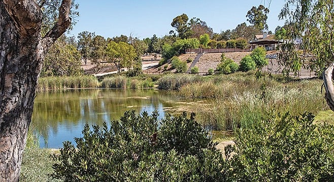
Look for birds at Poway Pond
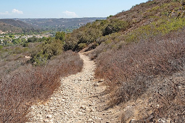
Take in the views hiking up the ridge trail
This is a segment of the 110-mile Trans-County Trail that follows Peñasquitos Creek as it meanders through South Poway and Sabre Springs. About half of the hike is an easy walk through coastal sage scrub and grassland habitat on the edge of shady live oak, sycamore, and willow riparian groves. You will also pass through scrub oak forests and an extensive hillside wetland called Spring Meadow. Rattlesnake and mountain lion encounters are a remote possibility; however, poison oak is abundant here. It is difficult to recognize when the plant is dormant, but even the fallen leaves are a hazard for sensitive persons. The best time of the year for this hike is after the rains come and the wildflowers begin to appear, usually from February through June, but there are things of interest along the trail at any time of the year.
Find the trail beginning at the northwest corner of Bette Bendixen Minipark. It is simply marked ”Trail” here, but on some maps it is labeled the Beeler Creek Trail. It is only 0.2 mile long, but takes you through beautiful coast live oaks, willows, and other riparian vegetation lining Beeler Creek, on your left. Poway Pond also will appear on your right.
When you reach the private Taylor Pond, turn left onto the South Poway Trail. Follow it down the hill, across Beeler Creek, then continue up the slope on the South Poway Trail onto degraded grassland. When you reach the shrubby coastal sage habitat, look for a trail splitting off to the right and take it. In another 0.1 mile, you will come to a hairpin turn. Take the trail to the right and follow it up to the top of the ridge. The trail here seems to be paved with cobblestones. These stones, composed of Poway rhyolite, were rounded by tumbling in a riverbed in what is now Sonora, Mexico, during the Eocene Epoch, 55 million years ago.
Upon reaching the crest of the ridge, look for the signpost bearing emblems for the South Poway Trail and the San Diego Trans-County Trail. There is also a marker with a web address for an organization supporting a Sea to Sea Trail. Take time to enjoy the views from here, particularly of the popular Poway peaks to the east: Iron Mountain and Mount Woodson.
When you are ready to move on, follow the road down the west-facing slope of the ridge. In 0.6 mile, you pass the Creekside Elementary School on your left, and continue along the trail to the bridge crossing Penasquitos Creek. The trail then descends down the creek bank, makes a 90 degree turn, and goes under the bridge and then onto the Peñasquitos Bike Path. The bike path is mostly up out of the Peñasquitos Creek riparian corridor, but it is close enough for you to enjoy shade from the many huge coast live oaks (Quercus agrifolia), California sycamores (Platanus racemosa), arroyo willows (Salix lasiolepsis) and non-natives including eucalyptus, Mexican fan palms, and tamarisk (Tamarix ramosissima). Native California wild grapes (Vitis girdiana), San Diego sedge (Carex spissa), California bulrush (Schoenoplectus californicus), and other sedges and rushes form a dense understory that usually hides the slowly flowing water in the creek.
Further west, the bike trail ends, but the San Diego Trans-County Trail continues, entering a patchwork of coastal sage scrub with abundant California buckwheat (Eriogonum fasciculatum), San Diego goldenbush (Isocoma menziesii), Broom baccharis (Baccharis sarothroides), and telegraph weed (Heterotheca grandiflora), all in flower in the fall. You can enjoy patches of dense scrub oak forest (Quercus berberidifolia) throughout the year. These oaks frequently reach over your head, almost forming a tunnel.
After you have hiked about 2 miles, the trail passes through the Spring Meadow wetland. Even in the summer, in the midst of a drought, you will find mud puddles and water flowing across the trail here. The water supports thickets of bull rushes and southern cattails, as well as sedges, rushes, and other wetland species, including the beautiful pink-flowered marsh fleabane (Pluchea odorata). The source of the water is not obvious. Perhaps it marks a geological fault running for about 0.1 mile parallel to or above the trail.
Cypress Hill, our destination and turn-around point, is now in sight. The Trans-County Trail continues around the north side of the hill, but as you begin to swing around the base of the hill, find a poorly maintained trail going steeply up the hill, on your left. After a 180-foot climb in 0.16 mile, you reach the hilltop where a large American flag flies. From here, you can see most of the trail you have covered and also the way back to your vehicle.
SABRE SPRINGS—SOUTH POWAY TRANS-COUNTY TRAIL
Enjoy an abundance of California native plants.
Sabre Springs South Poway Trans-County Trail map
Driving directions: From I-15, take exit 18, Poway Road. Go east on Poway Road 3 miles to Pomerado Road. Turn right on Pomerado Road. Drive another 0.4 mile to Old Pomerado Road, on your right. Follow Old Pomerado Road 0.3 mile to the Bette Bendixen Minipark, also on the right, and park on the street. This is the trailhead for the hike. Hiking length: 5.5 miles out-and-back. Allow 3 hours hiking time. Difficulty: Easy with an elevation gain/loss of 380 feet. The trail is open to hikers and leashed dogs, non-motorized bicycles, and equestrians.
Here's something you might be interested in.
Follow Peñasquitos Creek as it meanders through South Poway and Sabre Springs
Take time to enjoy views of Iron Mountain, Mount Woodson and an abundance of California native plants
Follow Peñasquitos Creek as it meanders through South Poway and Sabre Springs
Take time to enjoy views of Iron Mountain, Mount Woodson and an abundance of California native plants
Look for birds at Poway Pond
Take in the views hiking up the ridge trail
This is a segment of the 110-mile Trans-County Trail that follows Peñasquitos Creek as it meanders through South Poway and Sabre Springs. About half of the hike is an easy walk through coastal sage scrub and grassland habitat on the edge of shady live oak, sycamore, and willow riparian groves. You will also pass through scrub oak forests and an extensive hillside wetland called Spring Meadow. Rattlesnake and mountain lion encounters are a remote possibility; however, poison oak is abundant here. It is difficult to recognize when the plant is dormant, but even the fallen leaves are a hazard for sensitive persons. The best time of the year for this hike is after the rains come and the wildflowers begin to appear, usually from February through June, but there are things of interest along the trail at any time of the year.
Find the trail beginning at the northwest corner of Bette Bendixen Minipark. It is simply marked ”Trail” here, but on some maps it is labeled the Beeler Creek Trail. It is only 0.2 mile long, but takes you through beautiful coast live oaks, willows, and other riparian vegetation lining Beeler Creek, on your left. Poway Pond also will appear on your right.
When you reach the private Taylor Pond, turn left onto the South Poway Trail. Follow it down the hill, across Beeler Creek, then continue up the slope on the South Poway Trail onto degraded grassland. When you reach the shrubby coastal sage habitat, look for a trail splitting off to the right and take it. In another 0.1 mile, you will come to a hairpin turn. Take the trail to the right and follow it up to the top of the ridge. The trail here seems to be paved with cobblestones. These stones, composed of Poway rhyolite, were rounded by tumbling in a riverbed in what is now Sonora, Mexico, during the Eocene Epoch, 55 million years ago.
Upon reaching the crest of the ridge, look for the signpost bearing emblems for the South Poway Trail and the San Diego Trans-County Trail. There is also a marker with a web address for an organization supporting a Sea to Sea Trail. Take time to enjoy the views from here, particularly of the popular Poway peaks to the east: Iron Mountain and Mount Woodson.
When you are ready to move on, follow the road down the west-facing slope of the ridge. In 0.6 mile, you pass the Creekside Elementary School on your left, and continue along the trail to the bridge crossing Penasquitos Creek. The trail then descends down the creek bank, makes a 90 degree turn, and goes under the bridge and then onto the Peñasquitos Bike Path. The bike path is mostly up out of the Peñasquitos Creek riparian corridor, but it is close enough for you to enjoy shade from the many huge coast live oaks (Quercus agrifolia), California sycamores (Platanus racemosa), arroyo willows (Salix lasiolepsis) and non-natives including eucalyptus, Mexican fan palms, and tamarisk (Tamarix ramosissima). Native California wild grapes (Vitis girdiana), San Diego sedge (Carex spissa), California bulrush (Schoenoplectus californicus), and other sedges and rushes form a dense understory that usually hides the slowly flowing water in the creek.
Further west, the bike trail ends, but the San Diego Trans-County Trail continues, entering a patchwork of coastal sage scrub with abundant California buckwheat (Eriogonum fasciculatum), San Diego goldenbush (Isocoma menziesii), Broom baccharis (Baccharis sarothroides), and telegraph weed (Heterotheca grandiflora), all in flower in the fall. You can enjoy patches of dense scrub oak forest (Quercus berberidifolia) throughout the year. These oaks frequently reach over your head, almost forming a tunnel.
After you have hiked about 2 miles, the trail passes through the Spring Meadow wetland. Even in the summer, in the midst of a drought, you will find mud puddles and water flowing across the trail here. The water supports thickets of bull rushes and southern cattails, as well as sedges, rushes, and other wetland species, including the beautiful pink-flowered marsh fleabane (Pluchea odorata). The source of the water is not obvious. Perhaps it marks a geological fault running for about 0.1 mile parallel to or above the trail.
Cypress Hill, our destination and turn-around point, is now in sight. The Trans-County Trail continues around the north side of the hill, but as you begin to swing around the base of the hill, find a poorly maintained trail going steeply up the hill, on your left. After a 180-foot climb in 0.16 mile, you reach the hilltop where a large American flag flies. From here, you can see most of the trail you have covered and also the way back to your vehicle.
SABRE SPRINGS—SOUTH POWAY TRANS-COUNTY TRAIL
Enjoy an abundance of California native plants.
Sabre Springs South Poway Trans-County Trail map
Driving directions: From I-15, take exit 18, Poway Road. Go east on Poway Road 3 miles to Pomerado Road. Turn right on Pomerado Road. Drive another 0.4 mile to Old Pomerado Road, on your right. Follow Old Pomerado Road 0.3 mile to the Bette Bendixen Minipark, also on the right, and park on the street. This is the trailhead for the hike. Hiking length: 5.5 miles out-and-back. Allow 3 hours hiking time. Difficulty: Easy with an elevation gain/loss of 380 feet. The trail is open to hikers and leashed dogs, non-motorized bicycles, and equestrians.
Comments