Here's something you might be interested in.
Ask a Hipster — Advice you didn't know you needed
Big Screen — Movie commentary
Blurt — Music's inside track
Booze News — San Diego spirits
Classical Music — Immortal beauty
Classifieds — Free and easy
Close to Home — What it’s like on the street where you live
Cover Stories — Front-page features
Drinks All Around — Bartenders' drink recipes
Excerpts — Literary and spiritual excerpts
Feast! — Food & drink reviews
Feature Stories — Local news & stories
Fishing Report — What’s getting hooked from ship and shore
From the Archives — Spotlight on the past
Golden Dreams — Talk of the town
The Gonzo Report — Making the musical scene, or at least reporting from it
Letters — Our inbox
Movies@Home — Local movie buffs share favorites
Movie Reviews — Our critics' picks and pans
Musician Interviews — Up close with local artists
Neighborhood News from Stringers — Hyperlocal news
News Ticker — News & politics
Obermeyer — San Diego politics illustrated
Outdoors — Weekly changes in flora and fauna
Overheard in San Diego — Eavesdropping illustrated
Poetry — The old and the new
Reader Travel — Travel section built by travelers
Reading — The hunt for intellectuals
Roam-O-Rama — SoCal's best hiking/biking trails
San Diego Beer — Inside San Diego suds
SD on the QT — Almost factual news
Sheep and Goats — Places of worship
Special Issues — The best of
Street Style — San Diego streets have style
Surf Diego — Real stories from those braving the waves
Theater — On stage in San Diego this week
Tin Fork — Silver spoon alternative
Under the Radar — Matt Potter's undercover work
Unforgettable — Long-ago San Diego
Unreal Estate — San Diego's priciest pads
Your Week — Daily event picks
Rancho La Costa Preserve: an alternative to the busy Denk Mountain trails
View diverse habitats, seasonal changes, and outstanding vistas.
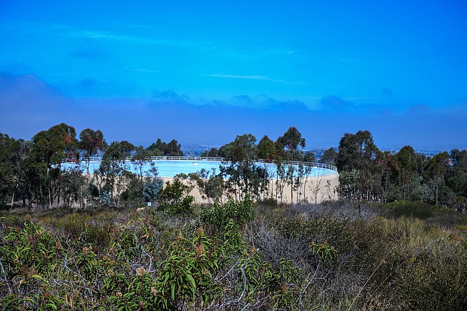
The watertank rises from coastal fog
The Rancho La Costa Preserve protects many native plant and animal species, some of which you may see on your visit. It also provides numerous scenic views. At nearly 1500 acres, it is one of the larger open space preserves in coastal San Diego County. Unfortunately, the preserve is broken up into numerous small sections by suburban developments, schools, large commercial complexes, and several high traffic roads. These interruptions make it a difficult landscape for wildlife, such as bobcats, mountain lions and coyotes, that range in search of food or mates. This fragmentation makes it difficult for hikers as well. Most trail segments tend to be short, and there are nearly 5 miles of crowded dirt biking trails on the south facing slope of Denk Mountain. The route put together here provides an alternative to the busy Denk Mountain trails. The good news is that the Preserve is actively working to acquire surrounding lands to fill in these gaps with some recent successes. See www.cnlm.org/portfolio_page/rancho-la-costa/ to learn more about the Preserve and how you can help support it.
From the trailhead on Sitio Salvia, start hiking on the dirt road leading northeast. In about 0.1 mile the trail branches. The trail to the left is signed “The Water Tank Trail.” Follow it 0.3 mile north to where it joins Denning Road, also signed as a continuation of the Water Tank Trail. Go right and follow this poorly paved road to mile 0.58, where the paved road curves left to the south side of the water tank. The trail, still signed Denning Road, leaves the paved road at this point and continues up the ridge as a wide dirt trail.
At mile 0.69, an unnamed dirt bike trail branches off to the left, leading down through the chaparral to Mahogany Park, a small children’s playground without facilities. Ignore it and continue straight up the ridge on Denning Road.
At mile 0.72, you reach the Switchback Trail, on your right, one of the main dirt biking trails of the preserve. From this point on, other biking trails will reach or cross Denning Road, all eventually leading down the coastal sage scrub-covered south-facing slope of Denk Mountain. These include other portions of the Switchback Trail, the Drop Down Trail, the Whiptail Loop, and the Horned Lizard Trail. Ignore all of these on this hike and continue on the rocky Denning Road. At mile 1.11, you are about 100 feet from the top of Denk Mountain, but Denning Road doesn’t go up to the top. At 1040 feet above sea level, Denk Mountain is the highest point in Carlsbad. It is worth taking some time to walk on up to the top of this hill-like “mountain.” The view west to Batiquitos Lagoon and out to the Pacific can be stunning, if atmospheric conditions are favorable. There is a picnic table here, set under a ramada. If you have come prepared for a picnic, enjoy it here. There is also a self-serve bicycle repair station, should you need it. If you detoured to catch the view from atop Denk Mountain, get back on Denning Road and continue your hike. At mile 2.22, Denning Road reaches San Elijo Road and the trail becomes progressively narrower as it descends the north side of the mountain.
Denning Trail will take you through the densest vegetation in this part of the preserve. In addition to the usual black sage, California sagebrush, chamise, California buckwheat, and lemonadeberry, thickets of laurel sumac, and holly-leaf redberry reach over eight feet in height. Interspersed with these small trees, you will find mission manzanita, blue elderberry, and scrub oaks. In summer the trail is bordered by flowering San Diego goldenbush as well as tall, flowering fennel, a non-native.
Upon reaching San Elijo Road, go about 100 feet northwest on the trail and find La Costa Oaks North Trail. It heads due west, following the powerlines. A short distance from the trail, you will pass Fallsview Park (not a source of drinking water or facilities), and continue on a broad, well maintained dirt path through hills almost devoid of native vegetation.
The La Costa Oaks North Trail crosses Dove Tail Drive and arrives at Mahogany Park 2.76 miles from Sitio Saliva. Shortly after passing the park, the trail splits. The one to the left goes up to the water tank. Stay on the trail to the right. After climbing a short steep hill, the route continues as a dirt trail, passing through coastal sage scrub-covered hills. At mile 3.17, you reach Avenida Soledad, a short distance from its intersection with Rancho Santa Fe Road. To safely cross Rancho Santa Fe Road, take the sidewalk on the south side of Avenida Soledad for two short blocks to its intersection with Rancho Santa Fe Road. Cross Rancho Santa Fe. Then follow the sidewalk along Rancho Santa Fe Road, south (up hill) a short distance to the continuation of La Costa Oaks Trail North, going west. At mile 3.57, find a narrow path leading off to the left, a beginning of the Bobcat Trail. Follow the Bobcat through the coastal sage scrub, where California sagebrush, black sage and lemonade berry are the dominant native species. However, there is an abundance of non-native invaders, especially black mustard, that form a skeletal thicket in summer, occasionally obscuring the natives. ,
At mile 3.84, the Bobcat Trail merges with the East Ridgeline Trail (ERL Trail). Go right on the ERL Trail, which gradually turns toward the west. At mile 4.03 you will come to an unnamed dirt bike trail leading off to the right. It is a loop trail that takes you about as close to an overlook of San Marcos Creek canyon as you can legally get. While you won’t be able to see water flowing in the creek, often you can hear it gently bubbling over rocks down below, even into early summer.
The trail rejoins the ERL Trail at 4.28 miles, and continues in a southerly direction. However, before continuing down the ERL Trail, go right to the end of the Powerline Trail. Although you can’t go into Box Canyon, from the end of Powerline Trail you get a grand view of this beautiful, rugged, canyon. You can be arrested and fined for going farther, but you are free to enjoy the wildest sight in Carlsbad from here.
Back on the ERL Trail, at 4.54 miles, the trail turns toward the east and enters a small swale. With the added moisture the swale supports a thicket of large shrubs and small trees, including broom baccharis, laurel sumac, and a few arroyo willows. At mile 4.73, the trail turns in a northerly direction, heading back toward its junction with the Bobcat Trail. There are more non-native, invasive plants along the trail here, including castor bean, as well as more fennel and black mustard, encroaching into the native coastal sage scrub habitat.
When you come to the Bobcat Trail on the right at 4.89 miles, take it. You have been on this trail earlier, but at mile 5.20, you intersect with the Old Santa Fe Road Trail (from here on, designated the OSFR Trail). The trailhead sign for the OSFR Trail states that it’s 1-mile long. Except for exercise, there is little reason to hike to its end at La Costa Drive, as the habitat becomes progressively more degraded and you are bombarded with traffic noise.
It is recommended that you continue south on the OSFR Trail to mile 5.6, then take the east-bound leg of the Ridgeline Trail to its junction with the sidewalk along Rancho Santa Fe Road. Follow it south to Camino Junipero Road, mile 6.0. Cross at the signal and follow, on foot, the route you took in your vehicle to arrive at the Sitio Salvia Trailhead, mile 6.4.
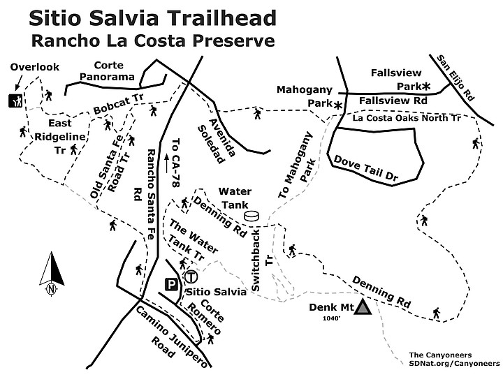
Sitio Salvia Trailhead map
SITIO SALVIA TRAILHEAD (Rancho La Costa Preserve)
View diverse habitats, seasonal changes, and outstanding vistas.
- Driving directions: From I-5, take the Leucadia exit and follow Leucadia east. In about 2 miles, Leucadia crosses El Camino Real and becomes Olivenhain Road, only to merge with Rancho Santa Fe Road in another mile. Continue 1.9 miles on Rancho Santa Fe Road, to Camino Junipero and turn right. In 0.2 mile, turn left on Corte Romero. Continue up Corte Romero to Sitio Salvia, turn right, and park on the right side of Sitio Salvia, near the trailhead. Hiking length: 6.4 miles. Allow 4 hours. Difficulty: Moderately easy, though long for some hikers. The trails are well-marked and easily followed. 780 feet elevation change. Mountain bikers, hikers, walkers, and leashed dogs allowed. No facilities. Bring plenty of water, and stay alert on the trail for bikes and animal and insect life. NOTE: This route requires crossing some very busy roads. Please do so at designated crosswalks, preferably ones with traffic signals.
Here's something you might be interested in.
Rancho La Costa Preserve: an alternative to the busy Denk Mountain trails
View diverse habitats, seasonal changes, and outstanding vistas.
Rancho La Costa Preserve: an alternative to the busy Denk Mountain trails
View diverse habitats, seasonal changes, and outstanding vistas.
The watertank rises from coastal fog
The Rancho La Costa Preserve protects many native plant and animal species, some of which you may see on your visit. It also provides numerous scenic views. At nearly 1500 acres, it is one of the larger open space preserves in coastal San Diego County. Unfortunately, the preserve is broken up into numerous small sections by suburban developments, schools, large commercial complexes, and several high traffic roads. These interruptions make it a difficult landscape for wildlife, such as bobcats, mountain lions and coyotes, that range in search of food or mates. This fragmentation makes it difficult for hikers as well. Most trail segments tend to be short, and there are nearly 5 miles of crowded dirt biking trails on the south facing slope of Denk Mountain. The route put together here provides an alternative to the busy Denk Mountain trails. The good news is that the Preserve is actively working to acquire surrounding lands to fill in these gaps with some recent successes. See www.cnlm.org/portfolio_page/rancho-la-costa/ to learn more about the Preserve and how you can help support it.
From the trailhead on Sitio Salvia, start hiking on the dirt road leading northeast. In about 0.1 mile the trail branches. The trail to the left is signed “The Water Tank Trail.” Follow it 0.3 mile north to where it joins Denning Road, also signed as a continuation of the Water Tank Trail. Go right and follow this poorly paved road to mile 0.58, where the paved road curves left to the south side of the water tank. The trail, still signed Denning Road, leaves the paved road at this point and continues up the ridge as a wide dirt trail.
At mile 0.69, an unnamed dirt bike trail branches off to the left, leading down through the chaparral to Mahogany Park, a small children’s playground without facilities. Ignore it and continue straight up the ridge on Denning Road.
At mile 0.72, you reach the Switchback Trail, on your right, one of the main dirt biking trails of the preserve. From this point on, other biking trails will reach or cross Denning Road, all eventually leading down the coastal sage scrub-covered south-facing slope of Denk Mountain. These include other portions of the Switchback Trail, the Drop Down Trail, the Whiptail Loop, and the Horned Lizard Trail. Ignore all of these on this hike and continue on the rocky Denning Road. At mile 1.11, you are about 100 feet from the top of Denk Mountain, but Denning Road doesn’t go up to the top. At 1040 feet above sea level, Denk Mountain is the highest point in Carlsbad. It is worth taking some time to walk on up to the top of this hill-like “mountain.” The view west to Batiquitos Lagoon and out to the Pacific can be stunning, if atmospheric conditions are favorable. There is a picnic table here, set under a ramada. If you have come prepared for a picnic, enjoy it here. There is also a self-serve bicycle repair station, should you need it. If you detoured to catch the view from atop Denk Mountain, get back on Denning Road and continue your hike. At mile 2.22, Denning Road reaches San Elijo Road and the trail becomes progressively narrower as it descends the north side of the mountain.
Denning Trail will take you through the densest vegetation in this part of the preserve. In addition to the usual black sage, California sagebrush, chamise, California buckwheat, and lemonadeberry, thickets of laurel sumac, and holly-leaf redberry reach over eight feet in height. Interspersed with these small trees, you will find mission manzanita, blue elderberry, and scrub oaks. In summer the trail is bordered by flowering San Diego goldenbush as well as tall, flowering fennel, a non-native.
Upon reaching San Elijo Road, go about 100 feet northwest on the trail and find La Costa Oaks North Trail. It heads due west, following the powerlines. A short distance from the trail, you will pass Fallsview Park (not a source of drinking water or facilities), and continue on a broad, well maintained dirt path through hills almost devoid of native vegetation.
The La Costa Oaks North Trail crosses Dove Tail Drive and arrives at Mahogany Park 2.76 miles from Sitio Saliva. Shortly after passing the park, the trail splits. The one to the left goes up to the water tank. Stay on the trail to the right. After climbing a short steep hill, the route continues as a dirt trail, passing through coastal sage scrub-covered hills. At mile 3.17, you reach Avenida Soledad, a short distance from its intersection with Rancho Santa Fe Road. To safely cross Rancho Santa Fe Road, take the sidewalk on the south side of Avenida Soledad for two short blocks to its intersection with Rancho Santa Fe Road. Cross Rancho Santa Fe. Then follow the sidewalk along Rancho Santa Fe Road, south (up hill) a short distance to the continuation of La Costa Oaks Trail North, going west. At mile 3.57, find a narrow path leading off to the left, a beginning of the Bobcat Trail. Follow the Bobcat through the coastal sage scrub, where California sagebrush, black sage and lemonade berry are the dominant native species. However, there is an abundance of non-native invaders, especially black mustard, that form a skeletal thicket in summer, occasionally obscuring the natives. ,
At mile 3.84, the Bobcat Trail merges with the East Ridgeline Trail (ERL Trail). Go right on the ERL Trail, which gradually turns toward the west. At mile 4.03 you will come to an unnamed dirt bike trail leading off to the right. It is a loop trail that takes you about as close to an overlook of San Marcos Creek canyon as you can legally get. While you won’t be able to see water flowing in the creek, often you can hear it gently bubbling over rocks down below, even into early summer.
The trail rejoins the ERL Trail at 4.28 miles, and continues in a southerly direction. However, before continuing down the ERL Trail, go right to the end of the Powerline Trail. Although you can’t go into Box Canyon, from the end of Powerline Trail you get a grand view of this beautiful, rugged, canyon. You can be arrested and fined for going farther, but you are free to enjoy the wildest sight in Carlsbad from here.
Back on the ERL Trail, at 4.54 miles, the trail turns toward the east and enters a small swale. With the added moisture the swale supports a thicket of large shrubs and small trees, including broom baccharis, laurel sumac, and a few arroyo willows. At mile 4.73, the trail turns in a northerly direction, heading back toward its junction with the Bobcat Trail. There are more non-native, invasive plants along the trail here, including castor bean, as well as more fennel and black mustard, encroaching into the native coastal sage scrub habitat.
When you come to the Bobcat Trail on the right at 4.89 miles, take it. You have been on this trail earlier, but at mile 5.20, you intersect with the Old Santa Fe Road Trail (from here on, designated the OSFR Trail). The trailhead sign for the OSFR Trail states that it’s 1-mile long. Except for exercise, there is little reason to hike to its end at La Costa Drive, as the habitat becomes progressively more degraded and you are bombarded with traffic noise.
It is recommended that you continue south on the OSFR Trail to mile 5.6, then take the east-bound leg of the Ridgeline Trail to its junction with the sidewalk along Rancho Santa Fe Road. Follow it south to Camino Junipero Road, mile 6.0. Cross at the signal and follow, on foot, the route you took in your vehicle to arrive at the Sitio Salvia Trailhead, mile 6.4.
Sitio Salvia Trailhead map
SITIO SALVIA TRAILHEAD (Rancho La Costa Preserve)
View diverse habitats, seasonal changes, and outstanding vistas.
- Driving directions: From I-5, take the Leucadia exit and follow Leucadia east. In about 2 miles, Leucadia crosses El Camino Real and becomes Olivenhain Road, only to merge with Rancho Santa Fe Road in another mile. Continue 1.9 miles on Rancho Santa Fe Road, to Camino Junipero and turn right. In 0.2 mile, turn left on Corte Romero. Continue up Corte Romero to Sitio Salvia, turn right, and park on the right side of Sitio Salvia, near the trailhead. Hiking length: 6.4 miles. Allow 4 hours. Difficulty: Moderately easy, though long for some hikers. The trails are well-marked and easily followed. 780 feet elevation change. Mountain bikers, hikers, walkers, and leashed dogs allowed. No facilities. Bring plenty of water, and stay alert on the trail for bikes and animal and insect life. NOTE: This route requires crossing some very busy roads. Please do so at designated crosswalks, preferably ones with traffic signals.