Here's something you might be interested in.
Ask a Hipster — Advice you didn't know you needed
Big Screen — Movie commentary
Blurt — Music's inside track
Booze News — San Diego spirits
Classical Music — Immortal beauty
Classifieds — Free and easy
Close to Home — What it’s like on the street where you live
Cover Stories — Front-page features
Drinks All Around — Bartenders' drink recipes
Excerpts — Literary and spiritual excerpts
Feast! — Food & drink reviews
Feature Stories — Local news & stories
Fishing Report — What’s getting hooked from ship and shore
From the Archives — Spotlight on the past
Golden Dreams — Talk of the town
The Gonzo Report — Making the musical scene, or at least reporting from it
Letters — Our inbox
Movies@Home — Local movie buffs share favorites
Movie Reviews — Our critics' picks and pans
Musician Interviews — Up close with local artists
Neighborhood News from Stringers — Hyperlocal news
News Ticker — News & politics
Obermeyer — San Diego politics illustrated
Outdoors — Weekly changes in flora and fauna
Overheard in San Diego — Eavesdropping illustrated
Poetry — The old and the new
Reader Travel — Travel section built by travelers
Reading — The hunt for intellectuals
Roam-O-Rama — SoCal's best hiking/biking trails
San Diego Beer — Inside San Diego suds
SD on the QT — Almost factual news
Sheep and Goats — Places of worship
Special Issues — The best of
Street Style — San Diego streets have style
Surf Diego — Real stories from those braving the waves
Theater — On stage in San Diego this week
Tin Fork — Silver spoon alternative
Under the Radar — Matt Potter's undercover work
Unforgettable — Long-ago San Diego
Unreal Estate — San Diego's priciest pads
Your Week — Daily event picks
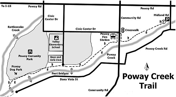
Poway Creek — the ultimate suburban trail
Amphitheater, fire station, Royal Estates, Boys & Girls Club, softball field
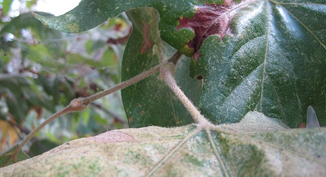
Sycamore trees with their large palmate leaves surrounding the new bud.
Poway Creek Trail is number 27 of the 30 trails listed in the Poway Trails and Open Space System guide. The trail is just north of Poway Creek with numerous native riparian plants plus non-natives that grow along the mostly shaded trail. The initial path from Midland Road transitions from concrete to decomposed granitic soil as you walk behind the shopping center. It passes by a small amphitheater and ends at Community Road.
The initial path transitions from concrete to decomposed granitic soil.
There are a number of different types of pine trees along this section, plus native cattails growing in the creek for the entire distance of this walk.
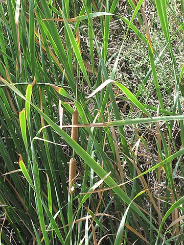
Native cattails grow in the creek for the entire distance.
Listen for the one-second call of the male red-winged blackbirds. Look for a dark black bird with scarlet and yellow shoulder patches found mostly on high perches with the females found at the lower elevations camouflaged by their dark brown streaked bodies that are a lighter brown on the breast. The females may have a whitish eyebrow.
The trail is just north of Poway Creek.
Turn right (north) to the corner of Community Road and Civic Center Drive and cross at the signal, then go south on Community Road, past the fire station before turning right to continue on the Poway Creek Trail going west.
Notice the sycamore trees (Platanus racemosa) with their large palmate leaves surrounding the new buds with the base of the stalk. The fruit is a ball-shaped head hanging on a pendant. Other riparian plants seen in the area are western cottonwood and willow. Just before Bowron Road is a bridge that crosses over the creek to the Poway Royal Estates. Walk to the center of the bridge for a view of the creek through the plants before returning to Poway Creek Trail to continue west (left).
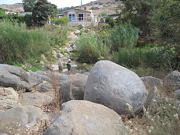
Pass by the Boys & Girls Club building and a softball field to a rocky section that spans Poway Creek. In this area, there is the low-growing Himalayan blackberry, an invasive plant well armed with thorns and prickles. There is also marsh fleabane, a native herb growing erect with a large cluster of pinkish-purple or magenta flower heads.
Return to the trail and continue west (left) past the dog park that is divided into small-, medium-, and large-breed areas. At the Y-intersection, continue left to another bridge where you can turn around after viewing the creek and the merge of Rattlesnake Creek into Poway Creek, or cross the bridge to the end of the trail at Soule Street before turning back to your vehicle.
Options are to turn north at the Y-intersection to view Rattlesnake Creek for a short distance to another bridge that crosses to Buckley Street, or walk on a combination of sidewalks and parking lots to the end of this section of the creek just north of Poway Skate Park and Civic Center Road. Alternatively, continue west on Soule Street to another bridge crossing to the Carriage/Oak Knoll Road intersection.
Distance from downtown San Diego: 22 miles (Poway). Allow 30 minutes driving time. From Highway 163N, merge onto I-15N then take exit 18 Poway Road. Turn right (east) at the signal. Continue on Poway Road for 4.1 miles, then turn right (south) onto Midland Road for a short distance. The path starts at the southeast corner of the shopping-center parking lot at 13066 Midland Road.
Hiking length: Approximately 1.85 miles out and back.
Difficulty: Easy, with less than 100 feet of elevation gain/loss. Horses are allowed on the urban trail along Poway Creek behind City Hall and Creekside Plaza. Bicycles and dogs on leashes allowed from Midland Road to destination. Open sunrise to sunset.
Here's something you might be interested in.
Poway Creek — the ultimate suburban trail
Amphitheater, fire station, Royal Estates, Boys & Girls Club, softball field
Poway Creek — the ultimate suburban trail
Amphitheater, fire station, Royal Estates, Boys & Girls Club, softball field
Sycamore trees with their large palmate leaves surrounding the new bud.
Poway Creek Trail is number 27 of the 30 trails listed in the Poway Trails and Open Space System guide. The trail is just north of Poway Creek with numerous native riparian plants plus non-natives that grow along the mostly shaded trail. The initial path from Midland Road transitions from concrete to decomposed granitic soil as you walk behind the shopping center. It passes by a small amphitheater and ends at Community Road.
The initial path transitions from concrete to decomposed granitic soil.
There are a number of different types of pine trees along this section, plus native cattails growing in the creek for the entire distance of this walk.
Native cattails grow in the creek for the entire distance.
Listen for the one-second call of the male red-winged blackbirds. Look for a dark black bird with scarlet and yellow shoulder patches found mostly on high perches with the females found at the lower elevations camouflaged by their dark brown streaked bodies that are a lighter brown on the breast. The females may have a whitish eyebrow.
The trail is just north of Poway Creek.
Turn right (north) to the corner of Community Road and Civic Center Drive and cross at the signal, then go south on Community Road, past the fire station before turning right to continue on the Poway Creek Trail going west.
Notice the sycamore trees (Platanus racemosa) with their large palmate leaves surrounding the new buds with the base of the stalk. The fruit is a ball-shaped head hanging on a pendant. Other riparian plants seen in the area are western cottonwood and willow. Just before Bowron Road is a bridge that crosses over the creek to the Poway Royal Estates. Walk to the center of the bridge for a view of the creek through the plants before returning to Poway Creek Trail to continue west (left).
Pass by the Boys & Girls Club building and a softball field to a rocky section that spans Poway Creek. In this area, there is the low-growing Himalayan blackberry, an invasive plant well armed with thorns and prickles. There is also marsh fleabane, a native herb growing erect with a large cluster of pinkish-purple or magenta flower heads.
Return to the trail and continue west (left) past the dog park that is divided into small-, medium-, and large-breed areas. At the Y-intersection, continue left to another bridge where you can turn around after viewing the creek and the merge of Rattlesnake Creek into Poway Creek, or cross the bridge to the end of the trail at Soule Street before turning back to your vehicle.
Options are to turn north at the Y-intersection to view Rattlesnake Creek for a short distance to another bridge that crosses to Buckley Street, or walk on a combination of sidewalks and parking lots to the end of this section of the creek just north of Poway Skate Park and Civic Center Road. Alternatively, continue west on Soule Street to another bridge crossing to the Carriage/Oak Knoll Road intersection.
Distance from downtown San Diego: 22 miles (Poway). Allow 30 minutes driving time. From Highway 163N, merge onto I-15N then take exit 18 Poway Road. Turn right (east) at the signal. Continue on Poway Road for 4.1 miles, then turn right (south) onto Midland Road for a short distance. The path starts at the southeast corner of the shopping-center parking lot at 13066 Midland Road.
Hiking length: Approximately 1.85 miles out and back.
Difficulty: Easy, with less than 100 feet of elevation gain/loss. Horses are allowed on the urban trail along Poway Creek behind City Hall and Creekside Plaza. Bicycles and dogs on leashes allowed from Midland Road to destination. Open sunrise to sunset.
Comments