Here's something you might be interested in.
Ask a Hipster — Advice you didn't know you needed
Big Screen — Movie commentary
Blurt — Music's inside track
Booze News — San Diego spirits
Classical Music — Immortal beauty
Classifieds — Free and easy
Close to Home — What it’s like on the street where you live
Cover Stories — Front-page features
Drinks All Around — Bartenders' drink recipes
Excerpts — Literary and spiritual excerpts
Feast! — Food & drink reviews
Feature Stories — Local news & stories
Fishing Report — What’s getting hooked from ship and shore
From the Archives — Spotlight on the past
Golden Dreams — Talk of the town
The Gonzo Report — Making the musical scene, or at least reporting from it
Letters — Our inbox
Movies@Home — Local movie buffs share favorites
Movie Reviews — Our critics' picks and pans
Musician Interviews — Up close with local artists
Neighborhood News from Stringers — Hyperlocal news
News Ticker — News & politics
Obermeyer — San Diego politics illustrated
Outdoors — Weekly changes in flora and fauna
Overheard in San Diego — Eavesdropping illustrated
Poetry — The old and the new
Reader Travel — Travel section built by travelers
Reading — The hunt for intellectuals
Roam-O-Rama — SoCal's best hiking/biking trails
San Diego Beer — Inside San Diego suds
SD on the QT — Almost factual news
Sheep and Goats — Places of worship
Special Issues — The best of
Street Style — San Diego streets have style
Surf Diego — Real stories from those braving the waves
Theater — On stage in San Diego this week
Tin Fork — Silver spoon alternative
Under the Radar — Matt Potter's undercover work
Unforgettable — Long-ago San Diego
Unreal Estate — San Diego's priciest pads
Your Week — Daily event picks
Marston Canyon: follow a creek bed from Richmond Street to CA-163
Discover a quiet urban canyon connected to the Balboa Park trails network.
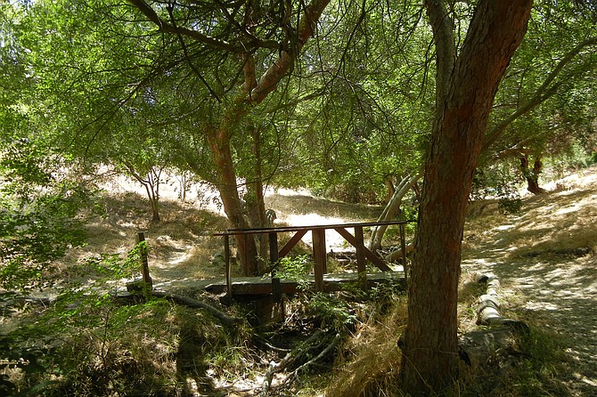
A wooden bridge is under a shady grove of Chinese elms
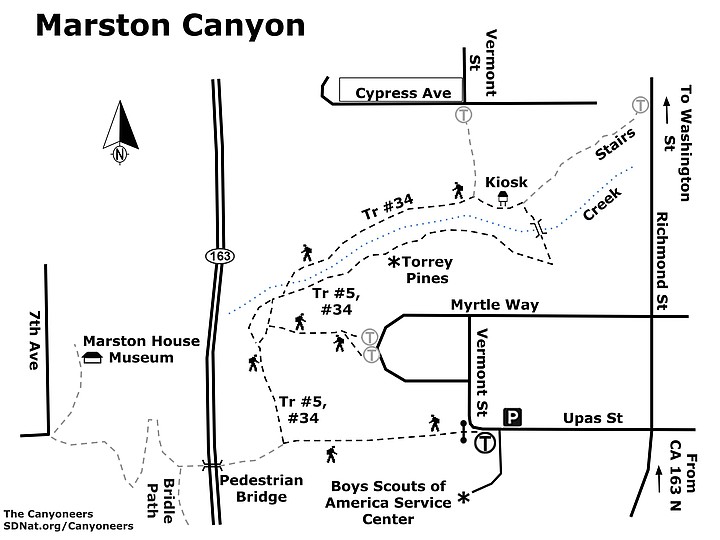
This urban canyon just north of Balboa Park features a wide variety of native and non-native vegetation surrounding a cobblestone creek. The canyon follows a creek bed from Richmond Street to CA-163. Two parallel trails flank the creek with side trails connecting to access points. There are five entrance points into the canyon. This guide follows the paved, gated access road leading from the Boy Scout Service Center to a pedestrian bridge over CA-163. There are also two sets of stairs at Myrtle Way, wooden stairs on Richmond Street, and a gated gravel road on the corner of Cypress Avenue and Vermont Street. There are no access restrictions. However, visiting canyons after dark is not recommended.
Marston Canyon offers something to enjoy every season of the year. Colorful wildflowers in the spring, a shady grove during the hot summer months, and a flowing creek during the rainy season. A remarkable feature of this canyon is the presence of coastal sage scrub native plants together with non-native and ornamental escapees from neighbors’ backyards or intentionally planted. The hike can also be extended by crossing over the CA-163 pedestrian bridge to access the vast network of Balboa Park marked trails or to visit the Marston House and Museum one half mile from the trailhead. George Marston has been called “San Diego’s first citizen.” A businessman and a philanthropist, he was involved in establishing Balboa Park, Presidio Park, and the San Diego public library system.
From the gated trailhead, walk down the paved road west towards the CA-163 pedestrian bridge for 0.15 mile. Before reaching the bridge, next to a stand of prickly pear cactus, turn right to enter the canyon at a dirt access path marked by a post with signs for Balboa Park Trails #5 and #34. Follow this trail to a path at 0.21 mile, marked by a post with signs for trails #5 and #34. Turn right at the post and start a gentle climb with homes on the right—along with native toyon, Mexican elderberry, and non-native garden nasturtiums—to reach a concrete staircase leading to Myrtle Way. A few steps to the left leads to another concrete staircase flanked by non-native fennel and native Cleveland sage to re-enter the canyon under a thick grove of Chinese elms. This detour leads back to the main trail and a junction closer to the creek at 0.39 mile. Turn right to reach two parallel trails on either side of the cobblestone creek. Take the near trail at 0.41 mile, also marked by a post for trails #5 and #34, past black sage and toyon to a stand of rare Torrey pines. Continue past California sagebrush, coyote brush, Mexican elderberry, and a single jojoba tree, more typically seen in the desert. A coast live oak shades the trail across from a tangle of invasive wild radish before reaching a wooden bridge under a shady grove of Chinese elms at approximately 0.60 mile. Cross the creek to reach a T junction. To the right is a stand of eucalyptus trees, native to Australia and a few south Pacific islands, and the trail to the Richmond Street stairs.
Turn left to start the return leg of the loop trail. Reach the Marston Canyon Kiosk at mile 0.67, and continue west. At mile 0.71, a large Peruvian pepper tree marks a side trail to the right that rises to the exit on Cypress Avenue and Vermont Street. Continue straight on trail #34 past a large cypress and riparian vegetation including native sycamores, arroyo willow, and curly dock growing near the creek. Pass another shady Chinese elm to reach the creek crossing. Take the right leg of the Y, and head uphill to a second Y, this time taking the left leg and the trail back to the paved access road at 0.98 mile. Turn left and climb out of the canyon to the trailhead passing non-native olive trees, black mustard, fennel, tree tobacco, and plumbago growing next to native laurel sumac, lemonadeberry, and prickly pear cacti. Or you can turn right and cross the bridge over CA-163 to explore other Balboa Park trails.
Marston Canyon map
MARSTON CANYON
Discover a quiet urban canyon connected to the Balboa Park trails network.
- Driving directions: From CA-163 North, take Richmond Street exit, turn left at Upas Street. Go 0.1 mile to Vermont Street. From CA-163 South, go east on Washington Street for 0.3 mile. Turn right on Richmond Street. Go 0.6 mile. Turn right on Upas Street. Go 0.1 mile to Vermont Street. The trailhead is on the corner of Upas and Vermont Streets next to the Boys Scouts of America Service Center at 1207 Upas Street. Look for the signpost for Balboa Park Trails #4. Limited street parking available. Hiking length: 1.1-mile loop. All distances indicated from the start. Plan one hour at a leisurely pace. Difficulty: Easy to moderate. The trail has good footing in most places and only a few short, moderately steep sections. Total change in elevation is 120 feet from highest to lowest point. The canyon is apt for hikers, runners, cyclists, children, and pets on a leash. No facilities.
Here's something you might be interested in.
Marston Canyon: follow a creek bed from Richmond Street to CA-163
Discover a quiet urban canyon connected to the Balboa Park trails network.
Marston Canyon: follow a creek bed from Richmond Street to CA-163
Discover a quiet urban canyon connected to the Balboa Park trails network.
A wooden bridge is under a shady grove of Chinese elms
This urban canyon just north of Balboa Park features a wide variety of native and non-native vegetation surrounding a cobblestone creek. The canyon follows a creek bed from Richmond Street to CA-163. Two parallel trails flank the creek with side trails connecting to access points. There are five entrance points into the canyon. This guide follows the paved, gated access road leading from the Boy Scout Service Center to a pedestrian bridge over CA-163. There are also two sets of stairs at Myrtle Way, wooden stairs on Richmond Street, and a gated gravel road on the corner of Cypress Avenue and Vermont Street. There are no access restrictions. However, visiting canyons after dark is not recommended.
Marston Canyon offers something to enjoy every season of the year. Colorful wildflowers in the spring, a shady grove during the hot summer months, and a flowing creek during the rainy season. A remarkable feature of this canyon is the presence of coastal sage scrub native plants together with non-native and ornamental escapees from neighbors’ backyards or intentionally planted. The hike can also be extended by crossing over the CA-163 pedestrian bridge to access the vast network of Balboa Park marked trails or to visit the Marston House and Museum one half mile from the trailhead. George Marston has been called “San Diego’s first citizen.” A businessman and a philanthropist, he was involved in establishing Balboa Park, Presidio Park, and the San Diego public library system.
From the gated trailhead, walk down the paved road west towards the CA-163 pedestrian bridge for 0.15 mile. Before reaching the bridge, next to a stand of prickly pear cactus, turn right to enter the canyon at a dirt access path marked by a post with signs for Balboa Park Trails #5 and #34. Follow this trail to a path at 0.21 mile, marked by a post with signs for trails #5 and #34. Turn right at the post and start a gentle climb with homes on the right—along with native toyon, Mexican elderberry, and non-native garden nasturtiums—to reach a concrete staircase leading to Myrtle Way. A few steps to the left leads to another concrete staircase flanked by non-native fennel and native Cleveland sage to re-enter the canyon under a thick grove of Chinese elms. This detour leads back to the main trail and a junction closer to the creek at 0.39 mile. Turn right to reach two parallel trails on either side of the cobblestone creek. Take the near trail at 0.41 mile, also marked by a post for trails #5 and #34, past black sage and toyon to a stand of rare Torrey pines. Continue past California sagebrush, coyote brush, Mexican elderberry, and a single jojoba tree, more typically seen in the desert. A coast live oak shades the trail across from a tangle of invasive wild radish before reaching a wooden bridge under a shady grove of Chinese elms at approximately 0.60 mile. Cross the creek to reach a T junction. To the right is a stand of eucalyptus trees, native to Australia and a few south Pacific islands, and the trail to the Richmond Street stairs.
Turn left to start the return leg of the loop trail. Reach the Marston Canyon Kiosk at mile 0.67, and continue west. At mile 0.71, a large Peruvian pepper tree marks a side trail to the right that rises to the exit on Cypress Avenue and Vermont Street. Continue straight on trail #34 past a large cypress and riparian vegetation including native sycamores, arroyo willow, and curly dock growing near the creek. Pass another shady Chinese elm to reach the creek crossing. Take the right leg of the Y, and head uphill to a second Y, this time taking the left leg and the trail back to the paved access road at 0.98 mile. Turn left and climb out of the canyon to the trailhead passing non-native olive trees, black mustard, fennel, tree tobacco, and plumbago growing next to native laurel sumac, lemonadeberry, and prickly pear cacti. Or you can turn right and cross the bridge over CA-163 to explore other Balboa Park trails.
Marston Canyon map
MARSTON CANYON
Discover a quiet urban canyon connected to the Balboa Park trails network.
- Driving directions: From CA-163 North, take Richmond Street exit, turn left at Upas Street. Go 0.1 mile to Vermont Street. From CA-163 South, go east on Washington Street for 0.3 mile. Turn right on Richmond Street. Go 0.6 mile. Turn right on Upas Street. Go 0.1 mile to Vermont Street. The trailhead is on the corner of Upas and Vermont Streets next to the Boys Scouts of America Service Center at 1207 Upas Street. Look for the signpost for Balboa Park Trails #4. Limited street parking available. Hiking length: 1.1-mile loop. All distances indicated from the start. Plan one hour at a leisurely pace. Difficulty: Easy to moderate. The trail has good footing in most places and only a few short, moderately steep sections. Total change in elevation is 120 feet from highest to lowest point. The canyon is apt for hikers, runners, cyclists, children, and pets on a leash. No facilities.