Here's something you might be interested in.
Ask a Hipster — Advice you didn't know you needed
Big Screen — Movie commentary
Blurt — Music's inside track
Booze News — San Diego spirits
Classical Music — Immortal beauty
Classifieds — Free and easy
Close to Home — What it’s like on the street where you live
Cover Stories — Front-page features
Drinks All Around — Bartenders' drink recipes
Excerpts — Literary and spiritual excerpts
Feast! — Food & drink reviews
Feature Stories — Local news & stories
Fishing Report — What’s getting hooked from ship and shore
From the Archives — Spotlight on the past
Golden Dreams — Talk of the town
The Gonzo Report — Making the musical scene, or at least reporting from it
Letters — Our inbox
Movies@Home — Local movie buffs share favorites
Movie Reviews — Our critics' picks and pans
Musician Interviews — Up close with local artists
Neighborhood News from Stringers — Hyperlocal news
News Ticker — News & politics
Obermeyer — San Diego politics illustrated
Outdoors — Weekly changes in flora and fauna
Overheard in San Diego — Eavesdropping illustrated
Poetry — The old and the new
Reader Travel — Travel section built by travelers
Reading — The hunt for intellectuals
Roam-O-Rama — SoCal's best hiking/biking trails
San Diego Beer — Inside San Diego suds
SD on the QT — Almost factual news
Sheep and Goats — Places of worship
Special Issues — The best of
Street Style — San Diego streets have style
Surf Diego — Real stories from those braving the waves
Theater — On stage in San Diego this week
Tin Fork — Silver spoon alternative
Under the Radar — Matt Potter's undercover work
Unforgettable — Long-ago San Diego
Unreal Estate — San Diego's priciest pads
Your Week — Daily event picks
Balboa Park Trails
Incremental improvements over the past couple of years in Balboa Park’s hidden corners are resulting in the park’s rebirth. Canyon slopes formerly choked with dense undergrowth and used as de-facto drug dens have been cleared out and made user-friendly for local residents and tourists. Forgotten pathways are being reconstructed.
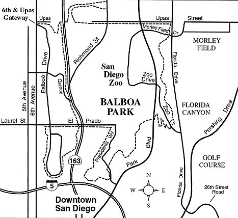
The latest improvements were highlighted in late October when Mayor Jerry Sanders ceremonially inaugurated the Balboa Park Trails system at the northwest corner of the park. That’s exactly where you can now find the Sixth and Upas Gateway, the first of five major trailheads planned for various parts of the park.
Five numbered trails emanate from the Sixth and Upas Gateway, ranging from 1.5 miles to 6.6 miles in length. Each “trail” is actually a route suitable for walking, running, and sometimes skating or biking. The routes utilize everything from smooth sidewalks to rough paths darting up and down the park’s steep canyonsides. All are configured as loops, and their designated direction takes maximum advantage of the scenery and the terrain. A dozen or more numbered trails are envisioned for the four other gateways, which are planned for Morley Field, Golden Hill, Park Administration parking lot, and Marston Point.
The Sixth and Upas Gateway itself posts a detailed map of the park and the five trails associated with that point of origin. The signage is innovative: Trail signs along each route contain a background color (blue for trails originating at Sixth and Upas, other background colors for the future gateways); a trail number inside a color-coded geometric shape (round for an easy trail, square for a medium difficulty trail, diamond for a difficult trail); an elapsed mileage figure; and directional arrows.
To get a feel for the layout of the new Balboa Park Trails, and get some significant exercise at the same time, try following Trail 5, which is rated “difficult.” That trail, indicated by dashes on this column’s sketch map, takes you through park locales both familiar and probably unfamiliar, and includes a number of wickedly steep (though brief) uphill and downhill passages.
You begin by descending toward Highway 163 and crossing over the busy freeway on the antique (by modern freeway standards) Bridle Trail overpass. Next comes a detour into the little-known Marston Hills Addition of the park, which edges into the Hillcrest neighborhood.
You then follow Upas Street east to Florida Drive, where you begin a traverse south along a hillside, using a pathway that has long been a part of the park’s Florida Canyon trail system. After crossing Zoo Drive, you follow a zig-zag ascent up through the park’s succulent gardens, and then cross over Park Avenue on a footbridge, arriving at the circular fountain.
Nearby, alongside the Fleet science museum, you dart down past the butterfly garden and enter Gold Gulch, home of the park’s horse stables. Emerging from the gulch you head south to loop around the back side of the Air and Space Museum and follow Presidents Way to connect with El Prado.
Next, a trip across the Cabrillo Bridge takes you to the green spaces near Sixth and Laurel. After a looping passage south to visit Marston Point, you dive into the canyon to the east and follow the Bridle Trail north alongside Highway 163. You pass under the tall arches of the iconic Cabrillo Bridge and proceed through stately groves of native coast live oaks, redwoods, and various pines. Arriving at the Bridle Trail overpass once again, you retrace your steps on the initial 0.2-mile segment to return to the Sixth and Upas Gateway.
A full-color map of all five of the Sixth and Upas trails, plus other maps of Balboa Park, may be obtained as PDF downloads by visiting balboapark.org/maps/.
Balboa Park Trails
Explore the new and improved trails of Balboa Park.
Distance from downtown San Diego: 2 miles
Hiking length: 6.6 miles (longest trail)
Difficulty: Moderately strenuous
Here's something you might be interested in.
Balboa Park Trails
Balboa Park Trails
Incremental improvements over the past couple of years in Balboa Park’s hidden corners are resulting in the park’s rebirth. Canyon slopes formerly choked with dense undergrowth and used as de-facto drug dens have been cleared out and made user-friendly for local residents and tourists. Forgotten pathways are being reconstructed.
The latest improvements were highlighted in late October when Mayor Jerry Sanders ceremonially inaugurated the Balboa Park Trails system at the northwest corner of the park. That’s exactly where you can now find the Sixth and Upas Gateway, the first of five major trailheads planned for various parts of the park.
Five numbered trails emanate from the Sixth and Upas Gateway, ranging from 1.5 miles to 6.6 miles in length. Each “trail” is actually a route suitable for walking, running, and sometimes skating or biking. The routes utilize everything from smooth sidewalks to rough paths darting up and down the park’s steep canyonsides. All are configured as loops, and their designated direction takes maximum advantage of the scenery and the terrain. A dozen or more numbered trails are envisioned for the four other gateways, which are planned for Morley Field, Golden Hill, Park Administration parking lot, and Marston Point.
The Sixth and Upas Gateway itself posts a detailed map of the park and the five trails associated with that point of origin. The signage is innovative: Trail signs along each route contain a background color (blue for trails originating at Sixth and Upas, other background colors for the future gateways); a trail number inside a color-coded geometric shape (round for an easy trail, square for a medium difficulty trail, diamond for a difficult trail); an elapsed mileage figure; and directional arrows.
To get a feel for the layout of the new Balboa Park Trails, and get some significant exercise at the same time, try following Trail 5, which is rated “difficult.” That trail, indicated by dashes on this column’s sketch map, takes you through park locales both familiar and probably unfamiliar, and includes a number of wickedly steep (though brief) uphill and downhill passages.
You begin by descending toward Highway 163 and crossing over the busy freeway on the antique (by modern freeway standards) Bridle Trail overpass. Next comes a detour into the little-known Marston Hills Addition of the park, which edges into the Hillcrest neighborhood.
You then follow Upas Street east to Florida Drive, where you begin a traverse south along a hillside, using a pathway that has long been a part of the park’s Florida Canyon trail system. After crossing Zoo Drive, you follow a zig-zag ascent up through the park’s succulent gardens, and then cross over Park Avenue on a footbridge, arriving at the circular fountain.
Nearby, alongside the Fleet science museum, you dart down past the butterfly garden and enter Gold Gulch, home of the park’s horse stables. Emerging from the gulch you head south to loop around the back side of the Air and Space Museum and follow Presidents Way to connect with El Prado.
Next, a trip across the Cabrillo Bridge takes you to the green spaces near Sixth and Laurel. After a looping passage south to visit Marston Point, you dive into the canyon to the east and follow the Bridle Trail north alongside Highway 163. You pass under the tall arches of the iconic Cabrillo Bridge and proceed through stately groves of native coast live oaks, redwoods, and various pines. Arriving at the Bridle Trail overpass once again, you retrace your steps on the initial 0.2-mile segment to return to the Sixth and Upas Gateway.
A full-color map of all five of the Sixth and Upas trails, plus other maps of Balboa Park, may be obtained as PDF downloads by visiting balboapark.org/maps/.
Balboa Park Trails
Explore the new and improved trails of Balboa Park.
Distance from downtown San Diego: 2 miles
Hiking length: 6.6 miles (longest trail)
Difficulty: Moderately strenuous