Here's something you might be interested in.
Ask a Hipster — Advice you didn't know you needed
Big Screen — Movie commentary
Blurt — Music's inside track
Booze News — San Diego spirits
Classical Music — Immortal beauty
Classifieds — Free and easy
Close to Home — What it’s like on the street where you live
Cover Stories — Front-page features
Drinks All Around — Bartenders' drink recipes
Excerpts — Literary and spiritual excerpts
Feast! — Food & drink reviews
Feature Stories — Local news & stories
Fishing Report — What’s getting hooked from ship and shore
From the Archives — Spotlight on the past
Golden Dreams — Talk of the town
The Gonzo Report — Making the musical scene, or at least reporting from it
Letters — Our inbox
Movies@Home — Local movie buffs share favorites
Movie Reviews — Our critics' picks and pans
Musician Interviews — Up close with local artists
Neighborhood News from Stringers — Hyperlocal news
News Ticker — News & politics
Obermeyer — San Diego politics illustrated
Outdoors — Weekly changes in flora and fauna
Overheard in San Diego — Eavesdropping illustrated
Poetry — The old and the new
Reader Travel — Travel section built by travelers
Reading — The hunt for intellectuals
Roam-O-Rama — SoCal's best hiking/biking trails
San Diego Beer — Inside San Diego suds
SD on the QT — Almost factual news
Sheep and Goats — Places of worship
Special Issues — The best of
Street Style — San Diego streets have style
Surf Diego — Real stories from those braving the waves
Theater — On stage in San Diego this week
Tin Fork — Silver spoon alternative
Under the Radar — Matt Potter's undercover work
Unforgettable — Long-ago San Diego
Unreal Estate — San Diego's priciest pads
Your Week — Daily event picks
One of the easiest hikes in the San Diego area…if you're a mountain goat
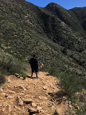
The climb to Three Sisters is well worth it
Descent into the canyon
While some in North America still shovel snow, San Diegans have the perfect venue for a hot March day — Three Sisters Falls, for a plunge in the frigid mountain water. The trail down to Boulder Creek is rated as one of the hardest short hikes in San Diego. The trail is steep, dropping approximately 1000 feet in elevation. Along with the elevation, the heat can be extreme if visiting during the summer. Temperatures can soar to 100 degrees, making water a primary planning consideration.
From the trailhead, the trail is almost two miles to the top of the falls. At the start of the trail, visitors are greeted with a wide, easy path. This section goes through open grassy areas with a variety of chaparral species including chamise, manzanita, and white sage. Across most of this open area are large sections of Engelmann oak (Quercus engelmannii). These gorgeous blue-green-leafed oaks are one of the many evergreen trees found throughout Southern California. They are drought deciduous, which means that they can drop their leaves to conserve water when stressed.
Boulder scrambling and slippery rock
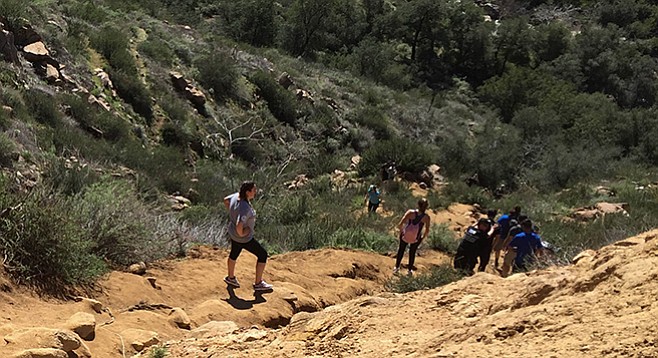
The slope quickly narrows as it descends to Sheep Camp Creek. At the creek crossing, the trail flattens out and visitors are taken through a shaded riparian grove of oak and willow. Once through the grove, hikers encounter an eroded narrow trail that is very steep. If necessary, visitors can rest before making their final descent to the canyon floor, as there are many spots allowing folks to sit off trail and out of the way of other travelers.
The steepest and last section of trail drops approximately 400 feet before reaching the canyon floor. This final section has anchor ropes that can be used as handholds to safely navigate the slope. The descent increases in steepness as you continue down into the canyon, with the final section requiring bouldering to reach the canyon floor. Upon reaching the bottom, the real hike begins and visitors must climb the remaining quarter mile up stream to the falls.
The path up to the falls is well marked, but visitors will have to climb over large sections of boulders to reach the top as they navigate up Boulder Creek Canyon. These rock surfaces can be very slippery. An additional watch-out is the poison oak, which is all along the trail, and during the warmer seasons, be on the lookout for rattlesnakes.
Waiting to descend
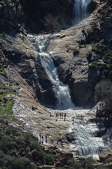
The climb is well worth it, as visitors are greeted by the trail’s namesake — the Three Sisters. The lower falls can be a trickle during the heat of summer, but in a wet winter, it becomes a rushing torrent that drops 20 feet into the pool below. The path to the top section requires more rock scrambling and the use of ropes anchored into the granite walls. Once at the top, the view of Boulder Canyon and the Three Sisters is breath-taking.
Of course, what comes down must go up! Visitors will have to hike back up the nearly two miles of trail and 1000 feet of hillside to get back to the trailhead and their vehicles. More information can be found with a search of Three Sisters Falls that shows the 45-degree sections and terrain needed to be crossed. Another option is to pass the trail turning left to Three Sisters Falls and continue to Eagle Peak.
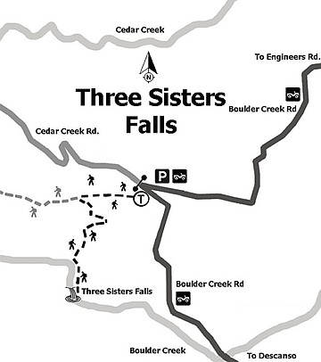
Map to Three Sisters Falls
Three Sisters Falls
Distance from downtown San Diego: approximately 65 miles. Allow 1.5 hours driving time (Cleveland National Forest). From I-8, exit north on SR-79 and then head west on Riverside Dr. Turn west on Viejas Grade then make an immediate right past the store onto Oak Grove Dr. Turn right on Boulder Creek Rd. and drive 13 miles (7 miles is on a well-kept dirt road) to a hairpin turn that intersects Cedar Creek Rd. and the trailhead. The trailhead is for both Three Sisters Falls and Eagle Peak with Cedar Creek Fire Rd. slightly to the north. Park near the hairpin turn with an USFS Adventure Pass in view. The Boulder Creek Rd. trailhead also can be accessed via Engineers Rd. from Lake Cuyamaca. It is a shorter route but has many hairpin turns.
Hiking length: approximately 4 miles out-and-back.
Difficulty: Strenuous with steep slopes with 1000 feet elevation loss/gain from the highest point to the canyon floor. The trail is not maintained and has severe erosion in some areas. Proceed at your own risk over loose sand and slippery rocks with boulder scrambling. A couple of spots have ropes due to the steepness. Dogs are allowed but are discouraged as the trail descending into the canyon is not appropriate for pets. Open fires are not allowed. At least two liters of water, gloves, and good hiking shoes/boots are recommended for this trail. No facilities.
Here's something you might be interested in.
One of the easiest hikes in the San Diego area…if you're a mountain goat
The climb to Three Sisters is well worth it
One of the easiest hikes in the San Diego area…if you're a mountain goat
The climb to Three Sisters is well worth it
Descent into the canyon
While some in North America still shovel snow, San Diegans have the perfect venue for a hot March day — Three Sisters Falls, for a plunge in the frigid mountain water. The trail down to Boulder Creek is rated as one of the hardest short hikes in San Diego. The trail is steep, dropping approximately 1000 feet in elevation. Along with the elevation, the heat can be extreme if visiting during the summer. Temperatures can soar to 100 degrees, making water a primary planning consideration.
From the trailhead, the trail is almost two miles to the top of the falls. At the start of the trail, visitors are greeted with a wide, easy path. This section goes through open grassy areas with a variety of chaparral species including chamise, manzanita, and white sage. Across most of this open area are large sections of Engelmann oak (Quercus engelmannii). These gorgeous blue-green-leafed oaks are one of the many evergreen trees found throughout Southern California. They are drought deciduous, which means that they can drop their leaves to conserve water when stressed.
Boulder scrambling and slippery rock
The slope quickly narrows as it descends to Sheep Camp Creek. At the creek crossing, the trail flattens out and visitors are taken through a shaded riparian grove of oak and willow. Once through the grove, hikers encounter an eroded narrow trail that is very steep. If necessary, visitors can rest before making their final descent to the canyon floor, as there are many spots allowing folks to sit off trail and out of the way of other travelers.
The steepest and last section of trail drops approximately 400 feet before reaching the canyon floor. This final section has anchor ropes that can be used as handholds to safely navigate the slope. The descent increases in steepness as you continue down into the canyon, with the final section requiring bouldering to reach the canyon floor. Upon reaching the bottom, the real hike begins and visitors must climb the remaining quarter mile up stream to the falls.
The path up to the falls is well marked, but visitors will have to climb over large sections of boulders to reach the top as they navigate up Boulder Creek Canyon. These rock surfaces can be very slippery. An additional watch-out is the poison oak, which is all along the trail, and during the warmer seasons, be on the lookout for rattlesnakes.
Waiting to descend
The climb is well worth it, as visitors are greeted by the trail’s namesake — the Three Sisters. The lower falls can be a trickle during the heat of summer, but in a wet winter, it becomes a rushing torrent that drops 20 feet into the pool below. The path to the top section requires more rock scrambling and the use of ropes anchored into the granite walls. Once at the top, the view of Boulder Canyon and the Three Sisters is breath-taking.
Of course, what comes down must go up! Visitors will have to hike back up the nearly two miles of trail and 1000 feet of hillside to get back to the trailhead and their vehicles. More information can be found with a search of Three Sisters Falls that shows the 45-degree sections and terrain needed to be crossed. Another option is to pass the trail turning left to Three Sisters Falls and continue to Eagle Peak.
Map to Three Sisters Falls
Three Sisters Falls
Distance from downtown San Diego: approximately 65 miles. Allow 1.5 hours driving time (Cleveland National Forest). From I-8, exit north on SR-79 and then head west on Riverside Dr. Turn west on Viejas Grade then make an immediate right past the store onto Oak Grove Dr. Turn right on Boulder Creek Rd. and drive 13 miles (7 miles is on a well-kept dirt road) to a hairpin turn that intersects Cedar Creek Rd. and the trailhead. The trailhead is for both Three Sisters Falls and Eagle Peak with Cedar Creek Fire Rd. slightly to the north. Park near the hairpin turn with an USFS Adventure Pass in view. The Boulder Creek Rd. trailhead also can be accessed via Engineers Rd. from Lake Cuyamaca. It is a shorter route but has many hairpin turns.
Hiking length: approximately 4 miles out-and-back.
Difficulty: Strenuous with steep slopes with 1000 feet elevation loss/gain from the highest point to the canyon floor. The trail is not maintained and has severe erosion in some areas. Proceed at your own risk over loose sand and slippery rocks with boulder scrambling. A couple of spots have ropes due to the steepness. Dogs are allowed but are discouraged as the trail descending into the canyon is not appropriate for pets. Open fires are not allowed. At least two liters of water, gloves, and good hiking shoes/boots are recommended for this trail. No facilities.
Comments