Here's something you might be interested in.
Ask a Hipster — Advice you didn't know you needed
Big Screen — Movie commentary
Blurt — Music's inside track
Booze News — San Diego spirits
Classical Music — Immortal beauty
Classifieds — Free and easy
Close to Home — What it’s like on the street where you live
Cover Stories — Front-page features
Drinks All Around — Bartenders' drink recipes
Excerpts — Literary and spiritual excerpts
Feast! — Food & drink reviews
Feature Stories — Local news & stories
Fishing Report — What’s getting hooked from ship and shore
From the Archives — Spotlight on the past
Golden Dreams — Talk of the town
The Gonzo Report — Making the musical scene, or at least reporting from it
Letters — Our inbox
Movies@Home — Local movie buffs share favorites
Movie Reviews — Our critics' picks and pans
Musician Interviews — Up close with local artists
Neighborhood News from Stringers — Hyperlocal news
News Ticker — News & politics
Obermeyer — San Diego politics illustrated
Outdoors — Weekly changes in flora and fauna
Overheard in San Diego — Eavesdropping illustrated
Poetry — The old and the new
Reader Travel — Travel section built by travelers
Reading — The hunt for intellectuals
Roam-O-Rama — SoCal's best hiking/biking trails
San Diego Beer — Inside San Diego suds
SD on the QT — Almost factual news
Sheep and Goats — Places of worship
Special Issues — The best of
Street Style — San Diego streets have style
Surf Diego — Real stories from those braving the waves
Theater — On stage in San Diego this week
Tin Fork — Silver spoon alternative
Under the Radar — Matt Potter's undercover work
Unforgettable — Long-ago San Diego
Unreal Estate — San Diego's priciest pads
Your Week — Daily event picks
Splash in the Devil's Punchbowl
Nobody’s allowed to jump in.
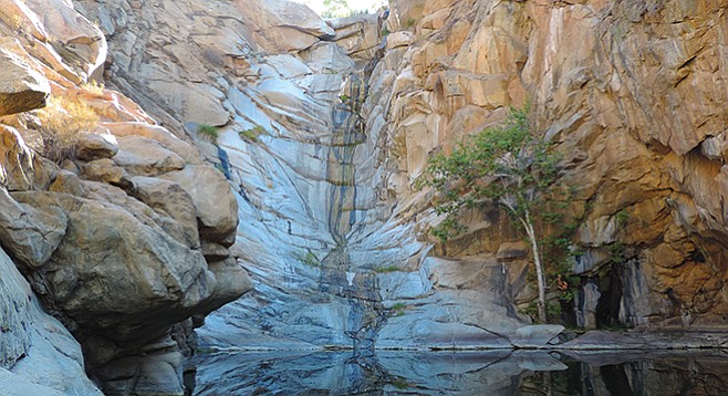
Even in a dry year, the pool is cool and refreshing.
As anyone acquainted with San Diego County knows, free-flowing water is a scarce commodity, and a substantial waterfall is an even rarer occurrence. At 90 feet, Cedar Creek Falls in the Cleveland National Forest is just shy of the highest waterfall in the county and arguably the easiest to hike to.
There are two approaches to Cedar Creek Falls. For those willing to make an 8-mile drive over potentially poor dirt roads, access can be gained southwest of Julian via Eagle Peak Road. There is only limited parking at the trailhead. The recommended route is via the Thornbush Trailhead from the Ramona side, which has been greatly improved and no longer requires parking on neighborhood streets. Here there is plenty of parking, water, toilet facilities, and seasonal live-in hosts to get your hike off to a good start on the San Diego River Gorge Trail to the falls.
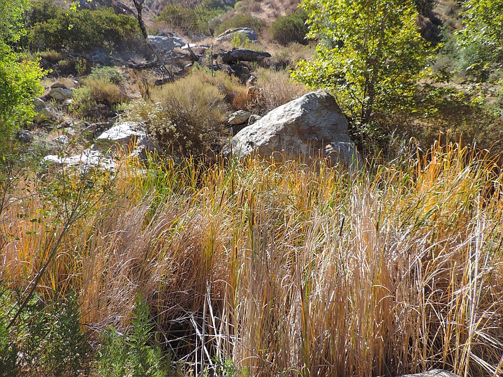
Cedar Creek cattails
Over the years, Cedar Creek Falls has developed a reputation as one of the most spectacular waterfalls in San Diego County and also as one of the area’s more strenuous hikes. While the beauty of the falls is without question, the difficulty of this six-mile out-and-back hike is largely determined by the planning and preparation of the hiker. A multitude of signs at the start of the trail caution hikers to carry at least one gallon of water per person, warn that the temperature at the canyon floor may be up to 15 degrees higher than at the trailhead, and strongly discourages bringing dogs due to the heat. While the trek down seems rather easy, the shadeless climb back out in the heat of the day has caused many an emergency rescue of ill-prepared hikers and their dogs. Get an early start on this hike to beat rising temperatures and the crowds found in the later morning and afternoon.
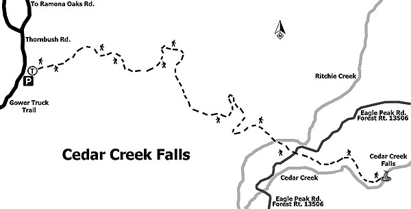
Trail to Cedar Creek Falls
The trail itself is well-maintained and clearly marked. On the way to the falls, the descent is steady at a little over 1000 ft. in the 2.5 miles to Cedar Creek. Watch for the aptly named catclaw acacia beside the trail. Look but don’t touch, as the claw-like thorns have bloodied many an unwary finger. Reaching the bottom of the creek, cross the Eagle Peak Trail and enter the required permit area where a lone sign points toward the Cedar Creek Waterfall.
Water along the stream bed allows for a variety of riparian trees, including coast live oaks, western cottonwoods, sycamores, and willows. Their welcome shade provides relief on a warming day. Beyond the trees, there is a little boulder-scrambling for 0.5 mile between the steep walls of the narrowing canyon. At the end of the canyon, forward progress is halted by the granitic rock face of Cedar Creek Falls and the Devil’s Punchbowl. This pool is 50 feet across and as deep as 20 feet during the rainy season. While climbing and diving from the surrounding rocks is no longer permitted, the cool water in the pool makes for a refreshing plunge. Be careful walking around the pool, as the rock can be very slippery with wet feet. While enjoying the scenery, keep an eye out for side-blotched lizards sunning on the rocks and black phoebe displaying their elegant black-and-white tuxedo as they fly out to snap up insects over the pool. Have a good drink of your water and something to eat before starting your uphill return to the trailhead.
It is hard to believe that this tranquil area was where the worst fire in California history began. The horrific Cedar Fire of 2003 burned 280,278 acres, destroyed 2820 homes and buildings, killed 15 people, injured 113 people, and cost about $30 million just to fight the fire. It burned for almost a month before it was completely contained.
Distance from downtown San Diego: 42 miles. Allow 1 hour driving time. Take I-8 E to SR-67 N for 6 miles, then turn right onto Mapleview St. and then left onto Ashwood St. Continue onto Wildcat Canyon Rd. for 12 miles and turn right onto San Vicente Rd., then left onto Ramona Oaks Rd., then right onto Thornbush Rd. Continue to the trailhead and park in the lot. A National Forest Adventure Pass is not required to park here, but a Cedar Creek Falls Visitor Use Permit is required for the area that surrounds the falls. Permits available online at recreation.gov or by calling 877-444-6777. A $6 permit is good for up to five people.
Hiking length: 6 miles out and back. Allow 4 hours.
Difficulty: Extremely difficult, due mainly to heat, with about 1000 feet elevation loss/gain. Hikers, bicycles, equestrians, and dogs (on leashes) are allowed. Facilities at Thornbush Trailhead. No alcohol allowed.
Here's something you might be interested in.
Splash in the Devil's Punchbowl
Nobody’s allowed to jump in.
Splash in the Devil's Punchbowl
Nobody’s allowed to jump in.
Even in a dry year, the pool is cool and refreshing.
As anyone acquainted with San Diego County knows, free-flowing water is a scarce commodity, and a substantial waterfall is an even rarer occurrence. At 90 feet, Cedar Creek Falls in the Cleveland National Forest is just shy of the highest waterfall in the county and arguably the easiest to hike to.
There are two approaches to Cedar Creek Falls. For those willing to make an 8-mile drive over potentially poor dirt roads, access can be gained southwest of Julian via Eagle Peak Road. There is only limited parking at the trailhead. The recommended route is via the Thornbush Trailhead from the Ramona side, which has been greatly improved and no longer requires parking on neighborhood streets. Here there is plenty of parking, water, toilet facilities, and seasonal live-in hosts to get your hike off to a good start on the San Diego River Gorge Trail to the falls.
Cedar Creek cattails
Over the years, Cedar Creek Falls has developed a reputation as one of the most spectacular waterfalls in San Diego County and also as one of the area’s more strenuous hikes. While the beauty of the falls is without question, the difficulty of this six-mile out-and-back hike is largely determined by the planning and preparation of the hiker. A multitude of signs at the start of the trail caution hikers to carry at least one gallon of water per person, warn that the temperature at the canyon floor may be up to 15 degrees higher than at the trailhead, and strongly discourages bringing dogs due to the heat. While the trek down seems rather easy, the shadeless climb back out in the heat of the day has caused many an emergency rescue of ill-prepared hikers and their dogs. Get an early start on this hike to beat rising temperatures and the crowds found in the later morning and afternoon.
Trail to Cedar Creek Falls
The trail itself is well-maintained and clearly marked. On the way to the falls, the descent is steady at a little over 1000 ft. in the 2.5 miles to Cedar Creek. Watch for the aptly named catclaw acacia beside the trail. Look but don’t touch, as the claw-like thorns have bloodied many an unwary finger. Reaching the bottom of the creek, cross the Eagle Peak Trail and enter the required permit area where a lone sign points toward the Cedar Creek Waterfall.
Water along the stream bed allows for a variety of riparian trees, including coast live oaks, western cottonwoods, sycamores, and willows. Their welcome shade provides relief on a warming day. Beyond the trees, there is a little boulder-scrambling for 0.5 mile between the steep walls of the narrowing canyon. At the end of the canyon, forward progress is halted by the granitic rock face of Cedar Creek Falls and the Devil’s Punchbowl. This pool is 50 feet across and as deep as 20 feet during the rainy season. While climbing and diving from the surrounding rocks is no longer permitted, the cool water in the pool makes for a refreshing plunge. Be careful walking around the pool, as the rock can be very slippery with wet feet. While enjoying the scenery, keep an eye out for side-blotched lizards sunning on the rocks and black phoebe displaying their elegant black-and-white tuxedo as they fly out to snap up insects over the pool. Have a good drink of your water and something to eat before starting your uphill return to the trailhead.
It is hard to believe that this tranquil area was where the worst fire in California history began. The horrific Cedar Fire of 2003 burned 280,278 acres, destroyed 2820 homes and buildings, killed 15 people, injured 113 people, and cost about $30 million just to fight the fire. It burned for almost a month before it was completely contained.
Distance from downtown San Diego: 42 miles. Allow 1 hour driving time. Take I-8 E to SR-67 N for 6 miles, then turn right onto Mapleview St. and then left onto Ashwood St. Continue onto Wildcat Canyon Rd. for 12 miles and turn right onto San Vicente Rd., then left onto Ramona Oaks Rd., then right onto Thornbush Rd. Continue to the trailhead and park in the lot. A National Forest Adventure Pass is not required to park here, but a Cedar Creek Falls Visitor Use Permit is required for the area that surrounds the falls. Permits available online at recreation.gov or by calling 877-444-6777. A $6 permit is good for up to five people.
Hiking length: 6 miles out and back. Allow 4 hours.
Difficulty: Extremely difficult, due mainly to heat, with about 1000 feet elevation loss/gain. Hikers, bicycles, equestrians, and dogs (on leashes) are allowed. Facilities at Thornbush Trailhead. No alcohol allowed.