Here's something you might be interested in.
Ask a Hipster — Advice you didn't know you needed
Big Screen — Movie commentary
Blurt — Music's inside track
Booze News — San Diego spirits
Classical Music — Immortal beauty
Classifieds — Free and easy
Close to Home — What it’s like on the street where you live
Cover Stories — Front-page features
Drinks All Around — Bartenders' drink recipes
Excerpts — Literary and spiritual excerpts
Feast! — Food & drink reviews
Feature Stories — Local news & stories
Fishing Report — What’s getting hooked from ship and shore
From the Archives — Spotlight on the past
Golden Dreams — Talk of the town
The Gonzo Report — Making the musical scene, or at least reporting from it
Letters — Our inbox
Movies@Home — Local movie buffs share favorites
Movie Reviews — Our critics' picks and pans
Musician Interviews — Up close with local artists
Neighborhood News from Stringers — Hyperlocal news
News Ticker — News & politics
Obermeyer — San Diego politics illustrated
Outdoors — Weekly changes in flora and fauna
Overheard in San Diego — Eavesdropping illustrated
Poetry — The old and the new
Reader Travel — Travel section built by travelers
Reading — The hunt for intellectuals
Roam-O-Rama — SoCal's best hiking/biking trails
San Diego Beer — Inside San Diego suds
SD on the QT — Almost factual news
Sheep and Goats — Places of worship
Special Issues — The best of
Street Style — San Diego streets have style
Surf Diego — Real stories from those braving the waves
Theater — On stage in San Diego this week
Tin Fork — Silver spoon alternative
Under the Radar — Matt Potter's undercover work
Unforgettable — Long-ago San Diego
Unreal Estate — San Diego's priciest pads
Your Week — Daily event picks
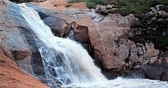
Three Sisters Falls
The triple set of waterfalls dubbed the “Three Sisters” is an amazing San Diego County feature not many have seen. In full flood, these cascades put on a show reminiscent of Yosemite’s show stoppers — except at a reduced scale. Since some of the upstream drainage of Boulder Creek comes from Cuyamaca Reservoir, regulated releases of water there can greatly affect the volume of water flowing over the falls.
Although the round-trip hike measures only four miles from the nearest road, visiting the falls is a task for expert hikers, not beginners. Take along drinking water, and be prepared for some strenuous climbing, both up and down, on marginal pathways and on no trail at all near the falls themselves.
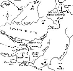
To get to the trailhead from San Diego, exit Interstate 8 at Highway 79 (Descanso exit) and drive north. After 1.3 miles turn left on Riverside Drive. Continue 0.6 mile to the main crossroads (post office, etc.) of the hamlet of Descanso. From there take Oak Grove Drive 1.6 miles to the intersection of Boulder Creek Road on the right. Follow Boulder Creek Road north for 13.0 miles (first half paved, then dirt) to a hairpin turn where unpaved Cedar Creek Road joins from the west. Park there, taking care not to block traffic, and post a National Forest Adventure Pass on your car (the parking area and falls lie in Cleveland National Forest territory).
On foot now, follow the remains of an old ranch road (not Cedar Creek Road) due west for 0.7 mile to a saddle, where an old mining road on the left slants southeast and descends into Sheep Camp Creek. You can both see and hear the falls from this saddle.
Descend southwest on the mining road for 0.4 mile, cross Sheep Camp Creek, and switch back onto a narrow path cut into the south slope. After about 0.3 mile, the trail veers sharply left and passes over a saddle in the divide between Sheep Camp Creek and Boulder Creek.
Next, you negotiate an abrupt drop of 500 vertical feet through chaparral on a primitive — and in places excessively steep and slippery — trail cut by hikers’ footsteps. At the bottom you can either forge a route through the brush and angular rocks along the left side of the creek or (if the water level is not too high) rock hop and wade toward the falls. Great masses of poison oak, intermixed with wild grape vines, lie along the banks. Be very cautious of slippery rocks.
When you reach the base of the waterfalls, all the previous thrashing about will have been worth it. The “middle sister” is impressive, with water sliding 50 feet down a smooth channel worn in the bedrock into a kidney shaped pool about 80 feet long and at least 10 feet deep. Watch your footing — it’s deceptively easy to slip on the smooth rock and perhaps be seriously injured. It’s difficult and dangerous to climb up to the uppermost waterfall, though some agile climbers have done it.
This article contains information about a publicly owned recreation or wilderness area. Trails and pathways are not necessarily marked. Conditions can change rapidly. Hikers should be properly equipped and have safety and navigational skills. The Reader and Jerry Schad assume no responsibility for any adverse experience.
Three Sisters Falls
Boulder Creek, west of Cuyamaca Peak, cascades down a spectacular triad of waterfalls.
Distance from downtown San Diego: 55 miles
Hiking length: 4 miles round trip
Difficulty: Strenuous
Here's something you might be interested in.
Three Sisters Falls
Three Sisters Falls
The triple set of waterfalls dubbed the “Three Sisters” is an amazing San Diego County feature not many have seen. In full flood, these cascades put on a show reminiscent of Yosemite’s show stoppers — except at a reduced scale. Since some of the upstream drainage of Boulder Creek comes from Cuyamaca Reservoir, regulated releases of water there can greatly affect the volume of water flowing over the falls.
Although the round-trip hike measures only four miles from the nearest road, visiting the falls is a task for expert hikers, not beginners. Take along drinking water, and be prepared for some strenuous climbing, both up and down, on marginal pathways and on no trail at all near the falls themselves.
To get to the trailhead from San Diego, exit Interstate 8 at Highway 79 (Descanso exit) and drive north. After 1.3 miles turn left on Riverside Drive. Continue 0.6 mile to the main crossroads (post office, etc.) of the hamlet of Descanso. From there take Oak Grove Drive 1.6 miles to the intersection of Boulder Creek Road on the right. Follow Boulder Creek Road north for 13.0 miles (first half paved, then dirt) to a hairpin turn where unpaved Cedar Creek Road joins from the west. Park there, taking care not to block traffic, and post a National Forest Adventure Pass on your car (the parking area and falls lie in Cleveland National Forest territory).
On foot now, follow the remains of an old ranch road (not Cedar Creek Road) due west for 0.7 mile to a saddle, where an old mining road on the left slants southeast and descends into Sheep Camp Creek. You can both see and hear the falls from this saddle.
Descend southwest on the mining road for 0.4 mile, cross Sheep Camp Creek, and switch back onto a narrow path cut into the south slope. After about 0.3 mile, the trail veers sharply left and passes over a saddle in the divide between Sheep Camp Creek and Boulder Creek.
Next, you negotiate an abrupt drop of 500 vertical feet through chaparral on a primitive — and in places excessively steep and slippery — trail cut by hikers’ footsteps. At the bottom you can either forge a route through the brush and angular rocks along the left side of the creek or (if the water level is not too high) rock hop and wade toward the falls. Great masses of poison oak, intermixed with wild grape vines, lie along the banks. Be very cautious of slippery rocks.
When you reach the base of the waterfalls, all the previous thrashing about will have been worth it. The “middle sister” is impressive, with water sliding 50 feet down a smooth channel worn in the bedrock into a kidney shaped pool about 80 feet long and at least 10 feet deep. Watch your footing — it’s deceptively easy to slip on the smooth rock and perhaps be seriously injured. It’s difficult and dangerous to climb up to the uppermost waterfall, though some agile climbers have done it.
This article contains information about a publicly owned recreation or wilderness area. Trails and pathways are not necessarily marked. Conditions can change rapidly. Hikers should be properly equipped and have safety and navigational skills. The Reader and Jerry Schad assume no responsibility for any adverse experience.
Three Sisters Falls
Boulder Creek, west of Cuyamaca Peak, cascades down a spectacular triad of waterfalls.
Distance from downtown San Diego: 55 miles
Hiking length: 4 miles round trip
Difficulty: Strenuous