Here's something you might be interested in.
Ask a Hipster — Advice you didn't know you needed
Big Screen — Movie commentary
Blurt — Music's inside track
Booze News — San Diego spirits
Classical Music — Immortal beauty
Classifieds — Free and easy
Cover Stories — Front-page features
Drinks All Around — Bartenders' drink recipes
Excerpts — Literary and spiritual excerpts
Feast! — Food & drink reviews
Feature Stories — Local news & stories
Fishing Report — What’s getting hooked from ship and shore
From the Archives — Spotlight on the past
Golden Dreams — Talk of the town
The Gonzo Report — Making the musical scene, or at least reporting from it
Letters — Our inbox
Movies@Home — Local movie buffs share favorites
Movie Reviews — Our critics' picks and pans
Musician Interviews — Up close with local artists
Neighborhood News from Stringers — Hyperlocal news
News Ticker — News & politics
Obermeyer — San Diego politics illustrated
Outdoors — Weekly changes in flora and fauna
Overheard in San Diego — Eavesdropping illustrated
Poetry — The old and the new
Reader Travel — Travel section built by travelers
Reading — The hunt for intellectuals
Roam-O-Rama — SoCal's best hiking/biking trails
San Diego Beer — Inside San Diego suds
SD on the QT — Almost factual news
Sheep and Goats — Places of worship
Special Issues — The best of
Street Style — San Diego streets have style
Surf Diego — Real stories from those braving the waves
Theater — On stage in San Diego this week
Tin Fork — Silver spoon alternative
Under the Radar — Matt Potter's undercover work
Unforgettable — Long-ago San Diego
Unreal Estate — San Diego's priciest pads
Your Week — Daily event picks
Water? In the desert? Yup.
Rich riparian areas and shaded grottos await adventurous hikers in Sheep Canyon
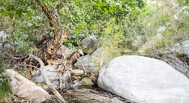
Cottonwoods and sycamores thrive along the banks of the creek.
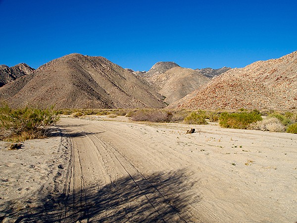
The Sheep Canyon entrance is through Collins Valley.
Sheep Canyon has one of the larger streams flowing east out of the San Ysidro Mountains. Its bubbling waters cascade over boulders and down waterfalls into clear pools, and its banks are lined with shady riparian vegetation, often including tall red willows, California sycamores, and Fremont cottonwood trees. It provides a quiet, peaceful sanctuary where the desert scenery may be enjoyed in a cooler environment. In a wet year, the creek can flow throughout the year. Usually, water is flowing in the canyon from November through April. The rugged hillsides and dependable water make this a safe haven for desert bighorn sheep.
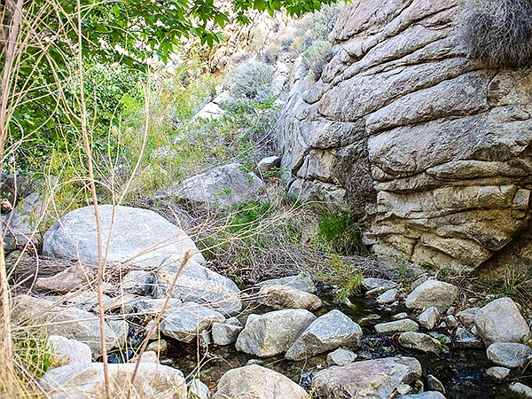
There is no maintained trail into Sheep Canyon beyond the primitive camp area. However, once you leave your parked vehicle, trails seem to be everywhere. You can get through the dense riparian vegetation and up the canyon by carefully choosing among these often interconnecting paths. Stay on the trails near the stream (or the sandy stream bed if the creek is dry) where possible. The stream will have to be crossed frequently to avoid boulders or impenetrable thickets. Occasionally it will be necessary to get around small waterfalls by climbing up the slope on one side of the falls or the other, whichever looks most promising.
Sheep Canyon creek with willows and sycamores.
There are several tributaries that come into the main canyon. The first is the South Fork at 0.4 mile from the primitive campground, which is on the left and heads southwest. Stay in the main canyon, on the right. An unnamed tributary comes into the main canyon 1.2 miles from the campground, on the right. Going up this steep canyon and over the saddle would lead to the South Fork of Salvador Canyon, an interesting adventure that should be saved for another day. Instead, bear to the left as the main canyon continues in a westerly direction. In another half-mile, the canyon opens into a broad bowl into which a third tributary flows from the left. This may be a good place to turn around and go back the way you came, as dense chaparral and steep terrain are found in the upper reaches of Sheep Canyon.
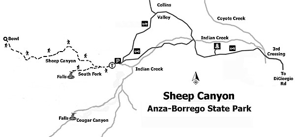
Map to Sheep Canyon
An optional side-trip is possible. Either en route to Sheep Canyon after passing “boulder alley” or upon the return before encountering the boulder field before Third Crossing, take a short detour to the Santa Catarina Monument. It commemorates the Anza expedition that camped at the Santa Catarina Spring in 1774. It also has a great view of the verdant Lower Willows down below and Coyote Canyon to the north. The road to the Monument forks off to the right at 6.6 miles into your trip or 2.9 miles from Sheep Canyon. It is about a half-mile hike to the monument.
Distance from downtown San Diego: About 110 miles. Allow about 3 hours driving time. Drive to Christmas Circle in Borrego Springs and go 0.5-mile east on Palm Canyon Dr. (SR-22). Turn left/north onto DiGiorgio Rd. and drive approximately 5 miles until the pavement ends and the Coyote Canyon dirt road begins. Reset the vehicle odometer to 0. It is 9.5 miles to the entrance of Sheep Canyon. The first creek crossing is at mile 3.7. Most passenger cars can go this far; 4WD is recommended beyond this point because of sand traps, stream crossings, and rough road. The second crossing is at 4.6 miles and the third is at 5.5 miles. The most difficult part of the drive is “boulder alley” just beyond the third crossing. Once past this area, it is an easy drive to the Sheep Canyon Primitive Camp. Keep to the left at road junctions in Collins Valley, except for the final leg into Sheep Canyon, which is signed and is on the right. Vehicle access to this area is prohibited from June 1 through September 30 to protect water resources for bighorn sheep during the summer months.
Hiking length: 3.5 miles out and back and longer if beginning the hike from one of the stream crossings.
Difficulty: moderate to moderately strenuous because of some bushwhacking and boulder-hopping. Elevation gain/loss of 1200 feet. Vault toilets, ramadas, but no water in the primitive camp. Stream water must be treated before use. Recommend the use of a GPS unit or map and compass for route-finding. No dogs allowed on hikes, but leashed dogs are allowed at campsites.
Here's something you might be interested in.
Water? In the desert? Yup.
Rich riparian areas and shaded grottos await adventurous hikers in Sheep Canyon
Water? In the desert? Yup.
Rich riparian areas and shaded grottos await adventurous hikers in Sheep Canyon
Cottonwoods and sycamores thrive along the banks of the creek.
The Sheep Canyon entrance is through Collins Valley.
Sheep Canyon has one of the larger streams flowing east out of the San Ysidro Mountains. Its bubbling waters cascade over boulders and down waterfalls into clear pools, and its banks are lined with shady riparian vegetation, often including tall red willows, California sycamores, and Fremont cottonwood trees. It provides a quiet, peaceful sanctuary where the desert scenery may be enjoyed in a cooler environment. In a wet year, the creek can flow throughout the year. Usually, water is flowing in the canyon from November through April. The rugged hillsides and dependable water make this a safe haven for desert bighorn sheep.
There is no maintained trail into Sheep Canyon beyond the primitive camp area. However, once you leave your parked vehicle, trails seem to be everywhere. You can get through the dense riparian vegetation and up the canyon by carefully choosing among these often interconnecting paths. Stay on the trails near the stream (or the sandy stream bed if the creek is dry) where possible. The stream will have to be crossed frequently to avoid boulders or impenetrable thickets. Occasionally it will be necessary to get around small waterfalls by climbing up the slope on one side of the falls or the other, whichever looks most promising.
Sheep Canyon creek with willows and sycamores.
There are several tributaries that come into the main canyon. The first is the South Fork at 0.4 mile from the primitive campground, which is on the left and heads southwest. Stay in the main canyon, on the right. An unnamed tributary comes into the main canyon 1.2 miles from the campground, on the right. Going up this steep canyon and over the saddle would lead to the South Fork of Salvador Canyon, an interesting adventure that should be saved for another day. Instead, bear to the left as the main canyon continues in a westerly direction. In another half-mile, the canyon opens into a broad bowl into which a third tributary flows from the left. This may be a good place to turn around and go back the way you came, as dense chaparral and steep terrain are found in the upper reaches of Sheep Canyon.
Map to Sheep Canyon
An optional side-trip is possible. Either en route to Sheep Canyon after passing “boulder alley” or upon the return before encountering the boulder field before Third Crossing, take a short detour to the Santa Catarina Monument. It commemorates the Anza expedition that camped at the Santa Catarina Spring in 1774. It also has a great view of the verdant Lower Willows down below and Coyote Canyon to the north. The road to the Monument forks off to the right at 6.6 miles into your trip or 2.9 miles from Sheep Canyon. It is about a half-mile hike to the monument.
Distance from downtown San Diego: About 110 miles. Allow about 3 hours driving time. Drive to Christmas Circle in Borrego Springs and go 0.5-mile east on Palm Canyon Dr. (SR-22). Turn left/north onto DiGiorgio Rd. and drive approximately 5 miles until the pavement ends and the Coyote Canyon dirt road begins. Reset the vehicle odometer to 0. It is 9.5 miles to the entrance of Sheep Canyon. The first creek crossing is at mile 3.7. Most passenger cars can go this far; 4WD is recommended beyond this point because of sand traps, stream crossings, and rough road. The second crossing is at 4.6 miles and the third is at 5.5 miles. The most difficult part of the drive is “boulder alley” just beyond the third crossing. Once past this area, it is an easy drive to the Sheep Canyon Primitive Camp. Keep to the left at road junctions in Collins Valley, except for the final leg into Sheep Canyon, which is signed and is on the right. Vehicle access to this area is prohibited from June 1 through September 30 to protect water resources for bighorn sheep during the summer months.
Hiking length: 3.5 miles out and back and longer if beginning the hike from one of the stream crossings.
Difficulty: moderate to moderately strenuous because of some bushwhacking and boulder-hopping. Elevation gain/loss of 1200 feet. Vault toilets, ramadas, but no water in the primitive camp. Stream water must be treated before use. Recommend the use of a GPS unit or map and compass for route-finding. No dogs allowed on hikes, but leashed dogs are allowed at campsites.