Here's something you might be interested in.
Ask a Hipster — Advice you didn't know you needed
Big Screen — Movie commentary
Blurt — Music's inside track
Booze News — San Diego spirits
Classical Music — Immortal beauty
Classifieds — Free and easy
Close to Home — What it’s like on the street where you live
Cover Stories — Front-page features
Drinks All Around — Bartenders' drink recipes
Excerpts — Literary and spiritual excerpts
Feast! — Food & drink reviews
Feature Stories — Local news & stories
Fishing Report — What’s getting hooked from ship and shore
From the Archives — Spotlight on the past
Golden Dreams — Talk of the town
The Gonzo Report — Making the musical scene, or at least reporting from it
Letters — Our inbox
Movies@Home — Local movie buffs share favorites
Movie Reviews — Our critics' picks and pans
Musician Interviews — Up close with local artists
Neighborhood News from Stringers — Hyperlocal news
News Ticker — News & politics
Obermeyer — San Diego politics illustrated
Outdoors — Weekly changes in flora and fauna
Overheard in San Diego — Eavesdropping illustrated
Poetry — The old and the new
Reader Travel — Travel section built by travelers
Reading — The hunt for intellectuals
Roam-O-Rama — SoCal's best hiking/biking trails
San Diego Beer — Inside San Diego suds
SD on the QT — Almost factual news
Sheep and Goats — Places of worship
Special Issues — The best of
Street Style — San Diego streets have style
Surf Diego — Real stories from those braving the waves
Theater — On stage in San Diego this week
Tin Fork — Silver spoon alternative
Under the Radar — Matt Potter's undercover work
Unforgettable — Long-ago San Diego
Unreal Estate — San Diego's priciest pads
Your Week — Daily event picks
Desert bighorn sheep big fans of Big Spring
Explore a major upper-elevation watering hole for desert wildlife
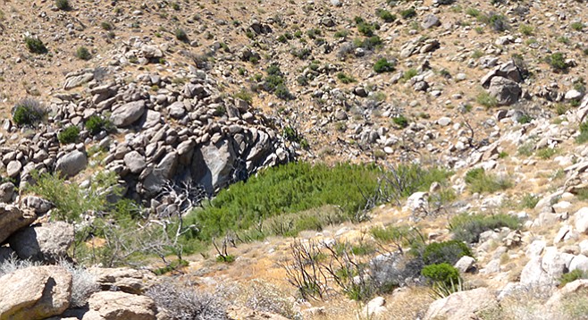
Big Spring view
Big Spring is one of the dependable watering holes for desert bighorn sheep. It is found in a tributary of upper Tubb Canyon and is easily accessible. The trail within the spring area is jungle-like with heavy vegetation. An extra treat on this hike is a slight diversion to a great view of Borrego Valley at the head of the middle fork of Tubb Canyon.
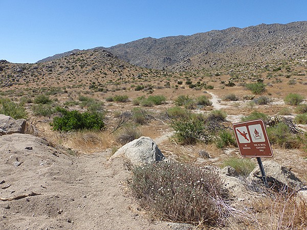
Big Spring trailhead
The trail to Big Spring departs from just south of the large turnout on S-22, crossing over a low divide into the sandy middle fork of upper Tubb Canyon and then over another low divide to the south fork of upper Tubb. Big Spring is about a mile from the highway in the latter fork and is heavily overgrown with mule-fat or seep-willow, catclaw acacia, mesquite, and cottonwood. Big Spring is a reliable water producer in the Anza-Borrego area, flowing on the shrub-choked surface for one-quarter mile, then going underground. The spring is a main watering hole for bighorn sheep and other wildlife. Look for tracks of wildlife in the area.
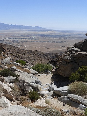
View of Borrego Valley from Big Spring
The lower canyon below the spring is on private property — do not hike down. Follow a use-trail through the vegetation to the west, taking care to avoid contact with thorny catclaw acacia and mesquite. Just above the spring are some boulders, which is a good place to rest. Dropping down from the boulders leads to the canyon bottom above the spring and below Pinyon Ridge. There is an option for exploring the upper reaches of the canyon or climbing the ridge north and dropping down to return to the main trail, which can increase the overall mileage of this hike. Otherwise, retrace your steps on the return hike.
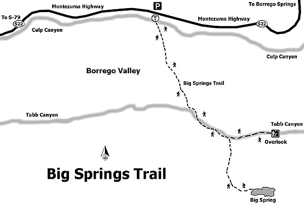
Big Spring trail map
On the way back from the spring, go over the rise to the east leading to the upper area of the middle fork of Tubb Canyon for a great view down the canyon and into Borrego Valley, about 2500 feet below.
Because this trail is at a higher elevation, it can comfortably be hiked late into the desert season, especially in the early morning or late afternoon. Like any other desert trail, be sure to carry water, wear a hat, and use sunscreen.
Big Spring
Distance from downtown San Diego: 81 miles (Anza-Borrego-Desert State Park). Allow 1.5 hours driving time. From SR-163N/I-15N, go east onto Scripps Poway Parkway to the end, then north onto SR-67. Continue east through Ramona on SR-78 to Santa Ysabel’s intersection and turn north on SR-79. Drive just past the power station before turning right onto S-2/San Felipe Road for about 5 miles, then turn left onto S-22/Montezuma Highway. Drive just past mile-marker 11 on S-22 to the large turnout on the north (left) side of the road and park. The trailhead is across the highway.
Hiking length: 2 miles out and back.
Difficulty: Easy. Elevation gain/loss 200 feet. Bicycles and dogs not allowed. No facilities.
Here's something you might be interested in.
Desert bighorn sheep big fans of Big Spring
Explore a major upper-elevation watering hole for desert wildlife
Desert bighorn sheep big fans of Big Spring
Explore a major upper-elevation watering hole for desert wildlife
Big Spring view
Big Spring is one of the dependable watering holes for desert bighorn sheep. It is found in a tributary of upper Tubb Canyon and is easily accessible. The trail within the spring area is jungle-like with heavy vegetation. An extra treat on this hike is a slight diversion to a great view of Borrego Valley at the head of the middle fork of Tubb Canyon.
Big Spring trailhead
The trail to Big Spring departs from just south of the large turnout on S-22, crossing over a low divide into the sandy middle fork of upper Tubb Canyon and then over another low divide to the south fork of upper Tubb. Big Spring is about a mile from the highway in the latter fork and is heavily overgrown with mule-fat or seep-willow, catclaw acacia, mesquite, and cottonwood. Big Spring is a reliable water producer in the Anza-Borrego area, flowing on the shrub-choked surface for one-quarter mile, then going underground. The spring is a main watering hole for bighorn sheep and other wildlife. Look for tracks of wildlife in the area.
View of Borrego Valley from Big Spring
The lower canyon below the spring is on private property — do not hike down. Follow a use-trail through the vegetation to the west, taking care to avoid contact with thorny catclaw acacia and mesquite. Just above the spring are some boulders, which is a good place to rest. Dropping down from the boulders leads to the canyon bottom above the spring and below Pinyon Ridge. There is an option for exploring the upper reaches of the canyon or climbing the ridge north and dropping down to return to the main trail, which can increase the overall mileage of this hike. Otherwise, retrace your steps on the return hike.
Big Spring trail map
On the way back from the spring, go over the rise to the east leading to the upper area of the middle fork of Tubb Canyon for a great view down the canyon and into Borrego Valley, about 2500 feet below.
Because this trail is at a higher elevation, it can comfortably be hiked late into the desert season, especially in the early morning or late afternoon. Like any other desert trail, be sure to carry water, wear a hat, and use sunscreen.
Big Spring
Distance from downtown San Diego: 81 miles (Anza-Borrego-Desert State Park). Allow 1.5 hours driving time. From SR-163N/I-15N, go east onto Scripps Poway Parkway to the end, then north onto SR-67. Continue east through Ramona on SR-78 to Santa Ysabel’s intersection and turn north on SR-79. Drive just past the power station before turning right onto S-2/San Felipe Road for about 5 miles, then turn left onto S-22/Montezuma Highway. Drive just past mile-marker 11 on S-22 to the large turnout on the north (left) side of the road and park. The trailhead is across the highway.
Hiking length: 2 miles out and back.
Difficulty: Easy. Elevation gain/loss 200 feet. Bicycles and dogs not allowed. No facilities.
Comments