Here's something you might be interested in.
Ask a Hipster — Advice you didn't know you needed
Big Screen — Movie commentary
Blurt — Music's inside track
Booze News — San Diego spirits
Classical Music — Immortal beauty
Classifieds — Free and easy
Close to Home — What it’s like on the street where you live
Cover Stories — Front-page features
Drinks All Around — Bartenders' drink recipes
Excerpts — Literary and spiritual excerpts
Feast! — Food & drink reviews
Feature Stories — Local news & stories
Fishing Report — What’s getting hooked from ship and shore
From the Archives — Spotlight on the past
Golden Dreams — Talk of the town
The Gonzo Report — Making the musical scene, or at least reporting from it
Letters — Our inbox
Movies@Home — Local movie buffs share favorites
Movie Reviews — Our critics' picks and pans
Musician Interviews — Up close with local artists
Neighborhood News from Stringers — Hyperlocal news
News Ticker — News & politics
Obermeyer — San Diego politics illustrated
Outdoors — Weekly changes in flora and fauna
Overheard in San Diego — Eavesdropping illustrated
Poetry — The old and the new
Reader Travel — Travel section built by travelers
Reading — The hunt for intellectuals
Roam-O-Rama — SoCal's best hiking/biking trails
San Diego Beer — Inside San Diego suds
SD on the QT — Almost factual news
Sheep and Goats — Places of worship
Special Issues — The best of
Street Style — San Diego streets have style
Surf Diego — Real stories from those braving the waves
Theater — On stage in San Diego this week
Tin Fork — Silver spoon alternative
Under the Radar — Matt Potter's undercover work
Unforgettable — Long-ago San Diego
Unreal Estate — San Diego's priciest pads
Your Week — Daily event picks
Waterfall to rocky summit
Bighorn sheep possible while climbing Indianhead.
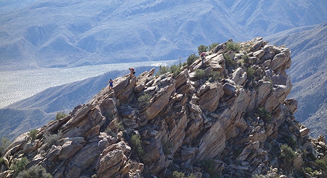
The south summit juts into the sky.
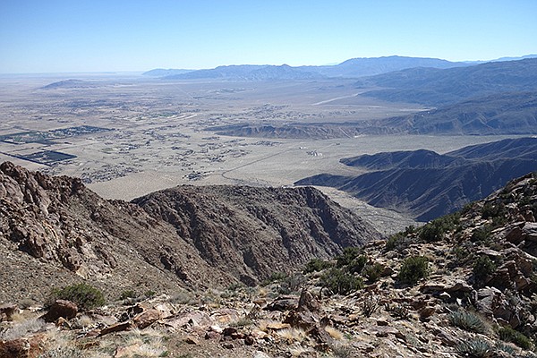
View from the Indianhead summit
Indianhead Mountain, typically referred to simply as Indianhead, is a rugged desert peak at 3990 feet elevation that defines the northern side of lower Borrego Palm Canyon. Its close proximity to Borrego Springs and Borrego Palm Canyon invites exploration for those prepared for a challenging, all day cross-country hike. Its steep, rocky slopes provide refuge for bands of threatened peninsular bighorn sheep. The summit rewards hardy hikers with incredible views of the Borrego Valley, the Santa Rosa Mountains, and the Salton Sea.
This route ascends Borrego Palm Canyon, a rare desert riparian zone and another signature feature of Anza-Borrego Desert State Park. At its base flows a year-round creek, nurturing native Washington fan palms (Washintonia filifera) that thrive along the canyon. This riparian zone begins in earnest at First Grove, which is also called Palm Oasis in state park handouts, 1.5 miles from the trailhead. A small waterfall is usually flowing here in the midst of a remnant palm grove, the largest stand of these trees in the canyon that survived a horrific summer thunderstorm flood in 2004.
Although not guaranteed, you are likely to encounter the namesake borregos, the threatened desert bighorn sheep of the peninsular range (Ovis canadensis nelsoni). These impressive animals, with males that may weigh over 200 pounds and have huge horns, have rebounded from population lows of around 200 individuals in the early 1990s. The local bighorns may be sighted at any time of the year.
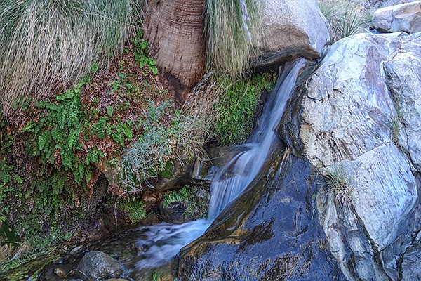
Waterfall and maidenhair ferns at Anvil of the Sun
The canyon is also home to a wide variety of resident and migratory birds, including cactus wrens, canyon wrens, loggerhead shrikes, Scott’s and Bullock’s orioles, Costa’s hummingbirds, as well as ravens, golden eagles, and prairie falcons. Gray foxes, coyotes, and signs of mountain lions may be spotted, all providing evidence that this is a notable wilderness area.
This is an out-and-back route over the same terrain in both directions, although it is possible to include the so-called “Alternate Trail” on either the descent or the ascent, providing a loop option for the lower section of the hike. Added mileage can be added by beginning the hike from the park’s visitor center, where there is no cost for parking your vehicle. Begin from the Borrego Palm Canyon trailhead, where there is a small manmade pond that hosts California tree frogs and desert pupfish.
There is a well-defined trail for the first mile and a half to First Grove with numbered sign posts corresponding to a variety of natural features described in a free pamphlet available from the visitor center. The trail crosses and follows the main creek bottom at points but is likely to be dry until nearing the grove, which is approached on the right-hand (north) side of the canyon floor. Between the trailhead and First Grove, there are hundreds of broken off palm trunks and stumps, evidence of the severity of the big flood.
Proceeding beyond First Grove, the trail climbs up and around the waterfall area on the north side, starting a hundred yards or so east of the waterfall. Beyond the grove, there are only remnants of the former trail. Drop down into the main canyon and cross over to the south side to follow the original trail, a somewhat obscure use trail since the flood of 2004. It is also possible to hike directly up the canyon, but large boulders and drop-offs can make this a tiring option. Eventually the canyon makes a sharp bend to the right, turning directly toward the steep lower south slopes of Indianhead.
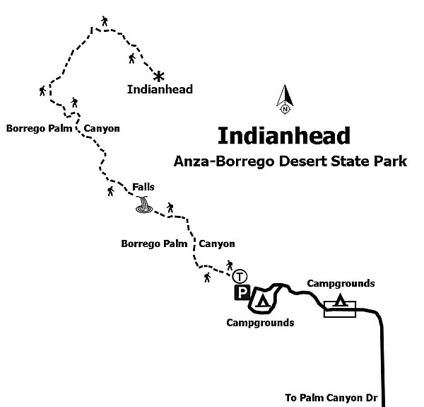
Map to Indianhead
Continue to follow faintly marked trail segments on either side of the canyon. These climb over or around large boulders. Perhaps the most distinctive obstacle before climbing out of the canyon at Third Grove is a small waterfall at the base of a large, dark red gneiss formation unofficially called “Anvil of the Sun” by some hikers. If the water is low, a short scramble leads up the right side of the waterfall chute. Otherwise, walk up and traverse this large reddish slab and descend to a ledge on its upstream side.
A standard climb-out point is near lower Third Grove. Here the route starts up the south-facing slope to reach a ridge that eventually leads to a saddle just west of Indianhead. Since the flood of 2004, only a few palms define Third Grove, but mesquite, catclaw, reeds, and other vegetation abounds. There is usually at least a small flow in the creek here.
For the rest of the hike to the summit, the climb is primarily on or near a ridge leading upward to the north. A good reference landmark on the ridge to aim for is a prominent white boulder outcrop visible from the canyon floor. Once on the ridge you will find traces of use trail and an occasional trail duck (marker). From here, continue upward to a broad saddle that divides Borrego Palm Canyon and Henderson Canyon.
After taking in your first look down the sheer north side of Indianhead, turn eastward and ascend the western ridge of the mountain, staying primarily on the ridge’s south side, watching out for loose rock and being mindful of your footing.
The upper section of this route is more easily navigated than in the past due to a large wildfire in the Los Coyotes Indian Reservation in 2011 that burned into upper Borrego Palm Canyon and here on Indianhead. There are a few large boulders to scramble around, but route options should be obvious. The last quarter-mile to the summit rocks is quite open and nearly level. A summit register is located near the highest point. Reverse the route to return.
If camping in the canyon or on the summit, no ground fires are allowed at any time. Treat or filter any water you plan on drinking from the creek. Vehicles are not allowed overnight in the visitor center parking area.
Distance from downtown San Diego: 95 or 86 miles, depending on route. Allow 2 hours driving time. The 95-mile route is via I-8 and SR-79 to Julian, then east on SR 78 to the Yaqui Pass Road (SR-3) to Borrego Springs and Christmas Circle, and then west on Palm Canyon Dr. following signs to Borrego Palm Canyon Campground. The 86-mile route is via Ramona and SR-78 east to Santa Ysabel, then north on SR-79 and right on SR-2 to the left turn on SR-22 toward Ranchita. Follow SR-22 down to the desert to Palm Canyon Dr. and turn left on Palm Canyon Dr. Follow the signs to Borrego Palm Canyon Campground. The trailhead with paved parking is at the western upper end of Borrego Palm Canyon Campground. There is an $8 day-use fee to park at the trailhead. This can be paid at the campground entrance kiosk or at a self-pay station adjacent to the kiosk.
Hiking length: 7 miles out-and-back from the trailhead or 8.8 miles from the visitor center. Allow 4 hours.
Difficulty: Strenuous to very strenuous with an elevation gain/loss of 3200 feet. Terrain is steep and rocky and involves cross-country travel. Facilities and water available at the trailhead. Dogs and mountain bikes are not allowed in the canyon or on hiking trails.
Here's something you might be interested in.
Waterfall to rocky summit
Bighorn sheep possible while climbing Indianhead.
Waterfall to rocky summit
Bighorn sheep possible while climbing Indianhead.
The south summit juts into the sky.
View from the Indianhead summit
Indianhead Mountain, typically referred to simply as Indianhead, is a rugged desert peak at 3990 feet elevation that defines the northern side of lower Borrego Palm Canyon. Its close proximity to Borrego Springs and Borrego Palm Canyon invites exploration for those prepared for a challenging, all day cross-country hike. Its steep, rocky slopes provide refuge for bands of threatened peninsular bighorn sheep. The summit rewards hardy hikers with incredible views of the Borrego Valley, the Santa Rosa Mountains, and the Salton Sea.
This route ascends Borrego Palm Canyon, a rare desert riparian zone and another signature feature of Anza-Borrego Desert State Park. At its base flows a year-round creek, nurturing native Washington fan palms (Washintonia filifera) that thrive along the canyon. This riparian zone begins in earnest at First Grove, which is also called Palm Oasis in state park handouts, 1.5 miles from the trailhead. A small waterfall is usually flowing here in the midst of a remnant palm grove, the largest stand of these trees in the canyon that survived a horrific summer thunderstorm flood in 2004.
Although not guaranteed, you are likely to encounter the namesake borregos, the threatened desert bighorn sheep of the peninsular range (Ovis canadensis nelsoni). These impressive animals, with males that may weigh over 200 pounds and have huge horns, have rebounded from population lows of around 200 individuals in the early 1990s. The local bighorns may be sighted at any time of the year.
Waterfall and maidenhair ferns at Anvil of the Sun
The canyon is also home to a wide variety of resident and migratory birds, including cactus wrens, canyon wrens, loggerhead shrikes, Scott’s and Bullock’s orioles, Costa’s hummingbirds, as well as ravens, golden eagles, and prairie falcons. Gray foxes, coyotes, and signs of mountain lions may be spotted, all providing evidence that this is a notable wilderness area.
This is an out-and-back route over the same terrain in both directions, although it is possible to include the so-called “Alternate Trail” on either the descent or the ascent, providing a loop option for the lower section of the hike. Added mileage can be added by beginning the hike from the park’s visitor center, where there is no cost for parking your vehicle. Begin from the Borrego Palm Canyon trailhead, where there is a small manmade pond that hosts California tree frogs and desert pupfish.
There is a well-defined trail for the first mile and a half to First Grove with numbered sign posts corresponding to a variety of natural features described in a free pamphlet available from the visitor center. The trail crosses and follows the main creek bottom at points but is likely to be dry until nearing the grove, which is approached on the right-hand (north) side of the canyon floor. Between the trailhead and First Grove, there are hundreds of broken off palm trunks and stumps, evidence of the severity of the big flood.
Proceeding beyond First Grove, the trail climbs up and around the waterfall area on the north side, starting a hundred yards or so east of the waterfall. Beyond the grove, there are only remnants of the former trail. Drop down into the main canyon and cross over to the south side to follow the original trail, a somewhat obscure use trail since the flood of 2004. It is also possible to hike directly up the canyon, but large boulders and drop-offs can make this a tiring option. Eventually the canyon makes a sharp bend to the right, turning directly toward the steep lower south slopes of Indianhead.
Map to Indianhead
Continue to follow faintly marked trail segments on either side of the canyon. These climb over or around large boulders. Perhaps the most distinctive obstacle before climbing out of the canyon at Third Grove is a small waterfall at the base of a large, dark red gneiss formation unofficially called “Anvil of the Sun” by some hikers. If the water is low, a short scramble leads up the right side of the waterfall chute. Otherwise, walk up and traverse this large reddish slab and descend to a ledge on its upstream side.
A standard climb-out point is near lower Third Grove. Here the route starts up the south-facing slope to reach a ridge that eventually leads to a saddle just west of Indianhead. Since the flood of 2004, only a few palms define Third Grove, but mesquite, catclaw, reeds, and other vegetation abounds. There is usually at least a small flow in the creek here.
For the rest of the hike to the summit, the climb is primarily on or near a ridge leading upward to the north. A good reference landmark on the ridge to aim for is a prominent white boulder outcrop visible from the canyon floor. Once on the ridge you will find traces of use trail and an occasional trail duck (marker). From here, continue upward to a broad saddle that divides Borrego Palm Canyon and Henderson Canyon.
After taking in your first look down the sheer north side of Indianhead, turn eastward and ascend the western ridge of the mountain, staying primarily on the ridge’s south side, watching out for loose rock and being mindful of your footing.
The upper section of this route is more easily navigated than in the past due to a large wildfire in the Los Coyotes Indian Reservation in 2011 that burned into upper Borrego Palm Canyon and here on Indianhead. There are a few large boulders to scramble around, but route options should be obvious. The last quarter-mile to the summit rocks is quite open and nearly level. A summit register is located near the highest point. Reverse the route to return.
If camping in the canyon or on the summit, no ground fires are allowed at any time. Treat or filter any water you plan on drinking from the creek. Vehicles are not allowed overnight in the visitor center parking area.
Distance from downtown San Diego: 95 or 86 miles, depending on route. Allow 2 hours driving time. The 95-mile route is via I-8 and SR-79 to Julian, then east on SR 78 to the Yaqui Pass Road (SR-3) to Borrego Springs and Christmas Circle, and then west on Palm Canyon Dr. following signs to Borrego Palm Canyon Campground. The 86-mile route is via Ramona and SR-78 east to Santa Ysabel, then north on SR-79 and right on SR-2 to the left turn on SR-22 toward Ranchita. Follow SR-22 down to the desert to Palm Canyon Dr. and turn left on Palm Canyon Dr. Follow the signs to Borrego Palm Canyon Campground. The trailhead with paved parking is at the western upper end of Borrego Palm Canyon Campground. There is an $8 day-use fee to park at the trailhead. This can be paid at the campground entrance kiosk or at a self-pay station adjacent to the kiosk.
Hiking length: 7 miles out-and-back from the trailhead or 8.8 miles from the visitor center. Allow 4 hours.
Difficulty: Strenuous to very strenuous with an elevation gain/loss of 3200 feet. Terrain is steep and rocky and involves cross-country travel. Facilities and water available at the trailhead. Dogs and mountain bikes are not allowed in the canyon or on hiking trails.
Comments