Here's something you might be interested in.
Ask a Hipster — Advice you didn't know you needed
Big Screen — Movie commentary
Blurt — Music's inside track
Booze News — San Diego spirits
Classical Music — Immortal beauty
Classifieds — Free and easy
Close to Home — What it’s like on the street where you live
Cover Stories — Front-page features
Drinks All Around — Bartenders' drink recipes
Excerpts — Literary and spiritual excerpts
Feast! — Food & drink reviews
Feature Stories — Local news & stories
Fishing Report — What’s getting hooked from ship and shore
From the Archives — Spotlight on the past
Golden Dreams — Talk of the town
The Gonzo Report — Making the musical scene, or at least reporting from it
Letters — Our inbox
Movies@Home — Local movie buffs share favorites
Movie Reviews — Our critics' picks and pans
Musician Interviews — Up close with local artists
Neighborhood News from Stringers — Hyperlocal news
News Ticker — News & politics
Obermeyer — San Diego politics illustrated
Outdoors — Weekly changes in flora and fauna
Overheard in San Diego — Eavesdropping illustrated
Poetry — The old and the new
Reader Travel — Travel section built by travelers
Reading — The hunt for intellectuals
Roam-O-Rama — SoCal's best hiking/biking trails
San Diego Beer — Inside San Diego suds
SD on the QT — Almost factual news
Sheep and Goats — Places of worship
Special Issues — The best of
Street Style — San Diego streets have style
Surf Diego — Real stories from those braving the waves
Theater — On stage in San Diego this week
Tin Fork — Silver spoon alternative
Under the Radar — Matt Potter's undercover work
Unforgettable — Long-ago San Diego
Unreal Estate — San Diego's priciest pads
Your Week — Daily event picks
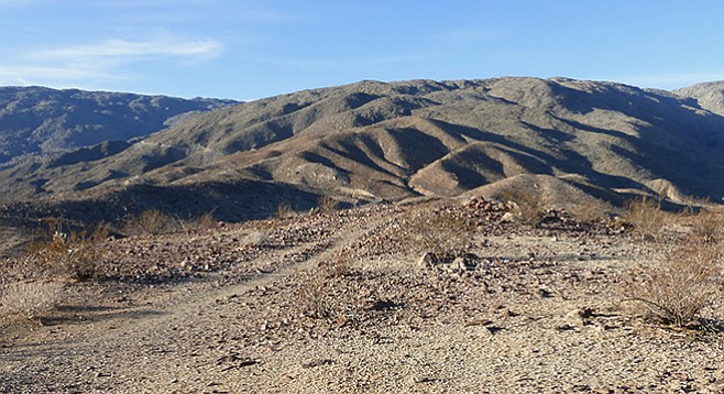
Geology in motion
A good place to peer into Hellhole Canyon
Cleared area next to the trail may have been used by Native Americans
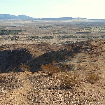
As the trail heads down to the east, Fonts Point is visible.
The name of this spur may be due to its eastern end, which has several churches located on or near a street called Church Lane. There is also an annual Easter Sunrise Service held outside along a lower ridge of the spur that has nice views of Borrego Valley. Perhaps it was the view from the spur that caused the original planners of the town to consider routing the Montezuma Highway down to its eastern end. In fact, the front of the Borrego Springs mall was to face the road entering Borrego Springs. The mall was constructed based on the original road plans. When the road plans were modified to its present location, motorists were forced to approach the mall on Palm Canyon Drive from what was supposed to have been the back side.
Geologically, Church Spur is complex, with forces from the late Tertiary Period to the present responsible for detachment faulting in the San Ysidro Mountain block found along Church Spur. This locale may have begun slipping from the main mountain block when compression and detachment faulting began along the San Jacinto Fault Zone and along the Salton trough. Church Spur is a product of fault slip and motion due to the force of gravity into the Salton Trough. Tremendous pressure within this area has caused some igneous rocks to be metamorphosed into schists and other rocks. Today the spur extends into the valley.
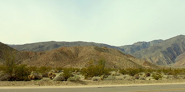
Church Spur, west end
The hike begins after carefully crossing the Montezuma Highway, which straddles Church Spur. Head due east to the mountain block 0.1 mile ahead, passing ocotillos, lavender, cacti, and brittlebush. Look for the traces of an old jeep road and follow the rutted trail to the right up to the high point of this loop hike at 0.73 mile from the start. As you climb the hill, note the growth of barrel cactus, cholla, indigo plant, and creosote. This high point is a good place to contemplate how this spur moved down from its mountain block. It is also a good place to peer into Hellhole Canyon, a popular hiking area with palm groves and a waterfall during wet years. Look around this high point and note some of the cleared areas that could possibly indicate Native American use as areas for shelters or hunting blinds.
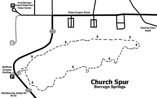
Church Spur trail map
Follow the winding trail up and down along the ridge, enjoying the view of Borrego Valley. At mile 1.12, look to the south toward Sunset Mountain and down to view the new University of California, Irvine, field station, where students and researchers are learning more about our desert. This area of the ridge has some cross trails. Follow trails that tend north and east. At mile 1.5, the trail begins a rapid descent to the valley floor at mile 1.86. From here, turn west and follow an old jeep trail around the ridge to complete the loop.
Distance from downtown San Diego: 90 miles. Allow 2 hours driving time. Drive to Ramona and follow SR-78 E 15 miles to Santa Ysabel. Turn north (left) on SR-79, and after 11 miles, turn southeast (right) onto S-2 (San Felipe Road). At the turn-off for S-22 (Montezuma Valley Road), turn east (left) and follow S-22 to the bottom of the grade, watching for the turn to the west (left) into the Hellhole Canyon parking area at milepost 16.5. The trailhead is on the east side of the highway, directly across from the entrance to Hellhole.
Hiking length: 3.2-mile loop. Allow 2 hours.
Difficulty: Moderately strenuous because it is rocky and there are steep ascents and descents with an elevation gain/loss of 500 feet. There are vault toilets at Hellhole parking area but no water. Dogs are allowed, as this ridge is not within the state park.
Here's something you might be interested in.
Geology in motion
A good place to peer into Hellhole Canyon
Geology in motion
A good place to peer into Hellhole Canyon
Cleared area next to the trail may have been used by Native Americans
As the trail heads down to the east, Fonts Point is visible.
The name of this spur may be due to its eastern end, which has several churches located on or near a street called Church Lane. There is also an annual Easter Sunrise Service held outside along a lower ridge of the spur that has nice views of Borrego Valley. Perhaps it was the view from the spur that caused the original planners of the town to consider routing the Montezuma Highway down to its eastern end. In fact, the front of the Borrego Springs mall was to face the road entering Borrego Springs. The mall was constructed based on the original road plans. When the road plans were modified to its present location, motorists were forced to approach the mall on Palm Canyon Drive from what was supposed to have been the back side.
Geologically, Church Spur is complex, with forces from the late Tertiary Period to the present responsible for detachment faulting in the San Ysidro Mountain block found along Church Spur. This locale may have begun slipping from the main mountain block when compression and detachment faulting began along the San Jacinto Fault Zone and along the Salton trough. Church Spur is a product of fault slip and motion due to the force of gravity into the Salton Trough. Tremendous pressure within this area has caused some igneous rocks to be metamorphosed into schists and other rocks. Today the spur extends into the valley.
Church Spur, west end
The hike begins after carefully crossing the Montezuma Highway, which straddles Church Spur. Head due east to the mountain block 0.1 mile ahead, passing ocotillos, lavender, cacti, and brittlebush. Look for the traces of an old jeep road and follow the rutted trail to the right up to the high point of this loop hike at 0.73 mile from the start. As you climb the hill, note the growth of barrel cactus, cholla, indigo plant, and creosote. This high point is a good place to contemplate how this spur moved down from its mountain block. It is also a good place to peer into Hellhole Canyon, a popular hiking area with palm groves and a waterfall during wet years. Look around this high point and note some of the cleared areas that could possibly indicate Native American use as areas for shelters or hunting blinds.
Church Spur trail map
Follow the winding trail up and down along the ridge, enjoying the view of Borrego Valley. At mile 1.12, look to the south toward Sunset Mountain and down to view the new University of California, Irvine, field station, where students and researchers are learning more about our desert. This area of the ridge has some cross trails. Follow trails that tend north and east. At mile 1.5, the trail begins a rapid descent to the valley floor at mile 1.86. From here, turn west and follow an old jeep trail around the ridge to complete the loop.
Distance from downtown San Diego: 90 miles. Allow 2 hours driving time. Drive to Ramona and follow SR-78 E 15 miles to Santa Ysabel. Turn north (left) on SR-79, and after 11 miles, turn southeast (right) onto S-2 (San Felipe Road). At the turn-off for S-22 (Montezuma Valley Road), turn east (left) and follow S-22 to the bottom of the grade, watching for the turn to the west (left) into the Hellhole Canyon parking area at milepost 16.5. The trailhead is on the east side of the highway, directly across from the entrance to Hellhole.
Hiking length: 3.2-mile loop. Allow 2 hours.
Difficulty: Moderately strenuous because it is rocky and there are steep ascents and descents with an elevation gain/loss of 500 feet. There are vault toilets at Hellhole parking area but no water. Dogs are allowed, as this ridge is not within the state park.