Here's something you might be interested in.
Ask a Hipster — Advice you didn't know you needed
Big Screen — Movie commentary
Blurt — Music's inside track
Booze News — San Diego spirits
Classical Music — Immortal beauty
Classifieds — Free and easy
Close to Home — What it’s like on the street where you live
Cover Stories — Front-page features
Drinks All Around — Bartenders' drink recipes
Excerpts — Literary and spiritual excerpts
Feast! — Food & drink reviews
Feature Stories — Local news & stories
Fishing Report — What’s getting hooked from ship and shore
From the Archives — Spotlight on the past
Golden Dreams — Talk of the town
The Gonzo Report — Making the musical scene, or at least reporting from it
Letters — Our inbox
Movies@Home — Local movie buffs share favorites
Movie Reviews — Our critics' picks and pans
Musician Interviews — Up close with local artists
Neighborhood News from Stringers — Hyperlocal news
News Ticker — News & politics
Obermeyer — San Diego politics illustrated
Outdoors — Weekly changes in flora and fauna
Overheard in San Diego — Eavesdropping illustrated
Poetry — The old and the new
Reader Travel — Travel section built by travelers
Reading — The hunt for intellectuals
Roam-O-Rama — SoCal's best hiking/biking trails
San Diego Beer — Inside San Diego suds
SD on the QT — Almost factual news
Sheep and Goats — Places of worship
Special Issues — The best of
Street Style — San Diego streets have style
Surf Diego — Real stories from those braving the waves
Theater — On stage in San Diego this week
Tin Fork — Silver spoon alternative
Under the Radar — Matt Potter's undercover work
Unforgettable — Long-ago San Diego
Unreal Estate — San Diego's priciest pads
Your Week — Daily event picks
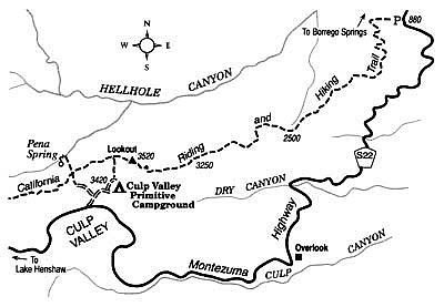
Descend from the high desert to low desert on Anza-Borrego's California Riding and Hiking Trail.
The old, never-completed California Riding and Hiking Trail, pieced out of dirt roadways and previously existing trails during the post-World War II years, has never quite disappeared from San Diego County. One branch of this erstwhile trail splits from its main north-south strand in the Cuyamaca Mountains and leads over desert hill and dale toward Borrego Valley. One of the better-maintained sections descends from Ranchita, high on the west rim of the Anza-Borrego Desert, toward Borrego Springs. Treading this narrow pathway, you follow in the prehistoric footsteps of Native Americans, whose seasonal migrations between the winter warmth of the desert and the summer coolness of the mountains made feasible their hunter-gatherer existence. For several decades during the early 20th Century, the same route was used by cattlemen driving herds from the Mesa Grande area near Lake Henshaw to winter and springtime grazing grounds in Borrego Valley.
The somewhat abbreviated five-mile stretch of the trail I describe here is best done as a one-way, downhill hike. Devise a car-shuttle arrangement, or have someone drop you off at the start and later pick you up at the finish. The terrain is rough and rocky, so wear shoes or boots with ankle support.
Start walking at the north end of the Culp Valley Campground, which is found just north of Montezuma Highway (County S-22) between mile markers 9.0 and 9.5. Walk north 0.2 mile along the signed trail to the "Lookout" or vista point on the rim of Culp Valley, and veer right as the west branch of the riding and hiking trail joins from the left. Proceed up and over the nearby rounded hill (elevation 3520 feet) dubbed the Lookout.
Once past the Lookout, you thread your way downward along the undulating stair-step divide separating the shallow drainage of Dry Canyon from the deeper cleft of Hellhole Canyon. The pseudo-chaparral vegetation you saw at first grades into a low-desert type of vegetation -- mostly ocotillo, creosote bush, and brittlebush. When in full bloom this month and next, the brittlebush spreads patches of yellow across the stony slopes. On the clearer days, the near and far views of desert valleys and mountains are consistently stunning all the way down. The last mile of the hike features an unusually steep descent to the desert floor near the mouth of Hellhole Canyon. Turn right as the trail reaches near-level ground, and walk over to the major trailhead/staging area on Montezuma Highway, 0.7 mile south of Palm Canyon Drive, just outside Borrego Springs.
Here's something you might be interested in.
Descend from the high desert to low desert on Anza-Borrego's California Riding and Hiking Trail.
Descend from the high desert to low desert on Anza-Borrego's California Riding and Hiking Trail.
The old, never-completed California Riding and Hiking Trail, pieced out of dirt roadways and previously existing trails during the post-World War II years, has never quite disappeared from San Diego County. One branch of this erstwhile trail splits from its main north-south strand in the Cuyamaca Mountains and leads over desert hill and dale toward Borrego Valley. One of the better-maintained sections descends from Ranchita, high on the west rim of the Anza-Borrego Desert, toward Borrego Springs. Treading this narrow pathway, you follow in the prehistoric footsteps of Native Americans, whose seasonal migrations between the winter warmth of the desert and the summer coolness of the mountains made feasible their hunter-gatherer existence. For several decades during the early 20th Century, the same route was used by cattlemen driving herds from the Mesa Grande area near Lake Henshaw to winter and springtime grazing grounds in Borrego Valley.
The somewhat abbreviated five-mile stretch of the trail I describe here is best done as a one-way, downhill hike. Devise a car-shuttle arrangement, or have someone drop you off at the start and later pick you up at the finish. The terrain is rough and rocky, so wear shoes or boots with ankle support.
Start walking at the north end of the Culp Valley Campground, which is found just north of Montezuma Highway (County S-22) between mile markers 9.0 and 9.5. Walk north 0.2 mile along the signed trail to the "Lookout" or vista point on the rim of Culp Valley, and veer right as the west branch of the riding and hiking trail joins from the left. Proceed up and over the nearby rounded hill (elevation 3520 feet) dubbed the Lookout.
Once past the Lookout, you thread your way downward along the undulating stair-step divide separating the shallow drainage of Dry Canyon from the deeper cleft of Hellhole Canyon. The pseudo-chaparral vegetation you saw at first grades into a low-desert type of vegetation -- mostly ocotillo, creosote bush, and brittlebush. When in full bloom this month and next, the brittlebush spreads patches of yellow across the stony slopes. On the clearer days, the near and far views of desert valleys and mountains are consistently stunning all the way down. The last mile of the hike features an unusually steep descent to the desert floor near the mouth of Hellhole Canyon. Turn right as the trail reaches near-level ground, and walk over to the major trailhead/staging area on Montezuma Highway, 0.7 mile south of Palm Canyon Drive, just outside Borrego Springs.