Here's something you might be interested in.
Ask a Hipster — Advice you didn't know you needed
Big Screen — Movie commentary
Blurt — Music's inside track
Booze News — San Diego spirits
Classical Music — Immortal beauty
Classifieds — Free and easy
Close to Home — What it’s like on the street where you live
Cover Stories — Front-page features
Drinks All Around — Bartenders' drink recipes
Excerpts — Literary and spiritual excerpts
Feast! — Food & drink reviews
Feature Stories — Local news & stories
Fishing Report — What’s getting hooked from ship and shore
From the Archives — Spotlight on the past
Golden Dreams — Talk of the town
The Gonzo Report — Making the musical scene, or at least reporting from it
Letters — Our inbox
Movies@Home — Local movie buffs share favorites
Movie Reviews — Our critics' picks and pans
Musician Interviews — Up close with local artists
Neighborhood News from Stringers — Hyperlocal news
News Ticker — News & politics
Obermeyer — San Diego politics illustrated
Outdoors — Weekly changes in flora and fauna
Overheard in San Diego — Eavesdropping illustrated
Poetry — The old and the new
Reader Travel — Travel section built by travelers
Reading — The hunt for intellectuals
Roam-O-Rama — SoCal's best hiking/biking trails
San Diego Beer — Inside San Diego suds
SD on the QT — Almost factual news
Sheep and Goats — Places of worship
Special Issues — The best of
Street Style — San Diego streets have style
Surf Diego — Real stories from those braving the waves
Theater — On stage in San Diego this week
Tin Fork — Silver spoon alternative
Under the Radar — Matt Potter's undercover work
Unforgettable — Long-ago San Diego
Unreal Estate — San Diego's priciest pads
Your Week — Daily event picks
Coyote Canyon and Rockhouse Canyon, once home to Coyote people, traveled to the territory of cat people to find marriage partners
Discover a hidden playa filled with landslide alluvium
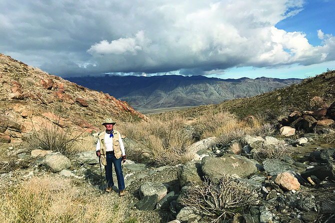
Heading upcanyon toward the playa
Coyote Mountain is sandwiched between the Coyote Creek fault and the Coyote Mountain/Clark Lake fault within the San Jacinto Fault Zone. Pressure from these right-lateral faults has caused the uplift creating Coyote Mountain and the resultant rock-block landslide areas found at Alcoholic Pass, Coyote Ridge, Coyote Peak, and the Pegleg Smith landslide complex. The eastern half of the mountain, from Coyote Peak to the Pegleg Smith Monument, makes up the Coyote Mountain cataclastic zone, where plutonic and pre-batholithic rocks have been subjected to deformation and east-dipping shear foliation. This is a great place to view twisted and folded metamorphic rocks among outcrops of granitic rocks, poorly consolidated terrestrial sands, and conglomerates that have accumulated in coalescing basins and fan environments.
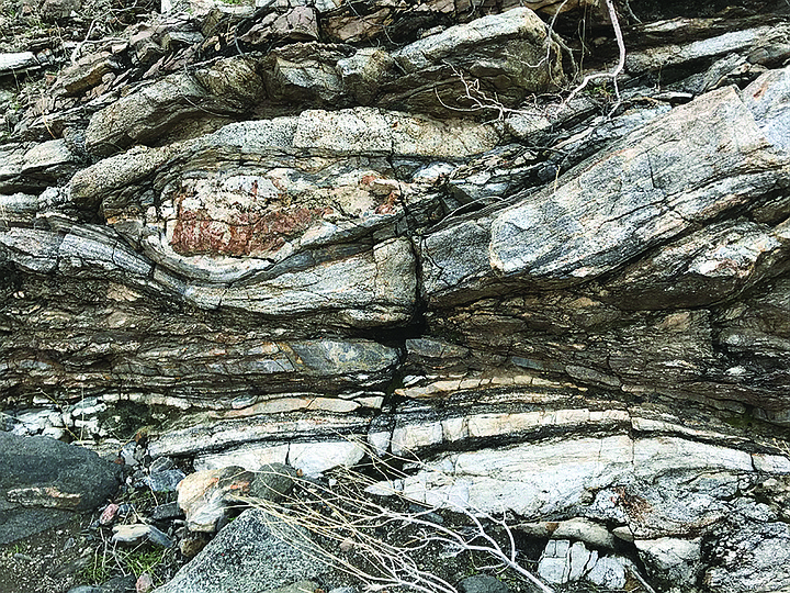
Typical gneiss metamorphic rock formed under high pressure and temperature
The playa, the feature of this hike, is ponded alluvium in a side-hill valley located below a scarp. A landslide dam filled in the ephemeral lake that was in this valley, and it’s now completely filled with about 150 feet of alluvium. Drainage flows into Clark Valley. The route into the playa passes the walls of this landslide dam. Notable on this hike is the variety of rocks and their colors. There are slabs of gneiss, some limestone with rust-like colors, plenty of pegmatite dikes, broken pieces of colorful quartz, granitics with hornblende, and some marble.
Begin the hike either at the fence at mile 1.6 or along the road at mile 2.0. Head west to the canyon mouth just beyond the jutting ridge sitting above the canyon fan. Carefully work your way up canyon, being sure to take the two left turns in the canyon that will lead to the playa. It becomes very boulderly after the first left turn and extra caution should be used moving slowly uphill. As there is no trail, pick you way upward as best you can. After the second left turn, the landslide dam becomes visible and is in high contrast to the rocky mountainsides with its sandy features. After a few more turns in the canyon, the entrance to the playa becomes visible: a total surprise in its size and flat feature, surrounded by higher walls. This is a good place to rest and contemplate earth movement in this area.
Plants found on this hike are typical of the area and include creosote, cheesebush, brittlebush, and catclaw acacia.
The mountain is named not for the canid coyote but rather for the Cahuilla band of Indians that once lived in this area. The tribe is divided into two moiety groups, cat and coyote, which make sure that there is not close inbreeding. Coyote people, who once lived in Coyote Canyon and Rockhouse Canyon, had to travel to the territory of cat people to find marriage partners. Cahuilla, who lived in the Banning, Palm Springs, and Indio area, are cat people.
This Coyote Mountain is sometimes confused with the Coyote Mountains in the southern Anza-Borrego desert region. Those mountains were, indeed, named for the wily coyote who does roam the area.
COYOTE MOUNTAIN PLAYA (Anza-Borrego Desert State Park)
Discover a hidden playa filled with landslide alluvium.
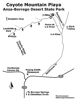
Coyote Mountain Playa map
Driving directions: (Borrego Springs) Drive to Christmas Circle in Borrego Springs via Ranchita or Julian. Allow 2 hours from downtown San Diego. From Christmas Circle, drive east 7.2 miles on S-22, and turn north (left) on Rockhouse Trail. Set odometer to zero. Drive 1.4 miles on Rockhouse Trail to a fork on the left heading northwest. This is a dirt road that parallels the main Rockhouse Trail to the southeast. At 1.6 miles is a fence. You can park here and begin hiking, but it will add 0.5 mile to the hike. For a 3-mile hike, drive to 2.0 miles and park. Hiking length: Minimum 3 miles. Allow 2-3 hours. Difficulty: Moderately strenuous because of boulders in one section of the canyon. 520 feet elevation gain. Need trekking poles for safety. No trail. No facilities.
Here's something you might be interested in.
Coyote Canyon and Rockhouse Canyon, once home to Coyote people, traveled to the territory of cat people to find marriage partners
Discover a hidden playa filled with landslide alluvium
Coyote Canyon and Rockhouse Canyon, once home to Coyote people, traveled to the territory of cat people to find marriage partners
Discover a hidden playa filled with landslide alluvium
Heading upcanyon toward the playa
Coyote Mountain is sandwiched between the Coyote Creek fault and the Coyote Mountain/Clark Lake fault within the San Jacinto Fault Zone. Pressure from these right-lateral faults has caused the uplift creating Coyote Mountain and the resultant rock-block landslide areas found at Alcoholic Pass, Coyote Ridge, Coyote Peak, and the Pegleg Smith landslide complex. The eastern half of the mountain, from Coyote Peak to the Pegleg Smith Monument, makes up the Coyote Mountain cataclastic zone, where plutonic and pre-batholithic rocks have been subjected to deformation and east-dipping shear foliation. This is a great place to view twisted and folded metamorphic rocks among outcrops of granitic rocks, poorly consolidated terrestrial sands, and conglomerates that have accumulated in coalescing basins and fan environments.
Typical gneiss metamorphic rock formed under high pressure and temperature
The playa, the feature of this hike, is ponded alluvium in a side-hill valley located below a scarp. A landslide dam filled in the ephemeral lake that was in this valley, and it’s now completely filled with about 150 feet of alluvium. Drainage flows into Clark Valley. The route into the playa passes the walls of this landslide dam. Notable on this hike is the variety of rocks and their colors. There are slabs of gneiss, some limestone with rust-like colors, plenty of pegmatite dikes, broken pieces of colorful quartz, granitics with hornblende, and some marble.
Begin the hike either at the fence at mile 1.6 or along the road at mile 2.0. Head west to the canyon mouth just beyond the jutting ridge sitting above the canyon fan. Carefully work your way up canyon, being sure to take the two left turns in the canyon that will lead to the playa. It becomes very boulderly after the first left turn and extra caution should be used moving slowly uphill. As there is no trail, pick you way upward as best you can. After the second left turn, the landslide dam becomes visible and is in high contrast to the rocky mountainsides with its sandy features. After a few more turns in the canyon, the entrance to the playa becomes visible: a total surprise in its size and flat feature, surrounded by higher walls. This is a good place to rest and contemplate earth movement in this area.
Plants found on this hike are typical of the area and include creosote, cheesebush, brittlebush, and catclaw acacia.
The mountain is named not for the canid coyote but rather for the Cahuilla band of Indians that once lived in this area. The tribe is divided into two moiety groups, cat and coyote, which make sure that there is not close inbreeding. Coyote people, who once lived in Coyote Canyon and Rockhouse Canyon, had to travel to the territory of cat people to find marriage partners. Cahuilla, who lived in the Banning, Palm Springs, and Indio area, are cat people.
This Coyote Mountain is sometimes confused with the Coyote Mountains in the southern Anza-Borrego desert region. Those mountains were, indeed, named for the wily coyote who does roam the area.
COYOTE MOUNTAIN PLAYA (Anza-Borrego Desert State Park)
Discover a hidden playa filled with landslide alluvium.
Coyote Mountain Playa map
Driving directions: (Borrego Springs) Drive to Christmas Circle in Borrego Springs via Ranchita or Julian. Allow 2 hours from downtown San Diego. From Christmas Circle, drive east 7.2 miles on S-22, and turn north (left) on Rockhouse Trail. Set odometer to zero. Drive 1.4 miles on Rockhouse Trail to a fork on the left heading northwest. This is a dirt road that parallels the main Rockhouse Trail to the southeast. At 1.6 miles is a fence. You can park here and begin hiking, but it will add 0.5 mile to the hike. For a 3-mile hike, drive to 2.0 miles and park. Hiking length: Minimum 3 miles. Allow 2-3 hours. Difficulty: Moderately strenuous because of boulders in one section of the canyon. 520 feet elevation gain. Need trekking poles for safety. No trail. No facilities.
Comments