Here's something you might be interested in.
Ask a Hipster — Advice you didn't know you needed
Big Screen — Movie commentary
Blurt — Music's inside track
Booze News — San Diego spirits
Classical Music — Immortal beauty
Classifieds — Free and easy
Close to Home — What it’s like on the street where you live
Cover Stories — Front-page features
Drinks All Around — Bartenders' drink recipes
Excerpts — Literary and spiritual excerpts
Feast! — Food & drink reviews
Feature Stories — Local news & stories
Fishing Report — What’s getting hooked from ship and shore
From the Archives — Spotlight on the past
Golden Dreams — Talk of the town
The Gonzo Report — Making the musical scene, or at least reporting from it
Letters — Our inbox
Movies@Home — Local movie buffs share favorites
Movie Reviews — Our critics' picks and pans
Musician Interviews — Up close with local artists
Neighborhood News from Stringers — Hyperlocal news
News Ticker — News & politics
Obermeyer — San Diego politics illustrated
Outdoors — Weekly changes in flora and fauna
Overheard in San Diego — Eavesdropping illustrated
Poetry — The old and the new
Reader Travel — Travel section built by travelers
Reading — The hunt for intellectuals
Roam-O-Rama — SoCal's best hiking/biking trails
San Diego Beer — Inside San Diego suds
SD on the QT — Almost factual news
Sheep and Goats — Places of worship
Special Issues — The best of
Street Style — San Diego streets have style
Surf Diego — Real stories from those braving the waves
Theater — On stage in San Diego this week
Tin Fork — Silver spoon alternative
Under the Radar — Matt Potter's undercover work
Unforgettable — Long-ago San Diego
Unreal Estate — San Diego's priciest pads
Your Week — Daily event picks
Boulder-hop for miles to reach one of the tallest waterfalls in Southern California.
Boulder-hop for miles to reach one of the tallest waterfalls in Southern California.
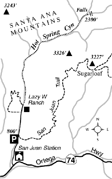
The hike up Hot Spring Canyon is arguably the most beautiful canyon trek in the Santa Ana Mountains, and supremely arduous to boot. The goal is a magnificent 140-foot-high waterfall, the highest by far in Orange County.
Being in excellent physical condition, having considerable experience in cross-country travel over rugged terrain, and possessing good judgment do not automatically guarantee that you'll be able to reach the falls and return on time and without mishap. You must be cautious, patient, agile, strong, and determined. Hazards include slippery rocks (some concealed by leaf litter), prickly vegetation, and forests of poison oak. Long pants, a long-sleeved shirt, and sturdy boots are musts.
December might be a good time to attempt this hike, but if the peak of the rainy season comes later, there won't be much water cascading over the falls or flowing down the creek. Wildflowers and new leaves in early spring add to the canyon's beauty, but by then the ubiquitous poison oak bushes and vines are sporting fresh, virulent leaves, and rattlesnakes are emerging from their winter burrows. Fair-weather days January through February are probably best. Be sure to start very early in the morning to take advantage of the limited daylight.
A portion of this route unavoidably passes through an inholding of private land in the Cleveland National Forest -- the Lazy W Ranch, a church camp. You must ask for permission to hike through the property in advance. Contact the church camp: P.O. Box 579, San Juan Capistrano, CA 92675; 949-728-0141; lazywranch.org. The caretaker may ask that you inform someone of your safe return on your way out.
Parking is not allowed at the church camp and is very limited near the camp's entrance, so leave your car at the trailhead for the San Juan Trail, 0.8 mile north of Ortega Highway (and about ten miles east of San Juan Capistrano). Walk 0.6 mile north to the church camp entrance, then continue another 0.3 mile past several buildings. Stay close to the Hot Spring Canyon stream, and continue up an old roadbed flanked on both sides by huge, spreading coast live oak trees.
By 1.5 miles (from your car), the route deteriorates to little more than a wildlife trail. The creek bubbles alongside, with scattered sycamores and alders growing from the granite-bouldered banks. At 2.0 miles, the canyon makes a decided turn to the northeast. From this point on, dark brownish and grayish metamorphic rocks gradually replace the granites, and the canyon becomes considerably narrower. Progress becomes much slower. You must choose between battling thickets of willow, sage, wild blackberry, and poison oak on the banks, or rock-hopping and sloshing through the creek while dodging nettles and alder branches. Here and there the creek may disappear under porous sands for brief stretches.
At 3.4 miles (1620 feet), the creek slides over a series of granite slabs and collects in limpid pools almost perennially shaded by an overhanging south wall. Just beyond, the canyon broadens, and a usually wet tributary comes in on the right. At 4.1 miles (1950 feet), another usually wet tributary joins on the left; a 70-foot waterfall with a scant flow lies immediately up this tributary from the main canyon.
By now, it should be possible to glimpse, just 200 yards ahead, the top of a sheer headwall. From the lip, water plunges some 140 feet down two distinct tiers. Boulder-hopping will get you to the base of a much smaller fall (a moss-covered 20-footer) just below the bottom of the big one. Further progress up the canyon is possible only by some dicey hand-and-toe climbing.
Don't linger long. The trip back down the canyon, owing to fatigue, may take just as much time as your approach did.
This article contains information about a publicly owned recreation or wilderness area. Trails and pathways are not necessarily marked. Conditions can change rapidly. Hikers should be properly equipped and have safety and navigational skills. The Reader and Jerry Schad assume no responsibility for any adverse experience.
Here's something you might be interested in.
Boulder-hop for miles to reach one of the tallest waterfalls in Southern California.
Boulder-hop for miles to reach one of the tallest waterfalls in Southern California.
Boulder-hop for miles to reach one of the tallest waterfalls in Southern California.
The hike up Hot Spring Canyon is arguably the most beautiful canyon trek in the Santa Ana Mountains, and supremely arduous to boot. The goal is a magnificent 140-foot-high waterfall, the highest by far in Orange County.
Being in excellent physical condition, having considerable experience in cross-country travel over rugged terrain, and possessing good judgment do not automatically guarantee that you'll be able to reach the falls and return on time and without mishap. You must be cautious, patient, agile, strong, and determined. Hazards include slippery rocks (some concealed by leaf litter), prickly vegetation, and forests of poison oak. Long pants, a long-sleeved shirt, and sturdy boots are musts.
December might be a good time to attempt this hike, but if the peak of the rainy season comes later, there won't be much water cascading over the falls or flowing down the creek. Wildflowers and new leaves in early spring add to the canyon's beauty, but by then the ubiquitous poison oak bushes and vines are sporting fresh, virulent leaves, and rattlesnakes are emerging from their winter burrows. Fair-weather days January through February are probably best. Be sure to start very early in the morning to take advantage of the limited daylight.
A portion of this route unavoidably passes through an inholding of private land in the Cleveland National Forest -- the Lazy W Ranch, a church camp. You must ask for permission to hike through the property in advance. Contact the church camp: P.O. Box 579, San Juan Capistrano, CA 92675; 949-728-0141; lazywranch.org. The caretaker may ask that you inform someone of your safe return on your way out.
Parking is not allowed at the church camp and is very limited near the camp's entrance, so leave your car at the trailhead for the San Juan Trail, 0.8 mile north of Ortega Highway (and about ten miles east of San Juan Capistrano). Walk 0.6 mile north to the church camp entrance, then continue another 0.3 mile past several buildings. Stay close to the Hot Spring Canyon stream, and continue up an old roadbed flanked on both sides by huge, spreading coast live oak trees.
By 1.5 miles (from your car), the route deteriorates to little more than a wildlife trail. The creek bubbles alongside, with scattered sycamores and alders growing from the granite-bouldered banks. At 2.0 miles, the canyon makes a decided turn to the northeast. From this point on, dark brownish and grayish metamorphic rocks gradually replace the granites, and the canyon becomes considerably narrower. Progress becomes much slower. You must choose between battling thickets of willow, sage, wild blackberry, and poison oak on the banks, or rock-hopping and sloshing through the creek while dodging nettles and alder branches. Here and there the creek may disappear under porous sands for brief stretches.
At 3.4 miles (1620 feet), the creek slides over a series of granite slabs and collects in limpid pools almost perennially shaded by an overhanging south wall. Just beyond, the canyon broadens, and a usually wet tributary comes in on the right. At 4.1 miles (1950 feet), another usually wet tributary joins on the left; a 70-foot waterfall with a scant flow lies immediately up this tributary from the main canyon.
By now, it should be possible to glimpse, just 200 yards ahead, the top of a sheer headwall. From the lip, water plunges some 140 feet down two distinct tiers. Boulder-hopping will get you to the base of a much smaller fall (a moss-covered 20-footer) just below the bottom of the big one. Further progress up the canyon is possible only by some dicey hand-and-toe climbing.
Don't linger long. The trip back down the canyon, owing to fatigue, may take just as much time as your approach did.
This article contains information about a publicly owned recreation or wilderness area. Trails and pathways are not necessarily marked. Conditions can change rapidly. Hikers should be properly equipped and have safety and navigational skills. The Reader and Jerry Schad assume no responsibility for any adverse experience.