Here's something you might be interested in.
Ask a Hipster — Advice you didn't know you needed
Big Screen — Movie commentary
Blurt — Music's inside track
Booze News — San Diego spirits
Classical Music — Immortal beauty
Classifieds — Free and easy
Close to Home — What it’s like on the street where you live
Cover Stories — Front-page features
Drinks All Around — Bartenders' drink recipes
Excerpts — Literary and spiritual excerpts
Feast! — Food & drink reviews
Feature Stories — Local news & stories
Fishing Report — What’s getting hooked from ship and shore
From the Archives — Spotlight on the past
Golden Dreams — Talk of the town
The Gonzo Report — Making the musical scene, or at least reporting from it
Letters — Our inbox
Movies@Home — Local movie buffs share favorites
Movie Reviews — Our critics' picks and pans
Musician Interviews — Up close with local artists
Neighborhood News from Stringers — Hyperlocal news
News Ticker — News & politics
Obermeyer — San Diego politics illustrated
Outdoors — Weekly changes in flora and fauna
Overheard in San Diego — Eavesdropping illustrated
Poetry — The old and the new
Reader Travel — Travel section built by travelers
Reading — The hunt for intellectuals
Roam-O-Rama — SoCal's best hiking/biking trails
San Diego Beer — Inside San Diego suds
SD on the QT — Almost factual news
Sheep and Goats — Places of worship
Special Issues — The best of
Street Style — San Diego streets have style
Surf Diego — Real stories from those braving the waves
Theater — On stage in San Diego this week
Tin Fork — Silver spoon alternative
Under the Radar — Matt Potter's undercover work
Unforgettable — Long-ago San Diego
Unreal Estate — San Diego's priciest pads
Your Week — Daily event picks
Two hikers on the ascent to Lawson Peak and two on the way down
I decided a bit of company wouldn’t hurt
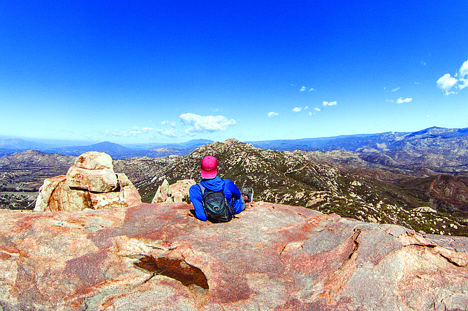
Me on the peak cropped looking at Gaskill Peak.
Lawson Peak
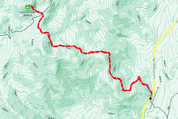
- Located east of Jamul, Lawson Peak is a moderate hike and flexible clothes are recommended. With a length of 4.3 miles and an elevation gain of 1500+ feet, the hike will take most people between 3 hours to reach the summit and descend.
- Distance from downtown San Diego: 32 miles • Hike length: 4.3 miles • Difficulty: Moderately strenuous • Season: November - May
I had spent an hour on the granite plateau eating lunch and taking photos of the rolling valleys and prominent peaks east of Jamul. It was a perfect day to enjoy a bit of solitude; and being mid-afternoon, the air was warm and clear with a dry breeze blowing from the west. I sat looking far away to the north at the southern face of Mount San Jacinto in Riverside County. A bit of haze was beginning to obscure my view, so I turned east where I saw that my seclusion was coming to an end as a pair of hikers walked along the trail below.
You can navigate to the trailhead by searching “Lawson Peak Trailhead” on Google Maps.
Given the lateness of the day, I was surprised to see others coming this way. Struck by curiosity, I set my camera on them like Jimmy Stewart in Rear Window and swapped my lens for a closer look. The two hikers were in their mid-twenties and resembled each other in look, stride, and gear. I guessed that they were brothers. Both wore a wide brim hat and cotton shirt, and one of them lugged a big military surplus backpack. It was a cumbersome load that seemed a bit too much for the trail, but I reasoned that he might be training for an upcoming trip. For the most part, I was just glad to see some hikers who didn’t look like yuppies who had stripped the clothes off an REI mannequin.
The brothers had just reached the top of the ridge after sidewinding nearly two miles up from the trailhead and gaining just under 1,300’ of elevation. I was another 300’ above them on an outcrop of granite slabs. From my vantage point I could see they were breathing hard and bent from their packs. Leaning on their trekking poles, they continued my direction along loose rocks while passing a large wall of granite. They had not yet noticed me, so I continued to spy on them from above. Soon their path began to dip and they arrived at a flat, sandy crossroad where the trail split four ways. They looked around uncertainly and bowed their heads together to consult their map. The right-hand path climbed up another mile and a half to Gaskill Peak. The path before them sloped up to Lawson Peak, where I was comfortably perched. And the left-hand path, well I don’t know where that would take them. As they weighed their options, I decided that a bit of company wouldn’t hurt, so I stood and waved until they caught sight of me. They seemed as surprised to see me as I was when I first saw them, and very quickly, they tucked their map away and began to walk up the steep slope below me. Soon after, they disappeared under a canopy of manzanita trees.
Lawson peak just before the sandy crossroad.
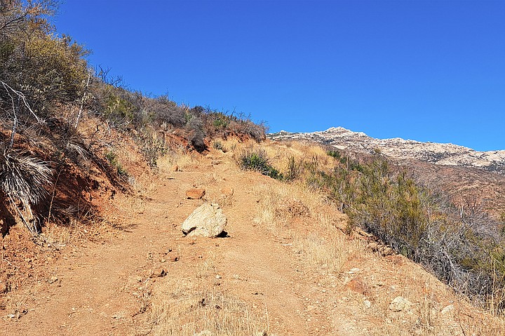
As I waited for them to reemerge, my eyes fell back along Lawson trail and I was surprised to see more unexpected company. Another pair of hikers were finishing the first section of the hike where the trail steadily winds up a series of long switchbacks. I suppose it’s inaccurate to call it a proper trail as it consists of a wide, two-pronged path that was likely designed for wheels not feet; though no truck could drive up this way as large stones and deep ruts hinder the path. From my standpoint, the trail looked as if it was carved by a mountain giant that dragged its stony finger across the hillside.
Peering through my viewfinder, the two hikers looked like a man and woman. They were young and fit and their climb upwards was unexpectedly swift. She wore a baseball cap, and he carried a backpack. Seeing as how my solitude was coming to an end, I decided to enjoy my remaining time on the peak and turned southwest to face the wind and look at the lonely Lyons Peak.
Twenty minutes passed before I began my descent. From the granite roof, I slid down into a circle of boulders where I ducked under brush and dropped into a narrow crack that fed into a cave. I crouched then climbed down and out of the rocky outcrop where I felt the earth under my boots again.
I had traced my steps back to the chaparral slope, when I heard voices. The two brothers were nowhere in sight and I was surprised to see the hiker couple coming up the hill. They asked me about the route to the peak, which can be hard to find, so I told them this:
“As you near the top, the path opens and veers left toward a cluster of boulders. Follow the path along the north face where you’ll find a lean trail between rock and brush. Follow this until it opens to a rocky wall. Don’t try to climb it, instead there’s a hidden path a few steps down away from the wall that veers northwest through more brush. Follow this path for a couple dozen paces until it bends back toward the granite slabs to an alcove below the trees. You’ll see a shoulder-wide slit in the rock that climbs up maybe fifteen feet. There’s a rope you can hold on to, but be careful. It’s hard to say how weathered and aged the rope is, so don’t put your faith in it.
“If you make it up, crouch through the cave until a passage opens above you like an escape hatch. Keep left until you come to a rock chute. To the right, you’ll find a path up. On the peak you’ll have a gorgeous 360-degree view. Nearby in the southwest stands Lyons Peak, with Sycuan and McGinty lying more due west. East you’ll see Corte Madera and Los Pinos. There’s a good view of Cuyamaca Mountain and on a clear day San Jacinto Peak, which looms over Idyllwild.”
Then they thanked me and we went our separate ways.
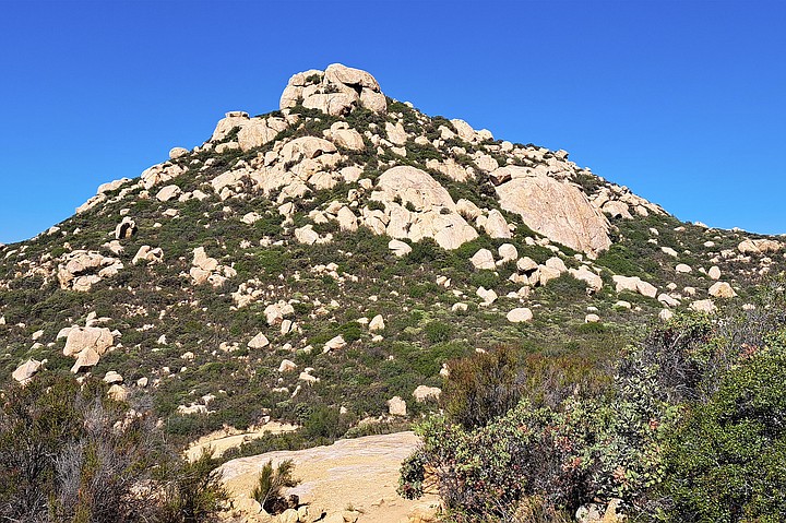
Lawson trail with Gaskill Peak in background.
I passed by the two brothers, who were on their way down. Either they didn’t find the route up or they didn’t want to risk it. I didn’t ask. My mind was busy trying to keep my feet so I wouldn’t slip and get swept into a bush.
Once I got off the slope, I continued through the sandy crossroad and passed the granite wall. Its face sparkled as it caught the shining sun. The long switchbacks were easy to follow as lizards and grasshoppers scurried underfoot. In the distance I heard the pop, pop, pop of gunfire from a nearby shooting range.
Every so often, I turned around to look for the couple standing on top of the peak. I was hoping to see that they had safely made it – and to snag a photo for this article. Over the course of a half hour, I turned around maybe ten times. Much to my dismay, I never saw their silhouettes on top of Lawson Peak.
You can navigate to the trailhead by searching “Lawson Peak Trailhead” on Google Maps. It will drop a pin on Lyons Valley Road a couple miles from Barrett Lake. Your only parking is a shoulder on the side of the road that can fit six cars and another shoulder further north down the road that can fit two cars. There’s no bathroom nearby, so plan accordingly. Bring at least a liter of water. If you plan on hiking up the final slope to Lawson Peak, dress in flexible clothes.
Here's something you might be interested in.
Two hikers on the ascent to Lawson Peak and two on the way down
I decided a bit of company wouldn’t hurt
Two hikers on the ascent to Lawson Peak and two on the way down
I decided a bit of company wouldn’t hurt
Me on the peak cropped looking at Gaskill Peak.
Lawson Peak
- Located east of Jamul, Lawson Peak is a moderate hike and flexible clothes are recommended. With a length of 4.3 miles and an elevation gain of 1500+ feet, the hike will take most people between 3 hours to reach the summit and descend.
- Distance from downtown San Diego: 32 miles • Hike length: 4.3 miles • Difficulty: Moderately strenuous • Season: November - May
I had spent an hour on the granite plateau eating lunch and taking photos of the rolling valleys and prominent peaks east of Jamul. It was a perfect day to enjoy a bit of solitude; and being mid-afternoon, the air was warm and clear with a dry breeze blowing from the west. I sat looking far away to the north at the southern face of Mount San Jacinto in Riverside County. A bit of haze was beginning to obscure my view, so I turned east where I saw that my seclusion was coming to an end as a pair of hikers walked along the trail below.
You can navigate to the trailhead by searching “Lawson Peak Trailhead” on Google Maps.
Given the lateness of the day, I was surprised to see others coming this way. Struck by curiosity, I set my camera on them like Jimmy Stewart in Rear Window and swapped my lens for a closer look. The two hikers were in their mid-twenties and resembled each other in look, stride, and gear. I guessed that they were brothers. Both wore a wide brim hat and cotton shirt, and one of them lugged a big military surplus backpack. It was a cumbersome load that seemed a bit too much for the trail, but I reasoned that he might be training for an upcoming trip. For the most part, I was just glad to see some hikers who didn’t look like yuppies who had stripped the clothes off an REI mannequin.
The brothers had just reached the top of the ridge after sidewinding nearly two miles up from the trailhead and gaining just under 1,300’ of elevation. I was another 300’ above them on an outcrop of granite slabs. From my vantage point I could see they were breathing hard and bent from their packs. Leaning on their trekking poles, they continued my direction along loose rocks while passing a large wall of granite. They had not yet noticed me, so I continued to spy on them from above. Soon their path began to dip and they arrived at a flat, sandy crossroad where the trail split four ways. They looked around uncertainly and bowed their heads together to consult their map. The right-hand path climbed up another mile and a half to Gaskill Peak. The path before them sloped up to Lawson Peak, where I was comfortably perched. And the left-hand path, well I don’t know where that would take them. As they weighed their options, I decided that a bit of company wouldn’t hurt, so I stood and waved until they caught sight of me. They seemed as surprised to see me as I was when I first saw them, and very quickly, they tucked their map away and began to walk up the steep slope below me. Soon after, they disappeared under a canopy of manzanita trees.
Lawson peak just before the sandy crossroad.
As I waited for them to reemerge, my eyes fell back along Lawson trail and I was surprised to see more unexpected company. Another pair of hikers were finishing the first section of the hike where the trail steadily winds up a series of long switchbacks. I suppose it’s inaccurate to call it a proper trail as it consists of a wide, two-pronged path that was likely designed for wheels not feet; though no truck could drive up this way as large stones and deep ruts hinder the path. From my standpoint, the trail looked as if it was carved by a mountain giant that dragged its stony finger across the hillside.
Peering through my viewfinder, the two hikers looked like a man and woman. They were young and fit and their climb upwards was unexpectedly swift. She wore a baseball cap, and he carried a backpack. Seeing as how my solitude was coming to an end, I decided to enjoy my remaining time on the peak and turned southwest to face the wind and look at the lonely Lyons Peak.
Twenty minutes passed before I began my descent. From the granite roof, I slid down into a circle of boulders where I ducked under brush and dropped into a narrow crack that fed into a cave. I crouched then climbed down and out of the rocky outcrop where I felt the earth under my boots again.
I had traced my steps back to the chaparral slope, when I heard voices. The two brothers were nowhere in sight and I was surprised to see the hiker couple coming up the hill. They asked me about the route to the peak, which can be hard to find, so I told them this:
“As you near the top, the path opens and veers left toward a cluster of boulders. Follow the path along the north face where you’ll find a lean trail between rock and brush. Follow this until it opens to a rocky wall. Don’t try to climb it, instead there’s a hidden path a few steps down away from the wall that veers northwest through more brush. Follow this path for a couple dozen paces until it bends back toward the granite slabs to an alcove below the trees. You’ll see a shoulder-wide slit in the rock that climbs up maybe fifteen feet. There’s a rope you can hold on to, but be careful. It’s hard to say how weathered and aged the rope is, so don’t put your faith in it.
“If you make it up, crouch through the cave until a passage opens above you like an escape hatch. Keep left until you come to a rock chute. To the right, you’ll find a path up. On the peak you’ll have a gorgeous 360-degree view. Nearby in the southwest stands Lyons Peak, with Sycuan and McGinty lying more due west. East you’ll see Corte Madera and Los Pinos. There’s a good view of Cuyamaca Mountain and on a clear day San Jacinto Peak, which looms over Idyllwild.”
Then they thanked me and we went our separate ways.
Lawson trail with Gaskill Peak in background.
I passed by the two brothers, who were on their way down. Either they didn’t find the route up or they didn’t want to risk it. I didn’t ask. My mind was busy trying to keep my feet so I wouldn’t slip and get swept into a bush.
Once I got off the slope, I continued through the sandy crossroad and passed the granite wall. Its face sparkled as it caught the shining sun. The long switchbacks were easy to follow as lizards and grasshoppers scurried underfoot. In the distance I heard the pop, pop, pop of gunfire from a nearby shooting range.
Every so often, I turned around to look for the couple standing on top of the peak. I was hoping to see that they had safely made it – and to snag a photo for this article. Over the course of a half hour, I turned around maybe ten times. Much to my dismay, I never saw their silhouettes on top of Lawson Peak.
You can navigate to the trailhead by searching “Lawson Peak Trailhead” on Google Maps. It will drop a pin on Lyons Valley Road a couple miles from Barrett Lake. Your only parking is a shoulder on the side of the road that can fit six cars and another shoulder further north down the road that can fit two cars. There’s no bathroom nearby, so plan accordingly. Bring at least a liter of water. If you plan on hiking up the final slope to Lawson Peak, dress in flexible clothes.
Comments