Here's something you might be interested in.
Ask a Hipster — Advice you didn't know you needed
Big Screen — Movie commentary
Blurt — Music's inside track
Booze News — San Diego spirits
Classical Music — Immortal beauty
Classifieds — Free and easy
Close to Home — What it’s like on the street where you live
Cover Stories — Front-page features
Drinks All Around — Bartenders' drink recipes
Excerpts — Literary and spiritual excerpts
Feast! — Food & drink reviews
Feature Stories — Local news & stories
Fishing Report — What’s getting hooked from ship and shore
From the Archives — Spotlight on the past
Golden Dreams — Talk of the town
The Gonzo Report — Making the musical scene, or at least reporting from it
Letters — Our inbox
Movies@Home — Local movie buffs share favorites
Movie Reviews — Our critics' picks and pans
Musician Interviews — Up close with local artists
Neighborhood News from Stringers — Hyperlocal news
News Ticker — News & politics
Obermeyer — San Diego politics illustrated
Outdoors — Weekly changes in flora and fauna
Overheard in San Diego — Eavesdropping illustrated
Poetry — The old and the new
Reader Travel — Travel section built by travelers
Reading — The hunt for intellectuals
Roam-O-Rama — SoCal's best hiking/biking trails
San Diego Beer — Inside San Diego suds
SD on the QT — Almost factual news
Sheep and Goats — Places of worship
Special Issues — The best of
Street Style — San Diego streets have style
Surf Diego — Real stories from those braving the waves
Theater — On stage in San Diego this week
Tin Fork — Silver spoon alternative
Under the Radar — Matt Potter's undercover work
Unforgettable — Long-ago San Diego
Unreal Estate — San Diego's priciest pads
Your Week — Daily event picks
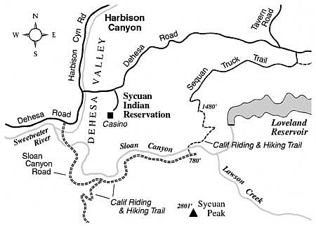
Explore a scenic stretch of the California Riding and Hiking Trail near Alpine.
The California Riding and Hiking Trail, a designated, regional multi-use (hiking/biking/equestrian) trail that strikes a southwest-to-northeast course through the middle of San Diego County, is still a work in progress. Most of the trail is open for public use, but some sections have access problems where the trail crosses private property. The southern half of the trail wends its way through the Jamul, Alpine, and Descanso areas, and eventually passes into Cuyamaca Rancho State Park.
The particularly pleasant stretch of the California Riding and Hiking Trail described here is open to the public. It will take you two miles downhill, with a loss of 900 feet of elevation, into beautiful Sloan Canyon, where a riparian strip of vegetation accompanies the winding Sweetwater River. Try this hike (or ride) early on a chilly winter morning, when beams of light from the rising sun scatter amid dew droplets or ice crystals clinging to the tips of the chaparral vegetation.
To reach the starting point, exit Interstate 8 at Tavern Road in Alpine, and follow Tavern Road 2.7 miles south to Dehesa Road on the right and Japatul Road straight ahead. Continue 0.3 mile east on Japatul Road, and turn right on Sequan Truck Trail (a paved road). After 2.8 miles, the pavement ends. Continue 0.2 mile to a sharp right bend in the road and park where you can find the space to do so.
Walk south on Sequan Truck Trail for 0.25 mile past some houses, then follow the signed California Riding and Hiking Trail as it diverges to the left and descends sharply along a south-facing slope. Sloan Canyon lies below, and beyond it you'll see the broad, north slope of Sycuan Peak (pronounced "Sequan") rearing into the sky above. Uncut by roads, the north flank of the mountain wears its thick chaparral naturally, like a shaggy variegated carpet. Other high points in the field of view are the rocky summits of Lyons, Lawson, and Gaskill peaks to the southeast.
After 1.3 miles, the trail joins a spur road. A messy collection of rural houses lies to the left, down below in Sloan Canyon. You go right and pass above an intriguing (but privately owned) little gorge where the Sweetwater River has cut its way through exfoliated granite slabs. At 2.0 miles you reach the river itself, and beyond that there's a vehicle gate alongside Sloan Canyon Road. The oak- and willow-shaded riverbank area is great for watching birds and other wildlife. Rest up before you reverse your steps back up the slope to the starting point.
This article contains information about a publicly owned recreation or wilderness area. Trails and pathways are not necessarily marked. Conditions can change rapidly. Hikers should be properly equipped and have safety and navigational skills. The Reader and Jerry Schad assume no responsibility for any adverse experience.
Here's something you might be interested in.
Explore a scenic stretch of the California Riding and Hiking Trail near Alpine.
Explore a scenic stretch of the California Riding and Hiking Trail near Alpine.
The California Riding and Hiking Trail, a designated, regional multi-use (hiking/biking/equestrian) trail that strikes a southwest-to-northeast course through the middle of San Diego County, is still a work in progress. Most of the trail is open for public use, but some sections have access problems where the trail crosses private property. The southern half of the trail wends its way through the Jamul, Alpine, and Descanso areas, and eventually passes into Cuyamaca Rancho State Park.
The particularly pleasant stretch of the California Riding and Hiking Trail described here is open to the public. It will take you two miles downhill, with a loss of 900 feet of elevation, into beautiful Sloan Canyon, where a riparian strip of vegetation accompanies the winding Sweetwater River. Try this hike (or ride) early on a chilly winter morning, when beams of light from the rising sun scatter amid dew droplets or ice crystals clinging to the tips of the chaparral vegetation.
To reach the starting point, exit Interstate 8 at Tavern Road in Alpine, and follow Tavern Road 2.7 miles south to Dehesa Road on the right and Japatul Road straight ahead. Continue 0.3 mile east on Japatul Road, and turn right on Sequan Truck Trail (a paved road). After 2.8 miles, the pavement ends. Continue 0.2 mile to a sharp right bend in the road and park where you can find the space to do so.
Walk south on Sequan Truck Trail for 0.25 mile past some houses, then follow the signed California Riding and Hiking Trail as it diverges to the left and descends sharply along a south-facing slope. Sloan Canyon lies below, and beyond it you'll see the broad, north slope of Sycuan Peak (pronounced "Sequan") rearing into the sky above. Uncut by roads, the north flank of the mountain wears its thick chaparral naturally, like a shaggy variegated carpet. Other high points in the field of view are the rocky summits of Lyons, Lawson, and Gaskill peaks to the southeast.
After 1.3 miles, the trail joins a spur road. A messy collection of rural houses lies to the left, down below in Sloan Canyon. You go right and pass above an intriguing (but privately owned) little gorge where the Sweetwater River has cut its way through exfoliated granite slabs. At 2.0 miles you reach the river itself, and beyond that there's a vehicle gate alongside Sloan Canyon Road. The oak- and willow-shaded riverbank area is great for watching birds and other wildlife. Rest up before you reverse your steps back up the slope to the starting point.
This article contains information about a publicly owned recreation or wilderness area. Trails and pathways are not necessarily marked. Conditions can change rapidly. Hikers should be properly equipped and have safety and navigational skills. The Reader and Jerry Schad assume no responsibility for any adverse experience.