Here's something you might be interested in.
Ask a Hipster — Advice you didn't know you needed
Big Screen — Movie commentary
Blurt — Music's inside track
Booze News — San Diego spirits
Classical Music — Immortal beauty
Classifieds — Free and easy
Close to Home — What it’s like on the street where you live
Cover Stories — Front-page features
Drinks All Around — Bartenders' drink recipes
Excerpts — Literary and spiritual excerpts
Feast! — Food & drink reviews
Feature Stories — Local news & stories
Fishing Report — What’s getting hooked from ship and shore
From the Archives — Spotlight on the past
Golden Dreams — Talk of the town
The Gonzo Report — Making the musical scene, or at least reporting from it
Letters — Our inbox
Movies@Home — Local movie buffs share favorites
Movie Reviews — Our critics' picks and pans
Musician Interviews — Up close with local artists
Neighborhood News from Stringers — Hyperlocal news
News Ticker — News & politics
Obermeyer — San Diego politics illustrated
Outdoors — Weekly changes in flora and fauna
Overheard in San Diego — Eavesdropping illustrated
Poetry — The old and the new
Reader Travel — Travel section built by travelers
Reading — The hunt for intellectuals
Roam-O-Rama — SoCal's best hiking/biking trails
San Diego Beer — Inside San Diego suds
SD on the QT — Almost factual news
Sheep and Goats — Places of worship
Special Issues — The best of
Street Style — San Diego streets have style
Surf Diego — Real stories from those braving the waves
Theater — On stage in San Diego this week
Tin Fork — Silver spoon alternative
Under the Radar — Matt Potter's undercover work
Unforgettable — Long-ago San Diego
Unreal Estate — San Diego's priciest pads
Your Week — Daily event picks
At the Loveland Dam, on the Sweetwater River
Shorebirds and chaparral abound at Alpine’s manmade lake.
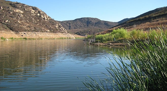
This lake view is from the opposite side of the marsh area.

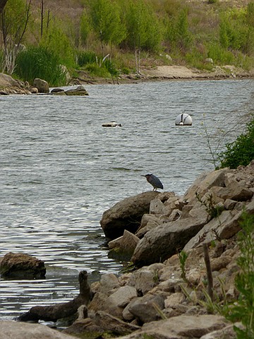
Redwing blackbird on the shore
Loveland Dam, also known as Sweetwater Falls Dam, is a thin arch design of concrete built in 1945. Loveland Reservoir is one of the two manmade lakes made by dams along the Sweetwater River. It has a capacity of 25,387 acre feet of water and is used for flood control and drinking water for Chula Vista, National City, and Bonita residents. Loveland is the younger of the two dams. Until 1966 the reservoir was used solely for water storage. A land exchange between the Sweetwater Authority and the U.S. Forest Service gave the authority control over land adjacent to the reservoir. The authority constructed a parking lot and trail and opened the reservoir to the public for fishing on January 14, 1997. It is open only to shoreline fishing — no boats, swimming, or use of live bait is allowed. Largemouth bass, channel and bullhead catfish, bluegill, red-eared sunfish, and crappie can all be caught at Loveland, with the proper fishing license and in the posted fishing areas only. Trails offer little to no shade, so it is best to hike in the early mornings before the heat of the day sets in.
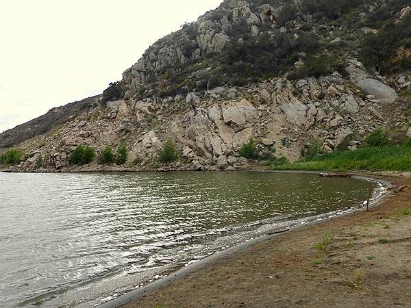
Loveland shoreline
The trail starts at the parking-lot trailhead and quickly descends to the reservoir by way of a flight of wooden steps. Drought conditions have greatly reduced the size of this reservoir. Depending on the current water level, which fluctuates throughout the year, the easternmost, shallow arm can turn into a soggy meadow that is difficult to traverse. Trails are found to the left and right along the lakeshore but aren’t always obvious and may be difficult to follow. Trails are also found at different levels, as the water has fluctuated and can be uneven, rocky, and brush-covered.
Kingfisher on a rock
The trails to the east or left can be explored for a short distance but are not recommended with low-water conditions that have left most of the area dry or with patches of marshy areas thick with riparian growth such as cattails and willows. If exploring this area, look down and note the many clam shells scattered about, left high and dry as the water has receded.
The trail to the west or right from the staircase and bridge leads down to the metal fishing pier that is totally surrounded by cattails and other thick vegetation. Red-winged blackbirds flit around the cattails. A fisherman’s trail leads through a thicket of plants, past the pier, to the shoreline of the reservoir where waterfowl such as belted kingfishers, herons, and pelicans may be seen. Also look for migratory birds that may be in the area.
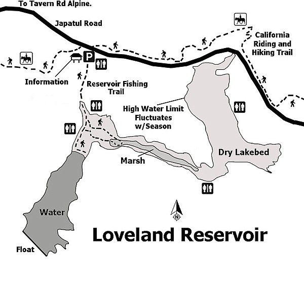
Loveland Reservoir hiking trails
The chaparral terrain above the lake is dominated by chamise, a native chaparral plant that has tiny, cream-colored flowers that extend from the ends of stems in cone shapes and blooms in spring and early summer. Also found is California buckwheat, scrub oaks, coast live oaks, laurel sumacs, broom baccharis, black sage, and other common chaparral and oak woodland plants. Keep an eye out for any lizards or birds that can be seen along the trail.
For those who might want to explore more in this area, a portion of the California Riding & Hiking Trail (CR&HT) is accessible from the west side of the parking area. About 12 miles of the CR&HT, established statewide in 1945, winds through Alpine between Crest and Dehesa.
Distance from downtown San Diego: About 34 miles. Allow 40 minutes driving time (Alpine). From I-8, exit south on Tavern Rd, which becomes Japatul Rd. after passing Dehesa Rd. In about 0.75 mile after passing Sycuan Truck Trail is the parking area on the south side of the road.
Hiking length: 1–2 miles, with optional miles available along the California Riding & Hiking Trail. Allow 1–2 hours.
Difficulty: Easy to moderate, depending on water level and shoreline. Elevation gain/loss 100 feet. Steps lead down toward the water. No dogs allowed. Porta-potties and trash cans but no potable water. Open sunrise to sunset daily except for major holidays, when it is closed. Vehicle towed away if left in the lot after closing.
Here's something you might be interested in.
At the Loveland Dam, on the Sweetwater River
Shorebirds and chaparral abound at Alpine’s manmade lake.
At the Loveland Dam, on the Sweetwater River
Shorebirds and chaparral abound at Alpine’s manmade lake.
This lake view is from the opposite side of the marsh area.
Redwing blackbird on the shore
Loveland Dam, also known as Sweetwater Falls Dam, is a thin arch design of concrete built in 1945. Loveland Reservoir is one of the two manmade lakes made by dams along the Sweetwater River. It has a capacity of 25,387 acre feet of water and is used for flood control and drinking water for Chula Vista, National City, and Bonita residents. Loveland is the younger of the two dams. Until 1966 the reservoir was used solely for water storage. A land exchange between the Sweetwater Authority and the U.S. Forest Service gave the authority control over land adjacent to the reservoir. The authority constructed a parking lot and trail and opened the reservoir to the public for fishing on January 14, 1997. It is open only to shoreline fishing — no boats, swimming, or use of live bait is allowed. Largemouth bass, channel and bullhead catfish, bluegill, red-eared sunfish, and crappie can all be caught at Loveland, with the proper fishing license and in the posted fishing areas only. Trails offer little to no shade, so it is best to hike in the early mornings before the heat of the day sets in.
Loveland shoreline
The trail starts at the parking-lot trailhead and quickly descends to the reservoir by way of a flight of wooden steps. Drought conditions have greatly reduced the size of this reservoir. Depending on the current water level, which fluctuates throughout the year, the easternmost, shallow arm can turn into a soggy meadow that is difficult to traverse. Trails are found to the left and right along the lakeshore but aren’t always obvious and may be difficult to follow. Trails are also found at different levels, as the water has fluctuated and can be uneven, rocky, and brush-covered.
Kingfisher on a rock
The trails to the east or left can be explored for a short distance but are not recommended with low-water conditions that have left most of the area dry or with patches of marshy areas thick with riparian growth such as cattails and willows. If exploring this area, look down and note the many clam shells scattered about, left high and dry as the water has receded.
The trail to the west or right from the staircase and bridge leads down to the metal fishing pier that is totally surrounded by cattails and other thick vegetation. Red-winged blackbirds flit around the cattails. A fisherman’s trail leads through a thicket of plants, past the pier, to the shoreline of the reservoir where waterfowl such as belted kingfishers, herons, and pelicans may be seen. Also look for migratory birds that may be in the area.
Loveland Reservoir hiking trails
The chaparral terrain above the lake is dominated by chamise, a native chaparral plant that has tiny, cream-colored flowers that extend from the ends of stems in cone shapes and blooms in spring and early summer. Also found is California buckwheat, scrub oaks, coast live oaks, laurel sumacs, broom baccharis, black sage, and other common chaparral and oak woodland plants. Keep an eye out for any lizards or birds that can be seen along the trail.
For those who might want to explore more in this area, a portion of the California Riding & Hiking Trail (CR&HT) is accessible from the west side of the parking area. About 12 miles of the CR&HT, established statewide in 1945, winds through Alpine between Crest and Dehesa.
Distance from downtown San Diego: About 34 miles. Allow 40 minutes driving time (Alpine). From I-8, exit south on Tavern Rd, which becomes Japatul Rd. after passing Dehesa Rd. In about 0.75 mile after passing Sycuan Truck Trail is the parking area on the south side of the road.
Hiking length: 1–2 miles, with optional miles available along the California Riding & Hiking Trail. Allow 1–2 hours.
Difficulty: Easy to moderate, depending on water level and shoreline. Elevation gain/loss 100 feet. Steps lead down toward the water. No dogs allowed. Porta-potties and trash cans but no potable water. Open sunrise to sunset daily except for major holidays, when it is closed. Vehicle towed away if left in the lot after closing.