Here's something you might be interested in.
Ask a Hipster — Advice you didn't know you needed
Big Screen — Movie commentary
Blurt — Music's inside track
Booze News — San Diego spirits
Classical Music — Immortal beauty
Classifieds — Free and easy
Close to Home — What it’s like on the street where you live
Cover Stories — Front-page features
Drinks All Around — Bartenders' drink recipes
Excerpts — Literary and spiritual excerpts
Feast! — Food & drink reviews
Feature Stories — Local news & stories
Fishing Report — What’s getting hooked from ship and shore
From the Archives — Spotlight on the past
Golden Dreams — Talk of the town
The Gonzo Report — Making the musical scene, or at least reporting from it
Letters — Our inbox
Movies@Home — Local movie buffs share favorites
Movie Reviews — Our critics' picks and pans
Musician Interviews — Up close with local artists
Neighborhood News from Stringers — Hyperlocal news
News Ticker — News & politics
Obermeyer — San Diego politics illustrated
Outdoors — Weekly changes in flora and fauna
Overheard in San Diego — Eavesdropping illustrated
Poetry — The old and the new
Reader Travel — Travel section built by travelers
Reading — The hunt for intellectuals
Roam-O-Rama — SoCal's best hiking/biking trails
San Diego Beer — Inside San Diego suds
SD on the QT — Almost factual news
Sheep and Goats — Places of worship
Special Issues — The best of
Street Style — San Diego streets have style
Surf Diego — Real stories from those braving the waves
Theater — On stage in San Diego this week
Tin Fork — Silver spoon alternative
Under the Radar — Matt Potter's undercover work
Unforgettable — Long-ago San Diego
Unreal Estate — San Diego's priciest pads
Your Week — Daily event picks
Enjoy the urban landscape of Canyon Hills Open Space Loop
This lovely hike is hidden in plain sight.
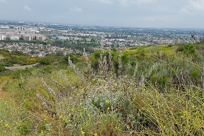
An open space in an urban sea
Canyon Hills Open Space is a surprise and a contrast to the noise from nearby I-15, which is quite close indeed. This open-space area is a reminder why it is so important to continue to preserve open space islands in the urban sea. It provides a place for many of the key plant species in the coastal sage scrub habitat to thrive, and many bloom in spectacular fashion. With no proper trees to compete for space, the laurel sumacs have grown to the stature of trees in some places, and the lemonadeberry bushes add a lovely green to the mix.
Start the hike heading south up the hill along the hillsides covered in black sage (Salvia mellifera) sporting pale blue or lavender flowers, interspersed with red and orange monkey flowers (Diplacus spp.) and golden (Eriophyllum sp.) and white (Achillea millefolium) yarrow. You may smell species within the genus Pseudognaphalium in the sunflower family that are commonly known as cudweeds, rabbit-tobacco, or everlasting. Pseudognaphalium californicum’s characteristic smell is that of maple syrup. Take in this lovely scent along with the aromas of the sages and sumacs that dominate the area.
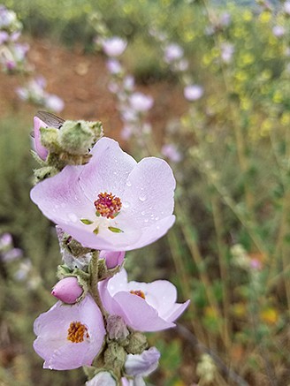
Look for chaparral bushmallow in coastal sage scrub
Keep left at the first fork (there is a picnic table on the right) and continue up the hill. White sage (Salvia apiana) is more evident here. This native sage has a pungent smell that can mask human odors. It was used by Native Americans to allow them to approach animals they were hunting without being detected by smell. California sagebrush (Artemisia californica) also grows in the coastal sage scrub plant community, and is sometimes called “cowboy cologne.”
The road takes you past a few towers and then heads downhill. Keep to the right and continue to a little loop at the bottom near several homes. This is an area surprisingly rich in bird life. You may see a red-tailed hawk perched on a snag, and ravens, doves, and hummingbirds in flight. If you’re lucky, you may see gnatcatchers feasting among the non-native mustard.
Head back up the hill and keep going straight to where the trail is intersected by another road that heads downhill and does not loop back. Instead, at the bottom of the hill that leads back up to the towers, take the left fork. This puts you on the lower road, providing a view of Los Peñasquitos Canyon carving its way to the west. All along the trail, there are lovely views: west and south to the coast, east and north to the mountains, and all around to a busy and vibrant San Diego.
This trail offers a chance to get away from the masses of people hiking the hot spots such as Mount Woodson, Cowles Mountain, Torrey Pines, and Iron Mountain. So even though it’s close to the freeway, it’s easy to feel a bit of escape and enjoy nature in this urban landscape.
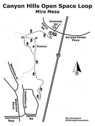
Canyon Hills map
CANYON HILLS OPEN SPACE LOOP (MIRA MESA)
This lovely hike is hidden in plain sight.
Driving directions: From I-15, exit at Scripps Poway Parkway/Mercy Road (Exit 17). Go west on Mercy Road, then turn south onto Alemania Road (actually more of a driveway), then take an immediate left into the six-spot parking lot. There is a Chevron Service Station across the street and more parking on Alemania Road north of Mercy Road. Hiking length: 2.4 miles. Difficulty: Easy to moderate. Elevation gain/loss is 570 feet. The trail is an access/fire road and the footing is quite good. It is used by hikers, runners, and dogs being walked on leashes. No facilities and no shade along the trail.
Here's something you might be interested in.
Enjoy the urban landscape of Canyon Hills Open Space Loop
This lovely hike is hidden in plain sight.
Enjoy the urban landscape of Canyon Hills Open Space Loop
This lovely hike is hidden in plain sight.
An open space in an urban sea
Canyon Hills Open Space is a surprise and a contrast to the noise from nearby I-15, which is quite close indeed. This open-space area is a reminder why it is so important to continue to preserve open space islands in the urban sea. It provides a place for many of the key plant species in the coastal sage scrub habitat to thrive, and many bloom in spectacular fashion. With no proper trees to compete for space, the laurel sumacs have grown to the stature of trees in some places, and the lemonadeberry bushes add a lovely green to the mix.
Start the hike heading south up the hill along the hillsides covered in black sage (Salvia mellifera) sporting pale blue or lavender flowers, interspersed with red and orange monkey flowers (Diplacus spp.) and golden (Eriophyllum sp.) and white (Achillea millefolium) yarrow. You may smell species within the genus Pseudognaphalium in the sunflower family that are commonly known as cudweeds, rabbit-tobacco, or everlasting. Pseudognaphalium californicum’s characteristic smell is that of maple syrup. Take in this lovely scent along with the aromas of the sages and sumacs that dominate the area.
Look for chaparral bushmallow in coastal sage scrub
Keep left at the first fork (there is a picnic table on the right) and continue up the hill. White sage (Salvia apiana) is more evident here. This native sage has a pungent smell that can mask human odors. It was used by Native Americans to allow them to approach animals they were hunting without being detected by smell. California sagebrush (Artemisia californica) also grows in the coastal sage scrub plant community, and is sometimes called “cowboy cologne.”
The road takes you past a few towers and then heads downhill. Keep to the right and continue to a little loop at the bottom near several homes. This is an area surprisingly rich in bird life. You may see a red-tailed hawk perched on a snag, and ravens, doves, and hummingbirds in flight. If you’re lucky, you may see gnatcatchers feasting among the non-native mustard.
Head back up the hill and keep going straight to where the trail is intersected by another road that heads downhill and does not loop back. Instead, at the bottom of the hill that leads back up to the towers, take the left fork. This puts you on the lower road, providing a view of Los Peñasquitos Canyon carving its way to the west. All along the trail, there are lovely views: west and south to the coast, east and north to the mountains, and all around to a busy and vibrant San Diego.
This trail offers a chance to get away from the masses of people hiking the hot spots such as Mount Woodson, Cowles Mountain, Torrey Pines, and Iron Mountain. So even though it’s close to the freeway, it’s easy to feel a bit of escape and enjoy nature in this urban landscape.
Canyon Hills map
CANYON HILLS OPEN SPACE LOOP (MIRA MESA)
This lovely hike is hidden in plain sight.
Driving directions: From I-15, exit at Scripps Poway Parkway/Mercy Road (Exit 17). Go west on Mercy Road, then turn south onto Alemania Road (actually more of a driveway), then take an immediate left into the six-spot parking lot. There is a Chevron Service Station across the street and more parking on Alemania Road north of Mercy Road. Hiking length: 2.4 miles. Difficulty: Easy to moderate. Elevation gain/loss is 570 feet. The trail is an access/fire road and the footing is quite good. It is used by hikers, runners, and dogs being walked on leashes. No facilities and no shade along the trail.
Comments