Here's something you might be interested in.
Ask a Hipster — Advice you didn't know you needed
Big Screen — Movie commentary
Blurt — Music's inside track
Booze News — San Diego spirits
Classical Music — Immortal beauty
Classifieds — Free and easy
Close to Home — What it’s like on the street where you live
Cover Stories — Front-page features
Drinks All Around — Bartenders' drink recipes
Excerpts — Literary and spiritual excerpts
Feast! — Food & drink reviews
Feature Stories — Local news & stories
Fishing Report — What’s getting hooked from ship and shore
From the Archives — Spotlight on the past
Golden Dreams — Talk of the town
The Gonzo Report — Making the musical scene, or at least reporting from it
Letters — Our inbox
Movies@Home — Local movie buffs share favorites
Movie Reviews — Our critics' picks and pans
Musician Interviews — Up close with local artists
Neighborhood News from Stringers — Hyperlocal news
News Ticker — News & politics
Obermeyer — San Diego politics illustrated
Outdoors — Weekly changes in flora and fauna
Overheard in San Diego — Eavesdropping illustrated
Poetry — The old and the new
Reader Travel — Travel section built by travelers
Reading — The hunt for intellectuals
Roam-O-Rama — SoCal's best hiking/biking trails
San Diego Beer — Inside San Diego suds
SD on the QT — Almost factual news
Sheep and Goats — Places of worship
Special Issues — The best of
Street Style — San Diego streets have style
Surf Diego — Real stories from those braving the waves
Theater — On stage in San Diego this week
Tin Fork — Silver spoon alternative
Under the Radar — Matt Potter's undercover work
Unforgettable — Long-ago San Diego
Unreal Estate — San Diego's priciest pads
Your Week — Daily event picks
Urban canyoneering
The lush low places of City Heights
One of the surprising delights of this trail
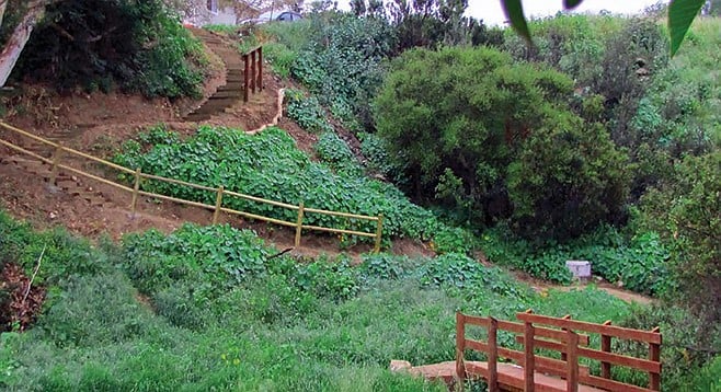
Olivia Canyon. also known as 47th Street Canyon, is the eastern-most canyon of the City Heights Canyons Loop Trail system. There are five trailheads into this canyon. Near the entry at 47th Street, you will find interpretive signage highlighting some of the flora and fauna found in our urban canyons. Follow the trail down to the canyon bottom and, before you cross the bridge, take a left. In the creek bed on your right, notice the towering Hooker’s evening primrose (Oenothera elata). This whole canyon used to be filled with the invasive Arundo donax before dedicated volunteers and organizations, including the Friends of Olivia Canyon and San Diego Canyonlands, spent years eradicating the plant and restoring the canyon back to its native habitat. Once the arundo was removed, the primrose sprouted up from a dormant seedbank and has populated this area of the canyon ever since.
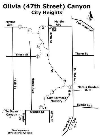
Olivia (47th Street) Canyon map
Follow the trail through a stand of tall arroyo willow trees (Salix lasiolepis) and up a short slope through a patch of non-native prickly pear cactus loaded with cochineal, a white, waxy-looking scale insect that is used in red dye. This parasite lives on cactus in the genus Opuntia and feeds on nutrients and moisture from the plant. Carminic acid is extracted from the insect to produce shades of scarlet and crimson. The dye carmine is used in artificial crab meat, fruit drinks, candy, ice cream, and chewing gum.
The path levels out here and you can find toyon (Heteromeles arbutifolia), lemonadeberry (Rhus integrifolia), wild cucumber (Marah macrocarpa) and stands of eucalyptus trees. Farther down, the path intersects with the creek bed and here you can find elderberry (Sambucus nigra), California sagebrush (Artemisia californica), and loads of yerba santa (Eriodictyon crassifolium). You may also see a bladderpod (Peritoma arborea) plant if you keep an eye out for it on your left-hand side.
The trail intersects with Euclid Avenue, and to continue the hike, take a right. If you’re in the mood for a tasty meal or beverage, stop by Nate’s Garden Grill for a break. You can also stop by City Farmers Nursery to pick up a plant or visit with the animals there. Both establishments are adjacent to the trails and the Euclid Avenue trailhead.
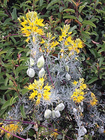
Bladderpod is found on the trail
Continuing on the hike, you will pass by a group of California sunflower (Encelia californica) bushes. If you look past the sunflowers and into the basin, you will see the results of the years-long restoration project that is successfully restoring the native habitat. Follow the trail up the newly constructed switchbacks and on to the mesa. Here look for California everlasting (Pseudognaphalium californicum) and black sage (Salvia mellifera) sprouting up from seeds, which you might smell before you actually see them. Both of these plants are very aromatic. The sticky bright green leaves of California everlasting smell like maple syrup and are distinct from the strong smell of the black sage.
As the path winds down with more switchbacks, look to your left and try to catch a glimpse of the City Farmers cow—one of the many animals found at this working farm and nursery. Continue through a large patch of acacia and up the hill. About mid-way up the hill, there is a nice shady spot with a view of Mt. San Miguel. At the top of the hill is Quince Street, which is the turn-around point. If you would like to make the hike longer, you can continue on to the other canyons in the City Heights Loop Trail system, but be sure to take a map for that.
The best time of year to visit the trail is in spring when the native plants are in bloom. However, this hike offers a good amount of shade, so it is also suitable for the warmer months.
Driving directions: From I-805, take the Home Avenue exit and go northeast. Continue 1.1 miles on Home Avenue where it turns into Euclid Avenue, then go 0.3 mile and turn left on to Myrtle Avenue, which will come to a T with 47th Street. The trailhead is just beyond the empty lot at the intersection of 47th Street and Myrtle Avenue. Street parking in residential area, no facilities.
Hiking length: 1.5 miles out and back. Options to link to other canyon trails in the City Heights Canyons Loop Trail system, plus the Chollas Creek Oak Park Branch trail system. Allow 30 minutes to 1 hour hiking time.
Difficulty: Easy. A few spots with some elevation gain/loss, but mostly the trail is level and wide. Appropriate for children.
Here's something you might be interested in.
Urban canyoneering
The lush low places of City Heights
Urban canyoneering
The lush low places of City Heights
One of the surprising delights of this trail
Olivia Canyon. also known as 47th Street Canyon, is the eastern-most canyon of the City Heights Canyons Loop Trail system. There are five trailheads into this canyon. Near the entry at 47th Street, you will find interpretive signage highlighting some of the flora and fauna found in our urban canyons. Follow the trail down to the canyon bottom and, before you cross the bridge, take a left. In the creek bed on your right, notice the towering Hooker’s evening primrose (Oenothera elata). This whole canyon used to be filled with the invasive Arundo donax before dedicated volunteers and organizations, including the Friends of Olivia Canyon and San Diego Canyonlands, spent years eradicating the plant and restoring the canyon back to its native habitat. Once the arundo was removed, the primrose sprouted up from a dormant seedbank and has populated this area of the canyon ever since.
Olivia (47th Street) Canyon map
Follow the trail through a stand of tall arroyo willow trees (Salix lasiolepis) and up a short slope through a patch of non-native prickly pear cactus loaded with cochineal, a white, waxy-looking scale insect that is used in red dye. This parasite lives on cactus in the genus Opuntia and feeds on nutrients and moisture from the plant. Carminic acid is extracted from the insect to produce shades of scarlet and crimson. The dye carmine is used in artificial crab meat, fruit drinks, candy, ice cream, and chewing gum.
The path levels out here and you can find toyon (Heteromeles arbutifolia), lemonadeberry (Rhus integrifolia), wild cucumber (Marah macrocarpa) and stands of eucalyptus trees. Farther down, the path intersects with the creek bed and here you can find elderberry (Sambucus nigra), California sagebrush (Artemisia californica), and loads of yerba santa (Eriodictyon crassifolium). You may also see a bladderpod (Peritoma arborea) plant if you keep an eye out for it on your left-hand side.
The trail intersects with Euclid Avenue, and to continue the hike, take a right. If you’re in the mood for a tasty meal or beverage, stop by Nate’s Garden Grill for a break. You can also stop by City Farmers Nursery to pick up a plant or visit with the animals there. Both establishments are adjacent to the trails and the Euclid Avenue trailhead.
Bladderpod is found on the trail
Continuing on the hike, you will pass by a group of California sunflower (Encelia californica) bushes. If you look past the sunflowers and into the basin, you will see the results of the years-long restoration project that is successfully restoring the native habitat. Follow the trail up the newly constructed switchbacks and on to the mesa. Here look for California everlasting (Pseudognaphalium californicum) and black sage (Salvia mellifera) sprouting up from seeds, which you might smell before you actually see them. Both of these plants are very aromatic. The sticky bright green leaves of California everlasting smell like maple syrup and are distinct from the strong smell of the black sage.
As the path winds down with more switchbacks, look to your left and try to catch a glimpse of the City Farmers cow—one of the many animals found at this working farm and nursery. Continue through a large patch of acacia and up the hill. About mid-way up the hill, there is a nice shady spot with a view of Mt. San Miguel. At the top of the hill is Quince Street, which is the turn-around point. If you would like to make the hike longer, you can continue on to the other canyons in the City Heights Loop Trail system, but be sure to take a map for that.
The best time of year to visit the trail is in spring when the native plants are in bloom. However, this hike offers a good amount of shade, so it is also suitable for the warmer months.
Driving directions: From I-805, take the Home Avenue exit and go northeast. Continue 1.1 miles on Home Avenue where it turns into Euclid Avenue, then go 0.3 mile and turn left on to Myrtle Avenue, which will come to a T with 47th Street. The trailhead is just beyond the empty lot at the intersection of 47th Street and Myrtle Avenue. Street parking in residential area, no facilities.
Hiking length: 1.5 miles out and back. Options to link to other canyon trails in the City Heights Canyons Loop Trail system, plus the Chollas Creek Oak Park Branch trail system. Allow 30 minutes to 1 hour hiking time.
Difficulty: Easy. A few spots with some elevation gain/loss, but mostly the trail is level and wide. Appropriate for children.
Comments