Here's something you might be interested in.
Ask a Hipster — Advice you didn't know you needed
Big Screen — Movie commentary
Blurt — Music's inside track
Booze News — San Diego spirits
Classical Music — Immortal beauty
Classifieds — Free and easy
Close to Home — What it’s like on the street where you live
Cover Stories — Front-page features
Drinks All Around — Bartenders' drink recipes
Excerpts — Literary and spiritual excerpts
Feast! — Food & drink reviews
Feature Stories — Local news & stories
Fishing Report — What’s getting hooked from ship and shore
From the Archives — Spotlight on the past
Golden Dreams — Talk of the town
The Gonzo Report — Making the musical scene, or at least reporting from it
Letters — Our inbox
Movies@Home — Local movie buffs share favorites
Movie Reviews — Our critics' picks and pans
Musician Interviews — Up close with local artists
Neighborhood News from Stringers — Hyperlocal news
News Ticker — News & politics
Obermeyer — San Diego politics illustrated
Outdoors — Weekly changes in flora and fauna
Overheard in San Diego — Eavesdropping illustrated
Poetry — The old and the new
Reader Travel — Travel section built by travelers
Reading — The hunt for intellectuals
Roam-O-Rama — SoCal's best hiking/biking trails
San Diego Beer — Inside San Diego suds
SD on the QT — Almost factual news
Sheep and Goats — Places of worship
Special Issues — The best of
Street Style — San Diego streets have style
Surf Diego — Real stories from those braving the waves
Theater — On stage in San Diego this week
Tin Fork — Silver spoon alternative
Under the Radar — Matt Potter's undercover work
Unforgettable — Long-ago San Diego
Unreal Estate — San Diego's priciest pads
Your Week — Daily event picks
The Painted Gorge: from under the sea to desert region
Ancient seas and minor impurities in granitic and volcanic rocks give rise to the vivid colors
Ancient seas and minor impurities give rise to the vivid colors.
The Painted Gorge near Ocotillo and Plaster City offers the opportunity to explore the brightly colored mud hills of an ancient marine layer and volcanic flows. This particular excursion is of variable length and difficulty, ranging from a quick side trip (less than 1 hour) to a serious hike, so be sure to plan ahead.
The hills, formations, and drainage are soft but distinct pastel colors. Ancient seas and minor impurities in granitic and volcanic rocks give rise to the vivid colors. As in most “painted” regions of the world, the leading source of color is iron. In its oxidized state, as in exposed to the air, it rusts. Iron traces in geological formations then create a red-tone. When iron “reduces” or is in a low oxygen environment, like underwater in an ancient sea, it can turn a geological formation green. In the Painted Gorge, the colors can tell you something about the underlying geology. Here, the main Imperial Formation is a marine layer, and mostly a soft yellow color from the sulfur-oxides in the soil. The brilliant blues are from the Alverson volcanic layer that also carries the colorful irons.
The Painted Gorge area is a place of contradictions. Now a desert, 450 million years ago this part of North America was under the sea. The area does not lend itself to conventional agriculture. Viewed by some as a wasteland, from 1942-1959 the area just to the north, the Carrizo Impact Area, was used as a bombing range to test and train during World War II and the primary part of the Korean War. The red iron-oxidized mountaintops made the perfect bulls-eye for bombers and gunners. To the northeast and visible from Carrizo Mountain, the Salton Sea fills the below sea level basin. While the current body of water was the result of an irrigation accident in 1905, its predecessor, the much larger ancient Lake Cahuilla, was a Colorado River spillover that filled the basin several times over hundreds of years to the 42-foot elevation level only to shrink and periodically dry up. The records of these inundations are attested to in oral histories and documented in geological and archaeological research.
The region’s history as a major route is multi-cultural. The Kumeyaay moved back and forth from desert to coast, explorer Juan Baptista de Anza crossed the region, the Butterfield Overland Stage route crosses just to the north of Painted Gorge, and I-8 (San Diego’s main eastbound freeway) is just a few miles to the south.
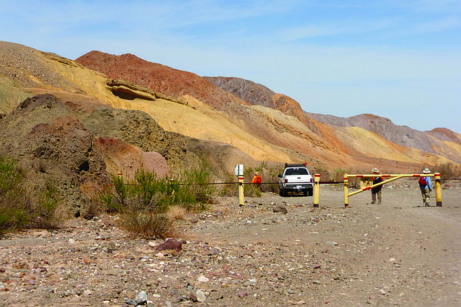
From the fork in the road (5 miles from the turnoff from Imperial County S-80/Evan Hewes Highway), the main road has a Bureau of Land Management (BLM) post, indicating both that this area is managed by BLM and the direction of EC236. Either by four-wheel drive (4WD) vehicle or by foot, continue down this road for about 0.1 mile and then pause to look at the mud bank on your left while you are proceeding north. The slope here reveals some of the underlying geology of the region. You can see the broken shells of the coquina limestone that is characteristic of the Gorge. Another 0.2 mile will bring you down into the Painted Gorge bowl, elevation 525 feet.
You will know you are in the Painted Gorge bowl by the out-of-date BLM notice board sign in the middle of the flat space surrounded by hills. You may want to mark this location, or the place of your parked car, on your GPS, because from here there are multiple roads, official and otherwise. No cell phone reception. In the Painted Gorge bowl, you will need to decide on what type of excursion you wish to embark. Remember, nearly all hikes here are out-and-back, so take note of your surroundings both for their color and for your reference. If you are not sure how far you want to go, keep in mind the old desert hiking tip: go no farther than 1/3 of your water. When you have sipped 1/3 of the amount of water you have carried with you, turn around and go back, saving 2/3 for the hike back.
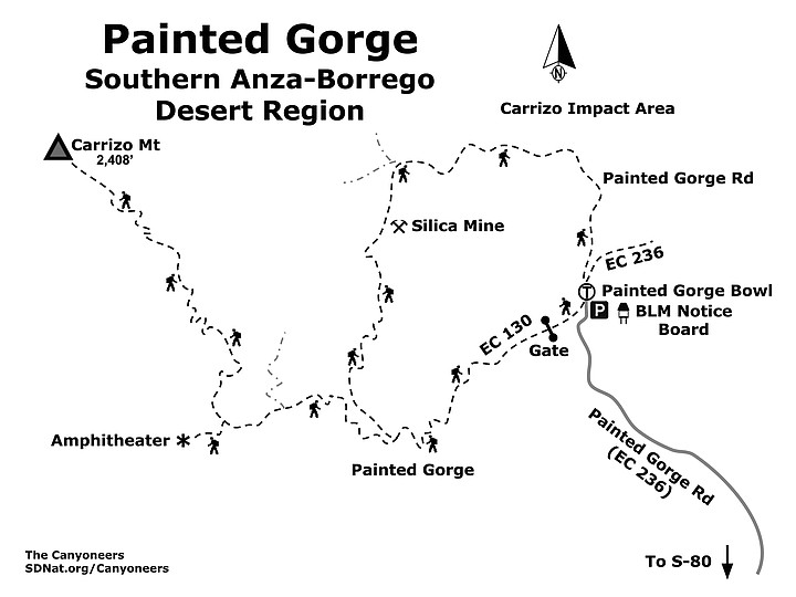
A quick 1-mile hike with a great view involves going directly north of the BLM notice board. Follow a steep, well-used road straight up to a yellow hill. You will know you have reached the summit by the BLM marker indicating the boundary of the Coyote Mountains Wilderness. Due north is the Carrizo Impact Area. To the northeast you can see the Yuha desert. To the south, through the gaps in the mountains, you can look across to Mexico. Return to the bowl.
It is 2.3 miles to the Painted Gorge Amphitheater from the bowl (4.6 miles round trip). Take EC130 forking to the left, past the gated entrance and head west further into Painted Gorge. At 1.1 miles from the bowl (0.9 mile from the gate) is an optional hike north to a silica mine. A visit to this mine, there and back to EC130, will add 2 more miles to your trip. From this hike turnoff, continue up the Painted Gorge road to another fork where you turn left (to the west) and continue another half a mile to reach the Painted Gorge Amphitheater. Here you will find mudhills embedded with shells from an ancient sea.
If you prefer a 3-mile loop trip, go north on the trail headed to the silica mine prospecting site from EC130, 1.1 miles from the bowl. The steep trail hugs the brink of a canyon to the mining site and continues north past other prospecting sites. It then arcs to the east and joins a complex of old Jeep roads around to EC 236 where you can head south back to the bowl, passing the view point in the short hike described above.
You can also hike to the summit of Carrizo Mountain, which is a strenuous 3.7 miles from the bowl (7.5 miles round trip). From the fork in the road that leads to the amphitheater (1.9 miles from the notice board in the bowl), take the right fork up the mountain for an overview of the amphitheater and continue climbing upward on the old Jeep road. This 2,408-foot peak has sweeping vistas of the Carrizo Badlands, Fish Creek Mountains to the north, across to the Jacumba Wilderness, and south to the mountains of Constitution of 1867 National Park (Parque Nacional Constitución de 1957) in Mexico.
This area also offers other options for exploring with a 4WD vehicle. Best to be prepared with both detailed BLM road maps and USGS topographic maps. A good resource for overall geology of this fascinating area is the San Diego Association of Geologists publication entitled Geology of the Coyote Mountains. During the season when the Painted Gorge Road EC130 is open, 4WD vehicles can drive to the amphitheater. If you want to avoid vehicles, be sure to plan your hike after January 1, when the road is closed to vehicles during bighorn sheep lambing season.
PAINTED GORGE (Southern Anza-Borrego Desert Region)
Walk along the brightly visible geology of this section of the Coyote Mountains
Painted Gorge map
- Driving directions: (Ocotillo) Drive east on I-8 into Imperial County and take Exit 89 in Ocotillo. Turn left to go north under the freeway and then head immediately right and continue east down Evan Hewes Highway (Imperial County S-80/Historic US 80), which starts as a frontage road. Continue for 4.2 miles. Painted Gorge Road will be on your left just before the Plaster City ORV sign. NOTE: If the bridge is out on Evan Hewes Highway, then you will need to get back on I-8 East and drive 11.6 miles to Exit 101 Dunaway Road, go north under the freeway, and turn west on Evan Hewes Highway, passing the north turn to Plaster City to reach the Painted Gorge Road, 4.9 miles from the Plaster City turnoff. Painted Gorge Road is a graded dirt road and becomes labeled BLM road EC236. Drive 5 miles to where the road forks. The main road, EC236, continues to the right and becomes a 4WD road. You may park here and proceed on foot, or if you feel comfortable, drive the remaining 0.3 mile to the Painted Gorge bowl. If the gate is open, vehicles can drive to Painted Gorge Amphitheatre (another 2.3 miles). NOTE: The gate is open for vehicles between July 1 and December 31, closed to protect the bighorn sheep during lambing season January 1 through June 30. Hiking length: Variable depending on route and objective – 1 mile, 4.6 miles, 3 miles, 7.5 miles Various portions can be accessed by vehicle before gate closure. Difficulty: Easy to very difficult with up to 1,883 feet change in elevation. No facilities.
Here's something you might be interested in.
The Painted Gorge: from under the sea to desert region
Ancient seas and minor impurities in granitic and volcanic rocks give rise to the vivid colors
The Painted Gorge: from under the sea to desert region
Ancient seas and minor impurities in granitic and volcanic rocks give rise to the vivid colors
Ancient seas and minor impurities give rise to the vivid colors.
The Painted Gorge near Ocotillo and Plaster City offers the opportunity to explore the brightly colored mud hills of an ancient marine layer and volcanic flows. This particular excursion is of variable length and difficulty, ranging from a quick side trip (less than 1 hour) to a serious hike, so be sure to plan ahead.
The hills, formations, and drainage are soft but distinct pastel colors. Ancient seas and minor impurities in granitic and volcanic rocks give rise to the vivid colors. As in most “painted” regions of the world, the leading source of color is iron. In its oxidized state, as in exposed to the air, it rusts. Iron traces in geological formations then create a red-tone. When iron “reduces” or is in a low oxygen environment, like underwater in an ancient sea, it can turn a geological formation green. In the Painted Gorge, the colors can tell you something about the underlying geology. Here, the main Imperial Formation is a marine layer, and mostly a soft yellow color from the sulfur-oxides in the soil. The brilliant blues are from the Alverson volcanic layer that also carries the colorful irons.
The Painted Gorge area is a place of contradictions. Now a desert, 450 million years ago this part of North America was under the sea. The area does not lend itself to conventional agriculture. Viewed by some as a wasteland, from 1942-1959 the area just to the north, the Carrizo Impact Area, was used as a bombing range to test and train during World War II and the primary part of the Korean War. The red iron-oxidized mountaintops made the perfect bulls-eye for bombers and gunners. To the northeast and visible from Carrizo Mountain, the Salton Sea fills the below sea level basin. While the current body of water was the result of an irrigation accident in 1905, its predecessor, the much larger ancient Lake Cahuilla, was a Colorado River spillover that filled the basin several times over hundreds of years to the 42-foot elevation level only to shrink and periodically dry up. The records of these inundations are attested to in oral histories and documented in geological and archaeological research.
The region’s history as a major route is multi-cultural. The Kumeyaay moved back and forth from desert to coast, explorer Juan Baptista de Anza crossed the region, the Butterfield Overland Stage route crosses just to the north of Painted Gorge, and I-8 (San Diego’s main eastbound freeway) is just a few miles to the south.
From the fork in the road (5 miles from the turnoff from Imperial County S-80/Evan Hewes Highway), the main road has a Bureau of Land Management (BLM) post, indicating both that this area is managed by BLM and the direction of EC236. Either by four-wheel drive (4WD) vehicle or by foot, continue down this road for about 0.1 mile and then pause to look at the mud bank on your left while you are proceeding north. The slope here reveals some of the underlying geology of the region. You can see the broken shells of the coquina limestone that is characteristic of the Gorge. Another 0.2 mile will bring you down into the Painted Gorge bowl, elevation 525 feet.
You will know you are in the Painted Gorge bowl by the out-of-date BLM notice board sign in the middle of the flat space surrounded by hills. You may want to mark this location, or the place of your parked car, on your GPS, because from here there are multiple roads, official and otherwise. No cell phone reception. In the Painted Gorge bowl, you will need to decide on what type of excursion you wish to embark. Remember, nearly all hikes here are out-and-back, so take note of your surroundings both for their color and for your reference. If you are not sure how far you want to go, keep in mind the old desert hiking tip: go no farther than 1/3 of your water. When you have sipped 1/3 of the amount of water you have carried with you, turn around and go back, saving 2/3 for the hike back.
A quick 1-mile hike with a great view involves going directly north of the BLM notice board. Follow a steep, well-used road straight up to a yellow hill. You will know you have reached the summit by the BLM marker indicating the boundary of the Coyote Mountains Wilderness. Due north is the Carrizo Impact Area. To the northeast you can see the Yuha desert. To the south, through the gaps in the mountains, you can look across to Mexico. Return to the bowl.
It is 2.3 miles to the Painted Gorge Amphitheater from the bowl (4.6 miles round trip). Take EC130 forking to the left, past the gated entrance and head west further into Painted Gorge. At 1.1 miles from the bowl (0.9 mile from the gate) is an optional hike north to a silica mine. A visit to this mine, there and back to EC130, will add 2 more miles to your trip. From this hike turnoff, continue up the Painted Gorge road to another fork where you turn left (to the west) and continue another half a mile to reach the Painted Gorge Amphitheater. Here you will find mudhills embedded with shells from an ancient sea.
If you prefer a 3-mile loop trip, go north on the trail headed to the silica mine prospecting site from EC130, 1.1 miles from the bowl. The steep trail hugs the brink of a canyon to the mining site and continues north past other prospecting sites. It then arcs to the east and joins a complex of old Jeep roads around to EC 236 where you can head south back to the bowl, passing the view point in the short hike described above.
You can also hike to the summit of Carrizo Mountain, which is a strenuous 3.7 miles from the bowl (7.5 miles round trip). From the fork in the road that leads to the amphitheater (1.9 miles from the notice board in the bowl), take the right fork up the mountain for an overview of the amphitheater and continue climbing upward on the old Jeep road. This 2,408-foot peak has sweeping vistas of the Carrizo Badlands, Fish Creek Mountains to the north, across to the Jacumba Wilderness, and south to the mountains of Constitution of 1867 National Park (Parque Nacional Constitución de 1957) in Mexico.
This area also offers other options for exploring with a 4WD vehicle. Best to be prepared with both detailed BLM road maps and USGS topographic maps. A good resource for overall geology of this fascinating area is the San Diego Association of Geologists publication entitled Geology of the Coyote Mountains. During the season when the Painted Gorge Road EC130 is open, 4WD vehicles can drive to the amphitheater. If you want to avoid vehicles, be sure to plan your hike after January 1, when the road is closed to vehicles during bighorn sheep lambing season.
PAINTED GORGE (Southern Anza-Borrego Desert Region)
Walk along the brightly visible geology of this section of the Coyote Mountains
Painted Gorge map
- Driving directions: (Ocotillo) Drive east on I-8 into Imperial County and take Exit 89 in Ocotillo. Turn left to go north under the freeway and then head immediately right and continue east down Evan Hewes Highway (Imperial County S-80/Historic US 80), which starts as a frontage road. Continue for 4.2 miles. Painted Gorge Road will be on your left just before the Plaster City ORV sign. NOTE: If the bridge is out on Evan Hewes Highway, then you will need to get back on I-8 East and drive 11.6 miles to Exit 101 Dunaway Road, go north under the freeway, and turn west on Evan Hewes Highway, passing the north turn to Plaster City to reach the Painted Gorge Road, 4.9 miles from the Plaster City turnoff. Painted Gorge Road is a graded dirt road and becomes labeled BLM road EC236. Drive 5 miles to where the road forks. The main road, EC236, continues to the right and becomes a 4WD road. You may park here and proceed on foot, or if you feel comfortable, drive the remaining 0.3 mile to the Painted Gorge bowl. If the gate is open, vehicles can drive to Painted Gorge Amphitheatre (another 2.3 miles). NOTE: The gate is open for vehicles between July 1 and December 31, closed to protect the bighorn sheep during lambing season January 1 through June 30. Hiking length: Variable depending on route and objective – 1 mile, 4.6 miles, 3 miles, 7.5 miles Various portions can be accessed by vehicle before gate closure. Difficulty: Easy to very difficult with up to 1,883 feet change in elevation. No facilities.