Here's something you might be interested in.
Ask a Hipster — Advice you didn't know you needed
Big Screen — Movie commentary
Blurt — Music's inside track
Booze News — San Diego spirits
Classical Music — Immortal beauty
Classifieds — Free and easy
Close to Home — What it’s like on the street where you live
Cover Stories — Front-page features
Drinks All Around — Bartenders' drink recipes
Excerpts — Literary and spiritual excerpts
Feast! — Food & drink reviews
Feature Stories — Local news & stories
Fishing Report — What’s getting hooked from ship and shore
From the Archives — Spotlight on the past
Golden Dreams — Talk of the town
The Gonzo Report — Making the musical scene, or at least reporting from it
Letters — Our inbox
Movies@Home — Local movie buffs share favorites
Movie Reviews — Our critics' picks and pans
Musician Interviews — Up close with local artists
Neighborhood News from Stringers — Hyperlocal news
News Ticker — News & politics
Obermeyer — San Diego politics illustrated
Outdoors — Weekly changes in flora and fauna
Overheard in San Diego — Eavesdropping illustrated
Poetry — The old and the new
Reader Travel — Travel section built by travelers
Reading — The hunt for intellectuals
Roam-O-Rama — SoCal's best hiking/biking trails
San Diego Beer — Inside San Diego suds
SD on the QT — Almost factual news
Sheep and Goats — Places of worship
Special Issues — The best of
Street Style — San Diego streets have style
Surf Diego — Real stories from those braving the waves
Theater — On stage in San Diego this week
Tin Fork — Silver spoon alternative
Under the Radar — Matt Potter's undercover work
Unforgettable — Long-ago San Diego
Unreal Estate — San Diego's priciest pads
Your Week — Daily event picks
Otay Mesa – so unsettled
Sewage, Salt Creek, Otay Mountain, Brown Field, Otay Park, border fence, tunnels, new border entry, Nestor High School
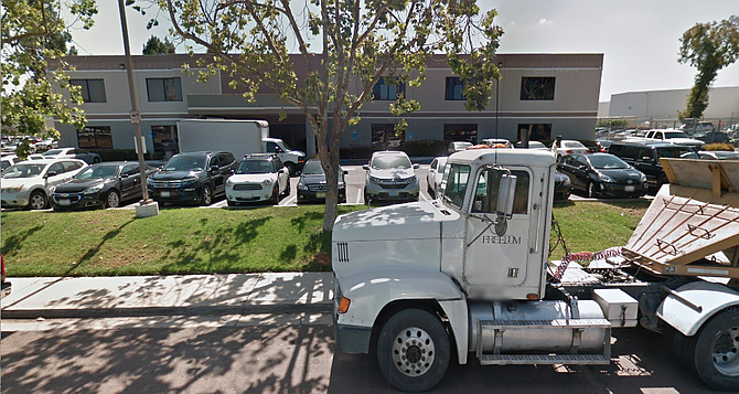
All kinds of trucks use the streets surrounding 1275 30th Street in Nestor.
Feds plan to make pond of Tijuana sewage
- Just how smelly are thirteen acres of raw sewage? Soon, very soon, we shall find out. Next Monday a federal agency is planning to start building an open pond for raw sewage just over the border (on the American side), about four miles inland from the ocean. To date no public hearings have been held to discuss the pond’s odoriferousness – or its potential for flooding, or its effect on the local ground water, or, for that matter, any aspect of its operation. “I’ve never seen something move so fast in government,” marveled an aide to county supervisor Tom Hamilton. Commented another observer of the pond-planning process, “It’s an interesting example of how strings can be pulled.”
- By Jeannette DeWyze, April 14, 1983
Bankruptcy menaces Salt Creek
- How long is forever? As it turns out, forever is about two years, or so people in Chula Vista were recently surprised to discover. In March 1996, the County of San Diego and the City of Chula Vista approved the open-space plans for the 23,000-acre Otay Ranch development. As part of the agreement, the landowners, then known as the Baldwin Company, were required to set aside more than half the land for open space and habitat. The agreement was "irrevocable" and "in perpetuity."
- By Nancy Fay, Aug. 8, 2002
Poggi Canyon, sensitive habitat south of Otay Ranch
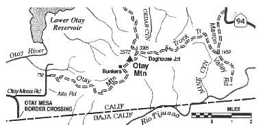
Traverse border-hugging Otay Mountain -- by truck, bike, or foot
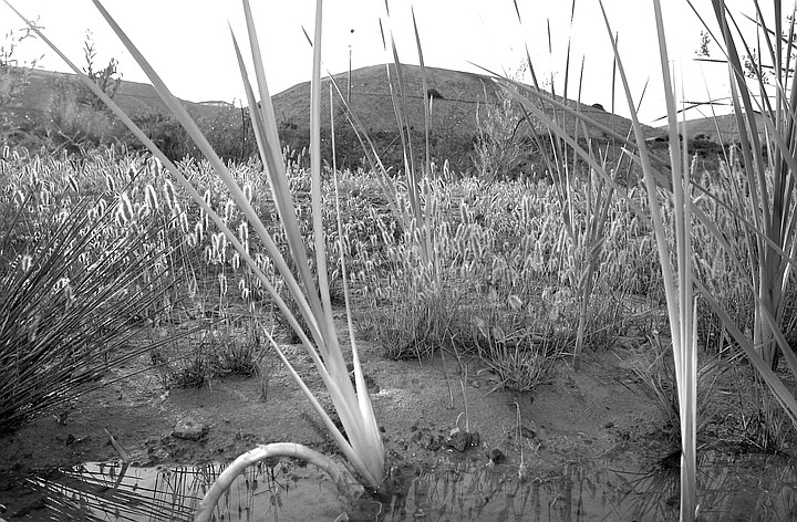
- Rising like a rumpled pillow from the eastern extremity of Otay Mesa, Otay Mountain offers unparalleled, integrated views of the bifurcated San Diego-Tijuana metropolis, the Coronado Islands, Point Loma, and San Diego Bay. Seen on a crystal-clear winter morning, the wide-ranging panorama is almost aerial in perspective and must be seen to be believed. In December 1999, President Clinton signed legislation designating 18,500 acres of the Otay Mountain region as federally protected wilderness.
- By Jerry Schad, Jan. 9, 2003
Otay before 50,000 homes
- In 1954 I sat on the school bus every day next to my best friend, Mark Robson. The ride home from Montgomery Elementary School in Otay was a straight shot east on Main Street. The bus dropped off poor white and Mexican kids until we reached “the Hill,” where Mark and the other black children bounded off and ran up Sycamore Street to ramshackle houses with spacious yards of junked cars, chickens, cows, and pigs fattening in the dirt.
- By Byron Shewman, June 17, 2004
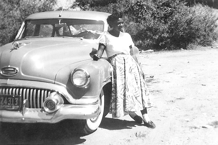
Paradine Ruff on the Hill, c. 1953. When she moved to the outlying burg of Otay, “I cried all the way there. And it was such a long ride in those days.”
Shorten Brown Field's longest runway?
- What is it about Sunroad Enterprises and regional airports? During the same period in which certain City planners were plotting to use Sunroad's defiance of federal and state air safety laws as a pretext to close down Montgomery Field and open it to real estate development, a similar scheme was cooking for Brown Field in Otay Mesa. Sunroad and three other developers -- McMillin, Pardee, and Integral Partners -- were paying consultants to rewrite the Otay Mesa community plan so they could turn industrial parcels they had bought for a song into residential parcels that would turn a fat profit.
- By Don Bauder, July 19, 2007
Why shabby Otay Park cost over $2 million
- Ever wonder why public works cost taxpayers so much? Consider the case of one small project, the new Otay Valley Regional Park ranger station and restroom. Under a joint powers agreement among San Diego County, the City of Chula Vista, and the City of San Diego, local politicians have been trying to develop the park since 1990. The land dedicated to the park extends along the southern border of Chula Vista, then north to the Otay Lakes. The Otay River, which runs through the area, was the site of a great flood supposedly caused by rainmaker Charles Hatfield in 1916.
- By Joe Deegan, Aug. 20, 2008
Clocked by a GoPro stick at border protest
- “My head was opened up with a hit from the GoPro holder,” says Rafael Bautista, one of the founders of Tenants United, Bautista, a City Heights resident, says he was one of the 15 to 20 anti-wall protesters at the border-wall rally held at the east end of Enrico Fermi Place, near the Otay border crossing, on December 9th. Besides him, Bautista says his group consisted of “three children, four or five women, and an elder male.” He says he was expecting a peaceful protest, but the situation heated up really quick.
- By Mike Madriaga, Dec. 15, 2017
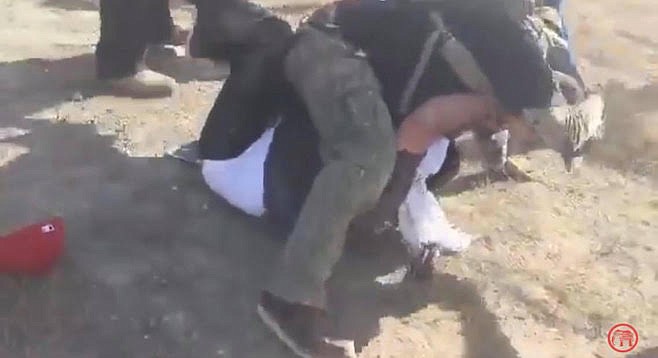
Bautista being attacked by a border-wall booster
State of the U.S.-Mexican border fence in 2009
- Border Patrol agent Richard Gonzales pushes a button in the shiny white Chevy Tahoe he’s driving. In response, a gate rolls open to allow entry to the no-man’s-land between the secondary fence and the old primary fence. Gonzales turns west onto a two-lane graded dirt road between the fences. The view here is striking. On the right towers a 15-foot fence made of a perforated metal similar to a front-door security screen. The fence stretches 13 miles from east of the Otay Mesa port of entry to the ocean.
- By Ernie Grimm, April 29, 2009
Burrowing neighbors trigger near Mexican stand-off
- A group of five possibly armed Mexican military came through the drug tunnel under the border the night of April 1 and tried to exit in an Otay Mesa warehouse being guarded by the Department of Homeland Security and the U.S. Border Patrol, according to U.S. Border Patrol sources and Border Patrol union reports. The Mexicans weren't expected, couldn't produce identification, and prompted an intense response from the two federal agents watching the tunnel.
- By Marty Graham, April 21, 2014
New border entry planned east of Otay
- San Diego is poised to get the first new Southwest border port of entry in at least 30 years, and it's being built as a toll crossing with the main goal of improving commercial-truck wait times. With a target opening date of 2017, the Otay Mesa East port of entry is, yes, east of the Otay port by about two miles. It's going in on SANDAG's direction, with Caltrans providing the roads and Mexico fully supporting the plan.
- By Marty Graham, Jan. 13, 2015
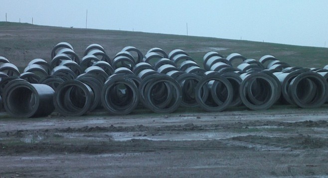
Sections of culvert to be used in border-crossing construction
Another day, another Otay Mesa drug tunnel
- Federal officials announced today (April 20) that they made arrests related to what is believed to be the longest cross-border drug transportation tunnel (800 yards in length), stretching from a house in Tijuana to a commercial lot in an Otay Mesa industrial park.
- By Don Bauder, April 20, 2016
A border agent uncovered the door to the tunnel in an Otay Mesa industrial yard
Nestor high school to fit in industrial zone
- An Otay-Nestor area full of shipping warehouses, dialysis facilities, storage facilities, and a few manufacturing companies may soon get a charter school for a neighbor. The Stephen W. Hawking 2 charter school, which focuses on science, technology, engineering, the arts, and math and now has about 400 students from kindergarten to eighth grade, is planning to move into the office building on the corner of Del Sol Blvd and 30th Street. The school is currently a few blocks away at 27th and Iris on the Southwest Middle School campus. The original school remains in Chula Vista.
- By Marty Graham, Jan. 29, 2018
Here's something you might be interested in.
Otay Mesa – so unsettled
Sewage, Salt Creek, Otay Mountain, Brown Field, Otay Park, border fence, tunnels, new border entry, Nestor High School
Otay Mesa – so unsettled
Sewage, Salt Creek, Otay Mountain, Brown Field, Otay Park, border fence, tunnels, new border entry, Nestor High School
All kinds of trucks use the streets surrounding 1275 30th Street in Nestor.
Feds plan to make pond of Tijuana sewage
- Just how smelly are thirteen acres of raw sewage? Soon, very soon, we shall find out. Next Monday a federal agency is planning to start building an open pond for raw sewage just over the border (on the American side), about four miles inland from the ocean. To date no public hearings have been held to discuss the pond’s odoriferousness – or its potential for flooding, or its effect on the local ground water, or, for that matter, any aspect of its operation. “I’ve never seen something move so fast in government,” marveled an aide to county supervisor Tom Hamilton. Commented another observer of the pond-planning process, “It’s an interesting example of how strings can be pulled.”
- By Jeannette DeWyze, April 14, 1983
Bankruptcy menaces Salt Creek
- How long is forever? As it turns out, forever is about two years, or so people in Chula Vista were recently surprised to discover. In March 1996, the County of San Diego and the City of Chula Vista approved the open-space plans for the 23,000-acre Otay Ranch development. As part of the agreement, the landowners, then known as the Baldwin Company, were required to set aside more than half the land for open space and habitat. The agreement was "irrevocable" and "in perpetuity."
- By Nancy Fay, Aug. 8, 2002
Poggi Canyon, sensitive habitat south of Otay Ranch
Traverse border-hugging Otay Mountain -- by truck, bike, or foot
- Rising like a rumpled pillow from the eastern extremity of Otay Mesa, Otay Mountain offers unparalleled, integrated views of the bifurcated San Diego-Tijuana metropolis, the Coronado Islands, Point Loma, and San Diego Bay. Seen on a crystal-clear winter morning, the wide-ranging panorama is almost aerial in perspective and must be seen to be believed. In December 1999, President Clinton signed legislation designating 18,500 acres of the Otay Mountain region as federally protected wilderness.
- By Jerry Schad, Jan. 9, 2003
Otay before 50,000 homes
- In 1954 I sat on the school bus every day next to my best friend, Mark Robson. The ride home from Montgomery Elementary School in Otay was a straight shot east on Main Street. The bus dropped off poor white and Mexican kids until we reached “the Hill,” where Mark and the other black children bounded off and ran up Sycamore Street to ramshackle houses with spacious yards of junked cars, chickens, cows, and pigs fattening in the dirt.
- By Byron Shewman, June 17, 2004
Paradine Ruff on the Hill, c. 1953. When she moved to the outlying burg of Otay, “I cried all the way there. And it was such a long ride in those days.”
Shorten Brown Field's longest runway?
- What is it about Sunroad Enterprises and regional airports? During the same period in which certain City planners were plotting to use Sunroad's defiance of federal and state air safety laws as a pretext to close down Montgomery Field and open it to real estate development, a similar scheme was cooking for Brown Field in Otay Mesa. Sunroad and three other developers -- McMillin, Pardee, and Integral Partners -- were paying consultants to rewrite the Otay Mesa community plan so they could turn industrial parcels they had bought for a song into residential parcels that would turn a fat profit.
- By Don Bauder, July 19, 2007
Why shabby Otay Park cost over $2 million
- Ever wonder why public works cost taxpayers so much? Consider the case of one small project, the new Otay Valley Regional Park ranger station and restroom. Under a joint powers agreement among San Diego County, the City of Chula Vista, and the City of San Diego, local politicians have been trying to develop the park since 1990. The land dedicated to the park extends along the southern border of Chula Vista, then north to the Otay Lakes. The Otay River, which runs through the area, was the site of a great flood supposedly caused by rainmaker Charles Hatfield in 1916.
- By Joe Deegan, Aug. 20, 2008
Clocked by a GoPro stick at border protest
- “My head was opened up with a hit from the GoPro holder,” says Rafael Bautista, one of the founders of Tenants United, Bautista, a City Heights resident, says he was one of the 15 to 20 anti-wall protesters at the border-wall rally held at the east end of Enrico Fermi Place, near the Otay border crossing, on December 9th. Besides him, Bautista says his group consisted of “three children, four or five women, and an elder male.” He says he was expecting a peaceful protest, but the situation heated up really quick.
- By Mike Madriaga, Dec. 15, 2017
Bautista being attacked by a border-wall booster
State of the U.S.-Mexican border fence in 2009
- Border Patrol agent Richard Gonzales pushes a button in the shiny white Chevy Tahoe he’s driving. In response, a gate rolls open to allow entry to the no-man’s-land between the secondary fence and the old primary fence. Gonzales turns west onto a two-lane graded dirt road between the fences. The view here is striking. On the right towers a 15-foot fence made of a perforated metal similar to a front-door security screen. The fence stretches 13 miles from east of the Otay Mesa port of entry to the ocean.
- By Ernie Grimm, April 29, 2009
Burrowing neighbors trigger near Mexican stand-off
- A group of five possibly armed Mexican military came through the drug tunnel under the border the night of April 1 and tried to exit in an Otay Mesa warehouse being guarded by the Department of Homeland Security and the U.S. Border Patrol, according to U.S. Border Patrol sources and Border Patrol union reports. The Mexicans weren't expected, couldn't produce identification, and prompted an intense response from the two federal agents watching the tunnel.
- By Marty Graham, April 21, 2014
New border entry planned east of Otay
- San Diego is poised to get the first new Southwest border port of entry in at least 30 years, and it's being built as a toll crossing with the main goal of improving commercial-truck wait times. With a target opening date of 2017, the Otay Mesa East port of entry is, yes, east of the Otay port by about two miles. It's going in on SANDAG's direction, with Caltrans providing the roads and Mexico fully supporting the plan.
- By Marty Graham, Jan. 13, 2015
Sections of culvert to be used in border-crossing construction
Another day, another Otay Mesa drug tunnel
- Federal officials announced today (April 20) that they made arrests related to what is believed to be the longest cross-border drug transportation tunnel (800 yards in length), stretching from a house in Tijuana to a commercial lot in an Otay Mesa industrial park.
- By Don Bauder, April 20, 2016
A border agent uncovered the door to the tunnel in an Otay Mesa industrial yard
Nestor high school to fit in industrial zone
- An Otay-Nestor area full of shipping warehouses, dialysis facilities, storage facilities, and a few manufacturing companies may soon get a charter school for a neighbor. The Stephen W. Hawking 2 charter school, which focuses on science, technology, engineering, the arts, and math and now has about 400 students from kindergarten to eighth grade, is planning to move into the office building on the corner of Del Sol Blvd and 30th Street. The school is currently a few blocks away at 27th and Iris on the Southwest Middle School campus. The original school remains in Chula Vista.
- By Marty Graham, Jan. 29, 2018