Here's something you might be interested in.
Ask a Hipster — Advice you didn't know you needed
Big Screen — Movie commentary
Blurt — Music's inside track
Booze News — San Diego spirits
Classical Music — Immortal beauty
Classifieds — Free and easy
Cover Stories — Front-page features
Drinks All Around — Bartenders' drink recipes
Excerpts — Literary and spiritual excerpts
Feast! — Food & drink reviews
Feature Stories — Local news & stories
Fishing Report — What’s getting hooked from ship and shore
From the Archives — Spotlight on the past
Golden Dreams — Talk of the town
The Gonzo Report — Making the musical scene, or at least reporting from it
Letters — Our inbox
Movies@Home — Local movie buffs share favorites
Movie Reviews — Our critics' picks and pans
Musician Interviews — Up close with local artists
Neighborhood News from Stringers — Hyperlocal news
News Ticker — News & politics
Obermeyer — San Diego politics illustrated
Outdoors — Weekly changes in flora and fauna
Overheard in San Diego — Eavesdropping illustrated
Poetry — The old and the new
Reader Travel — Travel section built by travelers
Reading — The hunt for intellectuals
Roam-O-Rama — SoCal's best hiking/biking trails
San Diego Beer — Inside San Diego suds
SD on the QT — Almost factual news
Sheep and Goats — Places of worship
Special Issues — The best of
Street Style — San Diego streets have style
Surf Diego — Real stories from those braving the waves
Theater — On stage in San Diego this week
Tin Fork — Silver spoon alternative
Under the Radar — Matt Potter's undercover work
Unforgettable — Long-ago San Diego
Unreal Estate — San Diego's priciest pads
Your Week — Daily event picks
A biological and geological wonder awaits
Take a hike through one of the largest remaining wetlands in Southern California
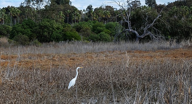
A great egret visits the wetlands of La Orilla
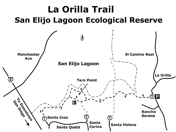
The San Elijo Ecological Reserve protects one of the largest remaining wetlands in Southern California, as well as the bordering hills containing beautiful stands of maritime chaparral and coastal sage scrub. The La Orilla Trail gives you a chance to experience the diverse habitats that make up this biological and geological wonder.
Start hiking through the cool, dark eucalyptus forest near the trailhead. Within the first quarter- mile, the trail passes through riparian vegetation with abundant arroyo and Gooding’s willows, mule fat, and cottonwood trees, intermingled with chaparral and coastal sage scrub species. The wetlands here are fresh water, as La Orilla Creek discharges into the lagoon. You may find a great egret standing among the reeds and hear sound of frogs croaking in the spring.
The trail leaves the wetland and enters into a mixture of coastal sage scrub and maritime chaparral. In addition to scrub oaks, goldenbush, and coyote bush, you can find toyon, lemonadeberry, coast live oak, and Torrey pines, many of which are quite large. Some of the less common plants found here include the fuchsia-flowered gooseberry, blue elderberry, and southern honeysuckle. The birds hiding from you in the brush include spotted towhees and California thrashers — common residents of chaparral and coastal sage scrub — as well as the endangered California gnatcatchers, which live only in Southern California’s coastal sage scrub.
At 0.47 mile from the trailhead, the La Orilla Trail crosses the Santa Helena Trail at right angles. Continue straight ahead on the La Orilla Trail. Almost immediately, you will pass some of the largest and oldest lemonadeberry bushes found anywhere. These are over 20 feet tall, with trunks up to six inches in diameter. They may have never known fire.
The trail now begins to climb up a small knoll called Tern Point. On the way up, you reach one of several viewpoints looking out over the lagoon’s east basin to Manchester Avenue on the other side. It is difficult to identify the vegetation occupying almost the entire basin from this distance, but San Diego sedge and salt grass are known to be abundant in these wetlands. There are only a few patches of open water.
As you approach Tern Point, the trail splits and forms a loop around the Point. Take the trail to the left on the way out and return on the other trail. The trail to the left descends to the La Orilla Trail from the Santa Carina Trailhead.
Although the knoll is called Tern Point, in recent years, no terns have been reported to nest in this part of the lagoon.
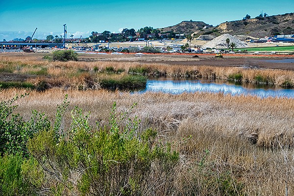
Working to restore the wetlands
However, a substantial amount of restoration work has taken place here. Many eucalyptus trees were removed and hundreds of native species have begun to grow out of their protective cones. Tern Point gives you a good perspective on the extent of the restoration work going on in the lagoon, as well as on the freeway construction.
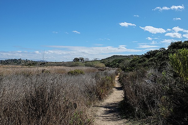
Chaparral on the right, wetlands on the left
At one mile from the La Orilla Trailhead, the trail begins to descend a low ridge, thinly vegetated with coastal sage scrub, while an intermittent stream course below to the left has a thick growth of cottonwoods and willows. Alkali flats are on the right. The trail continues almost as the dividing line between chaparral/coastal sage scrub/riparian vegetation on one side and more salt-tolerant species on the other. At 1.4 miles, the trail turns to the left and crosses the stream course it has been following, continuing for another 0.1 mile to a trail from the Santa Inez Trailhead. This is the end of the trail at the present time. The Dike/Levee Trail and the further reaches of the Santa Inez Trail out into the lagoon are closed due to construction and restoration activity. On your way back out, take a moment to appreciate the tremendous diversity here.
Driving Directions: (Solana Beach) From I-5 , take the Lomas Santa Fe exit (exit 37). Go east on Lomas Santa Fe about 1 mile to Highland Drive. Make a left and continue for 0.5 mile to its junction with El Camino Real. Turn left on El Camino Real and continue for about another 0.5 mile to the La Orilla Trailhead parking on your left. Hiking length: 3 miles, out and back. Allow 2 hours.
Difficulty: Easy. Elevation gain/loss negligible.
Note: Horses and leashed dogs are allowed on the trail. Sections of the trail can be muddy during the winter rainy season.
Here's something you might be interested in.
A biological and geological wonder awaits
Take a hike through one of the largest remaining wetlands in Southern California
A biological and geological wonder awaits
Take a hike through one of the largest remaining wetlands in Southern California
A great egret visits the wetlands of La Orilla
The San Elijo Ecological Reserve protects one of the largest remaining wetlands in Southern California, as well as the bordering hills containing beautiful stands of maritime chaparral and coastal sage scrub. The La Orilla Trail gives you a chance to experience the diverse habitats that make up this biological and geological wonder.
Start hiking through the cool, dark eucalyptus forest near the trailhead. Within the first quarter- mile, the trail passes through riparian vegetation with abundant arroyo and Gooding’s willows, mule fat, and cottonwood trees, intermingled with chaparral and coastal sage scrub species. The wetlands here are fresh water, as La Orilla Creek discharges into the lagoon. You may find a great egret standing among the reeds and hear sound of frogs croaking in the spring.
The trail leaves the wetland and enters into a mixture of coastal sage scrub and maritime chaparral. In addition to scrub oaks, goldenbush, and coyote bush, you can find toyon, lemonadeberry, coast live oak, and Torrey pines, many of which are quite large. Some of the less common plants found here include the fuchsia-flowered gooseberry, blue elderberry, and southern honeysuckle. The birds hiding from you in the brush include spotted towhees and California thrashers — common residents of chaparral and coastal sage scrub — as well as the endangered California gnatcatchers, which live only in Southern California’s coastal sage scrub.
At 0.47 mile from the trailhead, the La Orilla Trail crosses the Santa Helena Trail at right angles. Continue straight ahead on the La Orilla Trail. Almost immediately, you will pass some of the largest and oldest lemonadeberry bushes found anywhere. These are over 20 feet tall, with trunks up to six inches in diameter. They may have never known fire.
The trail now begins to climb up a small knoll called Tern Point. On the way up, you reach one of several viewpoints looking out over the lagoon’s east basin to Manchester Avenue on the other side. It is difficult to identify the vegetation occupying almost the entire basin from this distance, but San Diego sedge and salt grass are known to be abundant in these wetlands. There are only a few patches of open water.
As you approach Tern Point, the trail splits and forms a loop around the Point. Take the trail to the left on the way out and return on the other trail. The trail to the left descends to the La Orilla Trail from the Santa Carina Trailhead.
Although the knoll is called Tern Point, in recent years, no terns have been reported to nest in this part of the lagoon.
Working to restore the wetlands
However, a substantial amount of restoration work has taken place here. Many eucalyptus trees were removed and hundreds of native species have begun to grow out of their protective cones. Tern Point gives you a good perspective on the extent of the restoration work going on in the lagoon, as well as on the freeway construction.
Chaparral on the right, wetlands on the left
At one mile from the La Orilla Trailhead, the trail begins to descend a low ridge, thinly vegetated with coastal sage scrub, while an intermittent stream course below to the left has a thick growth of cottonwoods and willows. Alkali flats are on the right. The trail continues almost as the dividing line between chaparral/coastal sage scrub/riparian vegetation on one side and more salt-tolerant species on the other. At 1.4 miles, the trail turns to the left and crosses the stream course it has been following, continuing for another 0.1 mile to a trail from the Santa Inez Trailhead. This is the end of the trail at the present time. The Dike/Levee Trail and the further reaches of the Santa Inez Trail out into the lagoon are closed due to construction and restoration activity. On your way back out, take a moment to appreciate the tremendous diversity here.
Driving Directions: (Solana Beach) From I-5 , take the Lomas Santa Fe exit (exit 37). Go east on Lomas Santa Fe about 1 mile to Highland Drive. Make a left and continue for 0.5 mile to its junction with El Camino Real. Turn left on El Camino Real and continue for about another 0.5 mile to the La Orilla Trailhead parking on your left. Hiking length: 3 miles, out and back. Allow 2 hours.
Difficulty: Easy. Elevation gain/loss negligible.
Note: Horses and leashed dogs are allowed on the trail. Sections of the trail can be muddy during the winter rainy season.
Comments