Here's something you might be interested in.
Ask a Hipster — Advice you didn't know you needed
Big Screen — Movie commentary
Blurt — Music's inside track
Booze News — San Diego spirits
Classical Music — Immortal beauty
Classifieds — Free and easy
Close to Home — What it’s like on the street where you live
Cover Stories — Front-page features
Drinks All Around — Bartenders' drink recipes
Excerpts — Literary and spiritual excerpts
Feast! — Food & drink reviews
Feature Stories — Local news & stories
Fishing Report — What’s getting hooked from ship and shore
From the Archives — Spotlight on the past
Golden Dreams — Talk of the town
The Gonzo Report — Making the musical scene, or at least reporting from it
Letters — Our inbox
Movies@Home — Local movie buffs share favorites
Movie Reviews — Our critics' picks and pans
Musician Interviews — Up close with local artists
Neighborhood News from Stringers — Hyperlocal news
News Ticker — News & politics
Obermeyer — San Diego politics illustrated
Outdoors — Weekly changes in flora and fauna
Overheard in San Diego — Eavesdropping illustrated
Poetry — The old and the new
Reader Travel — Travel section built by travelers
Reading — The hunt for intellectuals
Roam-O-Rama — SoCal's best hiking/biking trails
San Diego Beer — Inside San Diego suds
SD on the QT — Almost factual news
Sheep and Goats — Places of worship
Special Issues — The best of
Street Style — San Diego streets have style
Surf Diego — Real stories from those braving the waves
Theater — On stage in San Diego this week
Tin Fork — Silver spoon alternative
Under the Radar — Matt Potter's undercover work
Unforgettable — Long-ago San Diego
Unreal Estate — San Diego's priciest pads
Your Week — Daily event picks
Be careful near the monument — often home to a beehive.
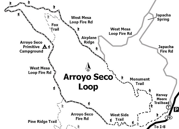
Arroyo Seco Loop off Highway 79
Thumb Rock — as the loop makes U-turn
Wide sweeping views? Check. An aircraft engine from the 1920s? Check. Bedrock morteros at a peaceful backcountry trail camp? Check. This loop hike includes the entire length of Airplane Ridge, breezes by interesting rock formations, drops down into the grassland meadows of Arroyo Seco Trail Camp, and skirts the banks of the Sweetwater River.

As you climb up the ridge, patches of goldenbush and goldenrod dot the slopes.
Enjoy the variety of flora as you climb through chaparral, oak woodland, and a bit of mixed conifer forest on this hike located only an hour from San Diego. Portions of this route are on exposed south-facing slopes, so the best months to hike it are September through May.
The Army pilots turned the plane around to avoid bad weather.
Once parked, carefully cross Highway 79 and walk north over the bridge to find the Connector Trail just on the other side to the left (east). Follow this trail a short distance as it crosses a grassy field and intersects the West Side Trail.
The Arroyo Seco Trail junction is the highest point of the loop.
Turn left here, passing in and out of the shade of pine trees and coast live oaks that survived the 2003 Cedar Fire, with an understory of common snowberry. The strip of lush vegetation to your left marks the southwesterly flow of the Sweetwater River as it makes its way to Green Valley Falls and beyond. Because of the nearby water source, on warmer days, this stretch of trail can be buggy, so protective clothing or insect repellant may be desired.
After 0.7 mile from the start, reach the junction with the Monument Trail. Turn right here, and climb northward through rockier terrain as the trail passes through a mixed chaparral and oak woodland landscape. Commonly seen plants include flat-top buckwheat, manzanita, basket bush, and chaparral whitethorn. As you climb higher up the ridge, healthy patches of goldenbush and goldenrod dot the slopes with their bright yellow flowers. Oakzanita Peak is seen to the southeast, and the grassy plateau of East Mesa that rises high above the Highway 79 corridor. The trail makes a long switchback and rounds a corner where a few large rocks tucked under some trees make for a nice water break.
Moving along, the trail turns northwest as it continues to climb Airplane Ridge. To the north the tip of Stonewall Peak pokes above West Mesa, and soon the entire mountain comes into view. Pass by the shrub-carpeted 4781-foot peak to your left, and notice Cuyamaca and Japacha Peaks to the northwest. After about 700 feet of climbing from the previous junction, reach the West Mesa Trail at 2.2 miles from the start.
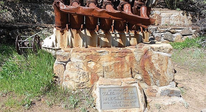
For a short side-trip, turn right at this junction and follow signs for the Airplane Monument, a memorial containing a 12-cylinder aircraft engine recovered from an Army biplane that crashed here on December 7, 1922, killing both occupants after they had turned the plane around to avoid bad weather and experienced engine trouble. The mounted engine block has a plaque to commemorate the men, but use caution when approaching the monument, as it is often home to a beehive.
Retrace your steps uphill 0.2 mile and continue atop Airplane Ridge on the West Mesa Trail as it rambles along, gradually climbing another 200 feet in elevation. Far-reaching views open up to the south and west as the trail continues by scrub oak and white sage interspersed with yucca, coffee berry, and small coulter pines. Turn a corner and Japacha Peak looms straight ahead almost 1000 feet higher. After hiking approximately 3.4 miles and ascending to 4970 feet in elevation is the Arroyo Seco Trail junction, the highest point of the loop and a good time for a break.
Turn left onto the Arroyo Seco Trail, as it gradually loses elevation and becomes a wider path cutting across the lower slopes of Japacha Peak. Pass by the Fox Trail on the left and continue west with views to the distant Viejas and El Cajon Mountains. As the trail makes a big U-turn at the westernmost point, spot an interesting rock a short distance off the trail that looks like an upward-pointed thumb. Continue around the bend as the trail heads southeasterly and passes by California sycamores and grassland areas to Arroyo Seco Trail Camp. Walk past the lower junction of the Fox Trail, and after 0.1 mile is the primitive campground. Straight ahead are three horse corrals and pit toilets. A short side path to the left leads to campsites #2 and #3, each with a picnic table and space for a couple of tents. To the right, paths lead to a water pump and trough (not suitable for drinking or cooking) and the Group Camp. Next to the group site are several bedrock morteros and large oak trees. Find a shady spot to rest, as you are now over 5 miles into the hike and more than halfway around the loop.
From the campground, continue on what is now the Arroyo Seco Fire Road. Site #1 is passed on the southern outskirts of the trail camp marked by a numbered post on your right. Follow the wide, gently descending fire road 0.6 mile through grasslands dotted with oak groves and a smattering of tall pine trees. Keep straight at the junction with the South Boundary Fire Road, and in another 0.6 mile spot the West Side Trail on your left. Turn here and make a short climb through tall thickets of chaparral whitethorn to the next junction in 0.3 mile. To the right is a trail heading toward Green Valley Campground, but veer left instead to stay on the West Side Trail. A short stretch later, reach the Monument Trail on your left, closing the loop portion of the hike. Stay straight on the West Side Trail and soon Highway 79 will come into view once again. Be sure not to miss the Connector Trail 0.6 mile later on the right and the home stretch back to the highway and your vehicle on the other side, a satisfying 7.5 miles for the day.
To stay overnight at Arroyo Seco Trail Camp, reservations are required via either reservecalifornia.com or call-1-800-444-7275. Overnight parking information can be obtained by checking in with the Green Valley Campground entrance station.
Distance from downtown San Diego: 47 miles (Cuyamaca Mountains). Allow 60 minutes driving time. From I-8, exit north onto Highway 79 for 2.6 miles before turning. Turn left to continue on Highway 79 for 4.9 miles to the large Sweetwater parking area on the right, just before the Sweetwater Bridge, one-half mile past the Green Valley Falls Campground. A chemical toilet may be in the parking lot. Hiking length: 7.5-mile loop.
Difficulty: Moderate. Elevation gain/loss 1040 feet. Trail junctions are well marked and easy to follow.
Here's something you might be interested in.
Be careful near the monument — often home to a beehive.
Arroyo Seco Loop off Highway 79
Be careful near the monument — often home to a beehive.
Arroyo Seco Loop off Highway 79
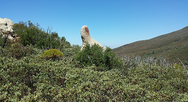
Thumb Rock — as the loop makes U-turn
Wide sweeping views? Check. An aircraft engine from the 1920s? Check. Bedrock morteros at a peaceful backcountry trail camp? Check. This loop hike includes the entire length of Airplane Ridge, breezes by interesting rock formations, drops down into the grassland meadows of Arroyo Seco Trail Camp, and skirts the banks of the Sweetwater River.
As you climb up the ridge, patches of goldenbush and goldenrod dot the slopes.
Enjoy the variety of flora as you climb through chaparral, oak woodland, and a bit of mixed conifer forest on this hike located only an hour from San Diego. Portions of this route are on exposed south-facing slopes, so the best months to hike it are September through May.
The Army pilots turned the plane around to avoid bad weather.
Once parked, carefully cross Highway 79 and walk north over the bridge to find the Connector Trail just on the other side to the left (east). Follow this trail a short distance as it crosses a grassy field and intersects the West Side Trail.
The Arroyo Seco Trail junction is the highest point of the loop.
Turn left here, passing in and out of the shade of pine trees and coast live oaks that survived the 2003 Cedar Fire, with an understory of common snowberry. The strip of lush vegetation to your left marks the southwesterly flow of the Sweetwater River as it makes its way to Green Valley Falls and beyond. Because of the nearby water source, on warmer days, this stretch of trail can be buggy, so protective clothing or insect repellant may be desired.
After 0.7 mile from the start, reach the junction with the Monument Trail. Turn right here, and climb northward through rockier terrain as the trail passes through a mixed chaparral and oak woodland landscape. Commonly seen plants include flat-top buckwheat, manzanita, basket bush, and chaparral whitethorn. As you climb higher up the ridge, healthy patches of goldenbush and goldenrod dot the slopes with their bright yellow flowers. Oakzanita Peak is seen to the southeast, and the grassy plateau of East Mesa that rises high above the Highway 79 corridor. The trail makes a long switchback and rounds a corner where a few large rocks tucked under some trees make for a nice water break.
Moving along, the trail turns northwest as it continues to climb Airplane Ridge. To the north the tip of Stonewall Peak pokes above West Mesa, and soon the entire mountain comes into view. Pass by the shrub-carpeted 4781-foot peak to your left, and notice Cuyamaca and Japacha Peaks to the northwest. After about 700 feet of climbing from the previous junction, reach the West Mesa Trail at 2.2 miles from the start.
For a short side-trip, turn right at this junction and follow signs for the Airplane Monument, a memorial containing a 12-cylinder aircraft engine recovered from an Army biplane that crashed here on December 7, 1922, killing both occupants after they had turned the plane around to avoid bad weather and experienced engine trouble. The mounted engine block has a plaque to commemorate the men, but use caution when approaching the monument, as it is often home to a beehive.
Retrace your steps uphill 0.2 mile and continue atop Airplane Ridge on the West Mesa Trail as it rambles along, gradually climbing another 200 feet in elevation. Far-reaching views open up to the south and west as the trail continues by scrub oak and white sage interspersed with yucca, coffee berry, and small coulter pines. Turn a corner and Japacha Peak looms straight ahead almost 1000 feet higher. After hiking approximately 3.4 miles and ascending to 4970 feet in elevation is the Arroyo Seco Trail junction, the highest point of the loop and a good time for a break.
Turn left onto the Arroyo Seco Trail, as it gradually loses elevation and becomes a wider path cutting across the lower slopes of Japacha Peak. Pass by the Fox Trail on the left and continue west with views to the distant Viejas and El Cajon Mountains. As the trail makes a big U-turn at the westernmost point, spot an interesting rock a short distance off the trail that looks like an upward-pointed thumb. Continue around the bend as the trail heads southeasterly and passes by California sycamores and grassland areas to Arroyo Seco Trail Camp. Walk past the lower junction of the Fox Trail, and after 0.1 mile is the primitive campground. Straight ahead are three horse corrals and pit toilets. A short side path to the left leads to campsites #2 and #3, each with a picnic table and space for a couple of tents. To the right, paths lead to a water pump and trough (not suitable for drinking or cooking) and the Group Camp. Next to the group site are several bedrock morteros and large oak trees. Find a shady spot to rest, as you are now over 5 miles into the hike and more than halfway around the loop.
From the campground, continue on what is now the Arroyo Seco Fire Road. Site #1 is passed on the southern outskirts of the trail camp marked by a numbered post on your right. Follow the wide, gently descending fire road 0.6 mile through grasslands dotted with oak groves and a smattering of tall pine trees. Keep straight at the junction with the South Boundary Fire Road, and in another 0.6 mile spot the West Side Trail on your left. Turn here and make a short climb through tall thickets of chaparral whitethorn to the next junction in 0.3 mile. To the right is a trail heading toward Green Valley Campground, but veer left instead to stay on the West Side Trail. A short stretch later, reach the Monument Trail on your left, closing the loop portion of the hike. Stay straight on the West Side Trail and soon Highway 79 will come into view once again. Be sure not to miss the Connector Trail 0.6 mile later on the right and the home stretch back to the highway and your vehicle on the other side, a satisfying 7.5 miles for the day.
To stay overnight at Arroyo Seco Trail Camp, reservations are required via either reservecalifornia.com or call-1-800-444-7275. Overnight parking information can be obtained by checking in with the Green Valley Campground entrance station.
Distance from downtown San Diego: 47 miles (Cuyamaca Mountains). Allow 60 minutes driving time. From I-8, exit north onto Highway 79 for 2.6 miles before turning. Turn left to continue on Highway 79 for 4.9 miles to the large Sweetwater parking area on the right, just before the Sweetwater Bridge, one-half mile past the Green Valley Falls Campground. A chemical toilet may be in the parking lot. Hiking length: 7.5-mile loop.
Difficulty: Moderate. Elevation gain/loss 1040 feet. Trail junctions are well marked and easy to follow.
Comments