Here's something you might be interested in.
Ask a Hipster — Advice you didn't know you needed
Big Screen — Movie commentary
Blurt — Music's inside track
Booze News — San Diego spirits
Classical Music — Immortal beauty
Classifieds — Free and easy
Close to Home — What it’s like on the street where you live
Cover Stories — Front-page features
Drinks All Around — Bartenders' drink recipes
Excerpts — Literary and spiritual excerpts
Feast! — Food & drink reviews
Feature Stories — Local news & stories
Fishing Report — What’s getting hooked from ship and shore
From the Archives — Spotlight on the past
Golden Dreams — Talk of the town
The Gonzo Report — Making the musical scene, or at least reporting from it
Letters — Our inbox
Movies@Home — Local movie buffs share favorites
Movie Reviews — Our critics' picks and pans
Musician Interviews — Up close with local artists
Neighborhood News from Stringers — Hyperlocal news
News Ticker — News & politics
Obermeyer — San Diego politics illustrated
Outdoors — Weekly changes in flora and fauna
Overheard in San Diego — Eavesdropping illustrated
Poetry — The old and the new
Reader Travel — Travel section built by travelers
Reading — The hunt for intellectuals
Roam-O-Rama — SoCal's best hiking/biking trails
San Diego Beer — Inside San Diego suds
SD on the QT — Almost factual news
Sheep and Goats — Places of worship
Special Issues — The best of
Street Style — San Diego streets have style
Surf Diego — Real stories from those braving the waves
Theater — On stage in San Diego this week
Tin Fork — Silver spoon alternative
Under the Radar — Matt Potter's undercover work
Unforgettable — Long-ago San Diego
Unreal Estate — San Diego's priciest pads
Your Week — Daily event picks
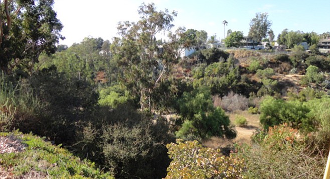
Look low in Switzer Canyon for the dusky-footed woodrat
Scrub oaks, ice plant, wild cucumber, toyon berry, laurel sumac, and endangered California gnatcatchers
You will smell the sage before seeing it.
Switzer Canyon offers a hike for those with short legs and short attention spans — a kid-friendly urban walk that can be either a 30-minute or a one-hour hike. This is an example of a coastal sage scrub habitat that provides shelter for the endangered California gnatcatcher, a bird.
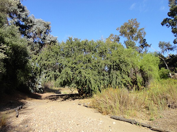
The stream bed becomes the trail as it continues easterly.
At the entrance sign, proceed to your left/west down the service road until the bottom of the canyon. Note to the left are examples of scrub oaks, ice plant, and wild cucumber. Nearing the bottom, look toward the right and notice a grove of toyon/Christmas berry and laurel sumac, both native to this area. The service road ends at the bottom next to the 30th Street land bridge.
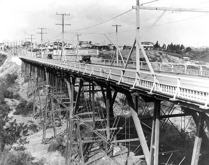
Original trestle bridge over Switzer Canyon, circa 1930s
Switzer Canyon was the boundary between the neighborhoods of North Park and South Park. The land bridge replaced a trestle bridge in 1957. Notice areas of California flat-topped buckwheat and black sage. You will smell the sage before seeing it. There’s a kiosk at the canyon bottom. Proceed easterly, and in about 100 yards are some old foundations. There was an isolation encampment here in the 1880s during the smallpox epidemic. Also on this canyon floor is a Chinese lace tree. Look at the odd-looking bark under its canopy. The floor will give way to a stream bed that shows the results of the heavy rains from last winter. Further up the canyon floor, plots of yerba santa and evening primrose compete with nonnative varietals.
This urban walk can be a 30-minute or a one-hour hike.
The stream bed becomes the trail as it continues easterly. Stands of prickly pear cactus and some agave will appear on both sides of the trail. As the trail closes in, look underneath the overgrowth for the haphazard stick homes of the dusky-footed wood rat. Some of this trail will start to be rough going due to the rain erosion. Note the stand of large reeds on the edge of one of the finger canyons. This is giant reed or Arundo donax, which is invasive and hard to eradicate. Beyond this point the trail narrows, ending abruptly on the downside of a neighborhood home. Turn and head back. Crossing the streambed for the last time, look up to the left and you will see the grove of Peruvian pepper trees you saw at the start of the walk.
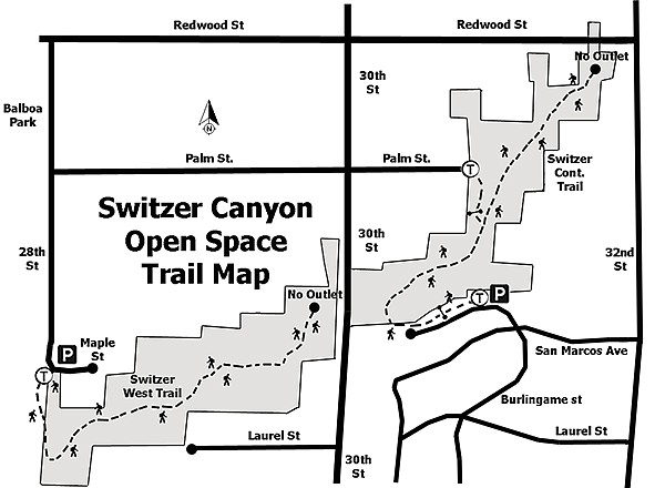
The western end of Switzer Canyon is at the corner of 28th Street and Maple, near the eastern edge of Balboa Park Golf Course. Proceed easterly for about a half mile. This is an out-and-back hike from here with the turnaround at 30th Street. This side of the canyon has benefitted from some restoration by the members of San Diego Canyonlands (sdcanyonlands.org). In fact, 20 years ago, the Sierra Club led a hike in this canyon that led to the creation of the first “friends” group for a local canyon.
Distance from downtown San Diego: 2.7 miles (San Diego). Allow 10 minutes driving time. Drive east on Broadway then left (north) onto 19th Street and from the right lanes merge onto the Pershing Drive ramp. Veer right (east) onto Redwood Street then right (south) onto 32nd Street. Turn right (west) on San Marcos Avenue and park along the street near the corner of Burlingame Drive and walk north onto Burlingame Drive for approximately 300 feet where it becomes a service street. This is the entrance. The Switzer Canyon sign is obscured by overgrown Peruvian pepper trees. Dip under the trees to begin the hike.
Hiking length: 1-mile round trip. Allow 30–60 minutes.
Difficulty: Easy, with descent into the canyon following a service road. Dogs must be leashed at all times.
Here's something you might be interested in.
Look low in Switzer Canyon for the dusky-footed woodrat
Scrub oaks, ice plant, wild cucumber, toyon berry, laurel sumac, and endangered California gnatcatchers
Look low in Switzer Canyon for the dusky-footed woodrat
Scrub oaks, ice plant, wild cucumber, toyon berry, laurel sumac, and endangered California gnatcatchers
You will smell the sage before seeing it.
Switzer Canyon offers a hike for those with short legs and short attention spans — a kid-friendly urban walk that can be either a 30-minute or a one-hour hike. This is an example of a coastal sage scrub habitat that provides shelter for the endangered California gnatcatcher, a bird.
The stream bed becomes the trail as it continues easterly.
At the entrance sign, proceed to your left/west down the service road until the bottom of the canyon. Note to the left are examples of scrub oaks, ice plant, and wild cucumber. Nearing the bottom, look toward the right and notice a grove of toyon/Christmas berry and laurel sumac, both native to this area. The service road ends at the bottom next to the 30th Street land bridge.
Original trestle bridge over Switzer Canyon, circa 1930s
Switzer Canyon was the boundary between the neighborhoods of North Park and South Park. The land bridge replaced a trestle bridge in 1957. Notice areas of California flat-topped buckwheat and black sage. You will smell the sage before seeing it. There’s a kiosk at the canyon bottom. Proceed easterly, and in about 100 yards are some old foundations. There was an isolation encampment here in the 1880s during the smallpox epidemic. Also on this canyon floor is a Chinese lace tree. Look at the odd-looking bark under its canopy. The floor will give way to a stream bed that shows the results of the heavy rains from last winter. Further up the canyon floor, plots of yerba santa and evening primrose compete with nonnative varietals.
This urban walk can be a 30-minute or a one-hour hike.
The stream bed becomes the trail as it continues easterly. Stands of prickly pear cactus and some agave will appear on both sides of the trail. As the trail closes in, look underneath the overgrowth for the haphazard stick homes of the dusky-footed wood rat. Some of this trail will start to be rough going due to the rain erosion. Note the stand of large reeds on the edge of one of the finger canyons. This is giant reed or Arundo donax, which is invasive and hard to eradicate. Beyond this point the trail narrows, ending abruptly on the downside of a neighborhood home. Turn and head back. Crossing the streambed for the last time, look up to the left and you will see the grove of Peruvian pepper trees you saw at the start of the walk.
The western end of Switzer Canyon is at the corner of 28th Street and Maple, near the eastern edge of Balboa Park Golf Course. Proceed easterly for about a half mile. This is an out-and-back hike from here with the turnaround at 30th Street. This side of the canyon has benefitted from some restoration by the members of San Diego Canyonlands (sdcanyonlands.org). In fact, 20 years ago, the Sierra Club led a hike in this canyon that led to the creation of the first “friends” group for a local canyon.
Distance from downtown San Diego: 2.7 miles (San Diego). Allow 10 minutes driving time. Drive east on Broadway then left (north) onto 19th Street and from the right lanes merge onto the Pershing Drive ramp. Veer right (east) onto Redwood Street then right (south) onto 32nd Street. Turn right (west) on San Marcos Avenue and park along the street near the corner of Burlingame Drive and walk north onto Burlingame Drive for approximately 300 feet where it becomes a service street. This is the entrance. The Switzer Canyon sign is obscured by overgrown Peruvian pepper trees. Dip under the trees to begin the hike.
Hiking length: 1-mile round trip. Allow 30–60 minutes.
Difficulty: Easy, with descent into the canyon following a service road. Dogs must be leashed at all times.
Comments