Here's something you might be interested in.
Ask a Hipster — Advice you didn't know you needed
Big Screen — Movie commentary
Blurt — Music's inside track
Booze News — San Diego spirits
Classical Music — Immortal beauty
Classifieds — Free and easy
Close to Home — What it’s like on the street where you live
Cover Stories — Front-page features
Drinks All Around — Bartenders' drink recipes
Excerpts — Literary and spiritual excerpts
Feast! — Food & drink reviews
Feature Stories — Local news & stories
Fishing Report — What’s getting hooked from ship and shore
From the Archives — Spotlight on the past
Golden Dreams — Talk of the town
The Gonzo Report — Making the musical scene, or at least reporting from it
Letters — Our inbox
Movies@Home — Local movie buffs share favorites
Movie Reviews — Our critics' picks and pans
Musician Interviews — Up close with local artists
Neighborhood News from Stringers — Hyperlocal news
News Ticker — News & politics
Obermeyer — San Diego politics illustrated
Outdoors — Weekly changes in flora and fauna
Overheard in San Diego — Eavesdropping illustrated
Poetry — The old and the new
Reader Travel — Travel section built by travelers
Reading — The hunt for intellectuals
Roam-O-Rama — SoCal's best hiking/biking trails
San Diego Beer — Inside San Diego suds
SD on the QT — Almost factual news
Sheep and Goats — Places of worship
Special Issues — The best of
Street Style — San Diego streets have style
Surf Diego — Real stories from those braving the waves
Theater — On stage in San Diego this week
Tin Fork — Silver spoon alternative
Under the Radar — Matt Potter's undercover work
Unforgettable — Long-ago San Diego
Unreal Estate — San Diego's priciest pads
Your Week — Daily event picks
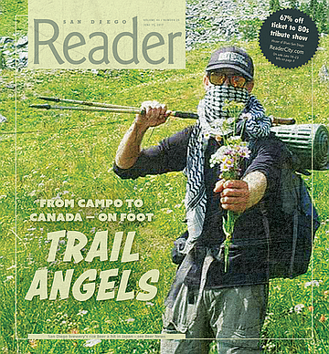
Trail angels: From Campo to Canada on foot
Bread Stick = Trail Food
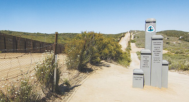
Of the more than 5000 hikers who left from this trailhead marker in 2016, only 700 reported finishing.
North Park, well before the sun is up, Texaspoo and Grams are waiting intently out in front of some small row houses. Texaspoo shows a four-day beard and wears running gear. Grams is rigged out in quick-dry greenish walking shorts, boots with fancy blue coverlets, and layers. Prescription glasses. Both are lean as greyhounds. Texaspoo polishes off a smoke, claims the Jeep’s front seat and immediately goes to texting. Grams studies the best possibilities to secure a two-foot store-wrapped stick of French bread onto his pack. These are men who think nothing of gathering up a jug of water and some granola bars and leaving civilization on a walkabout for days, even months, at a stretch. On this morning, their attention to the mission at hand is so unwavering that one fears whatever questions are sure to sound stupid.
But — that bread stick.
“That’s some trail food,” Texaspoo answers. He puts weight on the words trail and food. “Dude, you’re always hungry out there.” The glow from his phone screen up lights the mantle of his considerable brow. “With some sharp cheddar, bread like that keeps you going.” He does not look up from whatever message while he talks. “You hike hungry,” he says, “because you burn up about 6000 calories a day.”
He repeats the phrase “out there” again.
Grams says nothing.
“It’s a very complicated thing trying to maintain a trail that extends through three states,” says Mark Larabee of the Pacific Crest Trail Association.
‘Out there’ in this case is the Pacific Crest Trail — 2650 miles of bushwhacked footpath that traverses all three western states. The trail links So Cal with Canada, and it is where the Jeep will deposit Grams in another hour, give or take, at the southern terminus trailhead marker lodged into the hard earth not 50 paces from the U.S./Mexico border.
“What people don’t realize is that 2500 to 3500 people travel to San Diego April through May to hike the PCT.” Grams, Texaspoo says, is one of the many. The April — May launch is about waiting out the bad weather on the Pacific Crest Trail to the north, meaning, the relative condition of the snow pack and the amount of it still on the ground at the higher elevations in Central and Northern California, Oregon, and Washington.

Patrick Seibt — trail name Texaspoo — hikes the Pacific Crest Trail. He’s also completed the Appalachian and Continental Divide trails for a total of 7900 miles.
Talk of having such a trail dates back to the 1920s, but it was Pasadena Playhouse founder Clinton Clarke who got the ball rolling in 1932 by organizing the Pacific Crest Trail System Conference. Thanks to the efforts of dozens of hiking clubs, trail was more or less blazed (or connected using existing roads and trails) between 1935 and 1938 such that today, the Pacific Crest Trail wanders through desert climes in Southern California to ice and snow all the way up in the Cascade Mountains.
Talk quickly returns to the main two uncertainties in the thru-hiker’s trail experience: burning calories, and the amount of food needed to replace them. “At the most,” says Texaspoo, “you can only carry about 4500 calories to replace the 6000 you burn. You’re always in a deficit. You hike hungry,” he says again. He should know; he’s walked that same walk. “I pack,” Grams offers, finally, pensive and tightly wrapped in his own thoughts, “things with a lot of protein. Things I can eat while I walk.”

Rick Rozands wanted to change his trail name, Grams. “I don’t need people to think I’m selling drugs out there.”
Grams is Rick Rozands from Houma, Louisiana. He is 26. He flew in to San Diego for the hike the night before. Texaspoo is Patrick Seibt, 42, a self-employed artist originally from Lubbock. Grams and Texaspoo are trail names; all thru-hikers have them. Thru-hikers carry backpacks and often set up small camps for the night, but the sport is about hiking a long-distance trail from start to finish. Traveling light is mandatory; Rozands is called Grams on the trail because of his routine of weighing every single little thing before it goes in his backpack. Seibt’s trail name came after he took too low of a crouch while snowboarding down the face of a snowpack. As Texaspoo, he has successfully hiked the Pacific Crest Trail, the Continental Divide, and the Appalachian Trail — the thru-hiker’s Triple Crown.
“It’s on my resume,” Texaspoo said earlier of his tri-coronation, while at a North Park diner. “8000 miles in 14 months through 23 states. I used project management, time-use management, and logistics. I prepackaged my supplies, handled the postage, and I organized a network of friends to mail them to towns along the trail.” He said he averaged 20 miles a day on the Pacific Crest Trail, but once pulled a 42-miler. “That was in Oregon. I started at 5:30 in the morning and finished at 2:30 am the next morning.”

San Diego’s backcountry hosts the first 109 miles of the 2650-mile trail from the Mexican to the Canadian border.
For five months at a time he lived on Cliff bars, Luna bars, Top Ramen. “Dried fruit. Granola.” His pack weighed 37 pounds. It took him three days out of Campo to reach the Mt. Laguna summit. There’s a post office up there. “That’s your first stop to re-package.” Texaspoo says “You have to be kind of masochistic. You’re dirty. You smell bad. I wore one set of clothes the whole time. I would sit wrapped in a towel in a laundromat. You’re basically homeless for five months.”

Thru-hikers cast long shadows as day breaks at the Campo trailhead. “About 70 percent of them won’t finish,” Texaspoo says.
Most thru-hikers take on average five months to complete the Pacific Crest Trail, although High Country News reported in 2013 that a 32-year-old woman named Heather Anderson hiked the trail in record time: 60 days.
Anish is her trail name.
Texaspoo stows his cell phone and locks eyes on the other hiker. “Dude: do not share your food when you get up in the Sierras. People are gonna hit you up for spare food up there,” he cautions the younger, less-experienced hiker. “But don’t do it. You need every bit for yourself, or you’ll starve to death.”
Thru-hikers are known to waste away, get sick, or become injured on the trail. A very small percentage don’t make it back home. A blog called Halfway Anywhere keeps tabs on death on the Pacific Crest Trail. In 1983, Gerald Duran and his hiking partner fell to their deaths in Wrightwood, California. In 1995, Jane Rodman and her hiking partner were hit by a car and killed while detouring along Highway 138 in Southern California. In 2005, John Donovan was lost in a Mt. San Jacinto snowstorm. The next year, Ray Echols fell to his death in the San Bernardino National Forest. In 2014, Timothy Nodel succumbed to heat stroke.
Texaspoo says that mortal danger on the Pacific Crest Trail actually begins around the corner from the Campo launch site in Hauser Canyon. “It’s about 20 miles into the hike,” he says. “You can run out of water by then and get heat exhaustion in there.” The canyon opens onto Lake Morena, where all thru-hikers camp for the night. “You’re never alone for very long out there,” Texaspoo says. “But you can’t count on that. You have to plan ahead and map out escape routes that take you to the nearest town.”

Rozands’s trail tent — photographed near Idyllwild — makes use of his trekking poles instead of internal frame poles, which saves on weight.
“But even then,” Grams joins in, “it might take two or three days to get to safety.”
Has either witnessed a trailhead casualty firsthand?
“Yeah,” Grams says. “A 300-pound guy snapped his ankle on the Appalachian Trail.”
“We saw, like, this big group of hikers kind of standing around him,” Texaspoo says.
Grams: “They had to helicopter him out.”
The Jeep rolls to a stop out front of the tumbledown filling station at Cameron Corners, which is in truth little more than a few shops at the intersection of Buckman Springs Road and Highway 94, 60 miles east of San Diego. Grams will stock up on odds and ends before we head east a half mile to the trail head. But first, some important business needs taken care of. Grams says he wants a new trail name.
“I don’t need people to think I’m selling drugs out there.”

This year, 900 hikers got some kind of assist from local trail angels “Scout” and “Frodo.”
Scout and Frodo
...are Trail Angels. ‘Trail Angel’ in and of itself is a loose term that is used to describe anyone who performs any form of service to thru-hikers, such as giving rides to and from the airport, overnight accommodations, showing up along the trail with a cooler full of supplies, or re-stocking a water cache along the trail.
Scout is a retired attorney from University City named Barney Mann. Frodo is his wife. “At the age of 13 I did my first 50 mile backpacking hike. It was wretched.” Otherwise taciturn, he chuckles at his own recollection. “But somehow, I fell in love with backpacking.” At age 65, hair gone white, Frodo and Scout are still hiking the long hikes. He co-authored (with Mark Larabee) a book about the history and management of the trail called The Pacific Crest Trail / Exploring America’s Wilderness Trail. The path to becoming Trail Angels is another thing entirely.
“In the summer of 2000 we thought about what we might like to do after reading entries that thru-hikers posted in their online journals. We started hosting hikers in 2006. We hosted 35 that first year.” This year, 900 hikers got some kind of assist from Scout and Frodo. “We pick up at the bus station or the airport or at the train station. They stay with us for the night. We feed them. Then we take them to the trailhead in the morning. Today, we took 25 hikers.”
They also provide a way out if a hiker gets cold feet, injured, or ill. “If they are still close by, at Lake Morena or Mt. Laguna, we will pick them up and bring them back here to get better.”
“We have a large back yard. A tree house. Some pitch tents and camp out. Most trail angels take donations. We don’t work that way. We don’t take money from anybody. Occasionally, someone will hide some in the house, but we donate that to the [Pacific Crest Trail Association].
Scout and Frodo walked the Pacific Crest Trail themselves in 2007, then the Continental Divide in 2015. Their age group, meaning post retirees, is well represented. “The two main thru-hiker demographics are 20 and 30-somethings, and early 50s and up. Pre-kids,” he summarizes, “and post-kids.”
Scout explains the benefit of baring one’s self to a half-year of physical torture. “Life becomes simplified to things like where do I get water? Where do I go to the bathroom? Where to I pitch my tent? Simple.” He pauses, thinks about what he is going to say next, then comes back with this: “You are your best person out there. If I keep talking about it, I’ll tear up.”
Honor system
“The PCT is the great equalizer. This has nothing to do with gender. Just as many men as women get out there. You hike your own hike. It’s not about taking every step. It’s not about your technique.” Mark Larabee used to live in San Diego. He worked as a reporter for the Oceanside Blade. He lives in Portland now. He says he hiked about 900 miles of the PCT on assignment the Oregonian, fell in love with the whole idea of it, and went to work for the Pacific Crest Trail Association. He is their associate director of marketing and communications.
“It’s all about just being there. That’s my view.”
The Pacific Crest Trail Association is a non-profit with about 12,000 members. They depend on annual gifts and contributions to underwrite the paid staffer’s salaries. “We raised $2.5 million last year, and that went to the trail. We advocate for the trail, and we care for it,” he tells the San Diego Reader by telephone. “We’re based in Sacramento. We have people all over the west in three states. We do a lot of advisory work. We keep legislators informed about the trail, about land issues, and more. We visit with Congress every year in partnership with the Partnership for the National Trails System to advocate funding for land preservation.”
And, they maintain the footpath itself. “We have a volunteer force of 2000 people who go out and make repairs. The PCTA trains all volunteers in use of tools, techniques, and leadership before sending them out on the trail. “We’re all focused on preserving the trail,” he says, “but it’s a very complicated thing trying to maintain a trail that extends through three states.”

Trail host “Terminus Tom” checks hiker registration
Permits are needed in order to hike the Pacific Crest Trail, but only those leaving from the southern terminus at Campo. No such permits are needed to hike from north to south. “We limit through-hikers at Campo to 50 starts per day. That protects the southern trail from excessive trampling, degrading the plant life. It lessens the impact of a large crowd.” Permits are issued by the Forrest Service and allow a thru-hiker to pass through 500-plus miles through all of the different jurisdictions. “It cuts down on the paperwork. We don’t need red tape.”
Permits are no cost and made available on the Pacific Crest Trail Association website. Does he know how many thru-hikers finish each year? No, not really. “We have a voluntary program for people to let us know they completed. It’s an honor system. We take their word for it. We actually give them a completion medal, which,” he says, “is paid for by a private donor.” Some hikers do the full trail in sections over time, he explains. “But the majority of people using the trail are not thru-hiking. They use it for day hikes, fishing, picnics, and so on. The PCT is quite accessible from most cities in the west. An hour out of Los Angeles, and you’re at a trail head.”
Kitty Paws
“Grams, he griped about all the rain during the Appalachian Trail hike,” Texaspoo laughs. That’s where the two met, Seibt and Rozands, on a 1200-mile leg of that particular hike a couple of years ago. “I said, ‘Aw, look, his kitty paws are getting all wet.’”
That’s the new name the older hiker suggests to replace Grams: Kitty Paws. Texaspoo laughs. But Rozends sustains his poker face. Whether he likes it, or hates it, it doesn’t register. The morning air is brittle. The hard blue sky is cloudless. Grams shivers. A long, skinny shadow follows him into the convenience store.
“Are you both hikers?” The counter woman casts a knowing smile from under a stack of blonde hair bleached almost white. Some form of bluegrass recording plays in the background. A rivulet of indigo thorns are tattooed across her forehead. A visitor tries in vain not to do a double-take. Grams buys a couple of PowerAdes, one blue and one red. He downs the red and stows the blue.
Dirt roads rutted by storm runoff bounce the Jeep through scrub, chaparral and such, and on up to the start of the Pacific Crest Trail itself, to the Forestry Service markers that mark the south end. Grams, or Kitty Paws, or whoever he is now, unloads. A span of crusty waist-high barbed-wire fencing separates us from the graded dirt road that runs east and west as far as the eye can see alongside some manner of solid wall built from rusting corrugated metal panels. Each one is at least 12-feet high. Each one is numbered. Mexico is on the other side. White and green Border Patrol jeeps tour the stark dirt highway. The landscape rolls out for miles into small humps and depressions, greened up somewhat by spring rain storms. Texaspoo is good with the daybreak chill up here.
“Perfect weather,” he says.
In spite of the scatological connection, Texaspoo is fine with his trail name. It turns out that so are a few of the other hikers beginning to assemble at the Pacific Crest Trail monument on this morning. Some know of him and his trail exploits. He is a good 20 years older than most all of this morning’s hikers. He launches easily into the role of mentor:
“Don’t fall for all that crap about the snow in the Sierras,” he says to anybody and everybody who will listen. “Don’t camp out in Kennedy Meadows and wait it out. Just do it. You won’t die.”
Today’s thru-hikers today are a fairly even mix of men and women in their 20s and 30s. “About 70 percent of them,” Texaspoo says quietly, “they won’t finish.” He could be right. According to statistics maintained by the Pacific Crest Trail Assocation, 5657 long-range permits were issued in 2016; only 700 hikers reported finishing that same year.
Kitty Paws/Grams shows his pass to the trailhead attendant, and decides to kick off down the trail, alone. Scout meanwhile rolls up to the trailhead with a car full of hikers. The morning air becomes a jittery lot of laughter. Many thru-hiker selfies are taken by the monument. Grams tracks into a scrub forest that is taller and thicker than it looks from a distance. It is 8 a.m. Three miles an hour, Texaspoo estimates, watching his friend closely. At this rate, he will reach Lake Morena, the first stop on the trail (and a ten-minute drive by car,) by 4 p.m. And in another five months, give or take, the Canadian border. He surfaces briefly in a clearing.
A visitor calls out: how does it feel?
“Exciting.” And for the first time all morning, he grins. And then he is gone, swallowed up again by greenery.
“Damn,” Texaspoo says to the wind, “I wish I was going too.”
His eyes follow along to where he imagines Grams is out there in the scrub, then he says this to a visitor: “You’re a Trail Angel now. You know that? You’re a Trail Angel. You gave that guy a ride.”
Here's something you might be interested in.
Trail angels: From Campo to Canada on foot
Bread Stick = Trail Food
Trail angels: From Campo to Canada on foot
Bread Stick = Trail Food
Of the more than 5000 hikers who left from this trailhead marker in 2016, only 700 reported finishing.
North Park, well before the sun is up, Texaspoo and Grams are waiting intently out in front of some small row houses. Texaspoo shows a four-day beard and wears running gear. Grams is rigged out in quick-dry greenish walking shorts, boots with fancy blue coverlets, and layers. Prescription glasses. Both are lean as greyhounds. Texaspoo polishes off a smoke, claims the Jeep’s front seat and immediately goes to texting. Grams studies the best possibilities to secure a two-foot store-wrapped stick of French bread onto his pack. These are men who think nothing of gathering up a jug of water and some granola bars and leaving civilization on a walkabout for days, even months, at a stretch. On this morning, their attention to the mission at hand is so unwavering that one fears whatever questions are sure to sound stupid.
But — that bread stick.
“That’s some trail food,” Texaspoo answers. He puts weight on the words trail and food. “Dude, you’re always hungry out there.” The glow from his phone screen up lights the mantle of his considerable brow. “With some sharp cheddar, bread like that keeps you going.” He does not look up from whatever message while he talks. “You hike hungry,” he says, “because you burn up about 6000 calories a day.”
He repeats the phrase “out there” again.
Grams says nothing.
“It’s a very complicated thing trying to maintain a trail that extends through three states,” says Mark Larabee of the Pacific Crest Trail Association.
‘Out there’ in this case is the Pacific Crest Trail — 2650 miles of bushwhacked footpath that traverses all three western states. The trail links So Cal with Canada, and it is where the Jeep will deposit Grams in another hour, give or take, at the southern terminus trailhead marker lodged into the hard earth not 50 paces from the U.S./Mexico border.
“What people don’t realize is that 2500 to 3500 people travel to San Diego April through May to hike the PCT.” Grams, Texaspoo says, is one of the many. The April — May launch is about waiting out the bad weather on the Pacific Crest Trail to the north, meaning, the relative condition of the snow pack and the amount of it still on the ground at the higher elevations in Central and Northern California, Oregon, and Washington.
Patrick Seibt — trail name Texaspoo — hikes the Pacific Crest Trail. He’s also completed the Appalachian and Continental Divide trails for a total of 7900 miles.
Talk of having such a trail dates back to the 1920s, but it was Pasadena Playhouse founder Clinton Clarke who got the ball rolling in 1932 by organizing the Pacific Crest Trail System Conference. Thanks to the efforts of dozens of hiking clubs, trail was more or less blazed (or connected using existing roads and trails) between 1935 and 1938 such that today, the Pacific Crest Trail wanders through desert climes in Southern California to ice and snow all the way up in the Cascade Mountains.
Talk quickly returns to the main two uncertainties in the thru-hiker’s trail experience: burning calories, and the amount of food needed to replace them. “At the most,” says Texaspoo, “you can only carry about 4500 calories to replace the 6000 you burn. You’re always in a deficit. You hike hungry,” he says again. He should know; he’s walked that same walk. “I pack,” Grams offers, finally, pensive and tightly wrapped in his own thoughts, “things with a lot of protein. Things I can eat while I walk.”
Rick Rozands wanted to change his trail name, Grams. “I don’t need people to think I’m selling drugs out there.”
Grams is Rick Rozands from Houma, Louisiana. He is 26. He flew in to San Diego for the hike the night before. Texaspoo is Patrick Seibt, 42, a self-employed artist originally from Lubbock. Grams and Texaspoo are trail names; all thru-hikers have them. Thru-hikers carry backpacks and often set up small camps for the night, but the sport is about hiking a long-distance trail from start to finish. Traveling light is mandatory; Rozands is called Grams on the trail because of his routine of weighing every single little thing before it goes in his backpack. Seibt’s trail name came after he took too low of a crouch while snowboarding down the face of a snowpack. As Texaspoo, he has successfully hiked the Pacific Crest Trail, the Continental Divide, and the Appalachian Trail — the thru-hiker’s Triple Crown.
“It’s on my resume,” Texaspoo said earlier of his tri-coronation, while at a North Park diner. “8000 miles in 14 months through 23 states. I used project management, time-use management, and logistics. I prepackaged my supplies, handled the postage, and I organized a network of friends to mail them to towns along the trail.” He said he averaged 20 miles a day on the Pacific Crest Trail, but once pulled a 42-miler. “That was in Oregon. I started at 5:30 in the morning and finished at 2:30 am the next morning.”
San Diego’s backcountry hosts the first 109 miles of the 2650-mile trail from the Mexican to the Canadian border.
For five months at a time he lived on Cliff bars, Luna bars, Top Ramen. “Dried fruit. Granola.” His pack weighed 37 pounds. It took him three days out of Campo to reach the Mt. Laguna summit. There’s a post office up there. “That’s your first stop to re-package.” Texaspoo says “You have to be kind of masochistic. You’re dirty. You smell bad. I wore one set of clothes the whole time. I would sit wrapped in a towel in a laundromat. You’re basically homeless for five months.”
Thru-hikers cast long shadows as day breaks at the Campo trailhead. “About 70 percent of them won’t finish,” Texaspoo says.
Most thru-hikers take on average five months to complete the Pacific Crest Trail, although High Country News reported in 2013 that a 32-year-old woman named Heather Anderson hiked the trail in record time: 60 days.
Anish is her trail name.
Texaspoo stows his cell phone and locks eyes on the other hiker. “Dude: do not share your food when you get up in the Sierras. People are gonna hit you up for spare food up there,” he cautions the younger, less-experienced hiker. “But don’t do it. You need every bit for yourself, or you’ll starve to death.”
Thru-hikers are known to waste away, get sick, or become injured on the trail. A very small percentage don’t make it back home. A blog called Halfway Anywhere keeps tabs on death on the Pacific Crest Trail. In 1983, Gerald Duran and his hiking partner fell to their deaths in Wrightwood, California. In 1995, Jane Rodman and her hiking partner were hit by a car and killed while detouring along Highway 138 in Southern California. In 2005, John Donovan was lost in a Mt. San Jacinto snowstorm. The next year, Ray Echols fell to his death in the San Bernardino National Forest. In 2014, Timothy Nodel succumbed to heat stroke.
Texaspoo says that mortal danger on the Pacific Crest Trail actually begins around the corner from the Campo launch site in Hauser Canyon. “It’s about 20 miles into the hike,” he says. “You can run out of water by then and get heat exhaustion in there.” The canyon opens onto Lake Morena, where all thru-hikers camp for the night. “You’re never alone for very long out there,” Texaspoo says. “But you can’t count on that. You have to plan ahead and map out escape routes that take you to the nearest town.”
Rozands’s trail tent — photographed near Idyllwild — makes use of his trekking poles instead of internal frame poles, which saves on weight.
“But even then,” Grams joins in, “it might take two or three days to get to safety.”
Has either witnessed a trailhead casualty firsthand?
“Yeah,” Grams says. “A 300-pound guy snapped his ankle on the Appalachian Trail.”
“We saw, like, this big group of hikers kind of standing around him,” Texaspoo says.
Grams: “They had to helicopter him out.”
The Jeep rolls to a stop out front of the tumbledown filling station at Cameron Corners, which is in truth little more than a few shops at the intersection of Buckman Springs Road and Highway 94, 60 miles east of San Diego. Grams will stock up on odds and ends before we head east a half mile to the trail head. But first, some important business needs taken care of. Grams says he wants a new trail name.
“I don’t need people to think I’m selling drugs out there.”
This year, 900 hikers got some kind of assist from local trail angels “Scout” and “Frodo.”
Scout and Frodo
...are Trail Angels. ‘Trail Angel’ in and of itself is a loose term that is used to describe anyone who performs any form of service to thru-hikers, such as giving rides to and from the airport, overnight accommodations, showing up along the trail with a cooler full of supplies, or re-stocking a water cache along the trail.
Scout is a retired attorney from University City named Barney Mann. Frodo is his wife. “At the age of 13 I did my first 50 mile backpacking hike. It was wretched.” Otherwise taciturn, he chuckles at his own recollection. “But somehow, I fell in love with backpacking.” At age 65, hair gone white, Frodo and Scout are still hiking the long hikes. He co-authored (with Mark Larabee) a book about the history and management of the trail called The Pacific Crest Trail / Exploring America’s Wilderness Trail. The path to becoming Trail Angels is another thing entirely.
“In the summer of 2000 we thought about what we might like to do after reading entries that thru-hikers posted in their online journals. We started hosting hikers in 2006. We hosted 35 that first year.” This year, 900 hikers got some kind of assist from Scout and Frodo. “We pick up at the bus station or the airport or at the train station. They stay with us for the night. We feed them. Then we take them to the trailhead in the morning. Today, we took 25 hikers.”
They also provide a way out if a hiker gets cold feet, injured, or ill. “If they are still close by, at Lake Morena or Mt. Laguna, we will pick them up and bring them back here to get better.”
“We have a large back yard. A tree house. Some pitch tents and camp out. Most trail angels take donations. We don’t work that way. We don’t take money from anybody. Occasionally, someone will hide some in the house, but we donate that to the [Pacific Crest Trail Association].
Scout and Frodo walked the Pacific Crest Trail themselves in 2007, then the Continental Divide in 2015. Their age group, meaning post retirees, is well represented. “The two main thru-hiker demographics are 20 and 30-somethings, and early 50s and up. Pre-kids,” he summarizes, “and post-kids.”
Scout explains the benefit of baring one’s self to a half-year of physical torture. “Life becomes simplified to things like where do I get water? Where do I go to the bathroom? Where to I pitch my tent? Simple.” He pauses, thinks about what he is going to say next, then comes back with this: “You are your best person out there. If I keep talking about it, I’ll tear up.”
Honor system
“The PCT is the great equalizer. This has nothing to do with gender. Just as many men as women get out there. You hike your own hike. It’s not about taking every step. It’s not about your technique.” Mark Larabee used to live in San Diego. He worked as a reporter for the Oceanside Blade. He lives in Portland now. He says he hiked about 900 miles of the PCT on assignment the Oregonian, fell in love with the whole idea of it, and went to work for the Pacific Crest Trail Association. He is their associate director of marketing and communications.
“It’s all about just being there. That’s my view.”
The Pacific Crest Trail Association is a non-profit with about 12,000 members. They depend on annual gifts and contributions to underwrite the paid staffer’s salaries. “We raised $2.5 million last year, and that went to the trail. We advocate for the trail, and we care for it,” he tells the San Diego Reader by telephone. “We’re based in Sacramento. We have people all over the west in three states. We do a lot of advisory work. We keep legislators informed about the trail, about land issues, and more. We visit with Congress every year in partnership with the Partnership for the National Trails System to advocate funding for land preservation.”
And, they maintain the footpath itself. “We have a volunteer force of 2000 people who go out and make repairs. The PCTA trains all volunteers in use of tools, techniques, and leadership before sending them out on the trail. “We’re all focused on preserving the trail,” he says, “but it’s a very complicated thing trying to maintain a trail that extends through three states.”
Trail host “Terminus Tom” checks hiker registration
Permits are needed in order to hike the Pacific Crest Trail, but only those leaving from the southern terminus at Campo. No such permits are needed to hike from north to south. “We limit through-hikers at Campo to 50 starts per day. That protects the southern trail from excessive trampling, degrading the plant life. It lessens the impact of a large crowd.” Permits are issued by the Forrest Service and allow a thru-hiker to pass through 500-plus miles through all of the different jurisdictions. “It cuts down on the paperwork. We don’t need red tape.”
Permits are no cost and made available on the Pacific Crest Trail Association website. Does he know how many thru-hikers finish each year? No, not really. “We have a voluntary program for people to let us know they completed. It’s an honor system. We take their word for it. We actually give them a completion medal, which,” he says, “is paid for by a private donor.” Some hikers do the full trail in sections over time, he explains. “But the majority of people using the trail are not thru-hiking. They use it for day hikes, fishing, picnics, and so on. The PCT is quite accessible from most cities in the west. An hour out of Los Angeles, and you’re at a trail head.”
Kitty Paws
“Grams, he griped about all the rain during the Appalachian Trail hike,” Texaspoo laughs. That’s where the two met, Seibt and Rozands, on a 1200-mile leg of that particular hike a couple of years ago. “I said, ‘Aw, look, his kitty paws are getting all wet.’”
That’s the new name the older hiker suggests to replace Grams: Kitty Paws. Texaspoo laughs. But Rozends sustains his poker face. Whether he likes it, or hates it, it doesn’t register. The morning air is brittle. The hard blue sky is cloudless. Grams shivers. A long, skinny shadow follows him into the convenience store.
“Are you both hikers?” The counter woman casts a knowing smile from under a stack of blonde hair bleached almost white. Some form of bluegrass recording plays in the background. A rivulet of indigo thorns are tattooed across her forehead. A visitor tries in vain not to do a double-take. Grams buys a couple of PowerAdes, one blue and one red. He downs the red and stows the blue.
Dirt roads rutted by storm runoff bounce the Jeep through scrub, chaparral and such, and on up to the start of the Pacific Crest Trail itself, to the Forestry Service markers that mark the south end. Grams, or Kitty Paws, or whoever he is now, unloads. A span of crusty waist-high barbed-wire fencing separates us from the graded dirt road that runs east and west as far as the eye can see alongside some manner of solid wall built from rusting corrugated metal panels. Each one is at least 12-feet high. Each one is numbered. Mexico is on the other side. White and green Border Patrol jeeps tour the stark dirt highway. The landscape rolls out for miles into small humps and depressions, greened up somewhat by spring rain storms. Texaspoo is good with the daybreak chill up here.
“Perfect weather,” he says.
In spite of the scatological connection, Texaspoo is fine with his trail name. It turns out that so are a few of the other hikers beginning to assemble at the Pacific Crest Trail monument on this morning. Some know of him and his trail exploits. He is a good 20 years older than most all of this morning’s hikers. He launches easily into the role of mentor:
“Don’t fall for all that crap about the snow in the Sierras,” he says to anybody and everybody who will listen. “Don’t camp out in Kennedy Meadows and wait it out. Just do it. You won’t die.”
Today’s thru-hikers today are a fairly even mix of men and women in their 20s and 30s. “About 70 percent of them,” Texaspoo says quietly, “they won’t finish.” He could be right. According to statistics maintained by the Pacific Crest Trail Assocation, 5657 long-range permits were issued in 2016; only 700 hikers reported finishing that same year.
Kitty Paws/Grams shows his pass to the trailhead attendant, and decides to kick off down the trail, alone. Scout meanwhile rolls up to the trailhead with a car full of hikers. The morning air becomes a jittery lot of laughter. Many thru-hiker selfies are taken by the monument. Grams tracks into a scrub forest that is taller and thicker than it looks from a distance. It is 8 a.m. Three miles an hour, Texaspoo estimates, watching his friend closely. At this rate, he will reach Lake Morena, the first stop on the trail (and a ten-minute drive by car,) by 4 p.m. And in another five months, give or take, the Canadian border. He surfaces briefly in a clearing.
A visitor calls out: how does it feel?
“Exciting.” And for the first time all morning, he grins. And then he is gone, swallowed up again by greenery.
“Damn,” Texaspoo says to the wind, “I wish I was going too.”
His eyes follow along to where he imagines Grams is out there in the scrub, then he says this to a visitor: “You’re a Trail Angel now. You know that? You’re a Trail Angel. You gave that guy a ride.”