Here's something you might be interested in.
Ask a Hipster — Advice you didn't know you needed
Big Screen — Movie commentary
Blurt — Music's inside track
Booze News — San Diego spirits
Classical Music — Immortal beauty
Classifieds — Free and easy
Close to Home — What it’s like on the street where you live
Cover Stories — Front-page features
Drinks All Around — Bartenders' drink recipes
Excerpts — Literary and spiritual excerpts
Feast! — Food & drink reviews
Feature Stories — Local news & stories
Fishing Report — What’s getting hooked from ship and shore
From the Archives — Spotlight on the past
Golden Dreams — Talk of the town
The Gonzo Report — Making the musical scene, or at least reporting from it
Letters — Our inbox
Movies@Home — Local movie buffs share favorites
Movie Reviews — Our critics' picks and pans
Musician Interviews — Up close with local artists
Neighborhood News from Stringers — Hyperlocal news
News Ticker — News & politics
Obermeyer — San Diego politics illustrated
Outdoors — Weekly changes in flora and fauna
Overheard in San Diego — Eavesdropping illustrated
Poetry — The old and the new
Reader Travel — Travel section built by travelers
Reading — The hunt for intellectuals
Roam-O-Rama — SoCal's best hiking/biking trails
San Diego Beer — Inside San Diego suds
SD on the QT — Almost factual news
Sheep and Goats — Places of worship
Special Issues — The best of
Street Style — San Diego streets have style
Surf Diego — Real stories from those braving the waves
Theater — On stage in San Diego this week
Tin Fork — Silver spoon alternative
Under the Radar — Matt Potter's undercover work
Unforgettable — Long-ago San Diego
Unreal Estate — San Diego's priciest pads
Your Week — Daily event picks
1974 San Diego guide to hiking trails
Calif. Riding and Hiking, Pacific Crest, and others
Cuyamaca is probably the most accessible of all the trail areas.
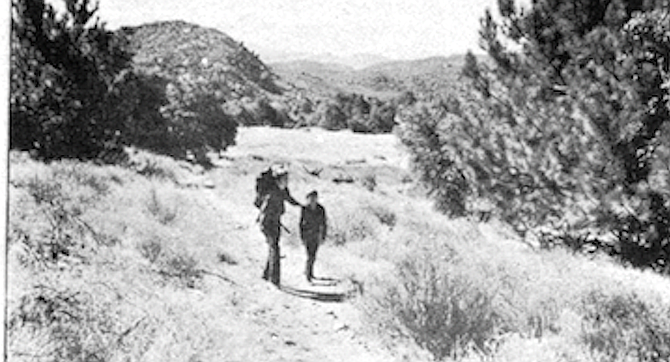
Hardly anyone moves to San Diego because of its back country. Anyone who is drawn here by nature moves here for the beaches. Or at least the temperate climate that nearness to the sea provides. But after a while, even the most devout sun worshipper grows weary of preening his tan. The allure of mountain pines and starry skies and clear dry air tempts any San Diegan after a while.
But why satisfy this temptation by packing hiking boots and Kelty backpack 6 or 7 or 10 hours away to the high or low Sierras? Why not take the opportunity to explore what is here in San Diego County, only one hour away?
CALIFORNIA RIDING AND HIKING
For the rugged, hubristic hero, who has already conquered, or is thinking of conquering, the John Muir Trail, there is the San Diego portion of the old California Riding and Hiking Trail. A nice 400 mile jaunt from just east of Chula Vista’s Otay Reservoir all the way to just north of Warner Springs in the Anza Borrego Desert. The Trail, commissioned by the State twenty years ago, is mostly dirt road and has been largely abandoned in deference to the highly-touted, not-yet-finished Pacific Crest Trail to the east.
The Riding and Hiking Trail suffers the disadvantage of its flammable flora (no fires allowed anywhere but designated campgrounds) and the obstacles of so many parcels of private property to cross. But if one plans his way out, the entire Trail could make an invigorating 30-day vacation.
THE PACIFIC CREST TRAIL
The Pacific Crest Trail has enjoyed the publicity of a full feature story in National Geographic as well as several articles in San Diego mass media. And perhaps rightly so. When the Trail is completed (by the end of 1975, say its builders), it will be a properly marked and pruned hiking trail, winding its way from Tecate, along the scenic mountain crests of the Pacific Coast the entire length of the state. Here, on the San Diego County portion, progress moves steadily on. For those who are anxious to try out the Trail’s finished sections, a 10-mile piece in the eastern end of Cleveland National Forest, running from Pioneer Mail Campground (about three miles northwest of Mt. Laguna) south to Horse Meadows, has just been completed. The Laguna Rim portion of the Trail (near Mt. Laguna) is done but for some final pruning. And a section from Yellow Rose Springs up to Cibbets Flats (directly south of Mt. Laguna) will be ready by this December. For more information on the Pacific Coast Trail, call the Cleveland National Forest at 293-5050.
SUGGESTED BACK PACKS
For the person who still considers himself a rugged individualist but is not adventurous enough to try the whole Riding and Hiking Trail or test the unfinished Pacific Crest Trail, there is the list of 2— or 3— day backpacks, mostly on parts of the Riding and Hiking Trail, suggested by the Boy Scouts:
15 Mile Round Trip
From Los Caballos Public campground to Arroyo Seco primitive camp and return— both in the Cuyamaca Rancho State Park (15 miles).
From Trail crossing at Sunrise Highway (S-l) to Banner Store private campground and return— just north of Cuyamaca State Park (18.6 miles).
Catholic Mission Church about 1/2 mile north of Warner Springs to Indian Flats U.S. Forest Service public campground and return (16.8 miles).
30 Mile Round Trip
Old Mission Church in Viejas Indian Reservation to - Arroyo Seco Primitive Camp and return (33.8 miles).
Hual-Cu-Cuish Boy Scout campground in Cuyamaca State Park to Banner Store private campground and return (30.0 miles).
Junction of San Felipe (S-2) and Montezuma (S-3) Roads to Indian Flats U.S. Forest Service public campgrounds and return (33.4 miles).
DAY HIKES
The soft-core hiker need not despair at the foregoing list of backpacks. There are, in fact, even more trails for the one-day hiker:
Cleveland National Forest— Descanso District
- The Horsethief Trail begins at Japatul Station (turn right on Los Torrientos turn-off from 1-80 just before Descanso Junction going east. Japatul is 6 miles south of turn-off). Horsethief leads up to the Espinosa Trail, which leads up to Corte Madera Mountain (4657 feet). 5 mile hike.
- The Corte Madera Trail goes down the mountain across Oak Valley to Pine Creek Campgrounds about 5 miles past Descanso on Highway 80. 7 mile hike.
- Noble Canyon Trail leaves the Pine Creek dirt road just about a mile above the Pine Creek campground, follows the creek up Noble Canyon, through some very pretty cedar, pine and oak, and comes out on the Laguna Meadow Road northwest of Mt. Laguna. 2 1/2 mile hike.
- There are four nature trails in the vicinity of Mt. Laguna. The Witch’s Broom Trail, which starts about Vi mile southwest of the Pioneer Mail Picnic Ground on the road up from Mt. Laguna, takes about 30 minutes to hike, and has some excellent examples of dwarf mistletoe. The Indian Loop Trail, which, goes through some Indian land, takes about 30 minutes. The Desert View Nature Trail, which leaves from the Burnt Rancherita Camp Gounds, takes about one hour. And the Wooded Hill guided nature trail south of Mt. Laguna, takes about an hour. All these are perfectly suited for the visitor to Mt. Laguna who only wants to see if his Lowa boots are going to give him blisters on a longer hike. Call the Descanso District of Cleveland National Forest for more information, 445-2211.
Cleveland National Forest— Palomar District
- The Agua Tibia Wilderness Trail begins at Dripping Springs Station (on Highway 71 east of Temecula) and .moves from chaparral at Dripping Springs to conifer on the top of Agua Tibia Mountain (4600 feet high). Water is limited along the trail, and the area is closed from about July 1 to about December 1 (call Palomar District, 745-2421, for exact closing and opening dates). 7 mile hike.
- Palomar Observatory Trails. One can hike up from Palomar Mountain Campgrounds, where there are 42 spaces for tents, trailers, or campers, and it costs $2 per night to stay. This trail is two miles long, and there is a brochure at the start of the Trail explaining the Trail’s ecology. One can also hike up the mountain from the Fry Creek Campgrounds, where there are 20 spaces for camping. According to plans, a one-mile guided nature trail should be ready next Spring.
- Indian Flats Trails. Just west of Warner Hot Springs on Highway 79, between the Lost Valley Road and the Agua Caliente Creek begins a portion of the Pacific Crest Trail which runs up to Indian Flats Campground. There is water in the Creek, there are 17 places in the Campground, and the fee for staying at Indian Flats is only $1 per night. 4 mile hike.
Cuyamaca Rancho State Park
Cuyamaca is probably the most accessible of all the trail areas. The turn-off for the State Park is on Interstate 8, 12 miles east of El Cajon (Highway 79 north). At the Green Valley Campground, about 2 miles beyond the turn-off, you can get a small map for free from the access ranger. This map outlines the miles and miles of trails, firebreaks, and primitive roads in Cuyamaca. Here are four favorites:
- Pine Ridge Trail is the favorite of the Green Valley access ranger, he says, because it has the best view looking down on the valley as you climb up. It leaves from the Green Valley station and goes up and connects with the Riding and Hiking Trail. XVi mile hike.
- Cuyamaca Peak Trail climbs up through a forest of oaks, pines, and firs, past Deer Spring to the 6,512-foot Cuyamaca Peak. The view, say the brochures, stretches out to the Pacific Ocean, to Mexico, and to the Salton Sea. 3V£ mile hike.
- The Stonewall Peak Trail winds up to the top of Stonewall Peak (5730 feet), overlooking the old Stonewall Mine, the old village site of Cuyamaca, and the desert slopes to the east. 2 mile hike.
- The Paso Nature Trail is a short, 30-minute trail which leaves from Paso Pichaco campground. It is a guided nature trail (brochures are available at the start of the trail).
If interested in making camp at Cuyamaca in order to hike out from camp, one has to either reserve space far in advance with Ticketron or else arrive Friday morning before the weekend. The campgrounds are almost always full on weekends year-round. There is no camping allowed on the Cuyamaca trails, and dogs aren’t allowed because their scent scares away the deer.
Here's something you might be interested in.
1974 San Diego guide to hiking trails
Calif. Riding and Hiking, Pacific Crest, and others
1974 San Diego guide to hiking trails
Calif. Riding and Hiking, Pacific Crest, and others
Cuyamaca is probably the most accessible of all the trail areas.
Hardly anyone moves to San Diego because of its back country. Anyone who is drawn here by nature moves here for the beaches. Or at least the temperate climate that nearness to the sea provides. But after a while, even the most devout sun worshipper grows weary of preening his tan. The allure of mountain pines and starry skies and clear dry air tempts any San Diegan after a while.
But why satisfy this temptation by packing hiking boots and Kelty backpack 6 or 7 or 10 hours away to the high or low Sierras? Why not take the opportunity to explore what is here in San Diego County, only one hour away?
CALIFORNIA RIDING AND HIKING
For the rugged, hubristic hero, who has already conquered, or is thinking of conquering, the John Muir Trail, there is the San Diego portion of the old California Riding and Hiking Trail. A nice 400 mile jaunt from just east of Chula Vista’s Otay Reservoir all the way to just north of Warner Springs in the Anza Borrego Desert. The Trail, commissioned by the State twenty years ago, is mostly dirt road and has been largely abandoned in deference to the highly-touted, not-yet-finished Pacific Crest Trail to the east.
The Riding and Hiking Trail suffers the disadvantage of its flammable flora (no fires allowed anywhere but designated campgrounds) and the obstacles of so many parcels of private property to cross. But if one plans his way out, the entire Trail could make an invigorating 30-day vacation.
THE PACIFIC CREST TRAIL
The Pacific Crest Trail has enjoyed the publicity of a full feature story in National Geographic as well as several articles in San Diego mass media. And perhaps rightly so. When the Trail is completed (by the end of 1975, say its builders), it will be a properly marked and pruned hiking trail, winding its way from Tecate, along the scenic mountain crests of the Pacific Coast the entire length of the state. Here, on the San Diego County portion, progress moves steadily on. For those who are anxious to try out the Trail’s finished sections, a 10-mile piece in the eastern end of Cleveland National Forest, running from Pioneer Mail Campground (about three miles northwest of Mt. Laguna) south to Horse Meadows, has just been completed. The Laguna Rim portion of the Trail (near Mt. Laguna) is done but for some final pruning. And a section from Yellow Rose Springs up to Cibbets Flats (directly south of Mt. Laguna) will be ready by this December. For more information on the Pacific Coast Trail, call the Cleveland National Forest at 293-5050.
SUGGESTED BACK PACKS
For the person who still considers himself a rugged individualist but is not adventurous enough to try the whole Riding and Hiking Trail or test the unfinished Pacific Crest Trail, there is the list of 2— or 3— day backpacks, mostly on parts of the Riding and Hiking Trail, suggested by the Boy Scouts:
15 Mile Round Trip
From Los Caballos Public campground to Arroyo Seco primitive camp and return— both in the Cuyamaca Rancho State Park (15 miles).
From Trail crossing at Sunrise Highway (S-l) to Banner Store private campground and return— just north of Cuyamaca State Park (18.6 miles).
Catholic Mission Church about 1/2 mile north of Warner Springs to Indian Flats U.S. Forest Service public campground and return (16.8 miles).
30 Mile Round Trip
Old Mission Church in Viejas Indian Reservation to - Arroyo Seco Primitive Camp and return (33.8 miles).
Hual-Cu-Cuish Boy Scout campground in Cuyamaca State Park to Banner Store private campground and return (30.0 miles).
Junction of San Felipe (S-2) and Montezuma (S-3) Roads to Indian Flats U.S. Forest Service public campgrounds and return (33.4 miles).
DAY HIKES
The soft-core hiker need not despair at the foregoing list of backpacks. There are, in fact, even more trails for the one-day hiker:
Cleveland National Forest— Descanso District
- The Horsethief Trail begins at Japatul Station (turn right on Los Torrientos turn-off from 1-80 just before Descanso Junction going east. Japatul is 6 miles south of turn-off). Horsethief leads up to the Espinosa Trail, which leads up to Corte Madera Mountain (4657 feet). 5 mile hike.
- The Corte Madera Trail goes down the mountain across Oak Valley to Pine Creek Campgrounds about 5 miles past Descanso on Highway 80. 7 mile hike.
- Noble Canyon Trail leaves the Pine Creek dirt road just about a mile above the Pine Creek campground, follows the creek up Noble Canyon, through some very pretty cedar, pine and oak, and comes out on the Laguna Meadow Road northwest of Mt. Laguna. 2 1/2 mile hike.
- There are four nature trails in the vicinity of Mt. Laguna. The Witch’s Broom Trail, which starts about Vi mile southwest of the Pioneer Mail Picnic Ground on the road up from Mt. Laguna, takes about 30 minutes to hike, and has some excellent examples of dwarf mistletoe. The Indian Loop Trail, which, goes through some Indian land, takes about 30 minutes. The Desert View Nature Trail, which leaves from the Burnt Rancherita Camp Gounds, takes about one hour. And the Wooded Hill guided nature trail south of Mt. Laguna, takes about an hour. All these are perfectly suited for the visitor to Mt. Laguna who only wants to see if his Lowa boots are going to give him blisters on a longer hike. Call the Descanso District of Cleveland National Forest for more information, 445-2211.
Cleveland National Forest— Palomar District
- The Agua Tibia Wilderness Trail begins at Dripping Springs Station (on Highway 71 east of Temecula) and .moves from chaparral at Dripping Springs to conifer on the top of Agua Tibia Mountain (4600 feet high). Water is limited along the trail, and the area is closed from about July 1 to about December 1 (call Palomar District, 745-2421, for exact closing and opening dates). 7 mile hike.
- Palomar Observatory Trails. One can hike up from Palomar Mountain Campgrounds, where there are 42 spaces for tents, trailers, or campers, and it costs $2 per night to stay. This trail is two miles long, and there is a brochure at the start of the Trail explaining the Trail’s ecology. One can also hike up the mountain from the Fry Creek Campgrounds, where there are 20 spaces for camping. According to plans, a one-mile guided nature trail should be ready next Spring.
- Indian Flats Trails. Just west of Warner Hot Springs on Highway 79, between the Lost Valley Road and the Agua Caliente Creek begins a portion of the Pacific Crest Trail which runs up to Indian Flats Campground. There is water in the Creek, there are 17 places in the Campground, and the fee for staying at Indian Flats is only $1 per night. 4 mile hike.
Cuyamaca Rancho State Park
Cuyamaca is probably the most accessible of all the trail areas. The turn-off for the State Park is on Interstate 8, 12 miles east of El Cajon (Highway 79 north). At the Green Valley Campground, about 2 miles beyond the turn-off, you can get a small map for free from the access ranger. This map outlines the miles and miles of trails, firebreaks, and primitive roads in Cuyamaca. Here are four favorites:
- Pine Ridge Trail is the favorite of the Green Valley access ranger, he says, because it has the best view looking down on the valley as you climb up. It leaves from the Green Valley station and goes up and connects with the Riding and Hiking Trail. XVi mile hike.
- Cuyamaca Peak Trail climbs up through a forest of oaks, pines, and firs, past Deer Spring to the 6,512-foot Cuyamaca Peak. The view, say the brochures, stretches out to the Pacific Ocean, to Mexico, and to the Salton Sea. 3V£ mile hike.
- The Stonewall Peak Trail winds up to the top of Stonewall Peak (5730 feet), overlooking the old Stonewall Mine, the old village site of Cuyamaca, and the desert slopes to the east. 2 mile hike.
- The Paso Nature Trail is a short, 30-minute trail which leaves from Paso Pichaco campground. It is a guided nature trail (brochures are available at the start of the trail).
If interested in making camp at Cuyamaca in order to hike out from camp, one has to either reserve space far in advance with Ticketron or else arrive Friday morning before the weekend. The campgrounds are almost always full on weekends year-round. There is no camping allowed on the Cuyamaca trails, and dogs aren’t allowed because their scent scares away the deer.
Comments