Here's something you might be interested in.
Ask a Hipster — Advice you didn't know you needed
Big Screen — Movie commentary
Blurt — Music's inside track
Booze News — San Diego spirits
Classical Music — Immortal beauty
Classifieds — Free and easy
Close to Home — What it’s like on the street where you live
Cover Stories — Front-page features
Drinks All Around — Bartenders' drink recipes
Excerpts — Literary and spiritual excerpts
Feast! — Food & drink reviews
Feature Stories — Local news & stories
Fishing Report — What’s getting hooked from ship and shore
From the Archives — Spotlight on the past
Golden Dreams — Talk of the town
The Gonzo Report — Making the musical scene, or at least reporting from it
Letters — Our inbox
Movies@Home — Local movie buffs share favorites
Movie Reviews — Our critics' picks and pans
Musician Interviews — Up close with local artists
Neighborhood News from Stringers — Hyperlocal news
News Ticker — News & politics
Obermeyer — San Diego politics illustrated
Outdoors — Weekly changes in flora and fauna
Overheard in San Diego — Eavesdropping illustrated
Poetry — The old and the new
Reader Travel — Travel section built by travelers
Reading — The hunt for intellectuals
Roam-O-Rama — SoCal's best hiking/biking trails
San Diego Beer — Inside San Diego suds
SD on the QT — Almost factual news
Sheep and Goats — Places of worship
Special Issues — The best of
Street Style — San Diego streets have style
Surf Diego — Real stories from those braving the waves
Theater — On stage in San Diego this week
Tin Fork — Silver spoon alternative
Under the Radar — Matt Potter's undercover work
Unforgettable — Long-ago San Diego
Unreal Estate — San Diego's priciest pads
Your Week — Daily event picks
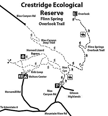
A chaparral oasis — Crestridge Ecological Reserve
Avoid the spur trails and give way to horses
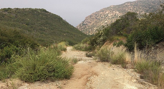
You will eventually reach the trail’s high point around a mile in, looking down into Flinn Springs County Park.
This is a relatively short out-and-back hike for those who want to find a trail with few people and that is easy to reach. The trail’s filled with many different chaparral flora and animals — several species of butterflies, lizards, and ants, in particular. Those looking for a longer hike and/or more strenuous activity can easily modify the route described here to add mileage and elevation challenges. Note that none of the trails or closed jeep roads are signed. The many user-made spur trails and the underutilization of this route can make it difficult to navigate if you are unfamiliar with the terrain. Note that there is only spotty cell-phone reception and no water.
Those looking for a longer hike and/or more strenuous activity can easily modify the route.
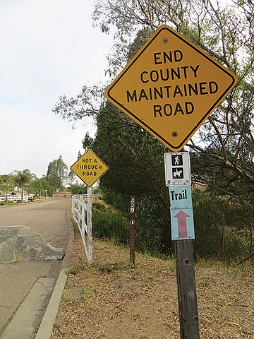
Park along Rios Canyon Road at the intersection of Gibson Highlands, then walk to the northeast corner of Rios Canyon Road and Gibson Highlands. The trail is marked below the “End County Maintained Road” sign and to the right of the “Not a Through Road” sign where the path dips between two fences. It initially parallels Rios Canyon Road on the east (right) side as a horse path. Once over the horse gate, in about 100 feet, there is the dirt road (labeled online as “Rios Canyon Road”).; turning west on this road leads to many possible old jeep and foot trails that connect to the heart of Crestridge Ecological Reserve.
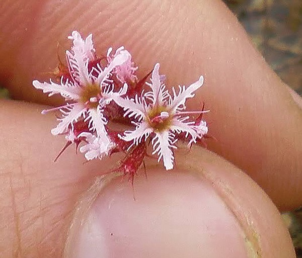
The fringed spineflower is native to California and mostly found only in San Diego and Baja.
The route described here instead turns to the east (right) and descends to another decommissioned jeep trail for approximately 660 feet before turning another right to the east. At 1000 feet, keep going east on the jeep road that runs parallel to power lines. Continue past two poles and their overgrown access trails, then ascend the trail to your left at about 1700 feet, or 0.32 mile.
The chaparral is dense and unforgiving, so it is best to stick to the main trail.
There are many user-made spur trails along this route that can be explored but they usually dead-end and the preference is to discontinue usage. The chaparral is dense and unforgiving, so it is best to stick to the main trail. You will eventually reach the trail’s high point around a mile in, looking down into Flinn Springs County Park. The trail down to the park is steep and badly eroded. If you are up for the hard climb back out, there are water and other facilities at the park. To return, retrace your route to the trailhead.
A trip here during May and through June 2017 during this higher-than-normal wet year revealed many different birds and more than 130 different plant species — a pleasant surprise for such a relatively short route. On the trail, you will find the typical native chaparral plants such as toyon, chamise, laurel sumac, broom baccharis, and buckwheat; you will also spot the ubiquitous nonnatives such as black mustard, horehound, fountain grass, tecolote, and filarees. However, there are numerous less-common native inhabitants as well: wide-throated monkeyflower, false mustard, hybrid white/black sage, bush rue, and the rare and purple-flowered Lakeside ceanothus. These latter plants are very noticeable, but just as interesting are the often-overlooked (literally) ankle-high examples of flora such as osmadenia/three-spot, hooked skunkweed (so named for its aroma), and fringed spineflower (Chorizanthe fimbriata). This latter annual herb is native to California and mostly found only in San Diego and Baja. It is among a group of plants in the Buckwheat family known as “spineflowers,” which have adapted to a wide range of environments. The leaves of this particular species are in a basal rosette with upper branches leafless, but having small spiny bracts (leaf-like structures underneath the flower). Here is a chaparral plant worth stooping down to see. Part of the common name of this plant is “fringed” because each of the six white to pink colored petals are ornately decorated with very noticeable fringed edges. If these flowers were three inches in diameter, they would be proudly on display in gardens throughout the world.
For those interested in geology, the surface rock formation shows considerable variation with many different types of granodiorites, metamorphosed sandstones, and large quartz outcroppings.
Note: Horses have the absolute right-of-way, followed by hikers. Trail etiquette for hikers is to stay on one side of the trail and not make sudden moves while the horseback riders pass.
Distance from downtown San Diego: 25 miles (El Cajon). From SR-163N, merge onto I-8E; exit south on Greenfield Drive and go for 0.5 mile. Turn left on La Cresta Road, go for 3.1 miles. Turn left onto Mountain View Road, go 1.4 miles. Take left on Rios Canyon Road, go for 0.4 mile. Park along the street south of the corner at Rios Canyon Road and Gibson Highlands.
Facilities: None. Dogs on leashes allowed.
Hiking length: 2 miles.
Difficulty: Easy with 300 feet elevation gain/loss.
Here's something you might be interested in.
A chaparral oasis — Crestridge Ecological Reserve
Avoid the spur trails and give way to horses
A chaparral oasis — Crestridge Ecological Reserve
Avoid the spur trails and give way to horses
You will eventually reach the trail’s high point around a mile in, looking down into Flinn Springs County Park.
This is a relatively short out-and-back hike for those who want to find a trail with few people and that is easy to reach. The trail’s filled with many different chaparral flora and animals — several species of butterflies, lizards, and ants, in particular. Those looking for a longer hike and/or more strenuous activity can easily modify the route described here to add mileage and elevation challenges. Note that none of the trails or closed jeep roads are signed. The many user-made spur trails and the underutilization of this route can make it difficult to navigate if you are unfamiliar with the terrain. Note that there is only spotty cell-phone reception and no water.
Those looking for a longer hike and/or more strenuous activity can easily modify the route.
Park along Rios Canyon Road at the intersection of Gibson Highlands, then walk to the northeast corner of Rios Canyon Road and Gibson Highlands. The trail is marked below the “End County Maintained Road” sign and to the right of the “Not a Through Road” sign where the path dips between two fences. It initially parallels Rios Canyon Road on the east (right) side as a horse path. Once over the horse gate, in about 100 feet, there is the dirt road (labeled online as “Rios Canyon Road”).; turning west on this road leads to many possible old jeep and foot trails that connect to the heart of Crestridge Ecological Reserve.
The fringed spineflower is native to California and mostly found only in San Diego and Baja.
The route described here instead turns to the east (right) and descends to another decommissioned jeep trail for approximately 660 feet before turning another right to the east. At 1000 feet, keep going east on the jeep road that runs parallel to power lines. Continue past two poles and their overgrown access trails, then ascend the trail to your left at about 1700 feet, or 0.32 mile.
The chaparral is dense and unforgiving, so it is best to stick to the main trail.
There are many user-made spur trails along this route that can be explored but they usually dead-end and the preference is to discontinue usage. The chaparral is dense and unforgiving, so it is best to stick to the main trail. You will eventually reach the trail’s high point around a mile in, looking down into Flinn Springs County Park. The trail down to the park is steep and badly eroded. If you are up for the hard climb back out, there are water and other facilities at the park. To return, retrace your route to the trailhead.
A trip here during May and through June 2017 during this higher-than-normal wet year revealed many different birds and more than 130 different plant species — a pleasant surprise for such a relatively short route. On the trail, you will find the typical native chaparral plants such as toyon, chamise, laurel sumac, broom baccharis, and buckwheat; you will also spot the ubiquitous nonnatives such as black mustard, horehound, fountain grass, tecolote, and filarees. However, there are numerous less-common native inhabitants as well: wide-throated monkeyflower, false mustard, hybrid white/black sage, bush rue, and the rare and purple-flowered Lakeside ceanothus. These latter plants are very noticeable, but just as interesting are the often-overlooked (literally) ankle-high examples of flora such as osmadenia/three-spot, hooked skunkweed (so named for its aroma), and fringed spineflower (Chorizanthe fimbriata). This latter annual herb is native to California and mostly found only in San Diego and Baja. It is among a group of plants in the Buckwheat family known as “spineflowers,” which have adapted to a wide range of environments. The leaves of this particular species are in a basal rosette with upper branches leafless, but having small spiny bracts (leaf-like structures underneath the flower). Here is a chaparral plant worth stooping down to see. Part of the common name of this plant is “fringed” because each of the six white to pink colored petals are ornately decorated with very noticeable fringed edges. If these flowers were three inches in diameter, they would be proudly on display in gardens throughout the world.
For those interested in geology, the surface rock formation shows considerable variation with many different types of granodiorites, metamorphosed sandstones, and large quartz outcroppings.
Note: Horses have the absolute right-of-way, followed by hikers. Trail etiquette for hikers is to stay on one side of the trail and not make sudden moves while the horseback riders pass.
Distance from downtown San Diego: 25 miles (El Cajon). From SR-163N, merge onto I-8E; exit south on Greenfield Drive and go for 0.5 mile. Turn left on La Cresta Road, go for 3.1 miles. Turn left onto Mountain View Road, go 1.4 miles. Take left on Rios Canyon Road, go for 0.4 mile. Park along the street south of the corner at Rios Canyon Road and Gibson Highlands.
Facilities: None. Dogs on leashes allowed.
Hiking length: 2 miles.
Difficulty: Easy with 300 feet elevation gain/loss.
Comments