Here's something you might be interested in.
Ask a Hipster — Advice you didn't know you needed
Big Screen — Movie commentary
Blurt — Music's inside track
Booze News — San Diego spirits
Classical Music — Immortal beauty
Classifieds — Free and easy
Close to Home — What it’s like on the street where you live
Cover Stories — Front-page features
Drinks All Around — Bartenders' drink recipes
Excerpts — Literary and spiritual excerpts
Feast! — Food & drink reviews
Feature Stories — Local news & stories
Fishing Report — What’s getting hooked from ship and shore
From the Archives — Spotlight on the past
Golden Dreams — Talk of the town
The Gonzo Report — Making the musical scene, or at least reporting from it
Letters — Our inbox
Movies@Home — Local movie buffs share favorites
Movie Reviews — Our critics' picks and pans
Musician Interviews — Up close with local artists
Neighborhood News from Stringers — Hyperlocal news
News Ticker — News & politics
Obermeyer — San Diego politics illustrated
Outdoors — Weekly changes in flora and fauna
Overheard in San Diego — Eavesdropping illustrated
Poetry — The old and the new
Reader Travel — Travel section built by travelers
Reading — The hunt for intellectuals
Roam-O-Rama — SoCal's best hiking/biking trails
San Diego Beer — Inside San Diego suds
SD on the QT — Almost factual news
Sheep and Goats — Places of worship
Special Issues — The best of
Street Style — San Diego streets have style
Surf Diego — Real stories from those braving the waves
Theater — On stage in San Diego this week
Tin Fork — Silver spoon alternative
Under the Radar — Matt Potter's undercover work
Unforgettable — Long-ago San Diego
Unreal Estate — San Diego's priciest pads
Your Week — Daily event picks
Beer mapping Sorrento Valley
"It's not like I have to pick which community's football team I need to support."
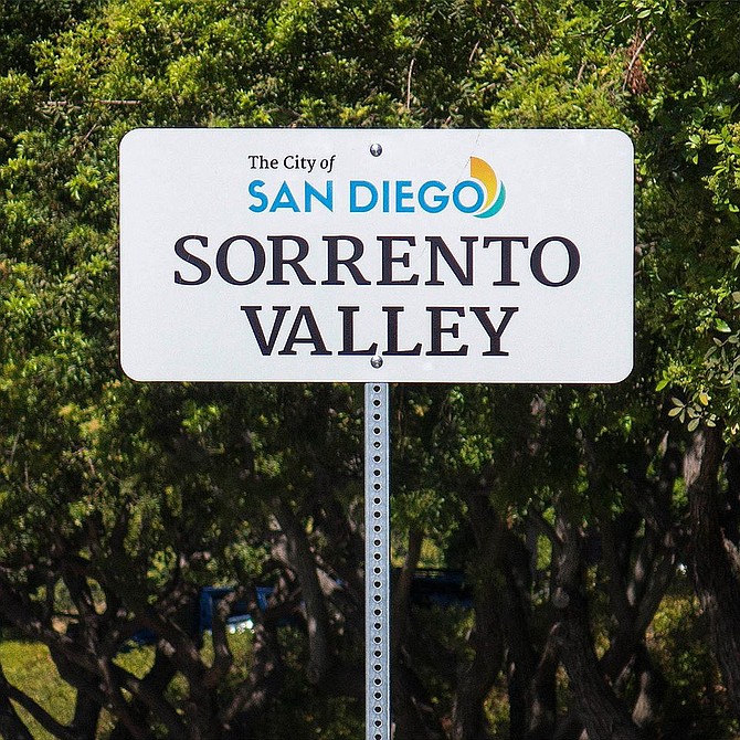
The city's new neighborhood signs extend Sorrento Valley east to Camino de Santa Fe.
In September, Sorrento Valley got new neighborhood signs from the city. Three signs mark the western Sorrento border along the 805 freeway. The fourth designates a northeastern border, on Calle Cristobal, just east of Camino Santa Fe.
Thing is, several breweries often reported as Mira Mesa breweries are actually west of Camino Santa Fe. If that's the border, these are actually Sorrento Valley breweries, and there are no breweries in Mira Mesa.
That includes Green Flash. Back in 2011, the onetime Vista brewery moved to a substantially bigger brewhouse on Mira Mesa Boulevard. Given the street address, both Green Flash and beer publications have dubbed it a Mira Mesa brewery. "An oversight, maybe," says a representative of Green Flash, noting it has no impact on doing business. "It doesn’t make a difference for any reason that we know of!"
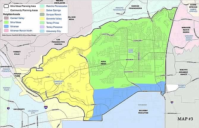
A city map shows borders of both the Mira Mesa community planning area and neighborhood boundaries for Sorrento Valley and Miramar.
Sorrento Valley's Town Council website includes Green Flash on its list of neighborhood breweries. Town council president Julia Schriber points out that neighborhood boundaries are loosely determined by public perception; however, "There is a policy in the City of San Diego that the police determines the boundaries of the neighborhoods." Sure enough, the police map shows Camino Santa Fe as the borderline.
That boundary extends south to Miramar Road, which also technically puts Rough Draft Brewing on the Sorrento Valley side. It's also listed on the Sorrento Valley website, along with known Sorrento breweries New English and Karl Strauss, plus Miramar's Saint Archer. The site hasn't been updated to add the recently opened Longship Brewery, located just two blocks south of Green Flash.
Rough Draft president Jeff Silver was amused to discover his brewery technically resides in Sorrento Valley, but also notes it makes no difference, business-wise. "I would still consider [Rough Draft] in Miramar," he says, joking, "It's not like I have to pick which community's football team I need to support."
Meanwhile, Saint Archer does officially remain within the western border of Miramar, though the boundaries are no less murky at that neighborhood's east end. Vista's Barrel Harbor Brewing has plans to open a tasting room at 8990 Miramar Road in October, and owner Tim St. Martin notes the new tasting room has a Mira Mesa zip code. However, the police map shows everything south of Carroll Canyon Road as Miramar. So Intergalactic Brewing, also sometimes reported as a Mira Mesa brewery, is in Miramar, as are all the breweries located on Miralani Drive — though just barely.
Schriber explains that Sorrento Valley, Mira Mesa and Miramar all fall within the general Mira Mesa planning area, leading to confusion and contention in recent community meetings.
Mira Mesa town council president Ted Brengel contends the confusion stems from people living in the west-of-Camino-Santa-Fe Lopez Ridge. He says they claim Sorrento Valley, "to distance the portion of the community in which they live from the demographically undesirable rest of Mira Mesa." He calls that sub-neighborhood Sorrento Mesa, and adds "I consider Green Flash a Mira Mesa brewery along with all the others that are within the boundaries of the Mira Mesa Community Plan."
So, depending which map they follow, breweries in both Beeramar and the sneakily active Sorrento Valley beer scene can always call themselves Mira Mesa breweries instead.
Here's something you might be interested in.
Beer mapping Sorrento Valley
"It's not like I have to pick which community's football team I need to support."
Beer mapping Sorrento Valley
"It's not like I have to pick which community's football team I need to support."
The city's new neighborhood signs extend Sorrento Valley east to Camino de Santa Fe.
In September, Sorrento Valley got new neighborhood signs from the city. Three signs mark the western Sorrento border along the 805 freeway. The fourth designates a northeastern border, on Calle Cristobal, just east of Camino Santa Fe.
Thing is, several breweries often reported as Mira Mesa breweries are actually west of Camino Santa Fe. If that's the border, these are actually Sorrento Valley breweries, and there are no breweries in Mira Mesa.
That includes Green Flash. Back in 2011, the onetime Vista brewery moved to a substantially bigger brewhouse on Mira Mesa Boulevard. Given the street address, both Green Flash and beer publications have dubbed it a Mira Mesa brewery. "An oversight, maybe," says a representative of Green Flash, noting it has no impact on doing business. "It doesn’t make a difference for any reason that we know of!"
A city map shows borders of both the Mira Mesa community planning area and neighborhood boundaries for Sorrento Valley and Miramar.
Sorrento Valley's Town Council website includes Green Flash on its list of neighborhood breweries. Town council president Julia Schriber points out that neighborhood boundaries are loosely determined by public perception; however, "There is a policy in the City of San Diego that the police determines the boundaries of the neighborhoods." Sure enough, the police map shows Camino Santa Fe as the borderline.
That boundary extends south to Miramar Road, which also technically puts Rough Draft Brewing on the Sorrento Valley side. It's also listed on the Sorrento Valley website, along with known Sorrento breweries New English and Karl Strauss, plus Miramar's Saint Archer. The site hasn't been updated to add the recently opened Longship Brewery, located just two blocks south of Green Flash.
Rough Draft president Jeff Silver was amused to discover his brewery technically resides in Sorrento Valley, but also notes it makes no difference, business-wise. "I would still consider [Rough Draft] in Miramar," he says, joking, "It's not like I have to pick which community's football team I need to support."
Meanwhile, Saint Archer does officially remain within the western border of Miramar, though the boundaries are no less murky at that neighborhood's east end. Vista's Barrel Harbor Brewing has plans to open a tasting room at 8990 Miramar Road in October, and owner Tim St. Martin notes the new tasting room has a Mira Mesa zip code. However, the police map shows everything south of Carroll Canyon Road as Miramar. So Intergalactic Brewing, also sometimes reported as a Mira Mesa brewery, is in Miramar, as are all the breweries located on Miralani Drive — though just barely.
Schriber explains that Sorrento Valley, Mira Mesa and Miramar all fall within the general Mira Mesa planning area, leading to confusion and contention in recent community meetings.
Mira Mesa town council president Ted Brengel contends the confusion stems from people living in the west-of-Camino-Santa-Fe Lopez Ridge. He says they claim Sorrento Valley, "to distance the portion of the community in which they live from the demographically undesirable rest of Mira Mesa." He calls that sub-neighborhood Sorrento Mesa, and adds "I consider Green Flash a Mira Mesa brewery along with all the others that are within the boundaries of the Mira Mesa Community Plan."
So, depending which map they follow, breweries in both Beeramar and the sneakily active Sorrento Valley beer scene can always call themselves Mira Mesa breweries instead.
Comments