Here's something you might be interested in.
Ask a Hipster — Advice you didn't know you needed
Big Screen — Movie commentary
Blurt — Music's inside track
Booze News — San Diego spirits
Classical Music — Immortal beauty
Classifieds — Free and easy
Close to Home — What it’s like on the street where you live
Cover Stories — Front-page features
Drinks All Around — Bartenders' drink recipes
Excerpts — Literary and spiritual excerpts
Feast! — Food & drink reviews
Feature Stories — Local news & stories
Fishing Report — What’s getting hooked from ship and shore
From the Archives — Spotlight on the past
Golden Dreams — Talk of the town
The Gonzo Report — Making the musical scene, or at least reporting from it
Letters — Our inbox
Movies@Home — Local movie buffs share favorites
Movie Reviews — Our critics' picks and pans
Musician Interviews — Up close with local artists
Neighborhood News from Stringers — Hyperlocal news
News Ticker — News & politics
Obermeyer — San Diego politics illustrated
Outdoors — Weekly changes in flora and fauna
Overheard in San Diego — Eavesdropping illustrated
Poetry — The old and the new
Reader Travel — Travel section built by travelers
Reading — The hunt for intellectuals
Roam-O-Rama — SoCal's best hiking/biking trails
San Diego Beer — Inside San Diego suds
SD on the QT — Almost factual news
Sheep and Goats — Places of worship
Special Issues — The best of
Street Style — San Diego streets have style
Surf Diego — Real stories from those braving the waves
Theater — On stage in San Diego this week
Tin Fork — Silver spoon alternative
Under the Radar — Matt Potter's undercover work
Unforgettable — Long-ago San Diego
Unreal Estate — San Diego's priciest pads
Your Week — Daily event picks
Best access to San Luis Rey River’s wild side
Experience a free-flowing river with the possibility of a cool dip.
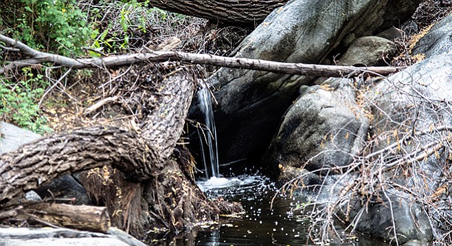
A small falls is near a downed tree.
There are relatively few places where the public has access to the San Luis Rey River in its native wild state. For most of its 55-mile length it has been extensively modified by flood-control projects, housing or shopping center developments, and intensive recreational use. One of the best places to experience this river in something approaching its wild state is in the U.S. Forest picnic area off highway 76 near Lake Henshaw. Here, dense riparian vegetation and huge moss-covered boulders line a free-flowing river, providing a habitat for birds and other wildlife. Not only is it a great place for birds, but it also is an excellent place for a family picnic and a hike along the river’s banks. If the conditions permit, you could even take a dip in the river’s cool waters.
The trail for the upstream hike begins on the left side of the information kiosk and continues for about 0.2 mile, passing through a dense forest of coast live oaks, California sycamores, Fremont cottonwoods, white alders, and black willows. It is the steady presence of water that makes this lush forest possible, but alders also contribute an important nutrient to this richness because their roots have nodules that fix gaseous nitrogen and convert it to a form that plants can utilize.
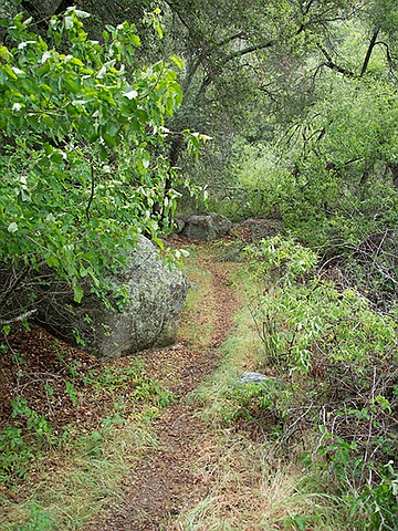
San Luis Rey trail heading upstream
In addition to the dense canopy of trees, there is an equally dense understory of arroyo willows, snowberry, California blackberry, wild rose, and, of course, poison oak. The poison oak can be quite beautiful with interesting small cream-colored berries during season. Their leaves are a brilliant green in the spring and turn a luminescent red in the fall. Don’t be deceived by its looks. If you are in the half of the population that is sensitive to the urushiol skin irritant that this plant contains, be extra vigilant.
This understory as well as the forest canopy supports an amazing variety of birds. These include such common species as Steller’s jay, black phoebe, the acorn woodpecker, plus several species of warblers and sparrows. Some birds are only found here in the summer — the neotropical migrants that fly to South or Central America to escape our “brutal” winters. These migrants include the yellow warbler, lazuli bunting, and the black-chinned hummingbird, as well as the willow flycatcher, an endangered species with only a few breeding pairs left.
Toward the end of the upstream trail, there is a swimming hole that could be enjoyed on hot summer days in years that have normal rainfall, but during drought years, it is only a place to get your ankles wet. The advantage of low water is that it is more apt to be quiet here, with fewer people frolicking in the stream. Sitting here in solitude will increase the number of birds seen and make it easier to listen to their songs.
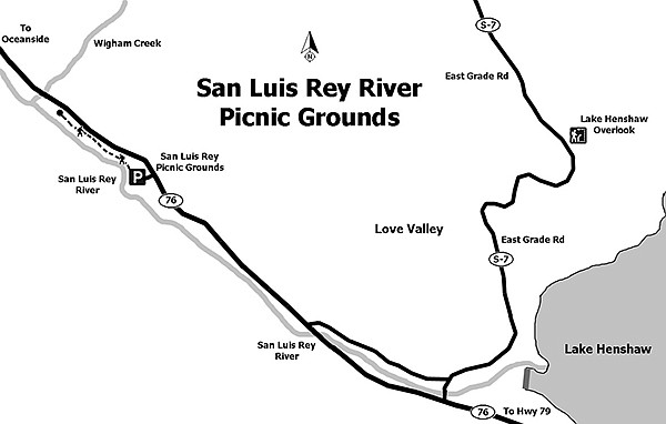
San Luis Rey River Picnic Grounds
Upon reaching the swimming hole, retrace your steps to return to the picnic area. However, the hike is not necessarily over. Walk to the opposite end of the road and find the last picnic table on a small rise that is between you and the river. Climb over the rise and down to the river where there is another swimming hole. Cross the river here and find another trail that will take you about 0.2 mile downstream, but don’t attempt to cross the stream if the water is high. The forest canopy is more open here and the understory is less dense, but the mossy boulders are a rewarding sight.
Note: Hiking further downstream enters private property. Although limited in hiking opportunities, it is a great place to learn about riparian habitats.
San Luis Rey River
Distance from downtown San Diego: 65 miles. Allow 1.5 hours driving time (Lake Henshaw). From the junction of SR-78 and SR-79 in Santa Ysabel, drive about 7 miles north on SR-79 to the junction with SR-76. Turn west (left) on SR-76 and drive 6.5 miles, past Lake Henshaw, to the U.S. Forest Service San Luis Rey Picnic Area. The entrance, on the left, is about 50 yards beyond the picnic-area sign.
Hiking Length: less than 1 mile.
Difficulty: Easy, less than 200 feet elevation gain/loss. U.S. Forest Service Adventure Pass required or pay a daily use fee per vehicle. Hours open: 8 a.m. to sunset daily. Bicycles and dogs (on leashes) allowed. Facilities and water.
Here's something you might be interested in.
Best access to San Luis Rey River’s wild side
Experience a free-flowing river with the possibility of a cool dip.
Best access to San Luis Rey River’s wild side
Experience a free-flowing river with the possibility of a cool dip.
A small falls is near a downed tree.
There are relatively few places where the public has access to the San Luis Rey River in its native wild state. For most of its 55-mile length it has been extensively modified by flood-control projects, housing or shopping center developments, and intensive recreational use. One of the best places to experience this river in something approaching its wild state is in the U.S. Forest picnic area off highway 76 near Lake Henshaw. Here, dense riparian vegetation and huge moss-covered boulders line a free-flowing river, providing a habitat for birds and other wildlife. Not only is it a great place for birds, but it also is an excellent place for a family picnic and a hike along the river’s banks. If the conditions permit, you could even take a dip in the river’s cool waters.
The trail for the upstream hike begins on the left side of the information kiosk and continues for about 0.2 mile, passing through a dense forest of coast live oaks, California sycamores, Fremont cottonwoods, white alders, and black willows. It is the steady presence of water that makes this lush forest possible, but alders also contribute an important nutrient to this richness because their roots have nodules that fix gaseous nitrogen and convert it to a form that plants can utilize.
San Luis Rey trail heading upstream
In addition to the dense canopy of trees, there is an equally dense understory of arroyo willows, snowberry, California blackberry, wild rose, and, of course, poison oak. The poison oak can be quite beautiful with interesting small cream-colored berries during season. Their leaves are a brilliant green in the spring and turn a luminescent red in the fall. Don’t be deceived by its looks. If you are in the half of the population that is sensitive to the urushiol skin irritant that this plant contains, be extra vigilant.
This understory as well as the forest canopy supports an amazing variety of birds. These include such common species as Steller’s jay, black phoebe, the acorn woodpecker, plus several species of warblers and sparrows. Some birds are only found here in the summer — the neotropical migrants that fly to South or Central America to escape our “brutal” winters. These migrants include the yellow warbler, lazuli bunting, and the black-chinned hummingbird, as well as the willow flycatcher, an endangered species with only a few breeding pairs left.
Toward the end of the upstream trail, there is a swimming hole that could be enjoyed on hot summer days in years that have normal rainfall, but during drought years, it is only a place to get your ankles wet. The advantage of low water is that it is more apt to be quiet here, with fewer people frolicking in the stream. Sitting here in solitude will increase the number of birds seen and make it easier to listen to their songs.
San Luis Rey River Picnic Grounds
Upon reaching the swimming hole, retrace your steps to return to the picnic area. However, the hike is not necessarily over. Walk to the opposite end of the road and find the last picnic table on a small rise that is between you and the river. Climb over the rise and down to the river where there is another swimming hole. Cross the river here and find another trail that will take you about 0.2 mile downstream, but don’t attempt to cross the stream if the water is high. The forest canopy is more open here and the understory is less dense, but the mossy boulders are a rewarding sight.
Note: Hiking further downstream enters private property. Although limited in hiking opportunities, it is a great place to learn about riparian habitats.
San Luis Rey River
Distance from downtown San Diego: 65 miles. Allow 1.5 hours driving time (Lake Henshaw). From the junction of SR-78 and SR-79 in Santa Ysabel, drive about 7 miles north on SR-79 to the junction with SR-76. Turn west (left) on SR-76 and drive 6.5 miles, past Lake Henshaw, to the U.S. Forest Service San Luis Rey Picnic Area. The entrance, on the left, is about 50 yards beyond the picnic-area sign.
Hiking Length: less than 1 mile.
Difficulty: Easy, less than 200 feet elevation gain/loss. U.S. Forest Service Adventure Pass required or pay a daily use fee per vehicle. Hours open: 8 a.m. to sunset daily. Bicycles and dogs (on leashes) allowed. Facilities and water.
Comments