Here's something you might be interested in.
Ask a Hipster — Advice you didn't know you needed
Big Screen — Movie commentary
Blurt — Music's inside track
Booze News — San Diego spirits
Classical Music — Immortal beauty
Classifieds — Free and easy
Close to Home — What it’s like on the street where you live
Cover Stories — Front-page features
Drinks All Around — Bartenders' drink recipes
Excerpts — Literary and spiritual excerpts
Feast! — Food & drink reviews
Feature Stories — Local news & stories
Fishing Report — What’s getting hooked from ship and shore
From the Archives — Spotlight on the past
Golden Dreams — Talk of the town
The Gonzo Report — Making the musical scene, or at least reporting from it
Letters — Our inbox
Movies@Home — Local movie buffs share favorites
Movie Reviews — Our critics' picks and pans
Musician Interviews — Up close with local artists
Neighborhood News from Stringers — Hyperlocal news
News Ticker — News & politics
Obermeyer — San Diego politics illustrated
Outdoors — Weekly changes in flora and fauna
Overheard in San Diego — Eavesdropping illustrated
Poetry — The old and the new
Reader Travel — Travel section built by travelers
Reading — The hunt for intellectuals
Roam-O-Rama — SoCal's best hiking/biking trails
San Diego Beer — Inside San Diego suds
SD on the QT — Almost factual news
Sheep and Goats — Places of worship
Special Issues — The best of
Street Style — San Diego streets have style
Surf Diego — Real stories from those braving the waves
Theater — On stage in San Diego this week
Tin Fork — Silver spoon alternative
Under the Radar — Matt Potter's undercover work
Unforgettable — Long-ago San Diego
Unreal Estate — San Diego's priciest pads
Your Week — Daily event picks
Flora, fauna, and folks on San Luis Rey River bike trail
A quiet ride along the river
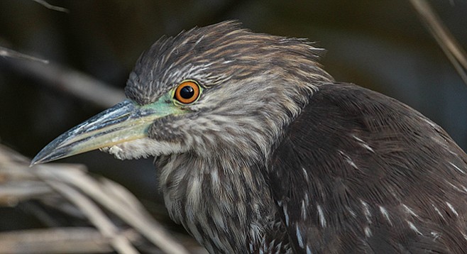
A juvenile night heron on the San Luis Rey River
The San Luis Rey River bike trail is a multi-use trail that follows the San Luis Rey River, whose headwaters are in the Palomar Mountain range some 60 miles inland. The path runs along the top of the flood-control levee built by the Army Corps of Engineers in the 1980s. Prior to paving the trail and it becoming the widely popular Class 1 bike route that it is today, it was used by the military as a private railway to move cargo along the river.
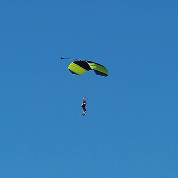
A sky diver near the Oceanside airport
Starting in downtown Oceanside, along Neptune Way, the western terminus puts visitors a short distance from the Oceanside Transit Center, giving commuters easy access to points across the county and beyond. Additionally, visitors can connect with the planned 44-mile Coastal Rail Trail that will eventually link Oceanside to downtown San Diego.
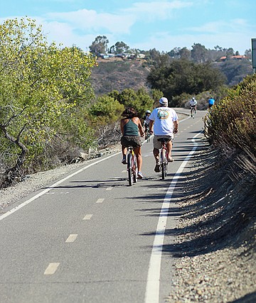
San Luis Rey River Trail bike riders
The San Luis Rey River bike trail is a great opportunity to get outside for an extended bike ride, run, or just a brisk walk and see areas that are often hidden from the street. The west end of the trail begins at the beach and takes visitors along the river inland, offering up-close encounters with native plants, insects, and birds inhabiting the riparian zone. Common plant species include western sycamore, arroyo willow, cordgrass, and narrow-leaf cattail. Along with the native plants, this section is a great spot for bird watching, as many of the lagoons and rivers along Southern California’s coast are part of the Pacific Flyway. Birds commonly seen along the San Luis Rey include snowy egrets, blue herons, grebes, and various ducks.
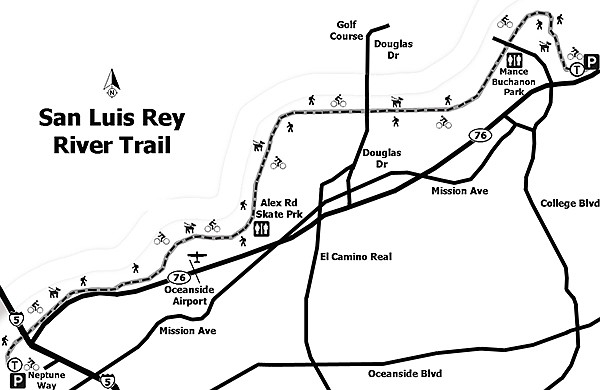
San Luis Rey River Trail map
The trail, designed with commuters in mind, is an easy-to-follow pathway; however, many sections do not have after-hours lighting and use after sunset is discouraged. As the trail takes visitors through various Oceanside neighborhoods, access to restrooms and water are available at stores and fast-food places off the trail. However, the two best spots along the trail to take a break with facilities are at the Alex Road Skate Park and Mance Buchanan Park.
Near Foussat Road and the Oceanside municipal airport is the Alex Road Skate Park. This park is open for skateboarding during daylight hours, 365 days per year, for skaters of all ages. Visitors can stop to watch the amazing skateboard antics, stop for water, or use the facilities. Be sure to keep an eye skyward when near the airport, as the area is a popular skydiving location.
Continuing east, the trail brings visitors to Mance Buchanan Park, with its soccer fields and running track, and finally to the edge of Guajome Regional Park and the current end of the trail. The adventure needn’t end there, as future plans call for extending the trail east all the way to Escondido.
Canyoneers are San Diego Natural History Museum volunteers trained to lead interpretive nature walks that teach appreciation for the great outdoors. For a schedule of free public hikes, refer to the San Diego Natural History Museum website. Hike descriptions are also found in Coast to Cactus: The Canyoneer Trail Guide to San Diego Outdoors.
San Luis Rey Rive (Bike) Trail
Distance from downtown San Diego: Approximately 38 miles (Oceanside — west end; 54 miles east end). Allow 40 or 60 minutes driving time (west or east end). For the west trailhead, take I-5 north for 37 miles to Oceanside and exit onto Hwy 76, heading west toward the beach. Merge onto North Coast Hwy, turning south to connect to Neptune Way. (Parking is allowable where indicated along the street or in the parking lots near Oceanside Harbor.) Alternatively, for the east trailhead, take I-5 north for 47 miles to Oceanside, exit onto Hwy 76 heading east (toward Escondido) for approximately 7.5 miles. At the intersection of North Santa Fe Drive and Hwy 76 (Mission Ave.), turn left (north). Parking is available in the gravel parking lot or along the street.
Hiking length: Approximately 9 miles from Neptune Way (west end) in downtown Oceanside to N. Santa Fe Drive (east end). This makes an 18-mile round-trip by bicycle.
Difficulty: Easy with approximately 50 feet elevation gain/loss. Dogs are allowed on leashes less than 6 ft. However, neither equestrian nor motorized traffic is allowed along the trail. There are facilities at the Alex Road Skate Park and Mance Buchanan Park. Information kiosks at the western and eastern ends of the trail are available to provide users with trail maps and to denote points of interest.
Here's something you might be interested in.
Flora, fauna, and folks on San Luis Rey River bike trail
A quiet ride along the river
Flora, fauna, and folks on San Luis Rey River bike trail
A quiet ride along the river
A juvenile night heron on the San Luis Rey River
The San Luis Rey River bike trail is a multi-use trail that follows the San Luis Rey River, whose headwaters are in the Palomar Mountain range some 60 miles inland. The path runs along the top of the flood-control levee built by the Army Corps of Engineers in the 1980s. Prior to paving the trail and it becoming the widely popular Class 1 bike route that it is today, it was used by the military as a private railway to move cargo along the river.
A sky diver near the Oceanside airport
Starting in downtown Oceanside, along Neptune Way, the western terminus puts visitors a short distance from the Oceanside Transit Center, giving commuters easy access to points across the county and beyond. Additionally, visitors can connect with the planned 44-mile Coastal Rail Trail that will eventually link Oceanside to downtown San Diego.
San Luis Rey River Trail bike riders
The San Luis Rey River bike trail is a great opportunity to get outside for an extended bike ride, run, or just a brisk walk and see areas that are often hidden from the street. The west end of the trail begins at the beach and takes visitors along the river inland, offering up-close encounters with native plants, insects, and birds inhabiting the riparian zone. Common plant species include western sycamore, arroyo willow, cordgrass, and narrow-leaf cattail. Along with the native plants, this section is a great spot for bird watching, as many of the lagoons and rivers along Southern California’s coast are part of the Pacific Flyway. Birds commonly seen along the San Luis Rey include snowy egrets, blue herons, grebes, and various ducks.
San Luis Rey River Trail map
The trail, designed with commuters in mind, is an easy-to-follow pathway; however, many sections do not have after-hours lighting and use after sunset is discouraged. As the trail takes visitors through various Oceanside neighborhoods, access to restrooms and water are available at stores and fast-food places off the trail. However, the two best spots along the trail to take a break with facilities are at the Alex Road Skate Park and Mance Buchanan Park.
Near Foussat Road and the Oceanside municipal airport is the Alex Road Skate Park. This park is open for skateboarding during daylight hours, 365 days per year, for skaters of all ages. Visitors can stop to watch the amazing skateboard antics, stop for water, or use the facilities. Be sure to keep an eye skyward when near the airport, as the area is a popular skydiving location.
Continuing east, the trail brings visitors to Mance Buchanan Park, with its soccer fields and running track, and finally to the edge of Guajome Regional Park and the current end of the trail. The adventure needn’t end there, as future plans call for extending the trail east all the way to Escondido.
Canyoneers are San Diego Natural History Museum volunteers trained to lead interpretive nature walks that teach appreciation for the great outdoors. For a schedule of free public hikes, refer to the San Diego Natural History Museum website. Hike descriptions are also found in Coast to Cactus: The Canyoneer Trail Guide to San Diego Outdoors.
San Luis Rey Rive (Bike) Trail
Distance from downtown San Diego: Approximately 38 miles (Oceanside — west end; 54 miles east end). Allow 40 or 60 minutes driving time (west or east end). For the west trailhead, take I-5 north for 37 miles to Oceanside and exit onto Hwy 76, heading west toward the beach. Merge onto North Coast Hwy, turning south to connect to Neptune Way. (Parking is allowable where indicated along the street or in the parking lots near Oceanside Harbor.) Alternatively, for the east trailhead, take I-5 north for 47 miles to Oceanside, exit onto Hwy 76 heading east (toward Escondido) for approximately 7.5 miles. At the intersection of North Santa Fe Drive and Hwy 76 (Mission Ave.), turn left (north). Parking is available in the gravel parking lot or along the street.
Hiking length: Approximately 9 miles from Neptune Way (west end) in downtown Oceanside to N. Santa Fe Drive (east end). This makes an 18-mile round-trip by bicycle.
Difficulty: Easy with approximately 50 feet elevation gain/loss. Dogs are allowed on leashes less than 6 ft. However, neither equestrian nor motorized traffic is allowed along the trail. There are facilities at the Alex Road Skate Park and Mance Buchanan Park. Information kiosks at the western and eastern ends of the trail are available to provide users with trail maps and to denote points of interest.
Comments