Here's something you might be interested in.
Ask a Hipster — Advice you didn't know you needed
Big Screen — Movie commentary
Blurt — Music's inside track
Booze News — San Diego spirits
Classical Music — Immortal beauty
Classifieds — Free and easy
Close to Home — What it’s like on the street where you live
Cover Stories — Front-page features
Drinks All Around — Bartenders' drink recipes
Excerpts — Literary and spiritual excerpts
Feast! — Food & drink reviews
Feature Stories — Local news & stories
Fishing Report — What’s getting hooked from ship and shore
From the Archives — Spotlight on the past
Golden Dreams — Talk of the town
The Gonzo Report — Making the musical scene, or at least reporting from it
Letters — Our inbox
Movies@Home — Local movie buffs share favorites
Movie Reviews — Our critics' picks and pans
Musician Interviews — Up close with local artists
Neighborhood News from Stringers — Hyperlocal news
News Ticker — News & politics
Obermeyer — San Diego politics illustrated
Outdoors — Weekly changes in flora and fauna
Overheard in San Diego — Eavesdropping illustrated
Poetry — The old and the new
Reader Travel — Travel section built by travelers
Reading — The hunt for intellectuals
Roam-O-Rama — SoCal's best hiking/biking trails
San Diego Beer — Inside San Diego suds
SD on the QT — Almost factual news
Sheep and Goats — Places of worship
Special Issues — The best of
Street Style — San Diego streets have style
Surf Diego — Real stories from those braving the waves
Theater — On stage in San Diego this week
Tin Fork — Silver spoon alternative
Under the Radar — Matt Potter's undercover work
Unforgettable — Long-ago San Diego
Unreal Estate — San Diego's priciest pads
Your Week — Daily event picks
Hike in rolling grasslands in this scenic mountain preserve
Santa Ysabel Open Space Preserve is growing in size
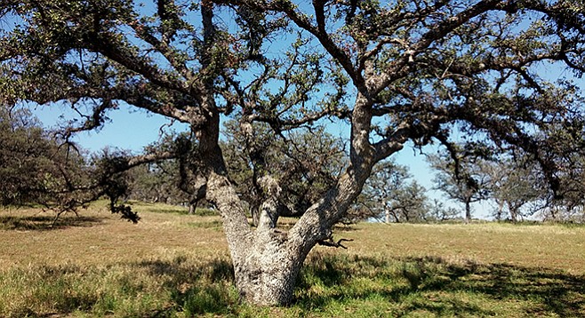
An old Engelmann oak sprawls out like a spider
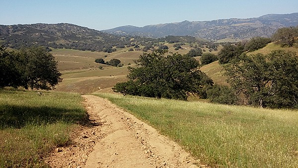
Looking north to the San Dieguito River
Santa Ysabel Open Space Preserve is within the San Dieguito River watershed that is the drainage area from the rivers’ headwaters in Volcan Mountain to the Pacific Ocean via the San Dieguito Lagoon in Del Mar. The land on both sides of SR-79, just north of Santa Ysabel, was acquired by the Nature Conservancy in 1999 to protect the habitats, including grasslands, riparian, chaparral, oak woodlands, and mountain meadows, for large animals such as deer and mountain lions.
In 2001, San Diego County’s Department of Parks and Recreation acquired 5322 acres to create both the East and West sections of the Santa Ysabel Open Space Preserve. Over the years, the acreage has grown, with the latest acquisition of another 175 acres in June 2015 that will connect the East and West sections for a total of 5881 acres. The preserve is part of the San Dieguito River Park and includes a portion of the 55-mile Coast to Crest Trail from Volcan Mountain to the San Dieguito Lagoon.
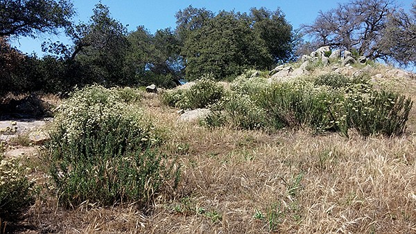
Buckwheat on the trail
Well before it became a preserve, the area was the home to Kumeyaay Indians. Mission San Diego de Alcalá established Santa Ysabel Asistencia in 1818 tend to the Indian community. The locale then became part of Rancho Santa Ysabel, an 1844 Mexican land grant that belonged to José Joaquín Ortega and Eduardo Stokes. The town site of Santa Ysabel is within the former rancho lands. The town began with a store owned by C.R. Wellington and later grew to include a hotel and blacksmith shop. By 1889, the town even had its own post office. The primary use of the preserve lands in those days was for cattle grazing, as it is today. Hikers may encounter free-range cattle during their exploration of preserve lands. Don’t approach young calves, as their mothers are very protective.
One of the key attractions of this hike is the preservation of these grazing lands that give a glimpse into the backcountry world of San Diego almost 200 years ago. The preserve has many oak trees; both Engelmann and coast live, surrounded by grasslands. Within the grasslands may be fields of flowers, especially in spring, with patches of white and black sage and other shrubs including chamise, coyote bush, and flattop buckwheat, accompanied by buzzing bees. Numerous bird species are also present. The expansive views are of the mountains in the distance where turkey vultures may be seen in the sky as they soar with their wings in a V-shape, often rocking from side-to-side. Another name for them is the “peace bird,” since they do not kill. They do not follow weak or dying animals, but they do follow the scent of animals that are already dead. They have poor eyesight, but their superior sense of smell can detect one drop of blood in an Olympic-sized pool. Thought to mate for life, they are social and non-aggressive.
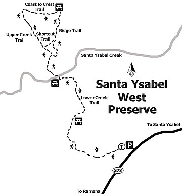
Santa Ysabel West Preserve
From the trailhead, follow the Lower Creek Trail 1.84 miles to a junction with the Upper Creek Trail and the Ridge Trail. This is a 1.87-mile loop, so either direction is fine. Both trails lead to the east-west connection with the Coast to Crest Trail. All trails are well-marked and signed. There is also a Shortcut Trail between the Ridge Trail and the Upper Creek Trail that can make another short loop. Santa Ysabel Creek runs along the northern boundary of the preserve near the Coast to Crest Trail.
Distance from downtown San Diego: 50 miles. Allow 1 hour driving time (Santa Ysabel). Take SR-163 N and exit at Scripps Poway Parkway. Turn right (east) and drive 8.6 miles to SR-67. Turn left (north) and continue 13 miles through Ramona to where SR-67 becomes SR-78. Go straight toward Santa Ysabel for about 12 miles. Parking is on the left where the trailhead is located.
Hiking length: About 6 miles out-and-back with a loop. Allow 4 hours.
Difficulty: Moderately difficult with steep, slippery sections through foothills. Elevation gain/loss less than 300 feet. No facilities or water. Dogs (on leashes) and mountain bikes allowed. Cattle roam freely in the preserve. Avoid high-temperature days. Fall and winter hours: 8 a.m.–5 p.m.; Spring and summer hours: 8 a.m.–7 p.m. with possibility of closure during inclement weather. Current status: 760-765-4098 or 760-814-0208.
Here's something you might be interested in.
Hike in rolling grasslands in this scenic mountain preserve
Santa Ysabel Open Space Preserve is growing in size
Hike in rolling grasslands in this scenic mountain preserve
Santa Ysabel Open Space Preserve is growing in size
An old Engelmann oak sprawls out like a spider
Looking north to the San Dieguito River
Santa Ysabel Open Space Preserve is within the San Dieguito River watershed that is the drainage area from the rivers’ headwaters in Volcan Mountain to the Pacific Ocean via the San Dieguito Lagoon in Del Mar. The land on both sides of SR-79, just north of Santa Ysabel, was acquired by the Nature Conservancy in 1999 to protect the habitats, including grasslands, riparian, chaparral, oak woodlands, and mountain meadows, for large animals such as deer and mountain lions.
In 2001, San Diego County’s Department of Parks and Recreation acquired 5322 acres to create both the East and West sections of the Santa Ysabel Open Space Preserve. Over the years, the acreage has grown, with the latest acquisition of another 175 acres in June 2015 that will connect the East and West sections for a total of 5881 acres. The preserve is part of the San Dieguito River Park and includes a portion of the 55-mile Coast to Crest Trail from Volcan Mountain to the San Dieguito Lagoon.
Buckwheat on the trail
Well before it became a preserve, the area was the home to Kumeyaay Indians. Mission San Diego de Alcalá established Santa Ysabel Asistencia in 1818 tend to the Indian community. The locale then became part of Rancho Santa Ysabel, an 1844 Mexican land grant that belonged to José Joaquín Ortega and Eduardo Stokes. The town site of Santa Ysabel is within the former rancho lands. The town began with a store owned by C.R. Wellington and later grew to include a hotel and blacksmith shop. By 1889, the town even had its own post office. The primary use of the preserve lands in those days was for cattle grazing, as it is today. Hikers may encounter free-range cattle during their exploration of preserve lands. Don’t approach young calves, as their mothers are very protective.
One of the key attractions of this hike is the preservation of these grazing lands that give a glimpse into the backcountry world of San Diego almost 200 years ago. The preserve has many oak trees; both Engelmann and coast live, surrounded by grasslands. Within the grasslands may be fields of flowers, especially in spring, with patches of white and black sage and other shrubs including chamise, coyote bush, and flattop buckwheat, accompanied by buzzing bees. Numerous bird species are also present. The expansive views are of the mountains in the distance where turkey vultures may be seen in the sky as they soar with their wings in a V-shape, often rocking from side-to-side. Another name for them is the “peace bird,” since they do not kill. They do not follow weak or dying animals, but they do follow the scent of animals that are already dead. They have poor eyesight, but their superior sense of smell can detect one drop of blood in an Olympic-sized pool. Thought to mate for life, they are social and non-aggressive.
Santa Ysabel West Preserve
From the trailhead, follow the Lower Creek Trail 1.84 miles to a junction with the Upper Creek Trail and the Ridge Trail. This is a 1.87-mile loop, so either direction is fine. Both trails lead to the east-west connection with the Coast to Crest Trail. All trails are well-marked and signed. There is also a Shortcut Trail between the Ridge Trail and the Upper Creek Trail that can make another short loop. Santa Ysabel Creek runs along the northern boundary of the preserve near the Coast to Crest Trail.
Distance from downtown San Diego: 50 miles. Allow 1 hour driving time (Santa Ysabel). Take SR-163 N and exit at Scripps Poway Parkway. Turn right (east) and drive 8.6 miles to SR-67. Turn left (north) and continue 13 miles through Ramona to where SR-67 becomes SR-78. Go straight toward Santa Ysabel for about 12 miles. Parking is on the left where the trailhead is located.
Hiking length: About 6 miles out-and-back with a loop. Allow 4 hours.
Difficulty: Moderately difficult with steep, slippery sections through foothills. Elevation gain/loss less than 300 feet. No facilities or water. Dogs (on leashes) and mountain bikes allowed. Cattle roam freely in the preserve. Avoid high-temperature days. Fall and winter hours: 8 a.m.–5 p.m.; Spring and summer hours: 8 a.m.–7 p.m. with possibility of closure during inclement weather. Current status: 760-765-4098 or 760-814-0208.