Here's something you might be interested in.
Ask a Hipster — Advice you didn't know you needed
Big Screen — Movie commentary
Blurt — Music's inside track
Booze News — San Diego spirits
Classical Music — Immortal beauty
Classifieds — Free and easy
Close to Home — What it’s like on the street where you live
Cover Stories — Front-page features
Drinks All Around — Bartenders' drink recipes
Excerpts — Literary and spiritual excerpts
Feast! — Food & drink reviews
Feature Stories — Local news & stories
Fishing Report — What’s getting hooked from ship and shore
From the Archives — Spotlight on the past
Golden Dreams — Talk of the town
The Gonzo Report — Making the musical scene, or at least reporting from it
Letters — Our inbox
Movies@Home — Local movie buffs share favorites
Movie Reviews — Our critics' picks and pans
Musician Interviews — Up close with local artists
Neighborhood News from Stringers — Hyperlocal news
News Ticker — News & politics
Obermeyer — San Diego politics illustrated
Outdoors — Weekly changes in flora and fauna
Overheard in San Diego — Eavesdropping illustrated
Poetry — The old and the new
Reader Travel — Travel section built by travelers
Reading — The hunt for intellectuals
Roam-O-Rama — SoCal's best hiking/biking trails
San Diego Beer — Inside San Diego suds
SD on the QT — Almost factual news
Sheep and Goats — Places of worship
Special Issues — The best of
Street Style — San Diego streets have style
Surf Diego — Real stories from those braving the waves
Theater — On stage in San Diego this week
Tin Fork — Silver spoon alternative
Under the Radar — Matt Potter's undercover work
Unforgettable — Long-ago San Diego
Unreal Estate — San Diego's priciest pads
Your Week — Daily event picks
Off the beaten path in Mission Trails
The trek to Pyles Peak via Cowles Mountain
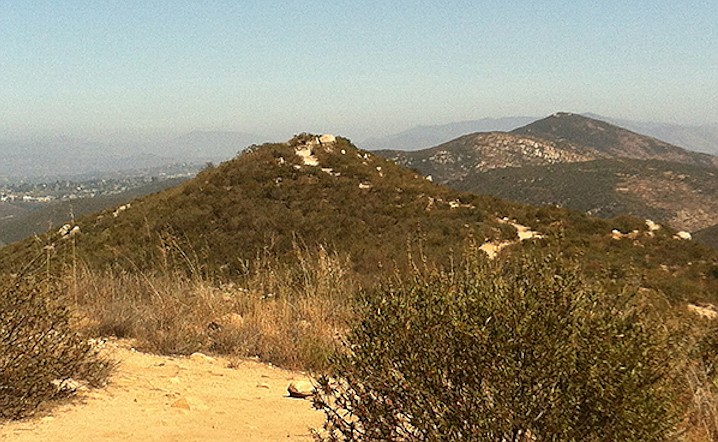
Cowles Mountain as viewed from Pyles Peak
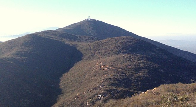
Pyles Peak and Cowles Mountain from North Fortuna
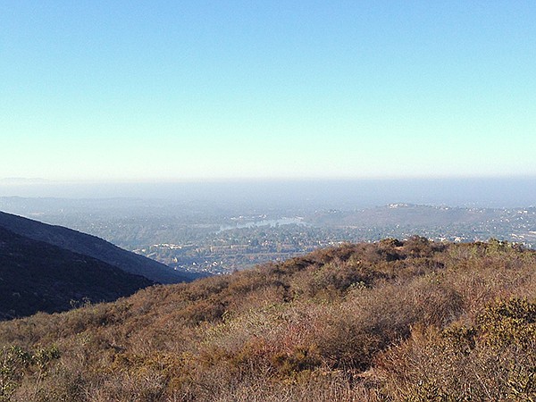
Pyles Peak with Lake Murray in the distance
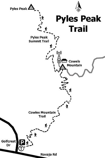
Pyles Peak via Cowles Mountain
Pyles Peak is mid-way between Cowles Mountain on the south and Fortuna Mountain on the north and is part of a series of peaks that was called Long Mountain on some older maps. It has some unrestricted views of the north, east, and west sections of San Diego. The name of the peak dates from 1989 and is probably named for the Pyle family that has been active in conservation circles, according to Leland Fetzer, author of San Diego County Place Names A to Z.
Pyles Peak is accessed through Cowles Mountain, which has three approaches. The most common is the south approach on the corner of Golfcrest and Navajo Road in San Carlos, which is the recommended approach. At 1591 feet, Cowles Mountain is the tallest peak within the city limits of San Diego.
The 1.5-mile trail to the top of Cowles is well marked and is regularly used by nearby residents and at times with their dogs. Upon reaching the summit from any of its three approaches, face north and walk onto the service road that hugs the descending side of the summit. Turn left and walk briefly to its western end where the Pyles Peak trailhead is found on the left. This trail is less traveled.
The Pyles Peak trail is generally well marked and maintained, making for a leisurely and occasionally challenging hike. The trail descends into the chaparral in a northerly direction, followed with multiple ascents and descents along the ridgeline before reaching its destination. The chaparral is low and sparse, dominated by chamise, mission manzanita, and laurel sumac. The elevation, distance from habitation, and the absence of hikers provides quiet, making the call of the occasional wrentit stand out. Scrub jays and Anna’s hummingbirds are frequent companions.
Nearing Pyles Peak, the trail drifts westerly for a bit where a well-marked lookout spot on the lower western corner of the peak is visible. The final ascent to the 1379-foot summit begins here and is fairly straight up to the top. The trail narrows with a loose gravel base, which will challenge even experienced hikers. The reward is an unobstructed view to the north and east, with the Cuyamacas and Lagunas as backdrops.
The return is just over 3 miles, with the first leg to Cowles Mountain a mostly upward hike of 1.6 miles, then a descent for about 1.5 miles back to the trailhead on Golfcrest and Navajo Road.
Distance from downtown San Diego: 13 miles. Allow 20 minutes driving time. Take CA-163N and merge onto I-8E. Exit I-8 at College Ave. and drive north 1 mile, turning right onto Navajo Rd. Continue 2 miles on Navajo Rd. to the Cowles Mountain trailhead on the northeast corner of Navajo Rd. and Golfcrest. Park in the small lot or on the street.
Hiking length: 6.2 miles out and back. Allow 3 hours.
Difficulty: Moderately strenuous because of steep ascents and descents. Elevation gain/loss of 2000 feet. Leashed dogs allowed on trails. Facilities on the corner of Golfcrest and Navajo Rd. in San Carlos. Best in the morning, to avoid heavy use of the Cowles Mountain route. No shade. Trekking poles recommended. Best from October to May, when temperatures are cooler.
Here's something you might be interested in.
Off the beaten path in Mission Trails
The trek to Pyles Peak via Cowles Mountain
Off the beaten path in Mission Trails
The trek to Pyles Peak via Cowles Mountain
Cowles Mountain as viewed from Pyles Peak
Pyles Peak and Cowles Mountain from North Fortuna
Pyles Peak with Lake Murray in the distance
Pyles Peak via Cowles Mountain
Pyles Peak is mid-way between Cowles Mountain on the south and Fortuna Mountain on the north and is part of a series of peaks that was called Long Mountain on some older maps. It has some unrestricted views of the north, east, and west sections of San Diego. The name of the peak dates from 1989 and is probably named for the Pyle family that has been active in conservation circles, according to Leland Fetzer, author of San Diego County Place Names A to Z.
Pyles Peak is accessed through Cowles Mountain, which has three approaches. The most common is the south approach on the corner of Golfcrest and Navajo Road in San Carlos, which is the recommended approach. At 1591 feet, Cowles Mountain is the tallest peak within the city limits of San Diego.
The 1.5-mile trail to the top of Cowles is well marked and is regularly used by nearby residents and at times with their dogs. Upon reaching the summit from any of its three approaches, face north and walk onto the service road that hugs the descending side of the summit. Turn left and walk briefly to its western end where the Pyles Peak trailhead is found on the left. This trail is less traveled.
The Pyles Peak trail is generally well marked and maintained, making for a leisurely and occasionally challenging hike. The trail descends into the chaparral in a northerly direction, followed with multiple ascents and descents along the ridgeline before reaching its destination. The chaparral is low and sparse, dominated by chamise, mission manzanita, and laurel sumac. The elevation, distance from habitation, and the absence of hikers provides quiet, making the call of the occasional wrentit stand out. Scrub jays and Anna’s hummingbirds are frequent companions.
Nearing Pyles Peak, the trail drifts westerly for a bit where a well-marked lookout spot on the lower western corner of the peak is visible. The final ascent to the 1379-foot summit begins here and is fairly straight up to the top. The trail narrows with a loose gravel base, which will challenge even experienced hikers. The reward is an unobstructed view to the north and east, with the Cuyamacas and Lagunas as backdrops.
The return is just over 3 miles, with the first leg to Cowles Mountain a mostly upward hike of 1.6 miles, then a descent for about 1.5 miles back to the trailhead on Golfcrest and Navajo Road.
Distance from downtown San Diego: 13 miles. Allow 20 minutes driving time. Take CA-163N and merge onto I-8E. Exit I-8 at College Ave. and drive north 1 mile, turning right onto Navajo Rd. Continue 2 miles on Navajo Rd. to the Cowles Mountain trailhead on the northeast corner of Navajo Rd. and Golfcrest. Park in the small lot or on the street.
Hiking length: 6.2 miles out and back. Allow 3 hours.
Difficulty: Moderately strenuous because of steep ascents and descents. Elevation gain/loss of 2000 feet. Leashed dogs allowed on trails. Facilities on the corner of Golfcrest and Navajo Rd. in San Carlos. Best in the morning, to avoid heavy use of the Cowles Mountain route. No shade. Trekking poles recommended. Best from October to May, when temperatures are cooler.