Here's something you might be interested in.
Ask a Hipster — Advice you didn't know you needed
Big Screen — Movie commentary
Blurt — Music's inside track
Booze News — San Diego spirits
Classical Music — Immortal beauty
Classifieds — Free and easy
Close to Home — What it’s like on the street where you live
Cover Stories — Front-page features
Drinks All Around — Bartenders' drink recipes
Excerpts — Literary and spiritual excerpts
Feast! — Food & drink reviews
Feature Stories — Local news & stories
Fishing Report — What’s getting hooked from ship and shore
From the Archives — Spotlight on the past
Golden Dreams — Talk of the town
The Gonzo Report — Making the musical scene, or at least reporting from it
Letters — Our inbox
Movies@Home — Local movie buffs share favorites
Movie Reviews — Our critics' picks and pans
Musician Interviews — Up close with local artists
Neighborhood News from Stringers — Hyperlocal news
News Ticker — News & politics
Obermeyer — San Diego politics illustrated
Outdoors — Weekly changes in flora and fauna
Overheard in San Diego — Eavesdropping illustrated
Poetry — The old and the new
Reader Travel — Travel section built by travelers
Reading — The hunt for intellectuals
Roam-O-Rama — SoCal's best hiking/biking trails
San Diego Beer — Inside San Diego suds
SD on the QT — Almost factual news
Sheep and Goats — Places of worship
Special Issues — The best of
Street Style — San Diego streets have style
Surf Diego — Real stories from those braving the waves
Theater — On stage in San Diego this week
Tin Fork — Silver spoon alternative
Under the Radar — Matt Potter's undercover work
Unforgettable — Long-ago San Diego
Unreal Estate — San Diego's priciest pads
Your Week — Daily event picks
Hike along one of the three rivers that discharge into San Diego Bay
Otay Valley Regional Park Loop features ponds, rare flora, and lots of options
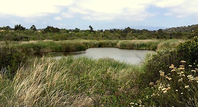
Heart pond, one of the many ponds encountered on the hike.
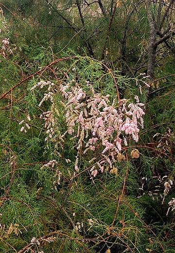
Tamarisk in the riparian areas
Otay Valley Regional Park (OVRP) is an open-space preserve with plans to link the San Diego Wildlife Refuge on San Diego Bay to the Otay River Valley and its headwaters in Otay Lakes and the San Miguel, Jamul, and Otay Mountains, a distance of 13 miles. The planning area encompasses 8869 acres. It is an area with a diversity of vegetation.
The trails in OVRP and its riparian woodlands, marshes, coastal sage scrub, and chaparral habitats make this a great opportunity for bird watching with many good spots to sit, listen, and observe nature. Here, one will find rare plants such as Orcutt’s bird’s beak and endangered birds such as least Bell’s vireo, the southwestern willow flycatcher, and the coastal gnatcatcher. Threatened insects such as Quino checkerspot and Hermes copper butterfly find sanctuary in this regional park.
The area has been continuously inhabited for 9000 years, beginning with the earliest bands of Native Americans that settled into the area. Lands today that include National City, Chula Vista, and Bonita were later included in Rancho del Rey during the Spanish period and then as Rancho de la Nación under the Mexican period. In 1868, the entire rancho was acquired by the Kimble brothers, who retained the name “National” with their purchase. Today, this area is under multi-jurisdictional planning control of San Diego County and the cities of San Diego and Chula Vista.
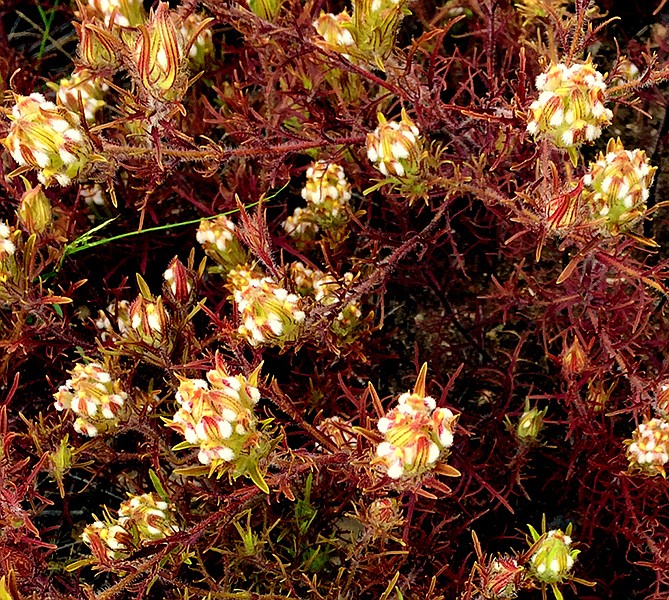
Orcutt’s bird’s beak, one of the area’s rare plants.
The early use of the area for cattle grazing probably led to the introduction of many invasive species, while others have invaded the area since that time. One of the most problematic species is tamarisk/salt cedars found in the riparian areas. These evergreen shrubs have scale-like leaves and are easy to recognize by the dense pink spikes at the branch ends when in bloom. Tamarisks are aggressive usurpers of water, outcompeting native plants and dispersing thousands of seeds when the wind blows. Other invasive plants include the extremely allergenic castor-bean plant, artichoke thistle, Canary Island date palms, crown daisies, and Peruvian pepper trees.
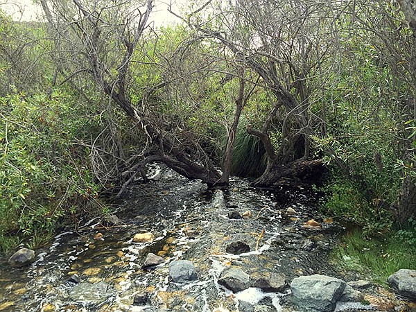
River crossing
There are numerous official trailheads to this park, with about ten miles of trails that crisscross, but the best place to start a hike is at the ranger station at 2155 Beyer Boulevard. From here, you can do a 2-mile loop up one side of the river to Heart Pond and back (crossing the watercourse to Fenton Pond and the ranger station) or a longer 5-mile hike. A map is helpful because of the many intersecting trails. However, any choice is a delight for all hikers — novices will appreciate the wide, flat, meandering trails through the valley floor while all will enjoy the plant varieties encountered. Some of the more common plants include poison oak and broom baccharis along the trails; mule fat, cottonwoods, and sycamores in riparian areas; and flattop buckwheat, coast prickly pear cactus, coastal sage, black sage, chaparral pea, and jimson weed in the chaparral and coastal sage scrub communities.
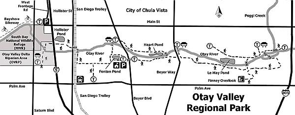
Otay Valley Regional Park Loop
Everyone is advised to use caution when wandering near the trail’s edge due to the proliferation of poison oak throughout the area that will be encountered almost immediately upon leaving the ranger station on Beyer Boulevard. Staying on the trails will afford a rare glimpse of wetlands, ponds, and streams and will keep one safe from contact with poison oak.
The Otay River is one of three rivers that discharge into San Diego Bay. It empties at the southern end of the bay while Sweetwater and San Diego river watersheds discharge further north. Check OVRP’s website, ovrp.org, for more information about the area.
Distance from downtown San Diego: 13 miles. Allow 20 minutes driving time (Chula Vista). Situated between I-5 and I-805 in South Bay San Diego. From I-5, exit Main St. E and drive 1.5 miles to Beyer Blvd. Or, from I-805, drive 2.5 miles west to Beyer Blvd. Turn south on Beyer Blvd. and drive 1 mile to the ranger station on the right (west) and park. The trailhead is across the street on the east side of Beyer Blvd.
Hiking length: 4.5 miles.
Difficulty: Easy, less than 200 feet change in elevation. Hikers, bicycles, equestrians (east of Beyer Blvd) and fishing (with license). Dogs (on leashes) allowed. Facilities.
Here's something you might be interested in.
Hike along one of the three rivers that discharge into San Diego Bay
Otay Valley Regional Park Loop features ponds, rare flora, and lots of options
Hike along one of the three rivers that discharge into San Diego Bay
Otay Valley Regional Park Loop features ponds, rare flora, and lots of options
Heart pond, one of the many ponds encountered on the hike.
Tamarisk in the riparian areas
Otay Valley Regional Park (OVRP) is an open-space preserve with plans to link the San Diego Wildlife Refuge on San Diego Bay to the Otay River Valley and its headwaters in Otay Lakes and the San Miguel, Jamul, and Otay Mountains, a distance of 13 miles. The planning area encompasses 8869 acres. It is an area with a diversity of vegetation.
The trails in OVRP and its riparian woodlands, marshes, coastal sage scrub, and chaparral habitats make this a great opportunity for bird watching with many good spots to sit, listen, and observe nature. Here, one will find rare plants such as Orcutt’s bird’s beak and endangered birds such as least Bell’s vireo, the southwestern willow flycatcher, and the coastal gnatcatcher. Threatened insects such as Quino checkerspot and Hermes copper butterfly find sanctuary in this regional park.
The area has been continuously inhabited for 9000 years, beginning with the earliest bands of Native Americans that settled into the area. Lands today that include National City, Chula Vista, and Bonita were later included in Rancho del Rey during the Spanish period and then as Rancho de la Nación under the Mexican period. In 1868, the entire rancho was acquired by the Kimble brothers, who retained the name “National” with their purchase. Today, this area is under multi-jurisdictional planning control of San Diego County and the cities of San Diego and Chula Vista.
Orcutt’s bird’s beak, one of the area’s rare plants.
The early use of the area for cattle grazing probably led to the introduction of many invasive species, while others have invaded the area since that time. One of the most problematic species is tamarisk/salt cedars found in the riparian areas. These evergreen shrubs have scale-like leaves and are easy to recognize by the dense pink spikes at the branch ends when in bloom. Tamarisks are aggressive usurpers of water, outcompeting native plants and dispersing thousands of seeds when the wind blows. Other invasive plants include the extremely allergenic castor-bean plant, artichoke thistle, Canary Island date palms, crown daisies, and Peruvian pepper trees.
River crossing
There are numerous official trailheads to this park, with about ten miles of trails that crisscross, but the best place to start a hike is at the ranger station at 2155 Beyer Boulevard. From here, you can do a 2-mile loop up one side of the river to Heart Pond and back (crossing the watercourse to Fenton Pond and the ranger station) or a longer 5-mile hike. A map is helpful because of the many intersecting trails. However, any choice is a delight for all hikers — novices will appreciate the wide, flat, meandering trails through the valley floor while all will enjoy the plant varieties encountered. Some of the more common plants include poison oak and broom baccharis along the trails; mule fat, cottonwoods, and sycamores in riparian areas; and flattop buckwheat, coast prickly pear cactus, coastal sage, black sage, chaparral pea, and jimson weed in the chaparral and coastal sage scrub communities.
Otay Valley Regional Park Loop
Everyone is advised to use caution when wandering near the trail’s edge due to the proliferation of poison oak throughout the area that will be encountered almost immediately upon leaving the ranger station on Beyer Boulevard. Staying on the trails will afford a rare glimpse of wetlands, ponds, and streams and will keep one safe from contact with poison oak.
The Otay River is one of three rivers that discharge into San Diego Bay. It empties at the southern end of the bay while Sweetwater and San Diego river watersheds discharge further north. Check OVRP’s website, ovrp.org, for more information about the area.
Distance from downtown San Diego: 13 miles. Allow 20 minutes driving time (Chula Vista). Situated between I-5 and I-805 in South Bay San Diego. From I-5, exit Main St. E and drive 1.5 miles to Beyer Blvd. Or, from I-805, drive 2.5 miles west to Beyer Blvd. Turn south on Beyer Blvd. and drive 1 mile to the ranger station on the right (west) and park. The trailhead is across the street on the east side of Beyer Blvd.
Hiking length: 4.5 miles.
Difficulty: Easy, less than 200 feet change in elevation. Hikers, bicycles, equestrians (east of Beyer Blvd) and fishing (with license). Dogs (on leashes) allowed. Facilities.