Here's something you might be interested in.
Ask a Hipster — Advice you didn't know you needed
Big Screen — Movie commentary
Blurt — Music's inside track
Booze News — San Diego spirits
Classical Music — Immortal beauty
Classifieds — Free and easy
Close to Home — What it’s like on the street where you live
Cover Stories — Front-page features
Drinks All Around — Bartenders' drink recipes
Excerpts — Literary and spiritual excerpts
Feast! — Food & drink reviews
Feature Stories — Local news & stories
Fishing Report — What’s getting hooked from ship and shore
From the Archives — Spotlight on the past
Golden Dreams — Talk of the town
The Gonzo Report — Making the musical scene, or at least reporting from it
Letters — Our inbox
Movies@Home — Local movie buffs share favorites
Movie Reviews — Our critics' picks and pans
Musician Interviews — Up close with local artists
Neighborhood News from Stringers — Hyperlocal news
News Ticker — News & politics
Obermeyer — San Diego politics illustrated
Outdoors — Weekly changes in flora and fauna
Overheard in San Diego — Eavesdropping illustrated
Poetry — The old and the new
Reader Travel — Travel section built by travelers
Reading — The hunt for intellectuals
Roam-O-Rama — SoCal's best hiking/biking trails
San Diego Beer — Inside San Diego suds
SD on the QT — Almost factual news
Sheep and Goats — Places of worship
Special Issues — The best of
Street Style — San Diego streets have style
Surf Diego — Real stories from those braving the waves
Theater — On stage in San Diego this week
Tin Fork — Silver spoon alternative
Under the Radar — Matt Potter's undercover work
Unforgettable — Long-ago San Diego
Unreal Estate — San Diego's priciest pads
Your Week — Daily event picks
Borrego Badlands, here we come
Seeking out Fonts Point and Inspiration Point in Anza-Borrego Desert State Park
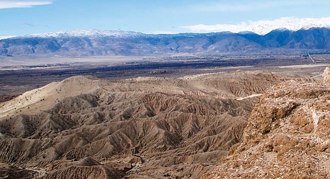
The view of the western badlands on a clear day
Fonts Point and Inspiration Point are two of the most scenic overlooks in the Anza-Borrego Desert. After traveling several miles through a sandy wash and hiking across a relatively flat mesa with fairly typical desert scenery, you arrive at the top of a cliff overlooking an astounding labyrinth of multihued canyons and steep, sharp-ridged hills that extend before you, covering several square miles. This contorted landscape is known as the Borrego Badlands. Inspiration Point overlooks the western part of the badlands while Fonts Point gives you views mainly to the south and east.
Fonts Point was named for Pedro Font, a Franciscan priest who was selected for the 1775 Anza Expedition for his ability to use a quadrant to help navigate and record the route traveled. He kept a diary and was the first European to write in detail about the Anza-Borrego Desert. It seems rather odd that this beautiful point was named for a man who found little to praise about the landscape, Anza, or the colonists on the expedition. He was, however, observant and was the first to note the presence of bighorn sheep in the area.
Drive 3.1 miles up Fonts Point wash, park, and begin hiking west cross-country to Inspiration Point. There is no official trail, but the terrain consists of rolling hills with sparse vegetation and is easily negotiated. Continue hiking west to the highest hill on the near horizon, Inspiration Point, 0.4 mile ahead.
On your way, be sure to take time to examine the sedimentary rocks as you pass. Half a million years ago or so, these were part of the Santa Rosa Mountains. Over millennia, layers of sediment eroding from the rising Santa Rosa Mountains accumulated here, forming the sand and mudstone of these hills. The climate has changed significantly since these depositions occurred, becoming much warmer and dryer. There are fossils embedded within these rocks of numerous large herbivores, including camels, horses, mammoths, and ground sloths, as well as meat-eating predators such as the saber-toothed cat, the bone-eating dog, and the wolf coyote, showing that a cooler, wetter, more verdant landscape existed here over much of the past 2 million years. If you stop on the way to look at the layered sandstone for fossils, remember that if a fossil is found, it is protected: no excavating or taking of samples is allowed. Also, if you want to stop, don’t do it while driving through soft sand or you may be there for a long time.
An outstanding view of the western Borrego Badlands is the reward for hiking out to Inspiration Point. After taking in the view, start hiking south-southeast along the ridge above the badlands, being careful not to get too close to the edge, as these cliffs are unstable. Head toward the highest hill in the near distance, which is Fonts Point itself.
You may notice that as you drove south on Fonts Point Wash you were going up a gradual hill. The wash, which now flows into Clark Valley, was once tilted the other way, with sediment flowing south. The earth’s crust under Anza-Borrego is highly mobile, and Fonts Wash sits on a block that has tilted up while the block underlying Clark Dry Lake to the north is sinking. Currently, Fonts Point is about 700 feet higher than the floor of Clark Valley. For at least the past 10,000 years, the block of land around Fonts Point has been eroding in a spectacular way with most of the eroded sediment flowing to the south, as you will see when you arrive at the point.
After taking in the eroding landscape, return to your vehicle by following the dirt road 1.1 miles north from Fonts Point.
In the November-to-January time frame, there may be Psorothamnus emoryi or indigo bush in bloom that has Pilostyles thurberi infestation on stem(s). Pilostyles thurberi (or Thurber’s stemsucker) is an uncommon small parasite with 2mm flowers.
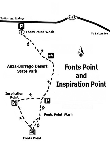
- Distance from downtown San Diego: About 95 miles. Allow 2 hours and 15 minutes driving time. First drive about 85 miles to Christmas Circle in Borrego Springs. From Christmas Circle, go east about 10 miles on the Salton Seaway, Highway SR-22, to Fonts Point Wash at milepost 29.3. Turn right into the broad, sandy wash. Drive 3.1 miles up Fonts Point Wash, passing the turnoff to Short Wash to the left after about 2 miles, and continuing to the right for the last mile and park.
- Hiking length: 2.6-mile loop.
- Difficulty: Moderate if done on a hot day, but an easy hike on a day with mild temperatures. Elevation loss/gain 200 feet. The best time to visit is in the early morning or late afternoon, about an hour after sunrise or before sunset from October through May, on a day when the atmosphere is clear. The main hazard is driving in soft sand and getting your vehicle stuck on the drive up Fonts Point Wash, especially if you attempt it in a passenger car. Four-wheel-drive vehicles are strongly recommended. Use caution near the drop-off at the point. There are no facilities or sources of drinking water anywhere near this area. Leashed dogs are allowed only on designated roads and not at the point.
Here's something you might be interested in.
Borrego Badlands, here we come
Seeking out Fonts Point and Inspiration Point in Anza-Borrego Desert State Park
Borrego Badlands, here we come
Seeking out Fonts Point and Inspiration Point in Anza-Borrego Desert State Park
The view of the western badlands on a clear day
Fonts Point and Inspiration Point are two of the most scenic overlooks in the Anza-Borrego Desert. After traveling several miles through a sandy wash and hiking across a relatively flat mesa with fairly typical desert scenery, you arrive at the top of a cliff overlooking an astounding labyrinth of multihued canyons and steep, sharp-ridged hills that extend before you, covering several square miles. This contorted landscape is known as the Borrego Badlands. Inspiration Point overlooks the western part of the badlands while Fonts Point gives you views mainly to the south and east.
Fonts Point was named for Pedro Font, a Franciscan priest who was selected for the 1775 Anza Expedition for his ability to use a quadrant to help navigate and record the route traveled. He kept a diary and was the first European to write in detail about the Anza-Borrego Desert. It seems rather odd that this beautiful point was named for a man who found little to praise about the landscape, Anza, or the colonists on the expedition. He was, however, observant and was the first to note the presence of bighorn sheep in the area.
Drive 3.1 miles up Fonts Point wash, park, and begin hiking west cross-country to Inspiration Point. There is no official trail, but the terrain consists of rolling hills with sparse vegetation and is easily negotiated. Continue hiking west to the highest hill on the near horizon, Inspiration Point, 0.4 mile ahead.
On your way, be sure to take time to examine the sedimentary rocks as you pass. Half a million years ago or so, these were part of the Santa Rosa Mountains. Over millennia, layers of sediment eroding from the rising Santa Rosa Mountains accumulated here, forming the sand and mudstone of these hills. The climate has changed significantly since these depositions occurred, becoming much warmer and dryer. There are fossils embedded within these rocks of numerous large herbivores, including camels, horses, mammoths, and ground sloths, as well as meat-eating predators such as the saber-toothed cat, the bone-eating dog, and the wolf coyote, showing that a cooler, wetter, more verdant landscape existed here over much of the past 2 million years. If you stop on the way to look at the layered sandstone for fossils, remember that if a fossil is found, it is protected: no excavating or taking of samples is allowed. Also, if you want to stop, don’t do it while driving through soft sand or you may be there for a long time.
An outstanding view of the western Borrego Badlands is the reward for hiking out to Inspiration Point. After taking in the view, start hiking south-southeast along the ridge above the badlands, being careful not to get too close to the edge, as these cliffs are unstable. Head toward the highest hill in the near distance, which is Fonts Point itself.
You may notice that as you drove south on Fonts Point Wash you were going up a gradual hill. The wash, which now flows into Clark Valley, was once tilted the other way, with sediment flowing south. The earth’s crust under Anza-Borrego is highly mobile, and Fonts Wash sits on a block that has tilted up while the block underlying Clark Dry Lake to the north is sinking. Currently, Fonts Point is about 700 feet higher than the floor of Clark Valley. For at least the past 10,000 years, the block of land around Fonts Point has been eroding in a spectacular way with most of the eroded sediment flowing to the south, as you will see when you arrive at the point.
After taking in the eroding landscape, return to your vehicle by following the dirt road 1.1 miles north from Fonts Point.
In the November-to-January time frame, there may be Psorothamnus emoryi or indigo bush in bloom that has Pilostyles thurberi infestation on stem(s). Pilostyles thurberi (or Thurber’s stemsucker) is an uncommon small parasite with 2mm flowers.
- Distance from downtown San Diego: About 95 miles. Allow 2 hours and 15 minutes driving time. First drive about 85 miles to Christmas Circle in Borrego Springs. From Christmas Circle, go east about 10 miles on the Salton Seaway, Highway SR-22, to Fonts Point Wash at milepost 29.3. Turn right into the broad, sandy wash. Drive 3.1 miles up Fonts Point Wash, passing the turnoff to Short Wash to the left after about 2 miles, and continuing to the right for the last mile and park.
- Hiking length: 2.6-mile loop.
- Difficulty: Moderate if done on a hot day, but an easy hike on a day with mild temperatures. Elevation loss/gain 200 feet. The best time to visit is in the early morning or late afternoon, about an hour after sunrise or before sunset from October through May, on a day when the atmosphere is clear. The main hazard is driving in soft sand and getting your vehicle stuck on the drive up Fonts Point Wash, especially if you attempt it in a passenger car. Four-wheel-drive vehicles are strongly recommended. Use caution near the drop-off at the point. There are no facilities or sources of drinking water anywhere near this area. Leashed dogs are allowed only on designated roads and not at the point.