Here's something you might be interested in.
Ask a Hipster — Advice you didn't know you needed
Big Screen — Movie commentary
Blurt — Music's inside track
Booze News — San Diego spirits
Classical Music — Immortal beauty
Classifieds — Free and easy
Cover Stories — Front-page features
Drinks All Around — Bartenders' drink recipes
Excerpts — Literary and spiritual excerpts
Feast! — Food & drink reviews
Feature Stories — Local news & stories
Fishing Report — What’s getting hooked from ship and shore
From the Archives — Spotlight on the past
Golden Dreams — Talk of the town
The Gonzo Report — Making the musical scene, or at least reporting from it
Letters — Our inbox
Movies@Home — Local movie buffs share favorites
Movie Reviews — Our critics' picks and pans
Musician Interviews — Up close with local artists
Neighborhood News from Stringers — Hyperlocal news
News Ticker — News & politics
Obermeyer — San Diego politics illustrated
Outdoors — Weekly changes in flora and fauna
Overheard in San Diego — Eavesdropping illustrated
Poetry — The old and the new
Reader Travel — Travel section built by travelers
Reading — The hunt for intellectuals
Roam-O-Rama — SoCal's best hiking/biking trails
San Diego Beer — Inside San Diego suds
SD on the QT — Almost factual news
Sheep and Goats — Places of worship
Special Issues — The best of
Street Style — San Diego streets have style
Surf Diego — Real stories from those braving the waves
Theater — On stage in San Diego this week
Tin Fork — Silver spoon alternative
Under the Radar — Matt Potter's undercover work
Unforgettable — Long-ago San Diego
Unreal Estate — San Diego's priciest pads
Your Week — Daily event picks
Anza-Borrego's Font's Point Has Best View of Badlands
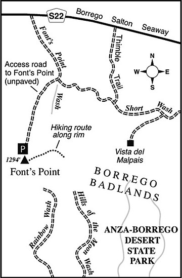
Q: What are badlands? A: “Wasteland” that has been eroded into unusual shapes by wind and water — originally from the French term les mauvaises terres. Our local version of this, the Borrego Badlands in Anza-Borrego Desert State Park, consists of soft, waterborne sediments that have been deeply carved by water and wind over many thousands of years. Because the area’s clay soils are weak and plant life is sparse, flash floods and other erosive forces have shaped the landscape into a bewildering maze of sinuous channels, razorback ridges, and mud hills. At Font’s Point, you can stand on the edge of a receding (well, geologically speaking) cliff, and gaze across square miles’ worth of this fascinating landscape. Yes, you can drive to just shy of the point itself, and yes, a little additional travel on foot gives new and different perspectives.
To get to Font’s Point from Borrego Springs, follow Highway S-22 (Palm Canyon Drive, Pegleg Road, and Borrego Salton Seaway) generally east for about ten miles to Font’s Point Wash, at mile 29.3 according to the roadside mile markers. Turn right, following sandy tire tracks heading south up the wash. (The initial section may be plagued with patches of soft sand, and therefore unsuitable for conventional 2-wheel drive vehicles.) After 4.5 miles, you come to the outbound segment, on the left, of a one-way loop road. Take this left fork, and you’ll soon arrive at a parking area just short of the Font’s Point dropoff.
The interpretive panels at the point itself illuminate the geologic history of the badlands and identify geographical features near and far. Starting from the parking area, you can walk east alongside (but not on the very brink of) the cliffs for half a mile or more. Here and there along this viewful stretch, on the way over or back, you might walk (cautiously) over toward the cliff edge, where mile upon mile of convoluted landscape unfolds below. Up to about one hour after sunrise and one hour before sunset, the razorback ridges down below cast bold shadows across the honey-colored hills — perfect lighting for photography-minded visitors. Remember to approach the brink cautiously, especially if you have kids. In a couple of places, large blocks of the cliff face are beginning to cleave.
This article contains information about a publicly owned recreation or wilderness area. Trails and pathways are not necessarily marked. Conditions can change rapidly. Hikers should be properly equipped and have safety and navigational skills. The Reader and Jerry Schad assume no responsibility for any adverse experience.
FONT’S POINT
Anza-Borrego’s Font’s Point area has the best view of local “badlands.”
Distance from downtown San Diego: 106 miles
Hiking length: 1+ mile round trip
Difficulty: Easy
Here's something you might be interested in.
Anza-Borrego's Font's Point Has Best View of Badlands
Anza-Borrego's Font's Point Has Best View of Badlands
Q: What are badlands? A: “Wasteland” that has been eroded into unusual shapes by wind and water — originally from the French term les mauvaises terres. Our local version of this, the Borrego Badlands in Anza-Borrego Desert State Park, consists of soft, waterborne sediments that have been deeply carved by water and wind over many thousands of years. Because the area’s clay soils are weak and plant life is sparse, flash floods and other erosive forces have shaped the landscape into a bewildering maze of sinuous channels, razorback ridges, and mud hills. At Font’s Point, you can stand on the edge of a receding (well, geologically speaking) cliff, and gaze across square miles’ worth of this fascinating landscape. Yes, you can drive to just shy of the point itself, and yes, a little additional travel on foot gives new and different perspectives.
To get to Font’s Point from Borrego Springs, follow Highway S-22 (Palm Canyon Drive, Pegleg Road, and Borrego Salton Seaway) generally east for about ten miles to Font’s Point Wash, at mile 29.3 according to the roadside mile markers. Turn right, following sandy tire tracks heading south up the wash. (The initial section may be plagued with patches of soft sand, and therefore unsuitable for conventional 2-wheel drive vehicles.) After 4.5 miles, you come to the outbound segment, on the left, of a one-way loop road. Take this left fork, and you’ll soon arrive at a parking area just short of the Font’s Point dropoff.
The interpretive panels at the point itself illuminate the geologic history of the badlands and identify geographical features near and far. Starting from the parking area, you can walk east alongside (but not on the very brink of) the cliffs for half a mile or more. Here and there along this viewful stretch, on the way over or back, you might walk (cautiously) over toward the cliff edge, where mile upon mile of convoluted landscape unfolds below. Up to about one hour after sunrise and one hour before sunset, the razorback ridges down below cast bold shadows across the honey-colored hills — perfect lighting for photography-minded visitors. Remember to approach the brink cautiously, especially if you have kids. In a couple of places, large blocks of the cliff face are beginning to cleave.
This article contains information about a publicly owned recreation or wilderness area. Trails and pathways are not necessarily marked. Conditions can change rapidly. Hikers should be properly equipped and have safety and navigational skills. The Reader and Jerry Schad assume no responsibility for any adverse experience.
FONT’S POINT
Anza-Borrego’s Font’s Point area has the best view of local “badlands.”
Distance from downtown San Diego: 106 miles
Hiking length: 1+ mile round trip
Difficulty: Easy