Here's something you might be interested in.
Ask a Hipster — Advice you didn't know you needed
Big Screen — Movie commentary
Blurt — Music's inside track
Booze News — San Diego spirits
Classical Music — Immortal beauty
Classifieds — Free and easy
Close to Home — What it’s like on the street where you live
Cover Stories — Front-page features
Drinks All Around — Bartenders' drink recipes
Excerpts — Literary and spiritual excerpts
Feast! — Food & drink reviews
Feature Stories — Local news & stories
Fishing Report — What’s getting hooked from ship and shore
From the Archives — Spotlight on the past
Golden Dreams — Talk of the town
The Gonzo Report — Making the musical scene, or at least reporting from it
Letters — Our inbox
Movies@Home — Local movie buffs share favorites
Movie Reviews — Our critics' picks and pans
Musician Interviews — Up close with local artists
Neighborhood News from Stringers — Hyperlocal news
News Ticker — News & politics
Obermeyer — San Diego politics illustrated
Outdoors — Weekly changes in flora and fauna
Overheard in San Diego — Eavesdropping illustrated
Poetry — The old and the new
Reader Travel — Travel section built by travelers
Reading — The hunt for intellectuals
Roam-O-Rama — SoCal's best hiking/biking trails
San Diego Beer — Inside San Diego suds
SD on the QT — Almost factual news
Sheep and Goats — Places of worship
Special Issues — The best of
Street Style — San Diego streets have style
Surf Diego — Real stories from those braving the waves
Theater — On stage in San Diego this week
Tin Fork — Silver spoon alternative
Under the Radar — Matt Potter's undercover work
Unforgettable — Long-ago San Diego
Unreal Estate — San Diego's priciest pads
Your Week — Daily event picks
Late-season climb on Mount San Jacinto
Two hours from S.D., million-dollar views await.
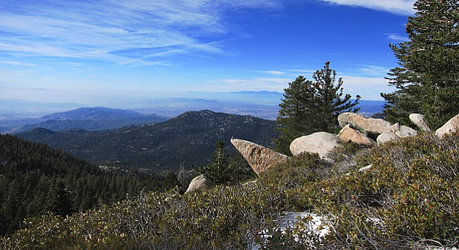
Well worth the climb: view from the trail over the Inland Empire.
The 360° vista from Mount San Jacinto's 10,834-foot summit is breathtaking: Southern California’s parched land hopscotches sprawling metropolis in every direction. Palm Springs spreads like a patchwork quilt in the east. Riverside and San Bernardino lie in a haze under the silhouette of the San Bernardino Mountains. Perris, Murrieta and Temecula wind through thin peninsular ranges in the south. Vehicles looks like ants on Interstate 10 as it snakes through the desert.
As crisp mountain breezes whip my face, Southern California’s bloated urban centers seem remote and even beautiful. Pulling my balaclava over my ears, I hunker down behind a boulder and enjoy the view.
It’s Saturday morning. Slightly before 7 a.m., I ease my beleaguered 2001 Mitsubishi Galant into Deer Creek trailhead’s pull-out-cum-parking-lot across the CA-243 from Idyllwild’s Nature Center. Only two other vehicles are parked, and a smiling trio of hikers wave as I lace my boots and scarf a banana. “Have you ever hiked this trail?” one asks.
“Yes,” I reply. Looking at the blue sky, I add “It’s going to be a beautiful day!”
Mt. San Jacinto: the way up
After a few light stretches, I set a tortuous pace up the first two switchback miles. It’s still dark outside, and the steep hillsides are wooded with shadowy California black walnut and mountain mahogany. Although the air is frigid, especially in the runoff ravines and fissures, I peel off my Patagonia shell to avoid swamping myself with a chilling sweat.
As the trail gains elevation, the Jeffrey pine and white fir canopy obscures views of the arid peninsular ranges to the south. Small blotches of snowfall cover more and more of the forest floor until I am hiking continuously on a few inches of crunchy snow. Wishing I had brought my arctic-worthy Swix gauntlets, I decelerate to a sustainable stride.
Mount San Jacinto, the second-highest peak in Southern California, rises in the center of San Jacinto and Santa Rosa Mountains National Monument. The monument encompasses 280,000 acres of protected ridgeline wilderness – boulder-strewn hillsides, pine forests, and an incredible display of biodiversity in this desert-to-mountaintop transition zone. Trails may be busy at peak seasons, but a hiking permit system prevents overuse and protects fragile ecosystems. Setting out before dawn can ensure that you beat the rush at any time of year.
I am thankfully following a lone hiker’s snow prints instead of blazing my own wandering route through the white-blanketed forest. Scurrying noises from well-fed gray squirrels and the occasional falling pinecone keep me alert.
Approaching Strawberry Junction a little over four miles in, I find a rocky outcrop that crowns a cliff-like slope. Laying down my well-worn Black Diamond trekking poles, I devour a Cliff Bar. Although the distant marine layer obscures Los Angeles and the Pacific Ocean, the enormity of the landscape is palpable. After a few moments of reflection, I snap on my Neeko lumbar hydration pack and trudge on.
San Jacinto wilderness is the perfect day hike or overnight backpacking destination for those looking for a strenuous weekend excursion. Less than two hours from San Diego and a little more than two hours from downtown Los Angeles, the wilderness is a rejuvenating refuge of alpine wildlife. Despite being in the middle of Southern California’s vast hubbub, it's amazing how quickly the sounds and emotional proximity to the city recede while plodding through the quiet forests.
Home stretch
My route joins the Pacific Crest Trail, passes the Marion Mountain and Seven Pines cutoffs, and climbs a series of switchbacks up a hillside thickly matted with bushy squaw currants. I pass through Little Round Valley, picturesque with a thin meadow and stream, which contains several designated campsites with names like “Owl’s Hooch” and “Granite Gully.” The bright sun cheerfully reflects on the winter wonderland carpet of snow. Hunched over my poles, I begin the final 1,000-foot, one-and-a-half-mile slog to the summit.
The trail disappears as I billy-goat over icy boulders – the summit's just ahead! A little under four hours after beginning, I finally arrive at the peak and celebrate the moment by taking a selfie with the summit signpost. Swift wispy clouds don't linger long enough to block the sun, but the ice-cold wind is torrential.
Soaking up the 360° views, I find a less exposed perch. Did it!
After a few moments savoring the achievement, I maneuver carefully over the slippery rocks and begin the downhill journey. Even at the end of November, Mount San Jacinto does not disappoint as a quick day-hike getaway.
If you go
Hiking to the summit of Mount San Jacinto via Deer Springs trail is a demanding 10-miles there, 10-miles back roundtrip. Trails are well maintained, although snow conditions may be present. Be prepared for significant elevation gain; rely on either your GPS device or a handy Tom Harrison map of the area.
Views and scenery are a hands-down “10.” Permits are required for entry into the wilderness. For more information, visit parks.ca.gov.
Editor's note: you can also take the Palm Springs tramway for a San Jacinto "shortcut" that saves four miles each way.
Here's something you might be interested in.
Late-season climb on Mount San Jacinto
Two hours from S.D., million-dollar views await.
Late-season climb on Mount San Jacinto
Two hours from S.D., million-dollar views await.
Well worth the climb: view from the trail over the Inland Empire.
The 360° vista from Mount San Jacinto's 10,834-foot summit is breathtaking: Southern California’s parched land hopscotches sprawling metropolis in every direction. Palm Springs spreads like a patchwork quilt in the east. Riverside and San Bernardino lie in a haze under the silhouette of the San Bernardino Mountains. Perris, Murrieta and Temecula wind through thin peninsular ranges in the south. Vehicles looks like ants on Interstate 10 as it snakes through the desert.
As crisp mountain breezes whip my face, Southern California’s bloated urban centers seem remote and even beautiful. Pulling my balaclava over my ears, I hunker down behind a boulder and enjoy the view.
It’s Saturday morning. Slightly before 7 a.m., I ease my beleaguered 2001 Mitsubishi Galant into Deer Creek trailhead’s pull-out-cum-parking-lot across the CA-243 from Idyllwild’s Nature Center. Only two other vehicles are parked, and a smiling trio of hikers wave as I lace my boots and scarf a banana. “Have you ever hiked this trail?” one asks.
“Yes,” I reply. Looking at the blue sky, I add “It’s going to be a beautiful day!”
Mt. San Jacinto: the way up
After a few light stretches, I set a tortuous pace up the first two switchback miles. It’s still dark outside, and the steep hillsides are wooded with shadowy California black walnut and mountain mahogany. Although the air is frigid, especially in the runoff ravines and fissures, I peel off my Patagonia shell to avoid swamping myself with a chilling sweat.
As the trail gains elevation, the Jeffrey pine and white fir canopy obscures views of the arid peninsular ranges to the south. Small blotches of snowfall cover more and more of the forest floor until I am hiking continuously on a few inches of crunchy snow. Wishing I had brought my arctic-worthy Swix gauntlets, I decelerate to a sustainable stride.
Mount San Jacinto, the second-highest peak in Southern California, rises in the center of San Jacinto and Santa Rosa Mountains National Monument. The monument encompasses 280,000 acres of protected ridgeline wilderness – boulder-strewn hillsides, pine forests, and an incredible display of biodiversity in this desert-to-mountaintop transition zone. Trails may be busy at peak seasons, but a hiking permit system prevents overuse and protects fragile ecosystems. Setting out before dawn can ensure that you beat the rush at any time of year.
I am thankfully following a lone hiker’s snow prints instead of blazing my own wandering route through the white-blanketed forest. Scurrying noises from well-fed gray squirrels and the occasional falling pinecone keep me alert.
Approaching Strawberry Junction a little over four miles in, I find a rocky outcrop that crowns a cliff-like slope. Laying down my well-worn Black Diamond trekking poles, I devour a Cliff Bar. Although the distant marine layer obscures Los Angeles and the Pacific Ocean, the enormity of the landscape is palpable. After a few moments of reflection, I snap on my Neeko lumbar hydration pack and trudge on.
San Jacinto wilderness is the perfect day hike or overnight backpacking destination for those looking for a strenuous weekend excursion. Less than two hours from San Diego and a little more than two hours from downtown Los Angeles, the wilderness is a rejuvenating refuge of alpine wildlife. Despite being in the middle of Southern California’s vast hubbub, it's amazing how quickly the sounds and emotional proximity to the city recede while plodding through the quiet forests.
Home stretch
My route joins the Pacific Crest Trail, passes the Marion Mountain and Seven Pines cutoffs, and climbs a series of switchbacks up a hillside thickly matted with bushy squaw currants. I pass through Little Round Valley, picturesque with a thin meadow and stream, which contains several designated campsites with names like “Owl’s Hooch” and “Granite Gully.” The bright sun cheerfully reflects on the winter wonderland carpet of snow. Hunched over my poles, I begin the final 1,000-foot, one-and-a-half-mile slog to the summit.
The trail disappears as I billy-goat over icy boulders – the summit's just ahead! A little under four hours after beginning, I finally arrive at the peak and celebrate the moment by taking a selfie with the summit signpost. Swift wispy clouds don't linger long enough to block the sun, but the ice-cold wind is torrential.
Soaking up the 360° views, I find a less exposed perch. Did it!
After a few moments savoring the achievement, I maneuver carefully over the slippery rocks and begin the downhill journey. Even at the end of November, Mount San Jacinto does not disappoint as a quick day-hike getaway.
If you go
Hiking to the summit of Mount San Jacinto via Deer Springs trail is a demanding 10-miles there, 10-miles back roundtrip. Trails are well maintained, although snow conditions may be present. Be prepared for significant elevation gain; rely on either your GPS device or a handy Tom Harrison map of the area.
Views and scenery are a hands-down “10.” Permits are required for entry into the wilderness. For more information, visit parks.ca.gov.
Editor's note: you can also take the Palm Springs tramway for a San Jacinto "shortcut" that saves four miles each way.
Comments