Here's something you might be interested in.
Ask a Hipster — Advice you didn't know you needed
Big Screen — Movie commentary
Blurt — Music's inside track
Booze News — San Diego spirits
Classical Music — Immortal beauty
Classifieds — Free and easy
Close to Home — What it’s like on the street where you live
Cover Stories — Front-page features
Drinks All Around — Bartenders' drink recipes
Excerpts — Literary and spiritual excerpts
Feast! — Food & drink reviews
Feature Stories — Local news & stories
Fishing Report — What’s getting hooked from ship and shore
From the Archives — Spotlight on the past
Golden Dreams — Talk of the town
The Gonzo Report — Making the musical scene, or at least reporting from it
Letters — Our inbox
Movies@Home — Local movie buffs share favorites
Movie Reviews — Our critics' picks and pans
Musician Interviews — Up close with local artists
Neighborhood News from Stringers — Hyperlocal news
News Ticker — News & politics
Obermeyer — San Diego politics illustrated
Outdoors — Weekly changes in flora and fauna
Overheard in San Diego — Eavesdropping illustrated
Poetry — The old and the new
Reader Travel — Travel section built by travelers
Reading — The hunt for intellectuals
Roam-O-Rama — SoCal's best hiking/biking trails
San Diego Beer — Inside San Diego suds
SD on the QT — Almost factual news
Sheep and Goats — Places of worship
Special Issues — The best of
Street Style — San Diego streets have style
Surf Diego — Real stories from those braving the waves
Theater — On stage in San Diego this week
Tin Fork — Silver spoon alternative
Under the Radar — Matt Potter's undercover work
Unforgettable — Long-ago San Diego
Unreal Estate — San Diego's priciest pads
Your Week — Daily event picks
Hike or bike to Sunset Peak Summit, near Mount Baldy
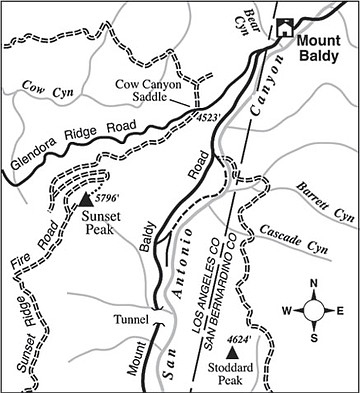
The hike (or mountain-bike ride) to Sunset Peak, near the community of Mount Baldy, offers up fine views of an archipelago of high peaks stretching from San Gabriel Wilderness in the west to Cucamonga Wilderness in the east. Mount San Antonio (a.k.a. Old Baldy) rises from center stage in the north, its bald summit sometimes accented by a brilliant snow cap. Prepare for six miles of round-trip hiking, or eight miles by mountain bike, and an elevation gain and loss of 1200 feet. Need we say bring drinking water along?
To get to the starting point, exit the 210 Freeway at Baseline Road on the border between the cities of Claremont and Upland. Go west on Baseline for 0.7 mile, then turn right (north) on Mills Avenue. After 1.1 mile the main road (signed Mount Baldy Road) veers right. Stay on it and drive uphill another eight miles to Mount Baldy village. Just as you approach the village, turn left on Glendora Ridge Road. Follow it one mile to Cow Canyon Saddle, where parking space is available on the left side of the road. Since you are on Angeles National Forest land, don’t forget to post a National Forest Adventure Pass on your parked car.
From Cow Canyon Saddle, start hiking up the gated fire road on the south side of the road. You gain elevation steadily, accompanied by fire-scarred vegetation: newly minted chaparral, remnant live oaks, bigcone Douglas-firs, and bigleaf maples. Since you are traveling along mostly north-facing slopes, the view keeps expanding in the north, where the higher peaks of the San Gabriel Mountains rise to nearly a two-mile elevation.
You reverse direction at horseshoe curves at 1.9 miles, and again at 2.5 miles. Just after the latter switchback, if you’re on foot, you can bear left on an old fire break and head southwest straight to the summit. This worthwhile and fun shortcut, with some easy rock-scrambling at the top, saves time and distance over the alternative — a mile of tedious road-walking. On a mountain bike, the extra mile of distance is necessary, as the hikers’ short-cut is simply too steep and rough.
Sunset Peak’s flat, barren summit once hosted a fire lookout tower. Try to find the building’s foundation and also the remains of a rainwater collection system. Much of what lies in view to the south is a large, closed-to-the-public parcel of the Angeles National Forest called the San Dimas Experimental Forest. Much of our current knowledge about fire ecology and erosion in the chaparral plant community has been gained from carefully controlled experiments performed in this outdoor laboratory over the past seven or eight decades.
This article contains information about a publicly owned recreation or wilderness area. Trails and pathways are not necessarily marked. Conditions can change rapidly. Hikers should be properly equipped and have safety and navigational skills. The Reader and Jerry Schad assume no responsibility for any adverse experience.
SUNSET PEAK
Hike or mountain bike to the Sunset Peak summit, near Mount Baldy.
Distance from downtown San Diego: 132 miles
Hiking length: 6 miles round trip
Difficulty: Moderate
Here's something you might be interested in.
Hike or bike to Sunset Peak Summit, near Mount Baldy
Hike or bike to Sunset Peak Summit, near Mount Baldy
The hike (or mountain-bike ride) to Sunset Peak, near the community of Mount Baldy, offers up fine views of an archipelago of high peaks stretching from San Gabriel Wilderness in the west to Cucamonga Wilderness in the east. Mount San Antonio (a.k.a. Old Baldy) rises from center stage in the north, its bald summit sometimes accented by a brilliant snow cap. Prepare for six miles of round-trip hiking, or eight miles by mountain bike, and an elevation gain and loss of 1200 feet. Need we say bring drinking water along?
To get to the starting point, exit the 210 Freeway at Baseline Road on the border between the cities of Claremont and Upland. Go west on Baseline for 0.7 mile, then turn right (north) on Mills Avenue. After 1.1 mile the main road (signed Mount Baldy Road) veers right. Stay on it and drive uphill another eight miles to Mount Baldy village. Just as you approach the village, turn left on Glendora Ridge Road. Follow it one mile to Cow Canyon Saddle, where parking space is available on the left side of the road. Since you are on Angeles National Forest land, don’t forget to post a National Forest Adventure Pass on your parked car.
From Cow Canyon Saddle, start hiking up the gated fire road on the south side of the road. You gain elevation steadily, accompanied by fire-scarred vegetation: newly minted chaparral, remnant live oaks, bigcone Douglas-firs, and bigleaf maples. Since you are traveling along mostly north-facing slopes, the view keeps expanding in the north, where the higher peaks of the San Gabriel Mountains rise to nearly a two-mile elevation.
You reverse direction at horseshoe curves at 1.9 miles, and again at 2.5 miles. Just after the latter switchback, if you’re on foot, you can bear left on an old fire break and head southwest straight to the summit. This worthwhile and fun shortcut, with some easy rock-scrambling at the top, saves time and distance over the alternative — a mile of tedious road-walking. On a mountain bike, the extra mile of distance is necessary, as the hikers’ short-cut is simply too steep and rough.
Sunset Peak’s flat, barren summit once hosted a fire lookout tower. Try to find the building’s foundation and also the remains of a rainwater collection system. Much of what lies in view to the south is a large, closed-to-the-public parcel of the Angeles National Forest called the San Dimas Experimental Forest. Much of our current knowledge about fire ecology and erosion in the chaparral plant community has been gained from carefully controlled experiments performed in this outdoor laboratory over the past seven or eight decades.
This article contains information about a publicly owned recreation or wilderness area. Trails and pathways are not necessarily marked. Conditions can change rapidly. Hikers should be properly equipped and have safety and navigational skills. The Reader and Jerry Schad assume no responsibility for any adverse experience.
SUNSET PEAK
Hike or mountain bike to the Sunset Peak summit, near Mount Baldy.
Distance from downtown San Diego: 132 miles
Hiking length: 6 miles round trip
Difficulty: Moderate