Here's something you might be interested in.
Ask a Hipster — Advice you didn't know you needed
Big Screen — Movie commentary
Blurt — Music's inside track
Booze News — San Diego spirits
Classical Music — Immortal beauty
Classifieds — Free and easy
Close to Home — What it’s like on the street where you live
Cover Stories — Front-page features
Drinks All Around — Bartenders' drink recipes
Excerpts — Literary and spiritual excerpts
Feast! — Food & drink reviews
Feature Stories — Local news & stories
Fishing Report — What’s getting hooked from ship and shore
From the Archives — Spotlight on the past
Golden Dreams — Talk of the town
The Gonzo Report — Making the musical scene, or at least reporting from it
Letters — Our inbox
Movies@Home — Local movie buffs share favorites
Movie Reviews — Our critics' picks and pans
Musician Interviews — Up close with local artists
Neighborhood News from Stringers — Hyperlocal news
News Ticker — News & politics
Obermeyer — San Diego politics illustrated
Outdoors — Weekly changes in flora and fauna
Overheard in San Diego — Eavesdropping illustrated
Poetry — The old and the new
Reader Travel — Travel section built by travelers
Reading — The hunt for intellectuals
Roam-O-Rama — SoCal's best hiking/biking trails
San Diego Beer — Inside San Diego suds
SD on the QT — Almost factual news
Sheep and Goats — Places of worship
Special Issues — The best of
Street Style — San Diego streets have style
Surf Diego — Real stories from those braving the waves
Theater — On stage in San Diego this week
Tin Fork — Silver spoon alternative
Under the Radar — Matt Potter's undercover work
Unforgettable — Long-ago San Diego
Unreal Estate — San Diego's priciest pads
Your Week — Daily event picks
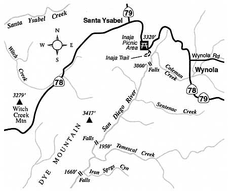
Waterfalls grace the upper reaches of the San Diego River, where only the most competent hikers tread.
A trip down the San Diego River canyon during the rainy season is a true adventure. (Mind you, we are not referring to the river at its lower Mission Valley segment, or even at Mission Gorge; rather, this section is way up in the mountains toward Julian.) Runoff from winter storms fills the rocky riverbed with a silvery band of water. Green grass, new leaves, and wildflowers (appearing by February or March) brighten the banks as well as the slopes. In several places along the way the stream cascades over rock precipices, including one with a drop of 100 hundred feet.
Bedrock morteros (grinding holes) along the river, especially near groves of oaks, attest to frequent use of the canyon by Native Americans for hundreds of years or more. Contemporary human usage pales by comparison; only an occasional hiker, backpacker, or hunter penetrates these canyon depths today.
Sturdy boots and a patient, cautious attitude are essential for exploring the canyon. This is a trek suitable only for those adept at moving through steep, rough terrain, and comfortable with occasional scrambling bordering on technical rock climbing. Get an early start if you are planning anything other than a brief, cursory look at the canyon. Keep in mind, too, that any substantially wet, winter-season storm could temporarily swell the usually indolent river flow to a dangerous level.
You may park at Inaja Picnic Area in the Cleveland National Forest, where you must post a National Forest Adventure Pass on your car for the privilege of parking. Start off by descending a precipitous slope south of the restrooms into the canyon's oak-shaded floor, a short distance below. Turn down-canyon, and at 0.5 mile arrive at the first falls, a set of two, each about 50 feet high. To get by, you'll probably need to traverse through brush and over tilted rock slabs on the right (west) side. If you don't like this dicey maneuver, go no further and turn back. You will encounter nothing but long stretches of boulder hopping, and occasional rock climbing ahead. The 2003 Cedar Fire incinerated the thick brush that was starting to make passages down the river canyon almost impossible. Now, however, that same vegetation is growing back.
After a total of 3.2 miles and perhaps 4 or more arduous hours, you'll come upon the lip of a 100-foot waterfall (elevation 1950 feet) -- the highest falls on the San Diego River. The water tumbles over a rock face and collects in a shallow pool perhaps 60 feet across. This destination is about as far as it is prudent to go in a full day. Remember that the hike back is all uphill and will almost certainly take a lot longer than did the hike down.
This article contains information about a publicly owned recreation or wilderness area. Trails and pathways are not necessarily marked. Conditions can change rapidly. Hikers should be properly equipped and have safety and navigational skills. The Reader and Jerry Schad assume no responsibility for any adverse experience.
Here's something you might be interested in.
Waterfalls grace the upper reaches of the San Diego River, where only the most competent hikers tread.
Waterfalls grace the upper reaches of the San Diego River, where only the most competent hikers tread.
A trip down the San Diego River canyon during the rainy season is a true adventure. (Mind you, we are not referring to the river at its lower Mission Valley segment, or even at Mission Gorge; rather, this section is way up in the mountains toward Julian.) Runoff from winter storms fills the rocky riverbed with a silvery band of water. Green grass, new leaves, and wildflowers (appearing by February or March) brighten the banks as well as the slopes. In several places along the way the stream cascades over rock precipices, including one with a drop of 100 hundred feet.
Bedrock morteros (grinding holes) along the river, especially near groves of oaks, attest to frequent use of the canyon by Native Americans for hundreds of years or more. Contemporary human usage pales by comparison; only an occasional hiker, backpacker, or hunter penetrates these canyon depths today.
Sturdy boots and a patient, cautious attitude are essential for exploring the canyon. This is a trek suitable only for those adept at moving through steep, rough terrain, and comfortable with occasional scrambling bordering on technical rock climbing. Get an early start if you are planning anything other than a brief, cursory look at the canyon. Keep in mind, too, that any substantially wet, winter-season storm could temporarily swell the usually indolent river flow to a dangerous level.
You may park at Inaja Picnic Area in the Cleveland National Forest, where you must post a National Forest Adventure Pass on your car for the privilege of parking. Start off by descending a precipitous slope south of the restrooms into the canyon's oak-shaded floor, a short distance below. Turn down-canyon, and at 0.5 mile arrive at the first falls, a set of two, each about 50 feet high. To get by, you'll probably need to traverse through brush and over tilted rock slabs on the right (west) side. If you don't like this dicey maneuver, go no further and turn back. You will encounter nothing but long stretches of boulder hopping, and occasional rock climbing ahead. The 2003 Cedar Fire incinerated the thick brush that was starting to make passages down the river canyon almost impossible. Now, however, that same vegetation is growing back.
After a total of 3.2 miles and perhaps 4 or more arduous hours, you'll come upon the lip of a 100-foot waterfall (elevation 1950 feet) -- the highest falls on the San Diego River. The water tumbles over a rock face and collects in a shallow pool perhaps 60 feet across. This destination is about as far as it is prudent to go in a full day. Remember that the hike back is all uphill and will almost certainly take a lot longer than did the hike down.
This article contains information about a publicly owned recreation or wilderness area. Trails and pathways are not necessarily marked. Conditions can change rapidly. Hikers should be properly equipped and have safety and navigational skills. The Reader and Jerry Schad assume no responsibility for any adverse experience.