Here's something you might be interested in.
Ask a Hipster — Advice you didn't know you needed
Big Screen — Movie commentary
Blurt — Music's inside track
Booze News — San Diego spirits
Classical Music — Immortal beauty
Classifieds — Free and easy
Close to Home — What it’s like on the street where you live
Cover Stories — Front-page features
Drinks All Around — Bartenders' drink recipes
Excerpts — Literary and spiritual excerpts
Feast! — Food & drink reviews
Feature Stories — Local news & stories
Fishing Report — What’s getting hooked from ship and shore
From the Archives — Spotlight on the past
Golden Dreams — Talk of the town
The Gonzo Report — Making the musical scene, or at least reporting from it
Letters — Our inbox
Movies@Home — Local movie buffs share favorites
Movie Reviews — Our critics' picks and pans
Musician Interviews — Up close with local artists
Neighborhood News from Stringers — Hyperlocal news
News Ticker — News & politics
Obermeyer — San Diego politics illustrated
Outdoors — Weekly changes in flora and fauna
Overheard in San Diego — Eavesdropping illustrated
Poetry — The old and the new
Reader Travel — Travel section built by travelers
Reading — The hunt for intellectuals
Roam-O-Rama — SoCal's best hiking/biking trails
San Diego Beer — Inside San Diego suds
SD on the QT — Almost factual news
Sheep and Goats — Places of worship
Special Issues — The best of
Street Style — San Diego streets have style
Surf Diego — Real stories from those braving the waves
Theater — On stage in San Diego this week
Tin Fork — Silver spoon alternative
Under the Radar — Matt Potter's undercover work
Unforgettable — Long-ago San Diego
Unreal Estate — San Diego's priciest pads
Your Week — Daily event picks
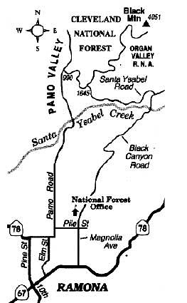
"Big" Black Mountain outside Ramona offers a unique perspective of central San Diego County's geography.
San Diego County's "big" Black Mountain (not the smaller one looming above Rancho Peñasquitos) rises gently to an elevation of 4051 feet outside Ramona. A fire-lookout tower once stood on Black Mountain's summit, taking full advantage of a panoramic -- and certainly unique -- vista furnished by the mountain's strategic central location within the county.
Hikers, bikers, runners, equestrians, and four-wheel drivers have public access to Black Mountain's summit via a winding fire road up the southwest flank -- though motorized vehicles will get no closer than one mile (or more distance if the road is impacted by weather) from the top. Unquestionably, the late-winter period is perfect for an exercise-oriented trek up this road. The air's clear and cool through March, and the dominant chaparral vegetation hereabouts is dressed up in its best spring-green foliage.
To reach the base of Black Mountain, first head for Pamo Road, using either Haverford Road off Highway 78 north of Ramona or Seventh Street (becomes Elm Street) north from "downtown" Ramona. As you drive north on Pamo Road, your car pitches deeply downhill into the sublime and isolated Pamo Valley. Continue north in the valley to where the pavement ends and further 1.3 miles to a dirt-road intersection on the right, Forest Road 12S07. You may park near this intersection, or else (using a high-clearance vehicle only) drive 1.5 rutty miles uphill to a wide intersection where Black Mountain fire road forks left. Parking at this upper starting point (elevation 1645 feet) requires that a National Forest Adventure Pass be displayed on your car.
From the upper starting point, 5.6 miles of moderate and almost unrelenting ascent lie ahead. As you climb toward the mountain's broad summit, scrubby chamise chaparral gradually yields to sparse Engelmann oak woodland, and finally to planted groves of coniferous trees (mostly Coulter pines). The Organ Valley Research Natural Area, a square mile of oak-dotted ravines and slopes in Cleveland National Forest designated for special protection, lies east of the road. You may notice a hiker's entryway into this natural area 3.3 miles up the road. At 3.8 miles you'll pass a perennial spring and fire-fighting reservoir, where horses and dogs can fill their bellies with cool, slightly murky water.
The road ends 5.4 miles up, and a final rough 0.2 mile on bulldozed former roadway lets hikers reach the fire-tower site. Concrete steps, footings, and a cistern remain amid a surviving ground-covering carpet of vinca, or periwinkle. Using fingers and toes you can launch yourself atop the cistern. There you can spin your head around for a 360-degree panorama not available elsewhere: rolling pasturelands in Mesa Grande a mile or two north and east, and range after range of mountains in every direction except west, where the cobalt-blue or sparkling silver ocean reveals itself on the clearest days.
Here's something you might be interested in.
"Big" Black Mountain outside Ramona offers a unique perspective of central San Diego County's geography.
"Big" Black Mountain outside Ramona offers a unique perspective of central San Diego County's geography.
San Diego County's "big" Black Mountain (not the smaller one looming above Rancho Peñasquitos) rises gently to an elevation of 4051 feet outside Ramona. A fire-lookout tower once stood on Black Mountain's summit, taking full advantage of a panoramic -- and certainly unique -- vista furnished by the mountain's strategic central location within the county.
Hikers, bikers, runners, equestrians, and four-wheel drivers have public access to Black Mountain's summit via a winding fire road up the southwest flank -- though motorized vehicles will get no closer than one mile (or more distance if the road is impacted by weather) from the top. Unquestionably, the late-winter period is perfect for an exercise-oriented trek up this road. The air's clear and cool through March, and the dominant chaparral vegetation hereabouts is dressed up in its best spring-green foliage.
To reach the base of Black Mountain, first head for Pamo Road, using either Haverford Road off Highway 78 north of Ramona or Seventh Street (becomes Elm Street) north from "downtown" Ramona. As you drive north on Pamo Road, your car pitches deeply downhill into the sublime and isolated Pamo Valley. Continue north in the valley to where the pavement ends and further 1.3 miles to a dirt-road intersection on the right, Forest Road 12S07. You may park near this intersection, or else (using a high-clearance vehicle only) drive 1.5 rutty miles uphill to a wide intersection where Black Mountain fire road forks left. Parking at this upper starting point (elevation 1645 feet) requires that a National Forest Adventure Pass be displayed on your car.
From the upper starting point, 5.6 miles of moderate and almost unrelenting ascent lie ahead. As you climb toward the mountain's broad summit, scrubby chamise chaparral gradually yields to sparse Engelmann oak woodland, and finally to planted groves of coniferous trees (mostly Coulter pines). The Organ Valley Research Natural Area, a square mile of oak-dotted ravines and slopes in Cleveland National Forest designated for special protection, lies east of the road. You may notice a hiker's entryway into this natural area 3.3 miles up the road. At 3.8 miles you'll pass a perennial spring and fire-fighting reservoir, where horses and dogs can fill their bellies with cool, slightly murky water.
The road ends 5.4 miles up, and a final rough 0.2 mile on bulldozed former roadway lets hikers reach the fire-tower site. Concrete steps, footings, and a cistern remain amid a surviving ground-covering carpet of vinca, or periwinkle. Using fingers and toes you can launch yourself atop the cistern. There you can spin your head around for a 360-degree panorama not available elsewhere: rolling pasturelands in Mesa Grande a mile or two north and east, and range after range of mountains in every direction except west, where the cobalt-blue or sparkling silver ocean reveals itself on the clearest days.